
Where Flight Simulation Enthusiasts Gather from Around the World!
AVSIM Library - Search Results

| Category: Flight Simulator X - Scenery | |
| Barbados island photo scenery |

|
File Description:
Barbados is my home island so I've decided to make a photo scenery for it. please understand that am not a professional at scenery but if anyone is willing to help me improve it, am open for it.
Barbados is a sovereign island country in the Lesser Antilles, in the Americas. It is 34 kilometres (21 miles) in length and up to 23 km (14 mi) in width,
covering an area of 432 km2 (167 sq mi). It is situated in the western area of the North Atlantic and 100 km (62 mi) east of the Windward Islands and the Caribbean Sea;[6] therein,
it is about 168 km (104 mi) east of the islands of Saint Vincent and the Grenadines and 400 km (250 mi) north-east of Trinidad and Tobago. Barbados is outside of the principal Atlantic hurricane belt.
Its capital is Bridgetown. Barbados is 1,600 mi (2,600 km) Southeast of Miami.
| Filename: | Barbados_island_photo_scenery.zip |
| License: | Freeware |
| Added: | 5th October 2016, 22:31:01 |
| Downloads: | 630 |
| Author: | Shakur Jones |
| Size: | 55.73 MB |
| Category: Flight Simulator X - Scenery | |
| Barbados Island Scenery V2 |
|
File Description:
UPDATED 01/05/2017
Photoscenery for Barbados island for FSX/P3D
Thank you for downloading my first scenery.
I've decided to make my first scenery of my home island Barbados, am very proud of my work and I hope you enjoy it.
UPDATE:
Fixed the Blendmask
Fixed the watermask
added rivers, port and more to the watermask
Barbados is a sovereign island country in the Lesser Antilles, in the Americas. It is 34 kilometres (21 miles) in length and up to 23 km (14 mi) in width,
covering an area of 432 km2 (167 sq mi). It is situated in the western area of the North Atlantic and 100 km (62 mi) east of the Windward Islands and the Caribbean Sea;[6] therein,
it is about 168 km (104 mi) east of the islands of Saint Vincent and the Grenadines and 400 km (250 mi) north-east of Trinidad and Tobago. Barbados is outside of the principal Atlantic hurricane belt.
Its capital is Bridgetown. Barbados is 1,600 mi (2,600 km) Southeast of Miami.
| Filename: | Barbados_Island_Scenery_V2.zip |
| License: | Freeware |
| Added: | 6th January 2017, 08:36:45 |
| Downloads: | 1,788 |
| Author: | Shakur Jones |
| Size: | 80.48 MB |
| Category: Flight Simulator X - Scenery | |
| Saratoga County Airport Fix |
|
Images related to this file:
File Description:
Saratoga County Airport (5B2) v2.0 ADE fix. Reworked ADE file to fix bad parking spot links. AI traffic navigate to and from parking spots correctly with this release. Requires 5B2_X_v2.zip
| Filename: | Saratoga_County_Airport_Fix.zip |
| License: | Freeware, limited distribution |
| Added: | 8th May 2012, 02:44:34 |
| Downloads: | 795 |
| Author: | EdGeneer Cox |
| Size: | 6.11 KB |
| Category: Flight Simulator X - Scenery | |
| Bloemfontein Airport, South Africa (FABL) |
|
Images related to this file:
File Description:
This is Bloemfontein Airport in South Africa.It is freeware and made with custom designed buildings,AFCAD,photoreal that change seasons to be used with Bloemfontein VFR V2.0.get it here at avsim.com
| Filename: | Bloemfontein_Airport_South_Africa_FABL.zip |
| License: | Freeware |
| Added: | 27th May 2012, 04:52:32 |
| Downloads: | 3,023 |
| Author: | Frits Beyer |
| Size: | 59.49 MB |
| Category: Flight Simulator X - Scenery | |
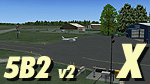
| Saratoga County Airport v2.0 - 5B2 |
|
Images related to this file:
File Description:

5B2 - Saratoga County Airport v2.0 for FSX Acceleration. Located in the foothills of the Adirondack Mountains in upstate NY, USA. This facility is owned by Saratoga County, formerly housed Rich Air and currently houses North American Aviation. 5B2 is a non-controlled airfield catering to small engine a/c up to a few private jet daily traffic serving 'The Northcountry' and Saratoga Springs, New York.
All Objects fully designed and completely redone in GMAX using high resolution photo-real textures. Optional seasonal files included. Also includes new ADEX file, more accurate airport grounds perimeter, satellite photo-real grounds, custom taxiways, taxi-signs and taxi lights. ADEX file also designed to support general aviation AI. All textures mipmapped for performance.
| Filename: | Saratoga_County_Airport_v20__5B2.zip |
| License: | Freeware, limited distribution |
| Added: | 2nd May 2012, 09:00:25 |
| Downloads: | 1,105 |
| Author: | Ed 'Geneer' Cox |
| Size: | 23.4 MB |
| Category: Flight Simulator X - Scenery | |
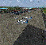
| TNCC - Hato International Airport - Curacao, Netherlands Antilles |
|
File Description:
Curacao International airport (TNCC).
Hato International Airport or Curacao International Airport (originally named Dr. Albert Plesman International Airport) is the airport of Willemstad, Curacao.
The terminal have been designed and are as realistic as possible.
| Filename: | TNCC___Hato_International_Airport__Curacao_Netherl.zip |
| License: | Freeware |
| Added: | 4th June 2016, 13:56:57 |
| Downloads: | 2,840 |
| Author: | Michel Boivin |
| Size: | 13.43 MB |
| Category: Flight Simulator X - Scenery | |
| WADD - Denpasar International Airport - Bali, Indonesia |
|
Images related to this file:
File Description:
Bali Ngurah Rai International Airport, also known as Denpasar International Airport, is located in southern Bali, 13 km south of Denpasar.
It is Indonesias third-busiest international airport.
| Filename: | WADD__Denpasar_International_Airport__Bali_Indones.zip |
| License: | Freeware |
| Added: | 31st May 2016, 16:17:59 |
| Downloads: | 12,749 |
| Author: | morten thomas van der linden |
| Size: | 60.67 MB |
| Category: Flight Simulator X - Scenery | |
| Pyongyang Sunan International Airport (ZKPY) v1.0 with Photoreal Scenery |
|
Images related to this file:
File Description:

Pyongyang Sunan International Airport (ZKPY)v1.0 with Photoreal Scenery for FSX
Pyongyang International Airport (IATA: FNJ, ICAO: ZKPY), also known as the Pyongyang Sunan International Airport, is the main airport serving Pyongyang, capital of North Korea. It is located in the city's Sunan District. As of August 2018, Air China and Air Koryo are servicing Pyongyang International Airport and the two destination countries from Pyongyang International Airport are China and Russia.
| Filename: | Pyongyang_Sunan_International_Airport_ZKPY_v10_with_Photoreal_Scenery.zip |
| License: | Freeware, limited distribution |
| Added: | 2nd February 2019, 17:17:33 |
| Downloads: | 3,213 |
| Author: | Aeron M. Tumanut |
| Size: | 9.47 MB |
| Category: Flight Simulator X - Scenery | |
| Caribbean South |
|
Images related to this file:
File Description:
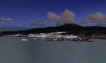
Scenery of the south caribban islands that includes Guadeloupe,Desirare,Les Saintes,marie galanta, Dominique,martinique, St Lucia,Barbados,St Vincent,Bequia,Mustique,Canouan,Union Island,Carriacou,Rondet,Grenade, Grenadines, Tobago and trinidad
| Filename: | Caribbean_South.zip |
| License: | Freeware |
| Added: | 7th September 2010, 20:02:40 |
| Downloads: | 2,975 |
| Author: | Toni Agramont |
| Size: | 18.86 MB |
| Category: Flight Simulator X - Scenery | |
| EDKE - Kamen-Heeren Airport - Germany V2.0 |
|
File Description:
Airport EDKE Kamen-Heeren for FSX SP2/Acceleration, Version 2.0
Version History:
1.0 First Version - ICAO EDKE
1.1 Correction ICAO EDGG
2.0 Realistic buildings, Back to ICAO EDKE (Remarks: Kamen-Heeren has no ICAO Code)
Kamen-Heeren (ICAO:EDKE) is a little german airport.
It is my first approach to build this airport.
For more pilot information, please visit the airport website:
http://www.lsf-kamen.de/index.php/flugplatz/infos-fuer-piloten
There you'll also find the needed maps.
| Filename: | EDKE__KamenHeeren_Airport___Germany_V20.zip |
| License: | Freeware |
| Added: | 17th September 2013, 04:43:24 |
| Downloads: | 781 |
| Author: | Juergen Depping |
| Size: | 4.18 MB |
© 2001-2026 AVSIM Online
All Rights Reserved
Privacy Policy |