
Where Flight Simulation Enthusiasts Gather from Around the World!
AVSIM Library - Search Results

| Category: Flight Simulator X - Gauges | |
| Airport Chart Gauge V2 |

|
File Description:
The first version was a disaster, due to a heavy error I made during packing the zip archive. This one will work.
The Airport Chart Gauge shows you the layout of an arbitrary airport, no matter, whether the airport is shipped with Flight Simulator or included in an Add-On. It doesn’t use any scanned charts, instead it takes its data directly from the Flight Simulator. The chart contains all taxiways, runways, heliports and parking places, including their identifiers, of course. With the Airport Chart Gauge you can easily find your way from your current parking place to the runway (or vice versa).
| Filename: | apchart.zip |
| License: | Freeware, limited distribution |
| Added: | 31st March 2008, 19:10:41 |
| Downloads: | 23,215 |
| Author: | Holger Maass |
| Size: | 5.59 MB |
| Category: Flight Simulator X - Gauges | |
| Bush Pilot Buddy 2.4 |
|
Images related to this file:
File Description:
GPS style airport info for nearby airfields. Displays airfield frequencies, ILS codes, NDB's, DME's etc
| Filename: | bpb24.zip |
| License: | Freeware |
| Added: | 23rd March 2024, 00:10:20 |
| Downloads: | 111 |
| Author: | palyarmerc |
| Size: | 25 KB |
| Category: Flight Simulator X - Gauges | |
| CB 5000 NAVRAD Navigational RADAR and Multi-Function Display ver 1.5 |
|
Images related to this file:
File Description:
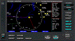
Some of the features included in this gauge are customizable Traffic RADAR, Map Panning, TAWS map, and Nearest Airport Search with a 375 nm range listing up to 500 airports. Instrumentation Manual Included. Come Check Us Out - www.coosbayhops.com
| Filename: | coos_bay_navrad_ver_1.5.zip |
| License: | Freeware, limited distribution |
| Added: | 20th March 2013, 08:19:09 |
| Downloads: | 2,395 |
| Author: | Greg Swift (CoosBay Hops) |
| Size: | 2.89 MB |
| Category: Flight Simulator X - Gauges | |
| FLTInfo V2 |
|
Images related to this file:
File Description:

This gauge has been developed for FSX Flight Simulator SP2 or SP1. It should also work with Acceleration, but this is not guaranteed by the author.
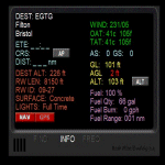
The gauge provides flight information for the pilot regarding the destination airport in terms of frequencies, runway conditions, altitude, bearing and distance, and basic information about the flight plan like current travelled miles and a estimated calculation about the Top Of Descent (TOD ) decision point.
This Version 2 includes 3 additional information pages for the runway layouts of the destination and the departure airport, and a page which provides graphical information about the terrain level relative to the aircraft on the selected flight plan.
For more information and installation instructions see the documentation inside the zip file.
| Filename: | fltinfo_v2.0.zip |
| License: | Freeware, limited distribution |
| Added: | 12th October 2012, 18:05:11 |
| Downloads: | 1,548 |
| Author: | Dietmar Loleit |
| Size: | 853 KB |
| Category: Flight Simulator X - Gauges | |
| Country Gauge |
|
Images related to this file:
File Description:
COUNTRY GAUGE
If you like to flight around the world, this little gauge will show you
the information of the nearest airport ( in around 1200 nm).
This information includes: true bearing, relative bearing, longest runway,
best approach, the city and the COUNTRY.
Don't get lost... know where you are. easy installation instructions.
COPYRIGHT
Created by: Ricardo Salas
| Filename: | country.zip |
| License: | Freeware |
| Added: | 30th July 2010, 00:24:39 |
| Downloads: | 1,370 |
| Author: | Ricardo Salas Aguirre |
| Size: | 66 KB |
| Category: Flight Simulator X - Gauges | |
| FLTInfo |
|
Images related to this file:
File Description:

This gauge has been developed for FSX Flight Simulator SP2 or SP1. It should also work with Acceleration, but this is not guaranteed by the author. The gauge provides flight information for the pilot regarding the destination airport in terms of frequencies, runway conditions, altitude, bearing and distance, and basic information about the flight plan like current traveled miles and a estimated calculation about the Top Of Descent (TOD ) decision point. For more information and installation instructions see the documentation inside the zip file.
| Filename: | fltinfo_v1.0.zip |
| License: | Freeware |
| Added: | 9th July 2012, 17:18:07 |
| Downloads: | 1,414 |
| Author: | Dietmar Loleit |
| Size: | 499 KB |
| Category: Flight Simulator X - Gauges | |
| Advanced Radar System 4 (ARS4) |
|
Images related to this file:
File Description:
This gauge has been developed for FSX Flight Simulator SP1 or SP2. It
has also been tested with Microsoft Acceleration also, but compatibility is not guaranteed by the author.
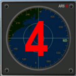
This new Advanced Radar System (ARS 4) includes significant new features,
functions and displays for FSX AI traffic. The new key features are:
1)AI traffic display for air targets and boat/ship targets.
2)Auto landing on carrier if the carrier is part of the scenery MECOPS.
3)Allows switching between air target display and boat target display.
4) Provides for air and boat display to optionally insert airport and/or basic terrain display on the screen.
5)Different screen presentations for air and boat targets.
6)Simplified installation procedure.
7)The A2A re-fuel function remains the same as in the ARS2 version.
8)The auto tracking function remains the same as well as in the ARS2 version.
All displays for air, or boat/ship traffic, can be selected in a range of 5, 10, 20, and 40 miles.
For installation and additional information look at the ARS4 documentation inside the zip file. For copyrights and credits please look at the documentation for this gauge.
| Filename: | ars4.zip |
| License: | Freeware |
| Added: | 5th March 2013, 15:53:52 |
| Downloads: | 3,777 |
| Author: | Dietmar Loleit |
| Size: | 1.18 MB |
© 2001-2025 AVSIM Online
All Rights Reserved