
Where Flight Simulation Enthusiasts Gather from Around the World!
AVSIM Library - Search Results

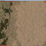
| Category: Flight Simulator X - Scenery | |
| Morocco VFR - Terrain Mesh SRTM 1 Arc/Sec version 3 - Volume 01 |

|
Images related to this file:
File Description:
Enhanced Terrain Mesh from data souce SRTM 1 Arc/Sec (30 meters) version 3 at LOD 11 (19mt meters/pixel). Coverage: Lat 31 to 37. Fully compatible also with P3D.
| Filename: | morocco_terrainmesh_srtm_1arcsec_part_02.zip |
| License: | Freeware |
| Added: | 22nd March 2015, 00:24:59 |
| Downloads: | 2,265 |
| Author: | Giovanni Miduri |
| Size: | 415.75 MB |
| Category: Flight Simulator X - Scenery | |
| Mesh South America / MeSA Galapagos |
|
File Description:
This terrain mesh file is a part of a whole project covering all the Continent of South America and some islands, divided in tiles identified in a map by its column (letters) and rows (numbers). Those files were multi-LOD compiled from 90m SRTM2 source data, reprocessed with 3DEM to remove voids and spikes, providing a 76.4m (LOD9) horizontal resolution topography intended for use only in FSX updated with SP1.
Although not well documented, to improve performance, the updated FSX loads DEM files in threads and only the closer terrain (about 5 NM from the point of view) is rendered in high detail, while at far distances FSX shows up its default low resolution mesh, when there is not a third part terrain mesh compiled in all others intermediate level of details (multi-LOD).
| Filename: | fsx_mesa_galapagos.zip |
| License: | Freeware |
| Added: | 10th June 2007, 21:03:25 |
| Downloads: | 1,345 |
| Author: | Hely Heck Jr. and José Lôbo |
| Size: | 1.81 MB |
| Category: Flight Simulator X - Scenery | |
| ITATIBA P1 - Photo Realistic Scenery |
|
File Description:
ITATIBA P1 - 1/2
This is the complement of Campinas to cover ITATIBA region. This scenery is composed by five parts. Folow instructions on Readme.txt and have a nice visual flight.
Is a good idea install the FSX Mesh South America parts F7 and F8 cordinates in the map to have the essential mesh terrain.
| Filename: | itatibap1_1.zip |
| License: | Freeware |
| Added: | 11th August 2008, 08:27:11 |
| Downloads: | 1,349 |
| Author: | Gilson A. Rocchetti |
| Size: | 47.69 MB |
| Category: Flight Simulator X - Scenery | |
| CYBA Banff V1.1 |
|
File Description:
CYBA Banff Airport Relocated to correct position and made runway to slope with terrain. Used default object libraries and Canada19 terrain mesh but this will work without it. Version 1.1 adds Banff townsite, removes trees from ends of runways, and fixes missing section of trans-canada highway. Screen shots have been removed to reduce download size
| Filename: | cyba_v1.1.zip |
| License: | Freeware |
| Added: | 21st June 2010, 10:56:52 |
| Downloads: | 1,476 |
| Author: | Rick Lackey |
| Size: | 4 KB |
| Category: Flight Simulator X - Scenery | |
| Mesh South America / MeSA E03 |
|
File Description:
FSX Mesh South America Project:
This terrain mesh file is a part of a whole project covering all the Continent
of South America and some islands, divided in tiles identified in a map by its
column (letters) and rows (numbers).
Those files were multi-LOD compiled from 90m SRTM2 source data, reprocessed
with 3DEM to remove voids and spikes, providing a 76.4m (LOD9) horizontal
resolution topography intended for use only in FSX updated with SP1.
Although not well documented, to improve performance, the updated FSX loads DEM
files in threads and only the closer terrain (about 5-10 NM from the point of view)
is rendered in high detail, while at far distances FSX shows up its default low
resolution mesh, when there is not a third part terrain mesh compiled in all
others intermediate level of details (multi-LOD).
THIS FILE:
FSX_MeSA_E03 (Column E x Row 03)
covers the area inside the boundaries:
N = 5º 37,5' N; S = 0º 0' S;
W = 60º 0' W; E = 52º 30' W;
| Filename: | fsx_mesa_e03.zip |
| License: | Freeware |
| Added: | 13th June 2007, 21:41:26 |
| Downloads: | 1,251 |
| Author: | Hely Heck Jr. and José Lôbo |
| Size: | 83.82 MB |
| Category: Flight Simulator X - Scenery | |
| FSX_MeSA_G08 |
|
File Description:
FSX Mesh South America Project:
This terrain mesh file is a part of a whole project covering all the Continent
of South America and some islands, divided in tiles identified in a map by its
column (letters) and rows (numbers).
Those files were multi-LOD compiled from 90m SRTM2 source data, reprocessed
with 3DEM to remove voids and spikes, providing a 76.4m (LOD9) horizontal
resolution topography intended for use only in FSX updated with SP1.
Although not well documented, to improve performance, the updated FSX loads DEM
files in threads and only the closer terrain (about 5-10 NM from the point of view)
is rendered in high detail, while at far distances FSX shows up its default low
resolution mesh, when there is not a third part terrain mesh compiled in all
others intermediate level of details (multi-LOD).
THIS FILE:
FSX_MeSA_G08 (Column G x Row 08)
covers the area inside the boundaries:
N = 22º 30' S; S = 28º 7.5' S;
W = 45º 0' W; E = 37º 30' W;
AUTHORS:
Hely Heck Junior - Magrao ( [email protected] )
and Jose Lobo ( [email protected] )
| Filename: | fsx_mesa_g08.zip |
| License: | Freeware |
| Added: | 15th June 2007, 15:04:47 |
| Downloads: | 1,132 |
| Author: | Hely Heck Jr. and José Lôbo |
| Size: | 12 MB |
| Category: Flight Simulator X - Scenery | |
| FSX_MeSA_H04 |
|
File Description:
FSX Mesh South America Project:
This terrain mesh file is a part of a whole project covering all the Continent
of South America and some islands, divided in tiles identified in a map by its
column (letters) and rows (numbers).
Those files were multi-LOD compiled from 90m SRTM2 source data, reprocessed
with 3DEM to remove voids and spikes, providing a 76.4m (LOD9) horizontal
resolution topography intended for use only in FSX updated with SP1.
Although not well documented, to improve performance, the updated FSX loads DEM
files in threads and only the closer terrain (about 5-10 NM from the point of view)
is rendered in high detail, while at far distances FSX shows up its default low
resolution mesh, when there is not a third part terrain mesh compiled in all
others intermediate level of details (multi-LOD).
THIS FILE:
FSX_MeSA_H04 (Column H x Row 04)
covers the area inside the boundaries:
N = 0º 0' S; S = 5º 37.5' S;
W = 37º 30' W; E = 30º 0' W;
AUTHORS:
Hely Heck Junior - Magrao ( [email protected] )
and Jose Lobo ( [email protected] )
| Filename: | fsx_mesa_h04.zip |
| License: | Freeware |
| Added: | 15th June 2007, 15:07:51 |
| Downloads: | 943 |
| Author: | Hely Heck Jr. and José Lôbo |
| Size: | 3.56 MB |
| Category: Flight Simulator X - Scenery | |
| FSX_MeSA_H05 |
|
File Description:
FSX Mesh South America Project:
This terrain mesh file is a part of a whole project covering all the Continent
of South America and some islands, divided in tiles identified in a map by its
column (letters) and rows (numbers).
Those files were multi-LOD compiled from 90m SRTM2 source data, reprocessed
with 3DEM to remove voids and spikes, providing a 76.4m (LOD9) horizontal
resolution topography intended for use only in FSX updated with SP1.
Although not well documented, to improve performance, the updated FSX loads DEM
files in threads and only the closer terrain (about 5-10 NM from the point of view)
is rendered in high detail, while at far distances FSX shows up its default low
resolution mesh, when there is not a third part terrain mesh compiled in all
others intermediate level of details (multi-LOD).
THIS FILE:
FSX_MeSA_H05 (Column H x Row 05)
covers the area inside the boundaries:
N = 5º 37.5' S; S = 11º 15' S;
W = 37º 30' W; E = 30º 0' W;
AUTHORS:
Hely Heck Junior - Magrao ( [email protected] )
and Jose Lobo ( [email protected] )
| Filename: | fsx_mesa_h05.zip |
| License: | Freeware |
| Added: | 15th June 2007, 15:08:10 |
| Downloads: | 943 |
| Author: | Hely Heck Jr. and José Lôbo |
| Size: | 22.93 MB |
| Category: Flight Simulator X - Scenery | |
| FSX_MeSA_H06 |
|
File Description:
FSX Mesh South America Project:
This terrain mesh file is a part of a whole project covering all the Continent
of South America and some islands, divided in tiles identified in a map by its
column (letters) and rows (numbers).
Those files were multi-LOD compiled from 90m SRTM2 source data, reprocessed
with 3DEM to remove voids and spikes, providing a 76.4m (LOD9) horizontal
resolution topography intended for use only in FSX updated with SP1.
Although not well documented, to improve performance, the updated FSX loads DEM
files in threads and only the closer terrain (about 5-10 NM from the point of view)
is rendered in high detail, while at far distances FSX shows up its default low
resolution mesh, when there is not a third part terrain mesh compiled in all
others intermediate level of details (multi-LOD).
THIS FILE:
FSX_MeSA_H06 (Column H x Row 06)
covers the area inside the boundaries:
N = 11º 15' S; S = 16º 52.5' S;
W = 37º 30' W; E = 30º 0' W;
AUTHORS:
Hely Heck Junior - Magrao ( [email protected] )
and Jose Lobo ( [email protected] )
| Filename: | fsx_mesa_h06.zip |
| License: | Freeware |
| Added: | 15th June 2007, 15:19:51 |
| Downloads: | 996 |
| Author: | Hely Heck Jr. and José Lôbo |
| Size: | 1.61 MB |
| Category: Flight Simulator X - Miscellaneous Files | |
| Morocco Vectors VFR |
|
Images related to this file:
File Description:
This project add and update vectors for Morocco and Western Sahara. Accurate coastline, lakes, roads, railways and river/streams. This vectors are optimized with Terrain Mesh SRTM 1 arc sec (LOD11). Scenery for FSX//P3Dv1/2/3/4.
| Filename: | moroccovectors_vfr.zip |
| License: | Freeware |
| Added: | 9th June 2017, 21:04:48 |
| Downloads: | 765 |
| Author: | Giovanni Miduri |
| Size: | 20.49 MB |
© 2001-2025 AVSIM Online
All Rights Reserved