
Where Flight Simulation Enthusiasts Gather from Around the World!
AVSIM Library - Search Results

| Category: Flight Simulator X - Missions | |
| HelicopterLighthouseMissionsVol91.zip |

|
File Description:
Six lighthouse tours: Faro Punta Carnero, Hog Island Shoal, Marais Harbour of Refuge, Neist Point, Sakonnet, and Sheringham Point.These missions were programmed in Windows 10 (64bit)for FSX Acceleration and will also work in FSX Steam, P3DV3,V4,V5,and V6. However, several of these tours have specific requirements of Orbx scenery which is detailed in the .txt instructions.Photos of all the lites are included in each mission set. Once again, be sure to read the instructions in the .txt files. These missions have been thoroughly tested and should work as described. Due to large topographic differences in P3DV5 and V6, there will be peculiarities, but the missions should still work.
| Filename: | HelicopterLighthouseMissionsVol91zip.zip |
| License: | Freeware |
| Added: | 1st May 2026, 20:54:09 |
| Downloads: | 8 |
| Author: | Helomissionman |
| Size: | 38.37 MB |
| Category: Flight Simulator X - Scenery | |
| Savannah, Georgia - USA |
|
Images related to this file:
File Description:
A large and detailed scenery of Savannah, Georgia. Includes downtown Savannah
and riverfront (with custom made buildings, hotels, convention center, gold domed
courthouse, and Talmadge Bridge), harbor with container terminal, AI ship traffic, and
a custom built streetcar to travel the downtown streets of Savannah.
KSAV Savannah/Hilton Head Intl Airport has a custom built terminal, Gulfstream factory, and Air National
Guard facility. KSVN Hunter AAF has a custom built US Coast Guard facility and AI helicopter
traffic. Coastal Tybee Island is represented with beachfront resorts and hotels, pier,
shopping district, and 2 functioning lighthouses. Great for the VFR flyer!
By Dan French.
| Filename: | Savannah_Georgia__USA.zip |
| License: | Freeware, limited distribution |
| Added: | 21st April 2014, 22:57:17 |
| Downloads: | 1,134 |
| Author: | Dan French |
| Size: | 11.51 MB |
| Category: Flight Simulator X - Scenery | |
| Crooked & Acklins Islands (MYCI-MYAP) - The Bahamas |
|
Images related to this file:
File Description:
These islands are sparsely populated, but FSX with UTX-TAC has Crooked Island containing cities with high-rise buildings instead of settlements. This has been adjusted somewhat in this scenery. Bahamasair has flights twice weekly to these islands with the landing at MYCI being one of the more challenging due to rising terrain at the east end of the short and narrow runway. Parking has been provided to accommodate those AI flights in this package. The scenery includes custom scenery objects, placement of library objects and landclass changes. Scenery is based on Google Earth, Bing Maps and photos taken locally, and it is optimized for use with UTX-TAC.
| Filename: | Crooked__Acklins_Islands_MYCIMYAP__The_Bahamas.zip |
| License: | Freeware |
| Added: | 27th September 2013, 20:39:10 |
| Downloads: | 1,157 |
| Author: | Art Poole |
| Size: | 4.4 MB |
| Category: Flight Simulator X - Missions | |
| HelicopterLighthouseMissionsVol94.zip |
|
File Description:
Six lighthouse tours:Cape Willoughby, Capo Suvero, Goose Rocks, Moose Peak, Petit Manan, and Ram Island Ledge.These missions were programmed in Windows 10 (64bit)for FSX Acceleration and will also work in FSX Steam, P3DV3,V4,V5,and V6. However, several of these tours have specific requirements of Orbx scenery which is detailed in the .txt instructions.Photos of all the lites are included in each mission set. Once again, be sure to read the instructions in the .txt files. These missions have been thoroughly tested and should work as described. Due to large topographic differences in P3DV5 and V6, there will be peculiarities, but the missions should still work.
| Filename: | HelicopterLighthouseMissionsVol94zip.zip |
| License: | Freeware |
| Added: | 23rd May 2026, 13:31:40 |
| Downloads: | 7 |
| Author: | Helomissionman |
| Size: | 33.99 MB |
| Category: Flight Simulator X - Scenery | |
| Palermo Punta Raisi LICJ 2011 |
|
Images related to this file:
File Description:

Palermo Falcone e Borsellino airport (also known as Punta Raisi) is an international airport serving the western part of Sicily Island. The airport itself is located 35 km west from Palermo. The airport (LICJ) ranks third by passenger number in southern Italy after Napoli and Catania. This scenery comes with custom terminals, tower, hangers, textures, night lighting, etc. It was designed to fit Mazzokan's Sicily photo scenery and Pietro Mauri's ItalyMesh2004. Both downloads are heavily encouraged. All details about these files are included in the LICJ 2011 User Manual. This scenery was created for FSX only. It has been tested with FSX sp2, but it should work fine with sp1.
| Filename: | Palermo_Punta_Raisi_LICJ_2011.zip |
| License: | Freeware, limited distribution |
| Added: | 30th March 2011, 00:47:52 |
| Downloads: | 6,185 |
| Author: | Thomas Lo Gerfo |
| Size: | 3.07 MB |
| Category: Flight Simulator X - Missions | |
| New! HelicopterLighthouseMissionsVol97.zip |
|
File Description:
Six lighthouse tours: Brijuni, Croatian 1, Croation 2, Mew Island, St.Elmo, and Vale Formoso.These missions were programmed in Windows 10 (64bit)for FSX Acceleration and will also work in FSX Steam, P3DV3,V4,V5,and V6. However, several of these tours have specific requirements of Orbx scenery which is detailed in the .txt instructions.Photos of all the lites are included in each mission set. Once again, be sure to read the instructions in the .txt files. These missions have been thoroughly tested and should work as described. Due to large topographic differences in P3DV5 and V6, there will be peculiarities, but the missions should still work.
| Filename: | HelicopterLighthouseMissionsVol97zip.zip |
| License: | Freeware |
| Added: | 12th June 2026, 18:38:26 |
| Downloads: | 7 |
| Author: | Helomissionman |
| Size: | 64.29 MB |
| Category: Flight Simulator X - Scenery | |
| The Dry Tortugas Photo Scenery |
|
Images related to this file:
File Description:
Where are the Dry Tortugas? Should you be wondering, at the western end of the Florida Keys. Located 68 miles west of Key West, they are accessible only by boat and of course via your favorite seaplane.
Source Data: National Agriculture Imagery Program (NAIP) Orthoimagery, 1 meter per pixel resolution. The scenery package also corrects the MS-FSX Island and Lighthouse position errors overlooked by UTX-USA and UTX-TAC.
For your finest virtual experience it is highly recommended you download, install and use with: South Florida and The Bahamas Water Class scenery. (S-FL_Bahamas_WC.zip)
Enjoy your flight and don't forget your Scuba Gear or the sunscreen! - Wally-Bob
| Filename: | The_Dry_Tortugas_Photo_Scenery.zip |
| License: | Freeware, limited distribution |
| Added: | 23rd August 2014, 11:08:17 |
| Downloads: | 918 |
| Author: | Walter Roberts |
| Size: | 50.9 MB |
| Category: Flight Simulator X - Scenery | |
| Virac Airport RPUV with Photoreal Scenery |
|
Images related to this file:
File Description:
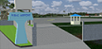
This is my reworked version of RPUV Airport. Now with Photorealistic Scenery, latest colors and updated terminal.
Virac Airport (IATA: VRC, ICAO: RPUV) is the only airport serving the island province of Catanduanes in the Philippines. It is located in the capital, Virac. The airport is classified as a Class 1 principal (major domestic) airport by the Civil Aviation Authority of the Philippines, a body of the Department of Transportation and Communications that is responsible for the operations of not only this airport but also of all other airports in the Philippines except the major international airports.
On October 27, 2013, Cebu Pacific launched the first ever Airbus flight in Virac.
| Filename: | Virac_Airport_RPUV_with_Photoreal_Scenery.zip |
| License: | Freeware |
| Added: | 26th November 2018, 16:20:24 |
| Downloads: | 829 |
| Author: | Aeron M. Tumanut |
| Size: | 35.35 MB |
| Category: Flight Simulator X - Scenery | |
| RAF High Ercall - Staffordshire, England |
|
File Description:
RAF High Ercall is a former Royal Air Force station situated near the village of High Ercall, seven miles north-east of Shrewsbury.
It was a post expansion station with work starting in 1938, however, personnel started arriving before it was fully finished in 1940. The unit had a variety of permanent buildings mainly located on the main unit site and the temporary accommodation and sick quarters were located on the south of the airfield.
The station closed for good in February 1962. Source: Wikipedia.
| Filename: | RAF_High_Ercall__Staffordshire_England.zip |
| License: | Freeware |
| Added: | 18th December 2015, 23:37:52 |
| Downloads: | 226 |
| Author: | Terry Boissel |
| Size: | 2.03 MB |
| Category: Flight Simulator X - Panels | |
| RAF Cammeringham |
|
File Description:
RAF Cammeringham (formerly RAF Ingham) was a Royal Air Force station used by RAF Bomber Command between 1940 and 1945 and the Polish Air Force until 1946. The airfield was located between the A15 (Ermine Street) and B1398 roads, 10.3 mi (16.6 km) north of the county town Lincoln, Lincolnshire, England and due east of the village of Ingham.
Mainly used as an overflow airfield for nearby RAF Hemswell and later as a training establishment, its continued use was limited by damage to its grassed runways. The airfield closed in early December 1946.
| Filename: | RAF_Cammeringham.zip |
| License: | Freeware |
| Added: | 19th October 2015, 11:01:21 |
| Downloads: | 202 |
| Author: | Terry Boissel |
| Size: | 13.17 KB |
© 2001-2026 AVSIM Online
All Rights Reserved
Privacy Policy |