
Where Flight Simulation Enthusiasts Gather from Around the World!
AVSIM Library - Search Results

| Category: Flight Simulator X - AFCAD Files | |
| BIKF - Keflavik - Keflavik, Iceland -V1.0 |

|
Images related to this file:
File Description:
BIKF - Keflavik - Keflavik, Iceland version 1.0 by Jason Boche
This is an update of the default FSX BIKF airport to simply remove the autogen trees growing in the middle of taxiway C-3.
All autogen trees within the rectangular block north of taxiway K-3, West of taxiway C-3, and East of taxiway K-4 have been removed.
Please provide any feedback and suggestions to me at the email address listed in the ReadMe.txt file. Thank You.
Jason Boche
| Filename: | BIKF__Keflavik__Keflavik_Iceland_V10.zip |
| License: | Freeware |
| Added: | 27th January 2014, 14:14:10 |
| Downloads: | 1,586 |
| Author: | Jason Boche |
| Size: | 153.47 KB |
| Category: Flight Simulator X - Scenery | |
| Buenos Aires 2008 - Argentina |
|
File Description:
This is the scenery of "Buenos Aires", República Argentina. This Scenery was conceived from a principle with the following two objectives: 1) To achieve the best performance; 2) A real appearance of the land. The area that cover this Scenery is the following one: End of the Delta of Paraná, Coastal area from Buenos Aires, From Escobar's North, Until the South of Quilmes, Capital Federal, Area West, The routes arrive until Campana and La Plata, and much more. By Pablo Contouris.
| Filename: | Buenos_Aires_2008__Argentina.zip |
| License: | Freeware, limited distribution |
| Added: | 7th July 2008, 02:59:26 |
| Downloads: | 2,001 |
| Author: | Pablo Contouris |
| Size: | 8.72 MB |
| Category: Flight Simulator X - Scenery | |
| Mesolonghi Airport - Rio-Antirio Bridge - Greece ** UPDATED VERSION ** |
|
Images related to this file:
File Description:
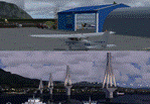
These are actually two sceneries offered in one pack. I started building the small airport of Mesolonghi in Western Greece. When nearing completion, I thought that FS was really missing the big suspension Bridge that connects mainland Greece with Peloponese that was finished in 2004, being the biggest in the world of the fully suspended type. The bridge project turned out bigger than the airport as I ended up doing the typical, Greek-style double ended ferries that served the straights for decades before the bridge and still offer a cheaper and, to some, more relaxing alternative.
Mesolonghi airport is situated 5 kilometers east of the historic city of Mesolonghi and is close to the technical school of fisheries. There is no ICAO code (ZZZZ) so I had to give it the fictional LGME in the sim. A purely day field, it houses the local Aeroclub and ultralight school. due to its small size and hospitable atmoshpere, it is a popular GA pilots destination, receiving also often international arrivals. The runway is asphalt and 800m (2635') in length. No PAPI or VASI are provided. There is no tower service and unicom frequency of 119.7MHz is used by the traffic. Closest controlled airport is Araxos (LGRX), a civil and military field, quite common in Greece, 12.5 nautical miles S-SE. The nearby city of Mesolonghi is famous for its heroic resistance and fall in 1826 during the Greek war of indepence. It is also famous for its fishery production, due to the natural lagoon, formed by the shallow waters.
Features of the Mesolonghi airport scenery include:
- Photoreal area with seasonal variations and watermask.
- Custom hangars and containerised buidings.
- AI default trike performing TnGs (in P3D it will work only if you copy over the FSX trike).
- The technical shool of fisheries on the north side.
- Customized shorelines, to fit with ORBX Global Vector.
- Optional shoreline fix for default scenery.
The Rio-Antirio bridge is located 14.5 nautical miles to the east of the airport. It connects the towns of Rio on the south side and Antirio on the north side. More data on the bridge can be found on Wikipedia.
Features of the Rio-Antirio bridge scenery include:
- Custom bridge model, bump mapped textures with hard platform surface and vehicle traffic.
- Night lighting textures and custom roadlights.
- Photoreal scenery for north and south shores, including hand placed autogen and night textures.
- Custom castle models on north and south sides, with bump mapped textures and night lighting.
- Custom model of the toll post on the north side.
- Custom AI ferry boats with constant shuttle service between Rio and Antirion piers.
- Customized shorelines, to fit with ORBX Global Vector.
- Optional shoreline fix for default scenery.
- Optional HDR optimized photoreal textures.
| Filename: | Mesolonghi_Airport__RioAntirio_Bridge__Greece___UP.zip |
| License: | Freeware |
| Added: | 16th March 2016, 09:15:21 |
| Downloads: | 2,626 |
| Author: | Vassilios Dimoulas |
| Size: | 300.05 MB |
| Category: Flight Simulator X - Scenery | |
| RAF Lichfield - Staffordshire, England |
|
File Description:
Royal Air Force Station Lichfield also known as Fradley Aerodrome, was an operational training station from 1940 until 1958. It was situated in Fradley, 2 miles north east of Lichfield, Staffordshire, England. The airfield was the busiest airfield in Staffordshire during World War II. The airfield supported its own units as well as providing safe haven for many more. It was a control point for all aviation traffic that passed through the Birmingham area during the war and saw more aircraft movements than any other Staffordshire airfield.
| Filename: | RAF_Lichfield__Staffordshire_England.zip |
| License: | Freeware |
| Added: | 15th December 2015, 21:59:09 |
| Downloads: | 184 |
| Author: | Terry Boissel |
| Size: | 1.29 MB |
| Category: Flight Simulator X - Scenery | |
| Boundary Bay Airport - CZBB |
|
File Description:
Located North and West of the community of Boundary Bay, so named because it is situated on the border between Canada and the United States. The airport is home to a large number of general aviation operations, as well as many flight training schools and flying clubs that provide aircraft rentals, safety seminars and social events. I have endeavored to represent the photos and satellite images through the use of FSX Deluxe library objects. VANCOUVER PLUS is required for this scenery to work correctly.
| Filename: | Boundary_Bay_Airport__CZBB.zip |
| License: | Freeware, limited distribution |
| Added: | 15th April 2009, 06:07:00 |
| Downloads: | 859 |
| Author: | Will Jones |
| Size: | 195.9 KB |
| Category: Flight Simulator X - Scenery | |
| Guildford Cathederal - England |
|
Images related to this file:
File Description:
This scenery adds the Guildford Cathedral to Orbx EU England Regional scenery package. Compatible with both FSX & P3D. Guildford Cathedral is the mother church of the Diocese of Guildford, covering 500 square miles of Surrey, north east Hampshire, the London Borough of Kingston and a part of West Sussex. With a seating capacity of 1000. Not tested with default FSX or any other setup. You must have Orbx EU England regional scenery to use the compiled scenery files as intended. By Bryan Wallis aka fltsimguy.
| Filename: | Guildford_Cathederal__England.zip |
| License: | Freeware, limited distribution |
| Added: | 26th January 2013, 03:54:32 |
| Downloads: | 848 |
| Author: | Bryan Wallis |
| Size: | 3.49 MB |
| Category: Flight Simulator X - Scenery | |
| ENHA - Hamar Lufthavn (Stafsberg) Update v 1.01 |
|
File Description:
The airport of Stafsberg located in Hamar, Norway (ENHA) Including all custom made ground, runway and 3D buildings. This VFR airport is located some 40 miles north of the capital Oslo, close to Lillehammer who hosted the 1994 Winter Olympics! Enjoy flying in one of the most beautifull countries in the world! Please read the included readme file for instructions on how to correctly install.
Update: Added New, like "The Real" one, NDB, removed default FSX NDB. Fixed some issues with effects file and some minor adjustments.
| Filename: | ENHA__Hamar_Lufthavn_Stafsberg__Update_v_101.zip |
| License: | Freeware, limited distribution |
| Added: | 5th September 2012, 00:30:44 |
| Downloads: | 2,118 |
| Author: | Thomas Lorentzen, Stein-Ove Rud |
| Size: | 1.11 MB |
| Category: Flight Simulator X - AFCAD Files | |
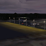
| UUOO - Voronezh Aiport. Russia |
|
File Description:
Voronezh Airport, Russia, serves 0.4 million passengers a year and is situated 11Km north of Voronezh.
I have changed the FSX stock airport to be in line with real aircraft parking, using ADEX. charts and Google Earth. I have also added several generic buildings to reflect the real airport.
You should download the brilliant car park package by Sidney Schwartz, modified my Martin Gossman at Owls Nest. Also the great lights package by Jim Dhaenens. Both can be found on AVSIM and other good flight sim libraries.
| Filename: | UUOO__Voronezh_Aiport_Russia.zip |
| License: | Freeware |
| Added: | 27th August 2016, 16:16:53 |
| Downloads: | 918 |
| Author: | Mike Major |
| Size: | 5.98 MB |
| Category: Flight Simulator X - Scenery | |
| Polokwane International Airport South Africa |
|
Images related to this file:
File Description:
Pietersburg International Airport or Polokwane International Airport (IATA: PTG, ICAO: FAPP)is an airport serving the city of Polokwane (known until 2005 as Pietersburg) in the South African province of Limpopo. Also known as Gateway Airport, it is located 5 km north of the city.The airport opened in 1996 on the site of a former Air Force Base.The airport has scheduled flights to Pietersburg.It handles approximately 5,000 aircraft and 38,000 passengers per year.Made from custom designed buildings and default FSX library objects.Works best with FSX acceleration.
| Filename: | Polokwane_International_Airport_South_Africa.zip |
| License: | Freeware |
| Added: | 28th January 2010, 20:32:40 |
| Downloads: | 1,516 |
| Author: | Jacques Botha |
| Size: | 1.18 MB |
| Category: Flight Simulator X - Scenery | |
| SBCC - The Cachimbo Air Base - Photoreal - Re-uploaded |
|
Images related to this file:
File Description:
The Cachimbo Air Base is a support base located in Serra do Cachimbo, south of Para State, in the Amazon Forest - Brazil. The unit was created with the main objective of serving as a base of support for aircrafts operations in the traffic link between the north and southeast of Brazil. Previously, the path could only be secure realized following the coast, a much longer way. Now you can fly this great scenery today and feel like how is operating in the middle of the Amazon Forest.
| Filename: | SBCC__The_Cachimbo_Air_Base__Photoreal__Reuploaded.zip |
| License: | Freeware, limited distribution |
| Added: | 27th December 2009, 09:02:24 |
| Downloads: | 2,946 |
| Author: | Jorge Amengol |
| Size: | 8.25 MB |
© 2001-2026 AVSIM Online
All Rights Reserved
Privacy Policy |