
Where Flight Simulation Enthusiasts Gather from Around the World!
AVSIM Library - Search Results

| Category: Flight Simulator X - Aircraft Repaints, Textures and Modifications | |
| Cyprus Turkish Airlines (KTHY) Airbus A32 (TC-KTC) |

|
Images related to this file:
File Description:
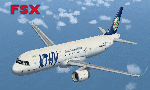
FSX default Airbus 321 repaint. Cyprus Turkish Airlines Airbus 321-211 KTHY(Kibris Turk Hava Yollari) registration TC-KTC (GIRNE). Cyprus Turkish Airlines currently adding new
Airbus 321's to its fleel for flights from North Cyprus Airports to
Europe and Turkey. Features full moving parts, night lighting and cockpit.
Original Aircraft by FSX Microsoft. Repaint By Serdar Nuzhet
| Filename: | Cyprus_Turkish_Airlines_KTHY__Airbus_A32_TCKTC.zip |
| License: | Freeware |
| Added: | 29th May 2010, 10:02:00 |
| Downloads: | 2,134 |
| Author: | Serdar Nuzhet |
| Size: | 3.84 MB |
| Category: Flight Simulator X - Aircraft Repaints, Textures and Modifications | |
| Skylease McDonnell-Douglas MD11F |
|
Images related to this file:
File Description:
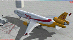
A repaint of the Payware PMDG MD 11F aircraft to represent N952AR, a cargo carrier for Skylease - a charter cargo company which started using the MD 11F in 2009.The company is affiliated to Centurion Cargo, and operates mainly in North and South America.
DDs textures with Alpha channels - photorealistic.
Tested in FSX; FS9 available on request.
| Filename: | Skylease_McDonnellDouglas_MD11F.zip |
| License: | Freeware |
| Added: | 16th March 2011, 23:54:08 |
| Downloads: | 255 |
| Author: | Bill Hardy |
| Size: | 873.53 KB |
| Category: Flight Simulator X - Scenery | |
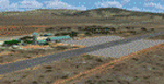
| CYPK - Pitt Meadows |
|
File Description:
Pitt Meadows Regional Airport is centrally located in the District of Pitt Meadows, north of the Fraser River, serving the Lower Mainland and Fraser Valley regions. It is 2.5 km east of the junction of the Pitt and Fraser Rivers, and only a 45-minute drive to downtown Vancouver, and 40 minutes to Abbotsford and the Fraser Valley.
| Filename: | CYPK__Pitt_Meadows.zip |
| License: | Freeware |
| Added: | 29th March 2009, 02:46:43 |
| Downloads: | 968 |
| Author: | Daniel Louvet |
| Size: | 937.97 KB |
| Category: Flight Simulator X - Scenery | |
| Radissonie Project |
|
Images related to this file:
File Description:
This set of files is intended to enhance the Radissonie area located on the center North part of Quebec, where dams have been erected on the La Grande river and surroundings. You must have installed Ultimate Terrain X Canada in order to have a fairly good mapping of the area. French and English instructions in the readme files.
| Filename: | Radissonie_Project.zip |
| License: | Freeware |
| Added: | 26th November 2009, 16:28:42 |
| Downloads: | 597 |
| Author: | Pierre Fauteux |
| Size: | 49.89 KB |
| Category: Flight Simulator X - AFCAD Files | |
| OAIX - Bagram Airfield - Bagram, Afghanistan |
|
File Description:
Bagram - OAIX/OAI is the largest U.S. military base in Afghanistan. It is located approximately 25 miles North of Kabul International Airport.
This airport was designed using the latest freeware version of Airport Design Editor from ScruffyDuck Software. Only stock library objects were used. Digital-Terminal Procedures and Google Earth were used as reference material.
| Filename: | OAIX__Bagram_Airfield__Bagram_Afghanistan.zip |
| License: | Freeware |
| Added: | 21st July 2014, 06:55:06 |
| Downloads: | 614 |
| Author: | Bill Bridges |
| Size: | 11.18 KB |
| Category: Flight Simulator X - Scenery | |
| Faroe Islands mesh and scenery |
|
File Description:
Welcome to the Faroe Islands. Our complete mesh and scenery will let you enjoy these beautiful North Atlantic islands. The only airport of the islands is modelled together with all helipads, towns, ports, road traffic and much more. A FSX-style flight plan for Atlantic Airways (2007, week 36) is included.
Please read the manual for further information.
| Filename: | Faroe_Islands_mesh_and_scenery.zip |
| License: | Freeware, limited distribution |
| Added: | 28th August 2007, 15:48:07 |
| Downloads: | 7,268 |
| Author: | Ryan Andersen and Peter H. Poulsen |
| Size: | 18.18 MB |
| Category: Flight Simulator X - Scenery | |
| California Central Coast Scenery Complete |
|
File Description:
This is a compilation of CCCFSX.ZIP released on 4/25/08 plus all the subsequent revisions (1 through 4). If you've already installed CCCFSX.ZIP and it's 4 revisions, you don't need this file. This scenery covers the California Central Coast from Paso Robles in the North to Santa Barbara in the South with about 22 points of interest.
| Filename: | California_Central_Coast_Scenery_Complete.zip |
| License: | Freeware |
| Added: | 20th December 2008, 17:46:21 |
| Downloads: | 2,367 |
| Author: | Al Wheeler |
| Size: | 6.06 MB |
| Category: Flight Simulator X - Scenery | |
| Roodewal Weapons Test Range-FARW |
|
Images related to this file:
File Description:
FSX/P3Dv3 Photo real scenery of the shooting area: Roodewal weapons test range in the north east of South Africa, it content of an airfield FARW with a 38x2390 runway, and some homemade buildings, shooting target, some animated tanks and missile launchers. I have made the scenery after a request from Willie a South African flight-simmer.
Otto Knudsen
| Filename: | Roodewal_Weapons_Test_RangeFARW.zip |
| License: | Freeware |
| Added: | 30th April 2018, 17:30:58 |
| Downloads: | 363 |
| Author: | Otto Knudsen |
| Size: | 51.98 MB |
| Category: Flight Simulator X - Scenery | |
| GCFV, GCLA , GCLP, GCRR, GCTS, GCXO - Canary Islands, Spain |
|
File Description:
This is a puristic, frame rate friendly scenery.
GCFV Fuerteventura, GCLA La Palma, GCLP Gran Canaria, GCRR Lanzarote, GCTS Tenerife South and GCXO Tenerife North are included.
Terminals have gate signs to show the number of the gate and ground painted taxiway signs for better orientation. Tested with FSX and P3D V2.5. Taxiways as per January 2015.
| Filename: | GCFV_GCLA__GCLP_GCRR_GCTS_GCXO__Canary_Islands_Spa.zip |
| License: | Freeware, limited distribution |
| Added: | 17th May 2015, 11:16:32 |
| Downloads: | 12,554 |
| Author: | Stefan Liebe |
| Size: | 1.6 MB |
| Category: Flight Simulator X - AFCAD Files | |
| Buck's Airport (00N), NJ |
|
File Description:
Located 03 miles NE of Bridgeton, New Jersey on 63 acres of land, Buck's Airport is a small turf field privately owned by J. Di Orio and open to the public. The field in FSX has room for 8 small GA aircraft to park on the square of grass north of the greenhouses. Be careful of the trees to the north and south of the runway.
Scenery constructed with use of Google Maps images, the author has not been there in person.
This scenery is meant to be used in conjunction with MegaScenery Earth New Jersey/Delaware 004. It is not required, but apron use is minimized to allow satellite scenery to show through as much as possible - lack of it may make scenery look out of place.
| Filename: | Bucks_Airport_00N_NJ.zip |
| License: | Freeware |
| Added: | 3rd October 2010, 23:47:29 |
| Downloads: | 233 |
| Author: | Drew Sikora |
| Size: | 566.5 KB |
© 2001-2026 AVSIM Online
All Rights Reserved
Privacy Policy |