
Where Flight Simulation Enthusiasts Gather from Around the World!
AVSIM Library - Search Results

| Category: Flight Simulator X - Utilities | |
| NumberPad Control for FSX and P3D |

|
Images related to this file:
File Description:
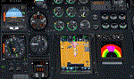
NpC4FSX&P3D (NumberPadControl for FSX and P3D) is a more efficient (and more convenient to set up)
version of a similar NpC program that I wrote a few years ago and which to
my surprise PC Pilot magazine included on their 100th Anniversary edition Freeware CD. With
NpC4FSX&P3D you assign keys to functions like Com, Nav, Heading, Course, Altitude, VS,
Autopilot functions, etc., and then can enter the associated values (like frequencies or headings) just by typing on the
keyboard’s numberpad instead of fiddling with elusive mouse click spots. NpC4FSX&P3D is
programmed primarily for aircraft with avionics that were developed within standard FSX
programming guidelines but also supports third party add-
on aircraft such as the Flysimware L35A and MU2, PMDG 737NGX / B777, Flight1 King Air
B200, A2A Cherokee 180, and also works with GPS units like the GTN750. Setup manual included.
A registered (payware) copy of FSUIPC is required.
| Filename: | NumberPad_Control_for_FSX_and_P3D.zip |
| License: | Freeware |
| Added: | 19th February 2018, 21:21:16 |
| Downloads: | 481 |
| Author: | Al Klayton |
| Size: | 683.59 KB |
| Category: Flight Simulator X - Scenery | |
| Whale Island Scenery: "Islands of the Bay of Plenty" |
|
File Description:
This scenery was created from a digital Orthorectified aerial mosaic owned by Environment Bay of Plenty (The Bay of Plenty Regional Council). The imagery has been de-sampled for use in Flight Simulator X and utilizes the default terrain mesh. The textures are intended for summer daylight flying only, although due to the sparse nature of White Islands' Evegetation, the Islands appearance remains relatively consistent throughout the year.
It includes autogen trees, a landable helicopter pad on the top of the Island, Radio masts, and the Department of Conservation (DOC) hut in the south western bay of the island.
| Filename: | Whale_Island_Scenery__Islands_of_the_Bay_of_Plenty.zip |
| License: | Freeware, limited distribution |
| Added: | 9th May 2007, 08:42:59 |
| Downloads: | 1,496 |
| Author: | Tim Barnes |
| Size: | 7.05 MB |
| Category: Flight Simulator X - Scenery | |
| Thraki |
|
Images related to this file:
File Description:
AS REAL AS IT GETS.
This is a detailed photorealistic scenery of southern Thraki.
Default FSX airports of Alexandroupoli (LGAL) and Komotini (Z11W) were completely redone, positioned to their exact location, and many buildings and objects were added in the airport compounds.
New aprons, taxi signs and plenty of aircraft parking.
New models for Komotini airport terminal building (not original), building signs, barracks and military vehicles all with night textures.
The scenery contains plenty of autogen objects, buildings, vegetation and road traffic near the airports.
I have also included 2 aircraft traffic files and 1 helicopter traffic file.
| Filename: | Thraki.zip |
| License: | Freeware |
| Added: | 26th September 2011, 14:41:10 |
| Downloads: | 1,920 |
| Author: | Angelo Tassoglou |
| Size: | 231.55 MB |
| Category: Flight Simulator X - Missions | |
| Emergency Services Mission 001 |
|
Images related to this file:
File Description:
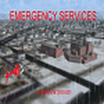
This is a series of missions called Emergency Services. All mission are flown using the Bell 206B JetRanger Helicopter. You may be flying for Fire Rescue, Medical Rescue or for the Police. Each mission is given an incident number. You will be required to navigate to these incident using the navigation charts or street maps. NO POINTERS are in any of these mission. Print the maps prior to your flight. You will be given the coodinates during your briefing. You will need to plot your own course to each destination.
In this mission you will be flying for Fire Rescue.
| Filename: | Emergency_Services_Mission_001.zip |
| License: | Freeware |
| Added: | 12th January 2010, 23:54:36 |
| Downloads: | 1,557 |
| Author: | David J Crandall |
| Size: | 15.47 MB |
| Category: Flight Simulator X - Scenery | |
| Kavala |
|
Images related to this file:
File Description:

AS REAL AS IT GETS.
This is a highly detailed photorealistic scenery of beautiful Kavala and the Island of Thasos.
The scenery contains many objects like cars, boats and buldings in many cities like Kavala, Keramoti, Thasos and around the airport.
Default FSX airport Megas Alexandros (LGKV) was corrected and repositioned to the exact location, runway 05L was added, many buildings and trees, aircraft hangers, airforce static aircraft and army vehicles.
Also I have added a small aircraft traffic file including a small file for helicopter traffic.
Check the Oil Rig in Kavala Bay and try to land on the helipad.
| Filename: | Kavala.zip |
| License: | Freeware |
| Added: | 14th July 2011, 04:57:38 |
| Downloads: | 3,004 |
| Author: | Angelo Tassoglou |
| Size: | 246.42 MB |
| Category: Flight Simulator X - AFCAD Files | |
| EGAA - Belfast Intl. - Belfast, Northern Ireland |
|
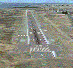
Images related to this file:
File Description:
Belfast International Airport is a major airport located 21 km northwest of Belfast in Northern Ireland. It was formerly known and is still referred to as Aldergrove Airport, after the nearby village of Aldergrove, which lies immediately to the west of the airport. The airfield was previously shared with the Royal Air Force base RAF Aldergrove, which closed in 2008; the base is now known as Joint Helicopter Command Flying Station, Aldergrove, and both runways are now owned by the airport.
Using ADEx 1.55, aeronautical maps and Google Earth the default AFCAD has been completely reworked to reflect today´s situation.
| Filename: | EGAA__Belfast_Intl__Belfast_Northern_Ireland.zip |
| License: | Freeware |
| Added: | 19th March 2013, 11:05:23 |
| Downloads: | 899 |
| Author: | Menno C. Robert |
| Size: | 696.24 KB |
| Category: Flight Simulator X - Missions | |
| SAR...Bimbo, Zula, Dobo |
|
File Description:
Russian Circus " Flying Sagitarius" (ïîëåò Sagitarious ) is visiting
Georgia and its mountain communities. Due to the cold weather, not expected by Yokoliv Burulov,
owner and trapeze swinger of the circus, three of his "stars" had to be taken by truck to a hospital since
their bowels have suffered " Dirruscus-Megra" a common cold water desease in the mountains. The three
ill "stars" are the Elephant "Bimbo"--"Zula" the laughfing Zebra and "Dobo" the great Dansing Russian Brown Bear...
Together these animals are worth around 75,000 Rubles in the Circus Markets.----Now Yokoliv has received
a call that the truck had an accident on the road and the three characters have run into the mountains. Not
wasting time he has asked the nearby Air Force Base for help. General Gustrgy Bonklovsky commander of the base and circus lover, has agreed to provide him with a SAR helicopter that will search the area and find at all cost the Animals....You are called to be the pilot for the mission at hand. Its cold, muggy and for the last three days fog has been lingering all over the mountains.---"this is the life pilot" says General Bonklovsky , as he hands you the search area map with a sardonic smile. You smell the presence of resently drunk Vodka and leave the hut toward the spinning Chopper.---Download MI-8 Helicopter for Mission
| Filename: | SARBimbo_Zula_Dobo.zip |
| License: | Freeware, limited distribution |
| Added: | 28th April 2008, 04:29:52 |
| Downloads: | 1,166 |
| Author: | Gera Godoy Canova |
| Size: | 5.96 MB |
| Category: Flight Simulator X - Scenery | |
| EDTQ Pattonville |
|
Images related to this file:
File Description:
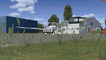
Airfield Pattonville (ICAO-Code: EDTQ)
See http://pattonville.pa.funpic.de/ for more information.
The Airfield Pattonville is a small airfield north of Stuttgart in southern germany. It is used by several aviator-clubs and hosts the base for a rescue helicopter. The runway suits for planes up till 3.5 tons.
This airfield was built bevor 2nd world war between Kornwestheim and Remseck-Aldingen. After WW2 it was used by the US-army and named "Ludwigsburg Army Airfield" and hosted missile-Launchpads during the Korea-war.
Since 16th of Juli 2003 The Airfield Pattonville is name as �������¢����������������Sonderlandeplatz Pattonville�������¢���������������� and has ICAO-Code EDTQ.
Due to the rising amount of airtraffic at Airport EDDS Stuttgart, the rescue-helicopter 'Christoph 51' moved to Pattonville at 1st of October 2009.
| Filename: | EDTQ_Pattonville.zip |
| License: | Freeware |
| Added: | 18th May 2012, 23:00:49 |
| Downloads: | 2,338 |
| Author: | Joe Herwig |
| Size: | 12.96 MB |
| Category: Flight Simulator X - Aircraft Repaints, Textures and Modifications | |
| Canadian Forces S.A.R. Bell Boeing V-22 Osprey |
|
File Description:
FSX Canadian Forces SAR Osprey. Textures only for the Virtavia Bell Boeing V-22 Osprey. The Bell Boeing V22 Osprey is an American multi-mission, military, tiltrotor aircraft with both a vertical takeoff and landing (VTOL), and short takeoff and landing (STOL) capability. It is designed to combine the functionality of a conventional helicopter with the long-range, high-speed cruise performance of a turboprop aircraft. Although a fictional Canadian Forces Search and Rescue paint scheme, Bell/Boeing has submitted a bid to replace Canada's SAR aircraft. If these "textures" are flown for "testing and evaluation purposes" it can be deemed "As real as it gets". Textures by Gary Moore.
| Filename: | Canadian_Forces_SAR_Bell_Boeing_V22_Osprey.zip |
| License: | Freeware, limited distribution |
| Added: | 16th June 2014, 07:32:55 |
| Downloads: | 446 |
| Author: | Gary Moore |
| Size: | 2.7 MB |
| Category: Flight Simulator X - Aircraft Repaints, Textures and Modifications | |
| Army Air Corps Islander BN-2 |
|
Images related to this file:
File Description:
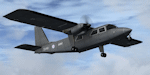
Repaint for the payware FSX Britten-Norman BN2 from Flight1 in the colors of Britain's Army Air Corps (AAC). This repaint represents an Islander AL1 based at Joint Helicopter Command (JHC) Flying Station Aldergrove (Northern Ireland) with 651 Squadron AAC. Islander gray instrument panel by Frank Safranek (BN-2_GRAY_PNL.ZIP) is recommended. Please note the AL1 is a version of the three-bladed, turbine-engined BN-2T. However the Flight1 models are BN-2A and BN-2B two-bladed, piston-engined variants. The AL1 is also fitted with a radar altimeter, infra-red line scanner (IRLS) and vertical cameras, none of which are modelled in the Flight1 variants.
| Filename: | Army_Air_Corps_Islander_BN2.zip |
| License: | Freeware, limited distribution |
| Added: | 26th May 2010, 03:23:06 |
| Downloads: | 529 |
| Author: | Andy Ford |
| Size: | 4.95 MB |
© 2001-2026 AVSIM Online
All Rights Reserved
Privacy Policy |