
Where Flight Simulation Enthusiasts Gather from Around the World!
AVSIM Library - Search Results

| Category: Flight Simulator X - Scenery | |
| Agropoli and Paestum - Italy |

|
File Description:
The FSX filmmakers did not take into consideration the Italian cities,
Therefore, I decided to make some Italian cities such as the city of Agropoli and the ancient city of Paestum, with its ancient monuments.
This scenario is an important VFR reference point on the Tyrrhenian coast.
In the package you'll find four Agropoli.zip file.bgl files that will be placed in
addon scenery folder and sub-folder of FSX scenery to the scenery will be automatically installed.
| Filename: | Agropoli_and_Paestum__Italy.zip |
| License: | Freeware |
| Added: | 27th June 2016, 08:10:59 |
| Downloads: | 675 |
| Author: | Pasquale Marrulli |
| Size: | 4.68 KB |
| Category: Flight Simulator X - Aircraft Repaints, Textures and Modifications | |
| Sabena ‘Circa 1985’ Boeing 747-100 |
|
Images related to this file:
File Description:
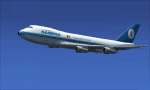
This is a repaint of the 747-129 in Sabena colors. The freeware 747-100 by Project Open Sky - POSKY is needed for this repaint. The model needed is "OS741V4_JT9D3". Sabena operated two 747-100s. They flew for the airline for many years, 1970 to 1993. Overall, they had 4 747-100s in their fleet, two of which were leased. This repaint was tested on FSX-SE, but should work on P3D v1-3 and FSX.
| Filename: | Sabena_Circa_1985_Boeing_747100.zip |
| License: | Freeware |
| Added: | 13th September 2018, 19:34:05 |
| Downloads: | 149 |
| Author: | Ted Giana |
| Size: | 7.53 MB |
| Category: Flight Simulator X - Aircraft Repaints, Textures and Modifications | |
| Transglobal Airways Douglas DC-9-30 - N930TG |
|
Images related to this file:
File Description:
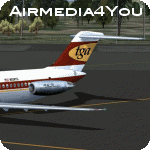
This is a new fictional retro repaint on the DC9-30 model by Stewart Global Aircraft. The model was meanwhile converted to native FSX. So it's usable in FSX and P3D. I added a modern and a retro panel. So it's up to you, to choose which one you like. Textures are saved in 32-bit. This is a complete package. Ready-to-fly. For more of my repaints visit my website: http://www.airmedia4you.de/aircraft1.html
| Filename: | Transglobal_Airways_Douglas_DC930__N930TG.zip |
| License: | Freeware |
| Added: | 16th September 2019, 16:27:56 |
| Downloads: | 216 |
| Author: | Joerg Zeitschel / SGA |
| Size: | 73.74 MB |
| Category: Flight Simulator X - Aircraft Repaints, Textures and Modifications | |
| Guyana Airways L-188C 1976 |
|
Images related to this file:
File Description:
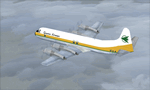
This is a repaint of an L-188C in Guyana Airways colors. The freeware L-188 by KTB is needed for this repaint. Guyana Airways leased 3 L-188Cs on short term contracts from 1975 to 1977. This particular one was leased from 1976 to 1977. Later on, in the early 1980s, they also leased an L-188A. Textures are 32bit dds. This repaint was tested on FSX-SE. It should also work on FSX, and P3D v1-3.
| Filename: | Guyana_Airways_L188C_1976.zip |
| License: | Freeware |
| Added: | 6th September 2019, 15:02:00 |
| Downloads: | 34 |
| Author: | Ted Giana |
| Size: | 9.43 MB |
| Category: Flight Simulator X - Scenery | |
| Mesh South America / MeSA E03 |
|
File Description:
FSX Mesh South America Project:
This terrain mesh file is a part of a whole project covering all the Continent
of South America and some islands, divided in tiles identified in a map by its
column (letters) and rows (numbers).
Those files were multi-LOD compiled from 90m SRTM2 source data, reprocessed
with 3DEM to remove voids and spikes, providing a 76.4m (LOD9) horizontal
resolution topography intended for use only in FSX updated with SP1.
Although not well documented, to improve performance, the updated FSX loads DEM
files in threads and only the closer terrain (about 5-10 NM from the point of view)
is rendered in high detail, while at far distances FSX shows up its default low
resolution mesh, when there is not a third part terrain mesh compiled in all
others intermediate level of details (multi-LOD).
THIS FILE:
FSX_MeSA_E03 (Column E x Row 03)
covers the area inside the boundaries:
N = 5º 37,5' N; S = 0º 0' S;
W = 60º 0' W; E = 52º 30' W;
| Filename: | Mesh_South_America__MeSA_E03.zip |
| License: | Freeware |
| Added: | 13th June 2007, 21:41:26 |
| Downloads: | 1,255 |
| Author: | Hely Heck Jr. and José Lôbo |
| Size: | 83.82 MB |
| Category: Flight Simulator X - Scenery | |
| FSX_MeSA_G08 |
|
File Description:
FSX Mesh South America Project:
This terrain mesh file is a part of a whole project covering all the Continent
of South America and some islands, divided in tiles identified in a map by its
column (letters) and rows (numbers).
Those files were multi-LOD compiled from 90m SRTM2 source data, reprocessed
with 3DEM to remove voids and spikes, providing a 76.4m (LOD9) horizontal
resolution topography intended for use only in FSX updated with SP1.
Although not well documented, to improve performance, the updated FSX loads DEM
files in threads and only the closer terrain (about 5-10 NM from the point of view)
is rendered in high detail, while at far distances FSX shows up its default low
resolution mesh, when there is not a third part terrain mesh compiled in all
others intermediate level of details (multi-LOD).
THIS FILE:
FSX_MeSA_G08 (Column G x Row 08)
covers the area inside the boundaries:
N = 22º 30' S; S = 28º 7.5' S;
W = 45º 0' W; E = 37º 30' W;
AUTHORS:
Hely Heck Junior - Magrao ( [email protected] )
and Jose Lobo ( [email protected] )
| Filename: | FSX_MeSA_G08.zip |
| License: | Freeware |
| Added: | 15th June 2007, 15:04:47 |
| Downloads: | 1,133 |
| Author: | Hely Heck Jr. and José Lôbo |
| Size: | 12 MB |
| Category: Flight Simulator X - Scenery | |
| FSX_MeSA_H04 |
|
File Description:
FSX Mesh South America Project:
This terrain mesh file is a part of a whole project covering all the Continent
of South America and some islands, divided in tiles identified in a map by its
column (letters) and rows (numbers).
Those files were multi-LOD compiled from 90m SRTM2 source data, reprocessed
with 3DEM to remove voids and spikes, providing a 76.4m (LOD9) horizontal
resolution topography intended for use only in FSX updated with SP1.
Although not well documented, to improve performance, the updated FSX loads DEM
files in threads and only the closer terrain (about 5-10 NM from the point of view)
is rendered in high detail, while at far distances FSX shows up its default low
resolution mesh, when there is not a third part terrain mesh compiled in all
others intermediate level of details (multi-LOD).
THIS FILE:
FSX_MeSA_H04 (Column H x Row 04)
covers the area inside the boundaries:
N = 0º 0' S; S = 5º 37.5' S;
W = 37º 30' W; E = 30º 0' W;
AUTHORS:
Hely Heck Junior - Magrao ( [email protected] )
and Jose Lobo ( [email protected] )
| Filename: | FSX_MeSA_H04.zip |
| License: | Freeware |
| Added: | 15th June 2007, 15:07:51 |
| Downloads: | 944 |
| Author: | Hely Heck Jr. and José Lôbo |
| Size: | 3.56 MB |
| Category: Flight Simulator X - Scenery | |
| FSX_MeSA_H05 |
|
File Description:
FSX Mesh South America Project:
This terrain mesh file is a part of a whole project covering all the Continent
of South America and some islands, divided in tiles identified in a map by its
column (letters) and rows (numbers).
Those files were multi-LOD compiled from 90m SRTM2 source data, reprocessed
with 3DEM to remove voids and spikes, providing a 76.4m (LOD9) horizontal
resolution topography intended for use only in FSX updated with SP1.
Although not well documented, to improve performance, the updated FSX loads DEM
files in threads and only the closer terrain (about 5-10 NM from the point of view)
is rendered in high detail, while at far distances FSX shows up its default low
resolution mesh, when there is not a third part terrain mesh compiled in all
others intermediate level of details (multi-LOD).
THIS FILE:
FSX_MeSA_H05 (Column H x Row 05)
covers the area inside the boundaries:
N = 5º 37.5' S; S = 11º 15' S;
W = 37º 30' W; E = 30º 0' W;
AUTHORS:
Hely Heck Junior - Magrao ( [email protected] )
and Jose Lobo ( [email protected] )
| Filename: | FSX_MeSA_H05.zip |
| License: | Freeware |
| Added: | 15th June 2007, 15:08:10 |
| Downloads: | 943 |
| Author: | Hely Heck Jr. and José Lôbo |
| Size: | 22.93 MB |
| Category: Flight Simulator X - Scenery | |
| FSX_MeSA_H06 |
|
File Description:
FSX Mesh South America Project:
This terrain mesh file is a part of a whole project covering all the Continent
of South America and some islands, divided in tiles identified in a map by its
column (letters) and rows (numbers).
Those files were multi-LOD compiled from 90m SRTM2 source data, reprocessed
with 3DEM to remove voids and spikes, providing a 76.4m (LOD9) horizontal
resolution topography intended for use only in FSX updated with SP1.
Although not well documented, to improve performance, the updated FSX loads DEM
files in threads and only the closer terrain (about 5-10 NM from the point of view)
is rendered in high detail, while at far distances FSX shows up its default low
resolution mesh, when there is not a third part terrain mesh compiled in all
others intermediate level of details (multi-LOD).
THIS FILE:
FSX_MeSA_H06 (Column H x Row 06)
covers the area inside the boundaries:
N = 11º 15' S; S = 16º 52.5' S;
W = 37º 30' W; E = 30º 0' W;
AUTHORS:
Hely Heck Junior - Magrao ( [email protected] )
and Jose Lobo ( [email protected] )
| Filename: | FSX_MeSA_H06.zip |
| License: | Freeware |
| Added: | 15th June 2007, 15:19:51 |
| Downloads: | 997 |
| Author: | Hely Heck Jr. and José Lôbo |
| Size: | 1.61 MB |
| Category: Flight Simulator X - Scenery | |
| LFLJ - Courchevel, France |
|
File Description:
This FSX scenery package contains the LFLJ Courchevel airport in the French Alps. The airport has a very short, upslope runway of only 525 m (1,722 ft). The airport is considered one of the seven most dangerous in the world. It has a difficult approach, a 300 foot upslope runway and is adjacent to the Courchevel ski runs. The Courchevel airport altitude is the highest in Europe, with a mean elevation of 6,520 feet. This airport is intended to be used with FSX and the free addon - TileProxy. TileProxy provides real-time photorealistic satellite imagery in place of the stock auto generated FSX scenery or any other scenery package. The Courchevel airport was originally released as part of an FSX airport scenery package containing 15 airports, located in the French Alps. The link to the original 15 French Alps Airport package is shown below. This file is not required, but allows you to download 15 related French Alps airports. The LFLJ, Courchevel airport in the original 15 airport package was missing a required scenery file which corrects the airport altitude (from 6420 ft. to 6520 ft.) due to the mis-location of the stock FSX airport. This download provides all three of the required .bgl scenery files.
related download:
http://library.avsim.net/search.php?SearchTerm=french+alps+airports&CatID=root&Go=Search
| Filename: | LFLJ__Courchevel_France.zip |
| License: | Freeware |
| Added: | 30th November 2013, 20:20:07 |
| Downloads: | 6,040 |
| Author: | John Greenwood |
| Size: | 655.63 KB |


© 2001-2026 AVSIM Online
All Rights Reserved
Privacy Policy |