
Where Flight Simulation Enthusiasts Gather from Around the World!
AVSIM Library - Search Results

| Category: Flight Simulator X - Aircraft Repaints, Textures and Modifications | |
| Boeing 737-790 TDS Bahamasair C6-BFA (Old Variant) |

|
Images related to this file:
File Description:
FSX/P3D TDS 737-700 Bahamasair C6-BFA. Bahamasair Holdings Limited is an airline headquartered in Nassau. It is the national airline of The Bahamas and operates scheduled services to 32 domestic and regional destinations in the Caribbean and the United States from its base at Lynden Pindling International Airport. Texture by Pharez Grant. Require TDS 737-700 Base Package. Use for PBR and Regular Version TDS 737-700
| Filename: | Boeing_737790_TDS_Bahamasair_C6BFA_Old_Variant.zip |
| License: | Freeware |
| Added: | 19th September 2022, 15:49:33 |
| Downloads: | 98 |
| Author: | P. Grant |
| Size: | 24.76 MB |
| Category: Flight Simulator X - Scenery | |
| FSX (only) SCENERY and AI for KCLT Charlotte Douglas International, NC USA |
|
Images related to this file:
File Description:

FSX (only) SCENERY and AI for KCLT Charlotte Douglas International, NC USA
Custom made terminal, hangars, buildings, ramp and street lighting, for KCLT Charlotte, NC, USA
Douglas International Airport. Includes current runway and taxiway configurations, interiors
for terminals and buildings, and a rail intermodal terminal with trains.
Textures and traffic file provided to make the new NCANG C-17s. This is a large, extensive project.
by Dan French
| Filename: | FSX_only_SCENERY_and_AI_for_KCLT_Charlotte_Douglas.zip |
| License: | Freeware, limited distribution |
| Added: | 30th December 2022, 22:28:41 |
| Downloads: | 597 |
| Author: | Dan French |
| Size: | 66.24 MB |
| Category: Flight Simulator X - AFCAD Files | |
| Australian Capital Cities & Regional Airports |
|
File Description:
This is a basic update of FSX default Australian Capital City & Regional Airports BGL airport files.
Many gates have been resized where possible to enable larger aircraft such as b747s, A380s park in the international terminals. I have also added several gates to a number of airports and assigned ATC (airline) parking codes to all the parking spots. These parking codes have been aligned to the correct terminals. Military parking spots have also been added to many airports.
Note Melbourne airport (YMML) has also been updated from my last posting.
The airports included in this pack include:
Melbourne Intl - YMML; Canberra - YSCB (includes military); Sydney Intl - YSSY; Brisbane Intl - YBBN; Darwin Intl - YPDN (includes military); Perth Intl - YPPH; Adelaide Intl - YPAD; Hobart Intl - YMHB; Albury - YMAY; Cairns Intl - YBSC; Townsville - YBTL (includes military); Gold Coast - YBCG; Launceston - YMLT; Devonport - YDPO; East Sale (Military) - YMES
These BGL AFCAD files has been tested with VOZ, PAI and RAAF AI aircraft.
There are 15 BGL AFCAD files in this download.
| Filename: | Australian_Capital_Cities__Regional_Airports.zip |
| License: | Freeware |
| Added: | 13th October 2007, 10:38:57 |
| Downloads: | 6,353 |
| Author: | Garry Appleby |
| Size: | 2.09 MB |
| Category: Flight Simulator X - Scenery | |
| Redtail Ridge Island Resort (AK94) |
|
File Description:
Redtail Ridge is a fictitious place in Alaska, but it's name is somewhat misleading as there is no ridges on the island. The airport boasts a 2300x45FT dirt runway, although it displays as a snow runway. There is also a 10000FT water runway, marked at each end with a red buoy. The airport is mainly intended as a place for the weary bush pilot to go and relax. There is a line of lakeside cabins to stay in, and there's even three little docks for floatplanes to tie up at. Also available are a selection of boats to rent, both sailboats and motorboats. For transportation around, there is a even a rental car angency. If the cabins are filled, stay in the hotel or sleep outdoors in the campsites. Go shopping at the mall or grab a bite to eat at the fast food joints. Anything you need to relax, you can find it here!
| Filename: | Redtail_Ridge_Island_Resort_AK94.zip |
| License: | Freeware |
| Added: | 2nd January 2008, 02:49:44 |
| Downloads: | 716 |
| Author: | Joe Brown |
| Size: | 5.2 KB |
| Category: Flight Simulator X - Scenery | |
| Chatham Islands for Vector Land Class New Zealand |
|
Images related to this file:
File Description:
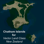
This project is a modified version of the Chatham_Islands.zip project which allows my landclass and airports to work seamlessly with the free Chatham Islands scenery available from Vector Land Class New Zealand. This package allows the user to switch back and forth easily between the different scenery combinations and also provides standalone Chatham and Pitt Island airports which can be used with the Vector Land Class (VLC) scenery on its own. It also allows the user to take advantage of the 15m terrain mesh and added water detail that comes with the VLC scenery. A modified Pitt Island AI runway is also included that is compatible with the 15m mesh. Chatham Islands/Tuuta Airport (NZCI), Napier (NZNR), and the Pitt Island Airstrip (NZPI) are included here. Scenery was created using Airport Design Editor X v1.47.07, SBuilderX 3.13, and the FSX Object Placement Tool. Scenery objects were added and modified from stock FSX scenery to resemble as closely as possible the actual airports.
| Filename: | Chatham_Islands_for_Vector_Land_Class_New_Zealand.zip |
| License: | Freeware |
| Added: | 15th July 2011, 21:54:43 |
| Downloads: | 931 |
| Author: | Carlyle Sharpe |
| Size: | 3.78 MB |
| Category: Flight Simulator X - Scenery | |
| Los Roques Archipelago and Airports |
|
Images related to this file:
File Description:
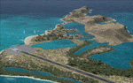
This project rebuilds Venezuela's Los Roques archipelago, adds the Gran Roque (SVRS) and Dos Mosquises (SVDM) airports, and includes AI flight plans, boat traffic, and a custom terrain mesh for Gran Roque. Accurate coastlines and lakes, as well as corrected landclass and waterclass are provided based on the latest available satellite imagery. Although current satellite imagery for this region only exists in relatively low resolution, an abundance of aerial photography was used to add custom features to Gran Roque and Dos Mosquises. Updates were created or rebuilt in a manner which carefully aligned airport data with current satellite imagery, when available. Scenery was created using Airport Design Editor X v1.50.4402, SBuilderX 3.13, and the FSX Object Placement Tool. Scenery objects were added and modified from stock FSX scenery to resemble as closely as possible the actual airports. Thank you to John Hinson and Tiago Besciak for granting permission to adapt their AI flight plans to realistically populate (SVRS) Gran Roque.
| Filename: | Los_Roques_Archipelago_and_Airports.zip |
| License: | Freeware |
| Added: | 27th July 2013, 02:34:10 |
| Downloads: | 1,396 |
| Author: | Carlyle Sharpe |
| Size: | 7.66 MB |
| Category: Flight Simulator X - Scenery | |
| CYCD (2012) Version 3 for FS9, FSX and Prepar3D |
|
Images related to this file:
File Description:
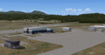
CYCD (2012) is an update to Ken Peter's CYCD Nanaimo-Collishaw Airport (Vancouver Island, British Columbia, Canada). The airport has recently completed a major runway
extension and installed an ILS for Rwy 16. The five flashing-red beacons that guide the way on a night approach to Rwy 34 are included. To the extent possible, this update
reuses Ken's custom buildings and objects (but you don't need to have Ken's version installed). As well, a selection of SAMM-generated static aircraft are scattered around the
aprons supplemented by a number of AI aircraft that do touch 'n gos from time to time. CYCD (2012) is compatible with ORBX FTX USA Canada Pacific Northwest and both versions
of Ultimate Terrain.
Generally, this new version is visually identical to its predecessor - even though quite different internally. As well, to the extent possible, it is compatible with
Prepar3Dv2. (v3.03 fixes a vehicle texture issue in 3.02)
| Filename: | CYCD_2012_Version_3_for_FS9_FSX_and_Prepar3D.zip |
| License: | Freeware |
| Added: | 22nd June 2014, 17:18:09 |
| Downloads: | 3,988 |
| Author: | Don Grovestine |
| Size: | 64 MB |
| Category: Flight Simulator X - AFCAD Files | |
| Seiser Alm STOL and Gliding Area |
|
Images related to this file:
File Description:
Seiser Alm, is the largest high altitude Alpine meadow in Europe. Located in Italy's South Tyrol province in the Dolomites mountain range, it is a major tourist attraction, known for skiing and hiking.
This is a simple fun creation of a real world R/C sailplane and Para gliding site in the Italian Dolomites. There is no airport, no flatten so you must exercise caution when landing a STOL aircraft or sailplane. I have landed many types here including sailplanes and the FSDS Porter as well as a Cessna 185. The nearest real world airport is LIPD Bolzano. There are two landing areas represented one high is the actual site where R/C sailplanes with wingspans of up to 10 meters are launched into the air, as well as paragliders. .The lower field is a bonus area with a nice flat area for easier landings and take offs. It is the real world site of a famous ski lodge and resort.(look for the Chalet!)
| Filename: | Seiser_Alm_STOL_and_Gliding_Area.zip |
| License: | Freeware |
| Added: | 4th July 2014, 05:19:40 |
| Downloads: | 161 |
| Author: | Jon Davidson |
| Size: | 75.1 KB |
| Category: Flight Simulator X - Missions | |
| Rescue Bill Bunyan |
|
File Description:
Jake, the Bold Airport (Alaska) manager just got a CB call from Bill Bunyan, master sasquatch tracker. Bill has hurt his right ankle quite seriously, and needs to by picked up by someone with a ski-equipped airplane. Your Maule is just such a plane. Bill isn't quite sure exactly where he is, but does know he's not too far from Bold Ridge. So you have one waypoint to work with. After that it's up to you. To help, Bill is burning a campfire. He says it's fairly flat at his location, but to watch out for bushes, small trees, and grizzly bears. As an experienced mountain flyer, you know that such rescues benefit from getting as much altitude as the weather allows, before getting into the mountains. Bill thinks he's in an area that's 4000 or more feet ASL, but it's snowing heavily. Don't forget to lower your skis before landing at Bill's location, and to raise them before landing back at the Airport.
| Filename: | Rescue_Bill_Bunyan.zip |
| License: | Freeware |
| Added: | 7th December 2014, 22:48:28 |
| Downloads: | 641 |
| Author: | Dan Cowan |
| Size: | 41.11 MB |
| Category: Flight Simulator X - Scenery | |
| SCIP - Isla de Pascua & Mataveri Intl - Easter Island |
|
Images related to this file:
File Description:
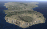
This project rebuilds Easter Island / Isla de Pascua. Mataveri Intl (SCIP) is completely overhauled, and all airport objects are aligned from satellite imagery. Landclass polygons and coastlines were meticulously hand-drawn directly from satellite imagery to provide the most detailed and accurate scenery available for this region. AI road and boat traffic is activated for the region. Accurate coastlines and road data, as well as corrected land and waterclass are provided based on the latest available satellite imagery. GA flights use default aircraft and include an option to add Chilean Air Force planes around the island. Numerous Moai (Easter Island heads) have been placed around the island according to satellite imagery. Scenery was created using Airport Design Editor X v1.61.5298, SBuilderX 3.13, and the FSX Object Placement Tool. Scenery objects were added and modified from stock FSX scenery to resemble as closely as possible the actual airports. The FSX apron lights included are from the terrific set created by Jim Dhaenens.
| Filename: | SCIP__Isla_de_Pascua__Mataveri_Intl___Easter_Islan.zip |
| License: | Freeware |
| Added: | 12th July 2014, 08:17:55 |
| Downloads: | 5,721 |
| Author: | Carlyle Sharpe |
| Size: | 5.33 MB |


© 2001-2026 AVSIM Online
All Rights Reserved
Privacy Policy |