
Where Flight Simulation Enthusiasts Gather from Around the World!
AVSIM Library - Search Results

| Category: Flight Simulator X - AFCAD Files | |
| MYGF - Grand Bahama International Airport / Freeport, Bahamas |

|
Images related to this file:
File Description:
Features:
*Accurate parking apron
*Main terminal building with parking area for commercial traffic
*Domestic terminal building
*Cargo ramp
*Separate parking area for GA traffic
*Misc airport buildings added
*Airport vehicles and objects throughout the airport
*Parking lot with vehicles
*Properly placed control tower
*Fire station
*Fuel tanks and trucks
*Rental car building with static rental vehicles
*Birds flying near runway (beware)
*Palm trees/vegetation added near terminal
(For more information on Endeavourai please visit our site at endeavourai.com or our forums at http://endeavourai.boards.net/)
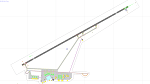
This airport update was made with the latest version of ADE (Airport Design Editor) and made for FSX as a replacement for the stock (default) airport. I've made several changes to the airport which are listed below. All these enhancements are as close to the real airport as I can get with stock library objects. I've used satellite images, terminal photos and maps throughout the whole process so building locations are as accurate as possible. Happy landings in the tropical Bahamas!
| Filename: | MYGF__Grand_Bahama_International_Airport__Freeport.zip |
| License: | Freeware |
| Added: | 12th August 2012, 05:15:17 |
| Downloads: | 952 |
| Author: | Jaison Diaz / Endeavour AI |
| Size: | 107.42 KB |
| Category: Flight Simulator X - AFCAD Files | |
| KLEX - Blue Grass Airport - Lexington, Kentucky |
|
Images related to this file:
File Description:
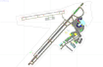
This airport update was made with the latest version of ADE (Airport Design Editor) and made for FSX as a replacement for the stock (default) airport. I've made several changes to the airport which are listed below. All these enchancements are as close to the real airport as I can get with stock library objects. I've used satellite images, terminal photos and maps throughout the whole process so building locations are as accurate as possible. Happy landings in charming Kentucky!
Features:
*Expanded parking apron
*Taxiways properly desginated
*Runway 8/26 renamed to 9/27 and moved to correct location as FSX had it completely wrong, appropriate taxiways have been repositioned and/or removed as well as per latest airport diagram
*Completely redesigned main terminal building with accurate airline assigned gates
*Seperate parking areaa for GA traffic
*Misc airport buildings added
*Airport vehicles and objects throughout the airport
*Fuel tanks and vehicles
*Fire station and vehicles
*De-icing trucks
*Static aircraft
*Autogen removed from a few areas around the airport as several buildings were popping up on airport property and a few trees were too close to runway
| Filename: | KLEX__Blue_Grass_Airport__Lexington_Kentucky.zip |
| License: | Freeware |
| Added: | 22nd December 2012, 00:03:01 |
| Downloads: | 598 |
| Author: | Jaison Diaz / Endeavour ai |
| Size: | 153.05 KB |
| Category: Flight Simulator X - Scenery | |
| Mesh South America / MeSA B09 |
|
File Description:
FSX Mesh South America Project:
This terrain mesh file is a part of a whole project covering all the Continent of South America and some islands, divided in tiles identified in a map by its column (letters) and rows (numbers).
Those files were multi-LOD compiled from 90m SRTM2 source data, reprocessed with 3DEM to remove voids and spikes, providing a 76.4m (LOD9) horizontal resolution topography intended for use only in FSX updated with SP1.
Although not well documented, to improve performance, the updated FSX loads DEM files in threads and only the closer terrain (about 5-10 NM from the point of view) is rendered in high detail, while at far distances FSX shows up its default low resolution mesh, when there is not a third part terrain mesh compiled in all others intermediate level of details (multi-LOD).
THIS FILE:
FSX_MeSA_B09 (Column B x Row 09
covers the area inside the boundaries:
N = 33º 45' S; S = 39º 22,5' S;
W = 82º 30' W; E = 75º 0' W;
AUTHORS:
Hely Heck Junior - Magrao ( [email protected] )
and Jose Lobo ( [email protected] )
TerraBrasilis: www.terra-brasilis.org
| Filename: | Mesh_South_America__MeSA_B09.zip |
| License: | Freeware |
| Added: | 11th June 2007, 22:11:00 |
| Downloads: | 1,195 |
| Author: | Hely Heck Jr. and José Lôbo |
| Size: | 1.53 MB |
| Category: Flight Simulator X - Scenery | |
| Mesh South America / MeSA B08 |
|
File Description:
FSX Mesh South America Project:
This terrain mesh file is a part of a whole project covering all the Continent of South America and some islands, divided in tiles identified in a map by its column (letters) and rows (numbers).
Those files were multi-LOD compiled from 90m SRTM2 source data, reprocessed with 3DEM to remove voids and spikes, providing a 76.4m (LOD9) horizontal resolution topography intended for use only in FSX updated with SP1.
Although not well documented, to improve performance, the updated FSX loads DEM files in threads and only the closer terrain (about 5-10 NM from the point of view) is rendered in high detail, while at far distances FSX shows up its default low resolution mesh, when there is not a third part terrain mesh compiled in all
others intermediate level of details (multi-LOD).
THIS FILE:
FSX_MeSA_B08 (Column B x Row 08)
This file covers the area inside the boundaries:
N = 22º 30' S; S = 28º 7,5' S;
W = 82º 30' W; E = 75º 0' W;
AUTHORS:
Hely Heck Junior - Magrao ( [email protected] )
and Jose Lobo ( [email protected] )
TerraBrasilis: www.terra-brasilis.org
| Filename: | Mesh_South_America__MeSA_B08.zip |
| License: | Freeware |
| Added: | 11th June 2007, 22:10:37 |
| Downloads: | 1,208 |
| Author: | Hely Heck Jr. and José Lôbo |
| Size: | 1.51 MB |
| Category: Flight Simulator X - Scenery | |
| Mesh South America / MeSA B01 |
|
File Description:
FSX Mesh South America Project:
This terrain mesh file is a part of a whole project covering all the Continent of South America and some islands, divided in tiles identified in a map by its column (letters) and rows (numbers).
Those files were multi-LOD compiled from 90m SRTM2 source data, reprocessed with 3DEM to remove voids and spikes, providing a 76.4m (LOD9) horizontal resolution topography intended for use only in FSX updated with SP1.
Although not well documented, to improve performance, the updated FSX loads DEM files in threads and only the closer terrain (about 5-10 NM from the point of view) is rendered in high detail, while at far distances FSX shows up its default low resolution mesh, when there is not a third part terrain mesh compiled in all others intermediate level of details (multi-LOD).
THIS FILE: FSX_MeSA_B01 (Column B x Row 01)
This file covers the area inside the boundaries:
N = 16º 52,5' N; S = 11º 15' N;
W = 82º 30' W; E = 75º 0' W;
AUTHORS:
Hely Heck Junior - Magrao ( [email protected] )
and Jose Lobo ( [email protected] )
TerraBrasilis: www.terra-brasilis.org
| Filename: | Mesh_South_America__MeSA_B01.zip |
| License: | Freeware |
| Added: | 11th June 2007, 15:56:55 |
| Downloads: | 1,400 |
| Author: | Hely Heck Jr. and José Lôbo |
| Size: | 1.53 MB |
| Category: Flight Simulator X - Scenery | |
| Mesh South America / MeSA A01 |
|
File Description:
FSX Mesh South America Project:
This terrain mesh file is a part of a whole project covering all the Continent of South America and some islands, divided in tiles identified in a map by its column (letters) and rows (numbers).
Those files were multi-LOD compiled from 90m SRTM2 source data, reprocessed with 3DEM to remove voids and spikes, providing a 76.4m (LOD9) horizontal resolution topography intended for use only in FSX updated with SP1.
Although not well documented, to improve performance, the updated FSX loads DEM files in threads and only the closer terrain (about 5 NM from the point of view)is rendered in high detail, while at far distances FSX shows up its default low resolution mesh, when there is not a third part terrain mesh compiled in all others intermediate level of details (multi-LOD).
THIS FILE: FSX_MeSA_A01
(Column A x Row 01)
This file covers the area inside the boundaries:
N = 16º 52,5' N; S = 11º 15' N;
W = 90º 0' W; E = 82º 30' W;
AUTHORS:
Hely Heck Junior - Magrao ( [email protected] )
and Jose Lobo ( [email protected] )
TerraBrasilis: www.terra-brasilis.org
| Filename: | Mesh_South_America__MeSA_A01.zip |
| License: | Freeware |
| Added: | 11th June 2007, 00:03:00 |
| Downloads: | 1,958 |
| Author: | Hely Heck Jr. and José Lôbo |
| Size: | 49.55 MB |
| Category: Flight Simulator X - Scenery | |
| Mesh South America / MeSA A03 |
|
File Description:
FSX Mesh South America Project:
This terrain mesh file is a part of a whole project covering all the Continent of South America and some islands, divided in tiles identified in a map by its column (letters) and rows (numbers).
Those files were multi-LOD compiled from 90m SRTM2 source data, reprocessed with 3DEM to remove voids and spikes, providing a 76.4m (LOD9) horizontal resolution topography intended for use only in FSX updated with SP1.
Although not well documented, to improve performance, the updated FSX loads DEM files in threads and only the closer terrain (about 5 NM from the point of view) is rendered in high detail, while at far distances FSX shows up its default low resolution mesh, when there is not a third part terrain mesh compiled in all others intermediate level of details (multi-LOD).
THIS FILE:
FSX_MeSA_A03
Column A x Row 03
This file covers the area inside the boundaries:
N = 5º 37,5' N; S = 0º 0' S;
W = 90º 0' W; E = 82º 30' W;
AUTHORS:
Hely Heck Junior - Magrao ( [email protected] )
and José Lôbo ( [email protected] )
TerraBrasilis: www.terra-brasilis.org
| Filename: | Mesh_South_America__MeSA_A03.zip |
| License: | Freeware |
| Added: | 11th June 2007, 00:02:40 |
| Downloads: | 1,419 |
| Author: | Hely Heck Jr. and José Lôbo |
| Size: | 1.52 MB |
| Category: Flight Simulator X - Scenery | |
| Mesh South America / MeSA B06 |
|
File Description:
FSX Mesh South America Project:
This terrain mesh file is a part of a whole project covering all the Continent of South America and some islands, divided in tiles identified in a map by its column (letters) and rows (numbers).
Those files were multi-LOD compiled from 90m SRTM2 source data, reprocessed with 3DEM to remove voids and spikes, providing a 76.4m (LOD9) horizontal resolution topography intended for use only in FSX updated with SP1.
Although not well documented, to improve performance, the updated FSX loads DEM files in threads and only the closer terrain (about 5-10 NM from the point of view) is rendered in high detail, while at far distances FSX shows up its default low resolution mesh, when there is not a third part terrain mesh compiled in all others intermediate level of details (multi-LOD).
THIS FILE:
FSX_MeSA_B06 (Column B x Row 06)
This file covers the area inside the boundaries:
N = 11º 15' S; S = 16º 52,5' S;
W = 82º 30' W; E = 75º 0' W;
AUTHORS:
Hely Heck Junior - Magrao ( [email protected] )
and Jose Lobo ( [email protected] )
TerraBrasilis: www.terra-brasilis.org
| Filename: | Mesh_South_America__MeSA_B06.zip |
| License: | Freeware |
| Added: | 11th June 2007, 22:10:10 |
| Downloads: | 1,422 |
| Author: | Hely Heck Jr. and José Lôbo |
| Size: | 12.99 MB |
| Category: Flight Simulator X - Scenery | |
| Mesh South America / MeSA D09 |
|
File Description:
FSX Mesh South America Project:
This terrain mesh file is a part of a whole project covering all the Continent
of South America and some islands, divided in tiles identified in a map by its
column (letters) and rows (numbers).
Those files were multi-LOD compiled from 90m SRTM2 source data, reprocessed
with 3DEM to remove voids and spikes, providing a 76.4m (LOD9) horizontal
resolution topography intended for use only in FSX updated with SP1.
Although not well documented, to improve performance, the updated FSX loads DEM
files in threads and only the closer terrain (about 5-10 NM from the point of view)
is rendered in high detail, while at far distances FSX shows up its default low
resolution mesh, when there is not a third part terrain mesh compiled in all
others intermediate level of details (multi-LOD).
THIS FILE:
FSX_MeSA_D09 (Column D x Row 09)
covers the area inside the boundaries:
N = 33º 45' S; S = 39º 22.5' S;
W = 67º 30' W; E = 60º 0' W;
AUTHORS:
Hely Heck Junior - Magrao ( [email protected] )
and Jose Lobo ( [email protected] )
TerraBrasilis: www.terra-brasilis.org
| Filename: | Mesh_South_America__MeSA_D09.zip |
| License: | Freeware |
| Added: | 13th June 2007, 12:36:59 |
| Downloads: | 1,259 |
| Author: | Hely Heck Jr. and José Lôbo |
| Size: | 52.3 MB |
| Category: Flight Simulator X - Scenery | |
| Mesh South America / MeSA D13 |
|
File Description:
FSX Mesh South America Project:
This terrain mesh file is a part of a whole project covering all the Continent
of South America and some islands, divided in tiles identified in a map by its
column (letters) and rows (numbers).
Those files were multi-LOD compiled from 90m SRTM2 source data, reprocessed
with 3DEM to remove voids and spikes, providing a 76.4m (LOD9) horizontal
resolution topography intended for use only in FSX updated with SP1.
Although not well documented, to improve performance, the updated FSX loads DEM
files in threads and only the closer terrain (about 5-10 NM from the point of view)
is rendered in high detail, while at far distances FSX shows up its default low
resolution mesh, when there is not a third part terrain mesh compiled in all
others intermediate level of details (multi-LOD).
THIS FILE:
FSX_MeSA_D13 (Column D x Row 13)
covers the area inside the boundaries:
N = 50º 37.5' S; S = 56º 15' S;
W = 67º 30' W; E = 60º 0' W;
AUTHORS:
Hely Heck Junior - Magrao ( [email protected] )
and Jose Lobo ( [email protected] )
TerraBrasilis: www.terra-brasilis.org
| Filename: | Mesh_South_America__MeSA_D13.zip |
| License: | Freeware |
| Added: | 13th June 2007, 16:38:14 |
| Downloads: | 1,124 |
| Author: | Hely Heck Jr. and José Lôbo |
| Size: | 4.79 MB |
© 2001-2026 AVSIM Online
All Rights Reserved
Privacy Policy |