
Where Flight Simulation Enthusiasts Gather from Around the World!
AVSIM Library - Search Results

| Category: Flight Simulator X - AFCAD Files | |
| TISX - Henry E. Rohlsen Airport / Christiansted, St. Croix, US Virgin Islands |

|
Images related to this file:
File Description:
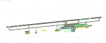
TISX - Henry E. Rohlsen Airport / Christiansted, St. Croix, USVI
This airport update was made with the latest version of ADE (Airport Design Editor) and made for FSX as a replacement for the stock (default) airport. I've made several changes to the airport which are listed below. All these enchancements are as close to the real airport as I can get with stock library objects. I've used satellite images, terminal photos and maps throughout the whole process so building locations are as accurate as possible. Happy landings in the serene United States Virgin Islands!
Features:
Expanded parking apron, Main terminal building with parking area for commercial traffic
Seperate parking area for GA traffic, Misc airport buildings added
Airport vehicles and objects throughout the airport, Fuel tanks and vehicles
Coconut trees, Expanded runway as per latest charts
Expanded taxiways as per latest charts, Military cargo area
Commercial cargo area
| Filename: | TISX__Henry_E_Rohlsen_Airport__Christiansted_St_Cr.zip |
| License: | Freeware |
| Added: | 23rd October 2012, 18:37:47 |
| Downloads: | 786 |
| Author: | Jaison Diaz / Endeavour AI |
| Size: | 109.69 KB |
| Category: Flight Simulator X - Scenery | |
| PN40 - (Moorhead Airpark - Home of the Erie Skydivers) |
|
File Description:
This is an improvement of what came with the default scenery in FSX for PN40. I have removed the dafault hangar and added two custom hangars using photo textures that are on the airport. The third hangar is one that comes with FSX. Added the peas that the skydivers use as a target when they jump. Replaced the default boundary and roads in the area surrounding the airport. Added the woods that are around the airort using SbuilderX. Also added the split rail fence using SbuilderX.
| Filename: | PN40__Moorhead_Airpark__Home_of_the_Erie_Skydivers.zip |
| License: | Freeware |
| Added: | 21st October 2007, 23:53:58 |
| Downloads: | 513 |
| Author: | Bill Good |
| Size: | 497.29 KB |
| Category: Flight Simulator X - Scenery | |
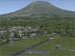
| Botswana Airports (115 airports across Botswana) |
|
Images related to this file:
File Description:
This pack contains 115 airports for Botswana, including all the majors (with recent runway extensions and so forth, as per information available on the web, via NOTAM, etc.), plus many bush strips from across the country. It also contains various other features, such as details at some of the major mines, Sua Pan salt drying area, and minor roads around the airports. All were designed with ADE X v1.5, and tested in FSX SP2. They are designed to go with Aeroworx's excellent Southern Africa scenery (see readme).
| Filename: | Botswana_Airports_115_airports_across_Botswana.zip |
| License: | Freeware |
| Added: | 20th April 2012, 20:39:45 |
| Downloads: | 2,658 |
| Author: | David Atkinson |
| Size: | 269.87 KB |
| Category: Flight Simulator X - Scenery | |
| KSAN - San Diego Intl Airport - California, USA *Update* |
|
Images related to this file:
File Description:
This airport update is made only for FSX: Terminal 2 extension updated, assigned parking as per their website with extra parking, taxiways and taxi signs updated to the latest charts, the Missed Approach leg for 09 ILS now corrected from "SARGS" to "CAPUS", PAPI added to 09, general aviation area updated and buildings replaced, extra fuel trucks, support vehicle roads rebuilt and many other scenery improvements, airport views are from the roof of the control tower (when in tower view) please view the readme before installation.
| Filename: | KSAN__San_Diego_Intl_Airport__California_USA_Updat.zip |
| License: | Freeware, limited distribution |
| Added: | 6th January 2016, 15:14:49 |
| Downloads: | 44,377 |
| Author: | Ray Smith |
| Size: | 1.71 MB |
| Category: Flight Simulator X - Scenery | |
| CYSG - St. Georges Aerodrome - Quebec, Canada - v1.2 |
|
Images related to this file:
File Description:
Saint-Georges Aerodrome, (ICAO: CYSG), is a general aviation aerodrome located 1.5 nautical miles (2.8 km; 1.7 mi) west-southwest of Saint-Georges, Quebec, Canada near the border with Maine. The airport has a long, paved runway, suitable for use by jets. This scenery FSX and P3D Airport St-Georges was inspired by the great FS2004 scenery of the late pilot Virtual Hugues Caron img12. It was made very humbly in his memory. This scenery been validated and tested with FSX SP1, SP2, Acceleration and P3D v2. This is a complete reproduction, more accurate and realistic in Saint-Georges Beauce airport with all the buildings around it. For technical information or assistance contact one of the following email addresses support: [email protected] or [email protected]. Web site : http://imaginairvirtuel.qc.ca
In addition to compatibility P3D added, version 1.2 will replace and improve version 1.1. It is suggested to uninstall version 1.1 and replace it.
| Filename: | CYSG__St_Georges_Aerodrome__Quebec_Canada__v12.zip |
| License: | Freeware, limited distribution |
| Added: | 8th March 2015, 22:27:34 |
| Downloads: | 1,416 |
| Author: | Georges Bourgouin |
| Size: | 7.67 MB |
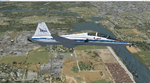
| Category: Flight Simulator X - Original Aircraft | |
| Air Canada CSeries 300 V4 |
|
Images related to this file:
File Description:

FSX Air Canada CSeries 300 V4. This version 4, features more improved and detailed aircraft model and textures , including CamSim's own static displays and Animated Ground Servicing (AGS).
Model design and paint by Camil Valiquette.
| Filename: | Air_Canada_CSeries_300_V4.zip |
| License: | Freeware |
| Added: | 19th February 2016, 09:09:34 |
| Downloads: | 538 |
| Author: | Camil Valiquette |
| Size: | 4.81 MB |
| Category: Flight Simulator X - AI Aircraft | |
| Air Canada Boeing 787-8 |
|
Images related to this file:
File Description:

FSX CamSim AI Aircraft, Boeing 787-8 Air Canada, textures only, to be used with CamSim AI Aircraft Base Model files package available separately: camsim788ai_x.zip for AI traffic.
Model design and paint by Camil Valiquette.
| Filename: | Air_Canada_Boeing_7878.zip |
| License: | Freeware |
| Added: | 5th November 2014, 20:14:46 |
| Downloads: | 563 |
| Author: | Camil Valiquette |
| Size: | 522.19 KB |
| Category: Flight Simulator X - Scenery | |
| Goma Intl (FZNA) DRC and Gisenyi (HRYG) Rwanda |
|
Images related to this file:
File Description:
This project includes the neighboring Goma Intl (FZNA) and Gisenyi (HRYG) airports. After Goma's only runway was severely damaged by the eruption of Mount Nyiragongo in 2002, the runway, originally 3000m long, was reduced to 1800m of serviceable pavement after lava flowed onto the northern part runway and through the city center. In 2013, German NGO Welthungerhilfe ("World Hunger Aid") signed a contract to rehabilitate 500m of runway damaged by the lava flow. Goma resumed scheduled international flights in 2015, and this project reflects the airport as of March 2016, with runway 18/36 renumbered to 17/35. SRTMGL1 (30m) mesh brings the volcanoes in the area into much greater detail. This scenery is complimented by the Kigali Intl (HRYR) scenery (FSX_HRYR_Kigali_2016.zip).
Updates were created or rebuilt in a manner which carefully aligns airport data with current satellite imagery. Scenery was created using Airport Design Editor X v1.70.6042, SBuilderX 3.13, and the FSX Object Placement Tool. Scenery objects were added and modified from stock FSX scenery to resemble as closely as possible the actual airports. The FSX apron lights included are from the set created by Jim Dhaenens.
| Filename: | Goma_Intl_FZNA_DRC_and_Gisenyi_HRYG_Rwanda.zip |
| License: | Freeware |
| Added: | 4th August 2016, 21:11:20 |
| Downloads: | 2,276 |
| Author: | Carlyle Sharpe |
| Size: | 5.25 MB |
| Category: Flight Simulator X - Scenery | |
| MIAMI CITY X DEMO |
|
Images related to this file:
File Description:

MIAMI CITY X DEMO features an extremely detailed scenery of Miami City in Florida, United States, fully compatible with FSX/FSX:SE/P3Dv1/P3Dv2/P3Dv3/P3Dv4 and FSW by Dovetail.
This Demo version of the commercial product is a fully functional freeware scenery, perfectly aligned with the full payware version. This ensures no problems with online (VATSIM, IVAO and multiplayer) flying in case some users have the payware scenery and some don't. The demo gives a few downtown buildings and AFCAD files for KMIA, KTMB and KOPF airports.
Miami is a city located on the Atlantic coast in southeastern Florida and the county seat of Miami-Dade County. This product gives you the possibility to fly over a very large area of Miami City, with ground, autogen, hundrieds of custom-made photoreal buildings, including lite sceneries of KMIA, KTMB and KOPF airports.
It's equipped with an automatic installer, which means that the scenery will be automatically added to the Flight Simulator Scenery Library.
Please uninstall all previous versions of this airport you may have installed before. Please make also sure that no duplicated AFCAD files are installed.
Enjoy your virtual flying with Drzewiecki Design!
| Filename: | MIAMI_CITY_X_DEMO.zip |
| License: | Freeware, limited distribution |
| Added: | 23rd August 2017, 01:36:12 |
| Downloads: | 1,665 |
| Author: | Drzewiecki Design |
| Size: | 15.39 MB |
| Category: Flight Simulator X - Scenery Design | |
| (Version 2.0) KEFD -Ellington 2025 Refresh FSX (Circa 2006-2010)- Johnson Space Center Houston |
|
Images related to this file:
File Description:
Version 2.0 covers landclass across the entire greater Houston area, with a large increase in LOD. This version significantly tightens up and improves the landclass from version 1.0, and adds a vast amount of scenery objects that brings the Bay Area-KEFD area into the modern era. This improves and adds a highly accurate runway 17 approach with accurate placement of buildings and scenery around the year 2011-modern day. In addition, includes several new files including a new airport/helipad via Houston Clear lake regional airport, T41 La Porte Municipal and surrounding shipping ports, Kemah Boardwalk, and a giant improvement to Johnson Space Center Houston. Rundway 35 and Runway 22 landclass is significantly increased, and more accurate as well. You can fly an accurate VFR approach or set up an ILS for any one of KEFD's runways with ease with this improvement.List of Version 2.0 additions and changes: - I added a ton of scenery objects and tightened up the landclass at Johnson Space Center Houston- NASA Control Center--- Added Talon Park with T38s (via static objects)--- Added Gemeni V rocket and 747 for the shuttle transporter--- And a whole bunch of vegetation, new buildings, and tour buses.- Added Kemah boardwalk and several boat docks- Removed a TON of highrise textures and replaced with medium and large city suburb landclass.- Added Clear Lake regional Hospital with helipad and surrounding scenery by Walter Reed Park- Added El Jardin or "Bayport Container port" with several scenery objects and significantly tightened up landclass.-- Looks great when setting up ILS approach for RWY 22- Tightened up Bay Area BLVD landclass, "adding" University of Houston Clear Lake"-- UHCL was semi already present, just made it more pronounced.- Made Red Bluff road landclass super recognizable!-- Red Bluff road is used to set up VFR approach and or field break for RWY 22 and RWY 17 R.----- Its common to see private jets and the USAF doing a break along Red Bluff road.- Added First Baptist Church, and water tower to Pasadena Convention center- Made Fairmont Parkway pronounced with landclass- Added Houston Port Authority at Morgan's Point--- Another Landmark for the RWY 22 ILS approach, NASA religiously uses this to line up the 10 mile ILS.- Tightened up landclass at Village Grove East and along Fairmont Parkway- Added a TON of scenery objects and landclass corrections for approach of RWY 17 L and 17 R.---- Added Home Depot, Lowes, Walmart Super center, Guitar center etc.---- added South Main Baptist Church--- Bondy Jr High, Turner Elementary, and Pasadena Memorial High School--- Added Saint Luke's Hospital--- Added Hampton Inn Suites and HCA rehab hospital--- Added a ton to the container facility behind best buy and storage facility--- Added smaller churches on RWY 17 approach--- Added a ton of scenery at the base of RWY 17 R, i.e., concrete plant, containers, trucks-- Added gas stations on the corner of beltway 8 and genoa red bluff-- Significantly changed and tightened up landclass at the base of RWY 22 and RWY 17 L and 17 R-- Made several roads and Beltway pronounced------ This decision looks AWESOME at night, really adds demarcation to the roads.**All of this makes the RWY 17 approach super recognizable** RWY 22 approach landclass is much more accurate.- Significantly changed and tightened up landclass near southbelt ellington and interstate 45.- Added Grace Church-- I wanted to do San Jacinto College south, but seemed over kill at that point.- SIGNIFICANTLY tightened up landclass for RWY 35 approach and near baybrook mall.-- Along I45- Added TDECU stadium at the University of Houston Main Campus---- So you can practice flybys for Cougar games!- Added the Battleship at San Jacinto Monument- I also "borrowed" T41 La Porte Municipal's tower camera to make a SWEET view of KEFD.- I included landclass for Sealy Texas this time, as well as my significant enhancements of Austin, Texas greater area as well (optional, but recommended!)---------------------------------------------------------------------------Version 1.0 originally added:- Added the Johnson Space Center Houston, which is now greatly enhanced and blended.- San Jacinto Community College-Central- Pasadena Convention Center- Pasadena Water Treatment Facility- NASA Bouncy Lab- Pasadena Shopping center, now greatly enhanced and blended.- Baybrook Mall and other shopping spots.- Significant Landclass improvements across the entire greater Houston Area File also includes landclass and scenery improvements for the greater Austin, Texas Area (optional), KIAH, KDWH, and Sealy, Texas. Each of these projects combined covers roughly 15,000 square miles of landclass improvement. Allowing you to fly entirely from Houston to Austin, or Houston to San Antonio in accurate landclass. -Enjoy!DJN
| Filename: | Version_20_KEFD_Ellington_2025_Refresh_FSX_Circa_2.zip |
| License: | Freeware |
| Added: | 12th October 2025, 16:15:47 |
| Downloads: | 66 |
| Author: | Dan Nelson |
| Size: | 277.28 MB |
© 2001-2026 AVSIM Online
All Rights Reserved
Privacy Policy |