
Where Flight Simulation Enthusiasts Gather from Around the World!
AVSIM Library - Search Results

| Category: Flight Simulator X - Original Aircraft | |
| Project Rhino 58 FSX |

|
File Description:
FSX Project Rhino 58: Airport Fire Rescue Truck with Virtual Cockpit I build 4 Versions a German, US, CANADA and one for the AIRFORCE, you find it under Aircraft "FTBVA".
| Filename: | Project_Rhino_58_FSX.zip |
| License: | Freeware |
| Added: | 18th October 2008, 01:16:40 |
| Downloads: | 2,374 |
| Author: | Dirk Stuck |
| Size: | 10.34 MB |
| Category: Flight Simulator X - AI Flight Plans | |
| Air Transat Winter 2018 Flight Plans |
|
Images related to this file:
File Description:

Air Transat Winter 2018 flightplans. Data taken from the week of February 18-24, includes 592 flights per week to 60 destinations in Canada, USA, Caribbean, South America and Europe.
| Filename: | Air_Transat_Winter_2018_Flight_Plans.zip |
| License: | Freeware |
| Added: | 20th March 2018, 16:43:56 |
| Downloads: | 459 |
| Author: | Ryan O'Reilly |
| Size: | 103.7 KB |
| Category: Flight Simulator X - Missions | |
| KulusukMedicalSupplies.zip |
|
File Description:
Helicopter mission. A helicopter stationed at BGKK airport provides services. Deliver medical supplies to four villages in the Kulusuk area of Greenland.
| Filename: | KulusukMedicalSupplieszip.zip |
| License: | Freeware |
| Added: | 16th March 2024, 20:11:43 |
| Downloads: | 41 |
| Author: | helomissionman |
| Size: | 4.82 MB |
| Category: Flight Simulator X - Scenery | |
| 9A3 - Chuathbaluk Airport - Alaska |
|
File Description:
Chuathbaluk Airport (IATA: CHU, ICAO: PACH, FAA LID: 9A3) is a state-owned public-use airport located one nautical mile (1.85 km) northeast of the central business district of Chuathbaluk, a city in the Bethel Area of Alaska.
All changes made were based on 2007 construction plans.
Added runway threshold (REIL) lights. Taxiway, aprons, parking area and custom buildings.
| Filename: | 9A3__Chuathbaluk_Airport__Alaska.zip |
| License: | Freeware |
| Added: | 10th February 2013, 17:31:48 |
| Downloads: | 1,198 |
| Author: | Wayne Roberts |
| Size: | 11 MB |
| Category: Flight Simulator X - Scenery | |
| Extreme Westgreenland |
|
File Description:
Extreme Westgreenland
Terrain Mesh for Greenland for Microsoft Flight Simulator X
Everybody who flies in Greenland knows, how incorrect the default scenery is.
This is a new terrain mesh scenery which covers Westgreenland - from Lat N 65 to N 68.
As SRTM data do not cover above N 60 - no Greenland mesh scenery has been produced.
This is one of the most detailed Greenland terrain mesh released up to release date of this scenery.
This great package covers more than 50.000 sq. km. area. This includes:
* LOD11 Mesh (terrain/elevation)
* Redesigned coastline
* Redesign lakes
R E S O U R C E S
Flightsim.gl sceneries for Microsoft Flight Simulator
http://www.flightsim.gl
Flightsim.gl updates, support and official website
http://www.flightsim.gl
N O T E S
This product including all files contained within this package is copyright © Flightsim.gl (www.flightsim.gl).
The information provided within this document and the Flightsim.gl Extreme Westgreenland scenery package is
not intended for real world navigation. All trademarks and/or logos mentioned and/or displayed within this
scenery package are property of their respective holders and are being used solely with the purpose of
representing reality.
| Filename: | Extreme_Westgreenland.zip |
| License: | Freeware, limited distribution |
| Added: | 22nd December 2007, 01:31:21 |
| Downloads: | 3,669 |
| Author: | Ulrik Motzfeldt |
| Size: | 44.95 MB |
| Category: Flight Simulator X - Scenery | |
| East Coast Victoria YLKE Lakes Entrance YGRL Great Lakes Airport YORB Orbost YMCO Mallacoota |
|
Images related to this file:
File Description:
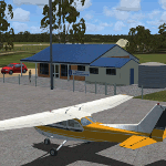
There are 4 airports. YLKE Lakes Entrance YGRL Great Lakes Airport YORB Orbost YMCO Mallacoota. A few airports but this is no quicky slap dash effort but hundred+ hours. Surrounding scenery modified to match real life. Towns have been added or shifted. Forests cut down or added. Sewage treatment ponds and other stuff added. Included is an AI traffic files that covers the airports. These files are for Flight Simulator X. Made using Airport Design Editor using some objects borrowed from Robert Budd's excellent Baccus Marsh. RECOMMENDED The scenery is designed to interface with ORBX FTX_AU scenery for Australia (payware). It will work without ORBX but will not interface as well with standard scenery.
| Filename: | East_Coast_Victoria____YLKE_Lakes_Entrance_YGRL_Gr.zip |
| License: | Freeware |
| Added: | 1st September 2019, 08:19:08 |
| Downloads: | 251 |
| Author: | Colin Jeffery |
| Size: | 6.31 MB |
| Category: Flight Simulator X - AFCAD Files | |
| Malone Airport (NJ61), NJ |
|
File Description:
Located 02 miles E of Frenchtown, New Jersey on 45 acres of land, Malone is a private airport with two turf strips, the longest of which is 2400' in length. There are no services offered, although there is room next to the existing planes to park if you wish - collisions are disabled with the aircraft. Both runways have their hard surfaces removed so turn your mesh settings as high as possible. Both runways slope down from the hangar/house area. Airport is unlit and daytime VFR operations only are recommended.
Scenery constructed with use of satellite images/streetview/aerial photos - the author has not been there in person.
This scenery is meant to be used in conjunction with MegaScenery Earth New York 007. It is not required, but apron use is minimized to allow satellite scenery to show through as much as possible, and objects are placed based on the MSE textures - lack of it may make scenery look out of place.
| Filename: | Malone_Airport_NJ61_NJ.zip |
| License: | Freeware |
| Added: | 20th September 2011, 13:57:18 |
| Downloads: | 284 |
| Author: | Drew Sikora |
| Size: | 958.34 KB |
| Category: Flight Simulator X - AFCAD Files | |
| Air-List-Ads Airport (JY07), NJ |
|
File Description:
This is a small turf strip 1500x70 feet located near the border of NJ and PA in the northwestern part of the state. It's not officially listed so I don't have any more data than that. No services of any kind are available. Trees are summer ONLY. If you fly VFR around the area, this will at least prevent you from seeing a random-looking grass strip over some trees and half a neighborhood. Runway headings are 11/29
Scenery constructed with use of satellite images/streetview, the author has not been there in person.
This scenery is meant to be used in conjunction with MegaScenery Earth New York 007. It is not required, but apron use is minimized to allow satellite scenery to show through as much as possible, and objects are placed based on the MSE textures - lack of it may make scenery look out of place.
| Filename: | AirListAds_Airport_JY07_NJ.zip |
| License: | Freeware |
| Added: | 16th October 2010, 08:57:57 |
| Downloads: | 182 |
| Author: | Drew Sikora |
| Size: | 283.7 KB |
| Category: Flight Simulator X - Aircraft Repaints, Textures and Modifications | |
| Air Canada Boeing 737-500 Star Alliance |
|
File Description:
Textures re-done and improved!!
Textures only for Wilco/Feelthere's 737PIC basepack,winzip and notepad required..
Air Canada in Star Alliance livery for 737PIC..
Tried and tested in FSX and FS2004
| Filename: | Air_Canada_Boeing_737500_Star_Alliance.zip |
| License: | Freeware |
| Added: | 1st August 2011, 22:50:52 |
| Downloads: | 365 |
| Author: | Dave Leesley |
| Size: | 4 MB |
| Category: Flight Simulator X - Aircraft Repaints, Textures and Modifications | |
| Convair R3Y Tradewind |
|
Images related to this file:
File Description:

Original Payware Convair R3Y Tradewind required from Virtavia. This is a fictitious "what if" Forest Industries Flying Tanker (FIFT) based out of Sproat Lake, British Columbia, Canada. Tested in FSX Acceleration.
| Filename: | Convair_R3Y_Tradewind.zip |
| License: | Freeware |
| Added: | 4th May 2015, 09:03:57 |
| Downloads: | 136 |
| Author: | Tommy Mitomi |
| Size: | 18.98 MB |


© 2001-2026 AVSIM Online
All Rights Reserved
Privacy Policy |