
Where Flight Simulation Enthusiasts Gather from Around the World!
AVSIM Library - Search Results

| Category: Flight Simulator X - Scenery | |
| HEBA - Borg El Arab Intl - Alexandria, Egypt *v2.0* |

|
Images related to this file:
File Description:
Version 2.0. P3D v2 compatible. A close to reality scenery with the new terminal building designed with Google SketchUp8. Designed using ADEX.
Features:
-New glass terminal with jetways.
-Stand numbers and accurate stand coordination.
-Apron Lighting.
Please read the README file before install. Compatible with both FSX and P3D.
| Filename: | HEBA__Borg_El_Arab_Intl__Alexandria_Egypt_v20.zip |
| License: | Freeware, limited distribution |
| Added: | 22nd September 2015, 20:01:25 |
| Downloads: | 5,150 |
| Author: | Ahmed Abdessalam |
| Size: | 6.09 MB |
| Category: Flight Simulator X - Scenery | |
| Batajnica Air Base (LYBT) |
|
Images related to this file:
File Description:

This is a scenery package of Batajnica airforce base in Serbia. It is situated between the towns of Batajnica and Nova Pazova, it has 2 concrete runways and it is the largest airport in former SFR Yugoslavia. It is a 80% realistic representation of the airport complete with photoreal ground textures. Please see included readme file for details.
| Filename: | Batajnica_Air_Base_LYBT.zip |
| License: | Freeware |
| Added: | 26th January 2014, 13:34:48 |
| Downloads: | 1,389 |
| Author: | Vladimir Levkov, Nenad Djurdjev |
| Size: | 35.98 MB |
| Category: Flight Simulator X - Scenery | |
| UK Channel Islands X-HD Bundle |
|
Images related to this file:
File Description:

The English channel aslands are located just off the coast of Northern France, they are made up of Jersey Alderney and Guernsey. This is the bundle of all 3 islands. Included are EGJJ, EGJB and EGJA all in beautiful HD and Alderney is in full photo scenery.
For more information please see here: http://www.soarflyconcepts.com/channel
| Filename: | UK_Channel_Islands_XHD_Bundle.zip |
| License: | Freeware, limited distribution |
| Added: | 5th February 2017, 23:51:48 |
| Downloads: | 1,267 |
| Author: | Mark Piccolo - Soarfly Concepts |
| Size: | 197.47 MB |
| Category: Flight Simulator X - AFCAD Files | |
| WAMT (WAEE) - Ternate/Sultan Babullah Airport, Maluku Utara, Indonesia. |
|
File Description:
This is a redesign of WAMT (WAEE) - Ternate/Sultan Babullah Airport, Maluku Utara, Indonesia. Google Maps and charts from AIP Indonesia have been used to provide the correct (as physically possible within FSX and ADE) position, size and type of runway, aprons and buildings. The immediate surrounding scenery has been included. ADE used to compile the design.
| Filename: | WAMT_WAEE__TernateSultan_Babullah_Airport_Maluku_U.zip |
| License: | Freeware |
| Added: | 10th October 2018, 23:23:48 |
| Downloads: | 1,366 |
| Author: | Matthew Ward |
| Size: | 3.03 MB |
| Category: Flight Simulator X - Scenery | |
| GCFV, GCLA , GCLP, GCRR, GCTS, GCXO - Canary Islands, Spain |
|
File Description:
This is a puristic, frame rate friendly scenery.
GCFV Fuerteventura, GCLA La Palma, GCLP Gran Canaria, GCRR Lanzarote, GCTS Tenerife South and GCXO Tenerife North are included.
Terminals have gate signs to show the number of the gate and ground painted taxiway signs for better orientation. Tested with FSX and P3D V2.5. Taxiways as per January 2015.
| Filename: | GCFV_GCLA__GCLP_GCRR_GCTS_GCXO__Canary_Islands_Spa.zip |
| License: | Freeware, limited distribution |
| Added: | 17th May 2015, 11:16:32 |
| Downloads: | 12,587 |
| Author: | Stefan Liebe |
| Size: | 1.6 MB |
| Category: Flight Simulator X - Aircraft Repaints, Textures and Modifications | |
| RAF "Desert Air Force" North American AT-6 (VH-TXN) |
|
Images related to this file:
File Description:
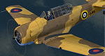
This is a repaint for the payware A2A Simulations AT-6 Texan. This repaint depicts the restored Noorduyn-built Harvard Mk.IIb c/n 14A-1106, owned/operated by John Rayner, based in Australia, and registered as VH-TXN. This aircraft originally served with the RCAF during WWII as FS966, training Commonwealth pilots in the Empire Air Training Scheme in Canada, and from 1946 until 1969 served in the Swedish AF as Sk 16A #16077. Traded from the Swedish AF Museum in 1980 to an Australian collector, the aircraft was later purchased by John Rayner in 1994 and fully restored. The aircraft is painted in the markings of one of the three Harvards supplied to RAF 239 Wing (comprising of RAAF (Australian) 3 & 450 Squadrons and RAF (British) 112 & 250 Squadrons), based in North Africa in 1942, for "Wing Training" - general duties of which included providing check-out flights for new pilots and providing ferrying capability for pilots to pick up replacement aircraft.
| Filename: | RAF_Desert_Air_Force_North_American_AT6_VHTXN.zip |
| License: | Freeware |
| Added: | 21st May 2016, 20:36:08 |
| Downloads: | 342 |
| Author: | John Terrell |
| Size: | 40 MB |
| Category: Flight Simulator X - Aircraft Repaints, Textures and Modifications | |
| Pacific Western Airlines 727-100 |
|
Images related to this file:
File Description:
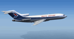
This is a repaint of the 727-100 in Pacific Western Airlines colors. The freeware 727-100 by Tenkuu Developers Studio (TDS) is needed for this repaint. Canadian airline Pacific Western was formed in 1945 under the name Central British Columbia Airways, and they initially only undertook contract work. In 1953 however, they started their first scheduled service and changed their name to Pacific Western Airlines. Over the years they acquired many smaller airlines, and by the 1980s they were Canada's third largest airline. Their route network consisted of domestic Canadian flights. They also operated charters to many countries, and had a vast network of cargo flights, in which they served 90 airports worldwide. In 1987 Pacific Western purchased CP Air, Canada's second largest carrier at the time, and they consequently named the new airline Canadian Airlines International. In 2000 they were taken over and merged into Air Canada. This repaint was tested on P3D v3. It should work on FSX & FSX-SE.
| Filename: | Pacific_Western_Airlines_727100.zip |
| License: | Freeware |
| Added: | 15th June 2018, 13:05:20 |
| Downloads: | 122 |
| Author: | Ted Giana |
| Size: | 9.75 MB |
| Category: Flight Simulator X - AFCAD Files | |
| Ekdahl Airport (NJ59), NJ |
|
File Description:
Located 04 miles S of Freehold, New Jersey, Ekdahl Airport is a private turf strip 1300' in length bordered closely by trees. This makes for an interesting landing as the 90' width of the runway is all the room you have to play with. However because it can be difficult to gauge your distance to trees and also because even the slightest brush with a tree can cause a crash, all trees immediately adjacent to the runway have crash disabled - mainly so you can turn your plane around if you land on Runway 02. The hard surface runway was removed so make sure your terrain mesh complexity is set as high as possible to get that bumpy ground realism. A windsock is listed as being available on this field but I could not locate it in any imagery and so placed it by default near the hangar building. You can start on the runways or parked in front of the hangar. Make sure your plane is capable of these take off and landing distances! Tree height around the field was not listed so I again used my best judgement from studying aerial photos. There is no fuel or parking for transient aircraft available. The field is not lit - daytime VFR operations only are recommended.
Scenery constructed with use of satellite images/streetview/aerial photos - the author has not been there in person.
This scenery is meant to be used in conjunction with MegaScenery Earth New Jersey/Delaware 002. It is not required, but apron use is minimized to allow satellite scenery to show through as much as possible, and objects are placed based on the MSE textures - lack of it may make scenery look out of place.
| Filename: | Ekdahl_Airport_NJ59_NJ.zip |
| License: | Freeware |
| Added: | 13th August 2011, 16:53:55 |
| Downloads: | 172 |
| Author: | Drew Sikora |
| Size: | 550.03 KB |
| Category: Flight Simulator X - AFCAD Files | |
| Peters Airport (4NJ8), NJ v1.1 |
|
File Description:
Located 05 miles W of Somerville, New Jersey on 70 acres of land, Peters Airport is a private turf strip that will test your short field skills to the max. The published runway dimensions for this strip are 1700x200 feet, and for the most case this is fairly accurate - however at the ends of both runways you have tree obstacles to overcome so this can shorten the amount of usable runway significantly, although the tree obstacles are no higher than 12-14m. There is no hardened runway surface so you will be landing/taking off on terrain. Depending on how high your mesh resolution is, this can be a significant factor, as Runway 31 is mainly uphill enough that you will need to power up with parking brakes on if you want to make it in the air. Runway 13 is the best since you are going downhill and the trees at the end are fewer and smaller. Pay close attention to the pattern! Runway 13 is Left and Runway 31 is Right - this airport is within 2 miles of Solberg-Hunterdon (N51) and you don't want to get in the way of that field's traffic! The runway is not lit, so daytime VFR operations only. There are no services at this strip for transient aircraft.
Scenery constructed with use of satellite images/streetview/aerial photos - the author has not been there in person.
This scenery is meant to be used in conjunction with MegaScenery Earth New Jersey/Delaware 001. It is not required, but apron use is minimized to allow satellite scenery to show through as much as possible, and objects are placed based on the MSE textures - lack of it may make scenery look out of place.
| Filename: | Peters_Airport_4NJ8_NJ_v11.zip |
| License: | Freeware |
| Added: | 20th September 2011, 14:08:43 |
| Downloads: | 405 |
| Author: | Drew Sikora |
| Size: | 461.03 KB |
| Category: Flight Simulator X - Scenery | |
| Ireland VFR Small Airports Part 3 |
|
Images related to this file:
File Description:
Ireland VFR Small Airports Part 3. This scenery consists of 1. EIKY Kerry International Airport, 2. EIBN Bantry Airfield, 3. EIBR Birr Airfield, and 4. Clonbullogue Airfield.
Kerry is situated in the South West of Ireland and serves as a gateway to the world famous Lakes of Killarney, The Ring of Kerry and the Dingle Peninsula. Bantry is ideal for visiting the rugged beauty of West Cork. Clonbullogue is home to the Irish Parachute Club and is situated approximately 30 miles southwest of EIDW Dublin. Birr is almost in the centre of Ireland and is home to a very active group of GA aviators.
The scenery has been created almost entirely from real photographs and all objects have been placed accurately using ordinance survey data and satellite imagery. It also includes animated marshallers, aircrew and passengers together with animated animals and vehicles. Appropriate sound effects have been added to each file together with smoke and strobe lighting. Full night lighting is included, with flood and wash lighting of the aprons and carparks. Each airport has been sub-divided into seperate elements, which can be switched on or off according to the users preference and hardware setup. It caters for GA enthuasiasts and for those who prefer to fly the heavies.
This scenery has not been designed as a standalone, it calls on many objects from my Ireland VFR Small Airports parts 1 and 2. It has also been designed to complement photographic scenery but will also work with the default terrain and I have inlcuded a set of landclass and photoreal textures. It also includes an extended set of photoscenery treescapes. Full installation instructions, settings, credits and tips can be found in the README file.
Please enjoy and I hope you like my airports as much as I enjoyed making them.
| Filename: | Ireland_VFR_Small_Airports_Part_3.zip |
| License: | Freeware, limited distribution |
| Added: | 8th April 2012, 22:40:52 |
| Downloads: | 3,759 |
| Author: | George Keogh |
| Size: | 81.33 MB |


© 2001-2026 AVSIM Online
All Rights Reserved
Privacy Policy |