
Where Flight Simulation Enthusiasts Gather from Around the World!
AVSIM Library - Search Results

| Category: Flight Simulator X - AFCAD Files | |
| MDSD - Las Americas - Jose Francisco Pena Gomez Int'l Airport - Santo Domingo, Dominican Republic |

|
Images related to this file:
File Description:
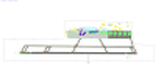
Las Americas International Airport (Spanish: Aeropuerto Internacional Las Americas) (IATA: SDQ, ICAO: MDSD) is an international airport located in Punta Caucedo, near Santo Domingo and Boca Chica in the Dominican Republic. It is the second busiest airport in the country handling over 3 million passengers a year.
Features:
*Taxiways properly designed and signs updated
*Expanded parking apron
*Redesigned terminal building to match most recent renovations
*Accurate gate assignments
*Runway markings and lighting corrected
*Parking spots for commercial traffic
*Separate parking area for GA traffic
*Misc airport buildings added
*Cargo ramp
*Airport vehicles and objects throughout the airport
*Fuel service vehicles
*Static vehicles
*Gas station
*Static vehicles (requires objlib-large-car-parking-fsx.zip)
*Light poles (requires fsx_lts.zip)
| Filename: | MDSD__Las_Americas__Jose_Francisco_Pena_Gomez_Intl.zip |
| License: | Freeware |
| Added: | 8th July 2014, 03:40:55 |
| Downloads: | 1,193 |
| Author: | Jaison Diaz / Endeavour ai |
| Size: | 110.67 KB |
| Category: Flight Simulator X - Scenery | |
| FALE - King Shaka Airport, Durban, South Africa V2 |
|
File Description:
King Shaka International Airport, named after Shaka, leader of the Zulu nation in the early 19th century, also known as La Mercy Airport (after the area in which it is situated) and abbreviated as KSIA, will be the primary airport serving Durban, South Africa. Located at La Mercy, approximately 35 kilometers (22 mi) north of the city centre, it is expected to open on May 1, 2010 (just over a month before the start of the 2010 FIFA World Cup); replacing the existing Durban International Airport. All flights handled by Durban International Airport will terminate on April 30, 2010 and will move to King Shaka International Airport overnight, with KSIA handling its first flight on May 1, 2010.
This updated version caters for AI flight plans and Aircraft.
| Filename: | FALE__King_Shaka_Airport_Durban_South_Africa_V2.zip |
| License: | Freeware |
| Added: | 8th April 2010, 00:07:56 |
| Downloads: | 2,149 |
| Author: | Pierre Cornelissen & Mundus Yssel |
| Size: | 22.17 KB |
| Category: Flight Simulator X - Scenery | |
| FALE King Shaka Airport |
|
File Description:
King Shaka International Airport, named after Shaka, leader of the Zulu nation in the early 19th century, also known as La Mercy Airport (after the area in which it is situated) and abbreviated as KSIA, will be the primary airport serving Durban, South Africa. Located at La Mercy, approximately 35 kilometers (22 mi) north of the city centre, it is expected to open on May 1, 2010 (just over a month before the start of the 2010 FIFA World Cup); replacing the existing Durban International Airport. All flights handled by Durban International Airport will terminate on April 30, 2010 and will move to King Shaka International Airport overnight, with KSIA handling its first flight on May 1, 2010. This updated version caters for AI flight plans and Aircraft. I just added jetways
| Filename: | FALE_King_Shaka_Airport.zip |
| License: | Freeware |
| Added: | 2nd May 2010, 05:36:47 |
| Downloads: | 5,658 |
| Author: | Pierre Cornelissen & Mundus Yssel: Peter Vermeulen added jet ways |
| Size: | 28.58 KB |
| Category: Flight Simulator X - Scenery | |
| HALA - Hawassa Intl. - Hawassa, Ethiopia |
|
Images related to this file:
File Description:
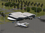
This project adds the booming city of Hawassa, Ethiopia, creates the new international airport (HALA), moves (and rebuilds) the downtown airport (recoded to HALX), and includes AI flight plans for the Ethiopian Airlines service that began April 2016. Tested in both the default FSX: Acceleration and with FTX Global/Vector, accurate coastlines, lakes, road data, and SRTMGL1 (30m) mesh, as well as corrected landclass are provided based on the latest available satellite imagery. The Hawassa International Airport was created using information from the current satellite footprint and the promotional video from Ethiopian Airports Enterprise (EAE). Although there is still very little published data on the airport, it is fully functional.
Updates were created or rebuilt in a manner which carefully aligns airport data with current satellite imagery. Scenery was created using Airport Design Editor X v1.70.6042, SBuilderX 3.13, and the FSX Object Placement Tool. Scenery objects were added and modified from stock FSX scenery to resemble as closely as possible the actual airports. The FSX apron lights included are from the set created by Jim Dhaenens. Thanks to Ron Blehm for bringing this part of the world to my attention.
| Filename: | HALA__Hawassa_Intl___Hawassa_Ethiopia.zip |
| License: | Freeware |
| Added: | 20th July 2016, 09:06:40 |
| Downloads: | 1,022 |
| Author: | Carlyle Sharpe |
| Size: | 10.41 MB |
| Category: Flight Simulator X - Scenery | |
| Bhutan Airports and Paro Valley |
|
Images related to this file:
File Description:
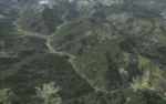
This project adds and updates all of the airports of Bhutan. Bathpalathang (VQBT) and Gelephu (VQGP) are added, Yongphulla (VQ10) is updated and recoded as VQTY, and Paro (VQPR) is fully updated to reflect current satellite imagery. These are all fully functioning AI airports as well. Special attention was given to the entire Paro Valley, and numerous road/river vectors were updated around Gelephu. Accurate coastlines, lakes, road and river data, as well as corrected landclass are provided based on the latest available satellite imagery. They are optimized to fit seamlessly with FTX Vector's roads/water, but they should be fully functional in all FSX configurations.
GA-encoded flight plans for the Buddha Air/Kathmandu charter are provided to enhance service to Paro. NASA SRTM Global 3 arc second terrain mesh is also included for all of Bhutan. Updates were created or rebuilt in a manner which carefully aligned airport data with current satellite imagery, when available. Scenery was created using Airport Design Editor X v1.61.5298, SBuilderX 3.13, and the FSX Object Placement Tool. Scenery objects were added and modified from stock FSX scenery to resemble as closely as possible the actual airports.
| Filename: | Bhutan_Airports_and_Paro_Valley.zip |
| License: | Freeware |
| Added: | 19th January 2015, 06:09:17 |
| Downloads: | 11,440 |
| Author: | Carlyle Sharpe |
| Size: | 21.4 MB |
| Category: Flight Simulator X - Scenery | |
| Whale Island (Hi Resolution Photo and mesh), New Zealand |
|
Images related to this file:
File Description:
Whale Island (Maori Name: Moutohora) is a small island located off the Bay of Plenty coast of New Zealand's North Island. It is located about 12 kilometers north of the town of Whakatane. A whaling station existed on the island during the 19th century. The 1.43 km island is a remnant of a complex volcano which has eroded, leaving two peaks. This is still an area of volcanic activity and there are hot springs on the island in Sulphur Valley, McEwans Bay, and Sulphur Bay.
This Hi Resolution scenery was created from a 0.25m pixel resolution Ortho-rectified Aerial mosaic owned by Environment Bay of Plenty (The Bay of Plenty Regional Council) and flown in 2007. The imagery has been slightly de-sampled for use in Flight Simulator X and utilizes the a custom hi resolution 5m Mesh derived from photogrammetry data off the photos. The textures are intended for summer daylight flying only, although due to the evergreen nature of New Zealand's native bush, the Islands appearance remains relatively constant throughout the year.
The island contains a small helicopter pad which is used for checking the various radio antennas on the Island. There is also a small Department of Conservation hut near the south western tip of the Island. These objects have been added from the FSX library of objects. Make sure to turn up your graphics sliders to make the most of this data! To find the Island fly north from Whakatane airport.
| Filename: | Whale_Island_Hi_Resolution_Photo_and_mesh_New_Zeal.zip |
| License: | Freeware, limited distribution |
| Added: | 20th January 2010, 10:12:14 |
| Downloads: | 4,650 |
| Author: | Tim Barnes |
| Size: | 9.94 MB |
| Category: Flight Simulator X - Aircraft Repaints, Textures and Modifications | |
| Supermarine Spitfire R7143 |
|
Images related to this file:
File Description:
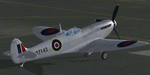
Repaint for the A2A Wings of Power III Spitfire by Jan Kees Blom, based on the paintkit by Martin Catney: Supermarine Spitfire R7143 was built as a Mk.1 in 1941 as presentation aircraft 'Wallsall I', and was converted to a MK.PR IV, and flew with 140 squadron. She was involved in a landing accident in early 1942, but was repaired and shipped to Canada in january 1943. Here she served with 13 squadron in Rockcliffe, Ontario, before being damaged again in a landing accident in september 1944. Repairs kept her on the ground until june 1945. She was displayed in a silver scheme after the war during the Air Show in Toronto, 1946, and later flew Air Search Rescue missions. Her last flight was in october 1947, after which she became an instuctional airframe at the RCN air electrical school. She was scrapped here in 1950.
| Filename: | Supermarine_Spitfire_R7143.zip |
| License: | Freeware |
| Added: | 9th February 2011, 16:10:08 |
| Downloads: | 271 |
| Author: | Jan Kees Blom |
| Size: | 10.07 MB |
| Category: Flight Simulator X - Aircraft Repaints, Textures and Modifications | |
| Fokker 100 Repaint Mega Pack Part One |
|
Images related to this file:
File Description:
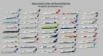
This is a repaint pack for the Digital Aviation Fokker 100. I have included 44 repaints of airlines from all over the world. There are some fictional and some real repaints included, so you can fly with this aircraft everywhere! The following airlines are included: China Eastern, Skyways, Merpati Nusantara, Carpatair, Belleair, Air France by Regional, Dutch Antilles Express, Korean Air, Montenegro Airlines, Skywest, Spanair, South African Airways, ANA, Tunisair, Nigerian Eagle, Aerolineas Argentinas, Royal Jordanian, Fly Be, United, S7, TAME, PIA Pakistan International, Precision Air, Thai International Airlines, Alaska Air, Olympic Air, Delta, Air Baltic, TAM, Kenya Airways, Iberia, Lan, British Airways, Air Canada, Alitalia, Philippine Airlines, SAS, Lufthansa, Air Caraibes, Continental, UTair, Air China, Dragonair and Turkish Airlines!
IMPORTANT: This is part one of the repaint pack, you will need part two, in order to have all repaints: DA_Fokker100_repaintmegapack_part_TWO.zip
By Sebastian Szucs
| Filename: | Fokker_100_Repaint_Mega_Pack_Part_One.zip |
| License: | Freeware, limited distribution |
| Added: | 11th May 2010, 21:31:44 |
| Downloads: | 7,163 |
| Author: | Sebastian Szucs |
| Size: | 84.6 MB |
| Category: Flight Simulator X - Aircraft Repaints, Textures and Modifications | |
| Fokker 100 Repaint Mega Pack Part Two |
|
Images related to this file:
File Description:
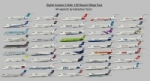
This is a repaint pack for the Digital Aviation Fokker 100. I have included 44 repaints of airlines from all over the world. There are some fictional and some real repaints included, so you can fly with this aircraft everywhere! The following airlines are included: China Eastern, Skyways, Merpati Nusantara, Carpatair, Belleair, Air France by Regional, Dutch Antilles Express, Korean Air, Montenegro Airlines, Skywest, Spanair, South African Airways, ANA, Tunisair, Nigerian Eagle, Aerolineas Argentinas, Royal Jordanian, Fly Be, United, S7, TAME, PIA Pakistan International, Precision Air, Thai International Airlines, Alaska Air, Olympic Air, Delta, Air Baltic, TAM, Kenya Airways, Iberia, Lan, British Airways, Air Canada, Alitalia, Philippine Airlines, SAS, Lufthansa, Air Caraibes, Continental, UTair, Air China, Dragonair and Turkish Airlines!
IMPORTANT: This is part two of the repaint pack, you will need part one, in order to have all repaints: DA_Fokker100_repaintmegapack_part_ONE.zip
By Sebastian Szucs
| Filename: | Fokker_100_Repaint_Mega_Pack_Part_Two.zip |
| License: | Freeware, limited distribution |
| Added: | 11th May 2010, 23:12:36 |
| Downloads: | 6,588 |
| Author: | Sebastian Szucs |
| Size: | 89.97 MB |
| Category: Flight Simulator X - AFCAD Files | |
| P13 - San Carlos Apache Airport, Globe, Arizona. |
|
File Description:
This is a redesign of P13 - San Carlos Apache Airport, Globe, Arizona. Google Maps and Skyvectors have been used to provide the correct (as physically possible within FSX and ADE) position, size and type of runway, aprons and buildings. The immediate surrounding scenery has been included. ADE used to compile the design.
| Filename: | P13__San_Carlos_Apache_Airport_Globe_Arizona.zip |
| License: | Freeware |
| Added: | 11th December 2017, 20:28:01 |
| Downloads: | 170 |
| Author: | Matthew Ward |
| Size: | 146.09 KB |


© 2001-2026 AVSIM Online
All Rights Reserved
Privacy Policy |