
Where Flight Simulation Enthusiasts Gather from Around the World!
AVSIM Library - Search Results

| Category: Flight Simulator X - AFCAD Files | |
| SGAS - Silvio Pettirossi International Airport - Asuncion, Paraguay |

|
Images related to this file:
File Description:
Silvio Pettirossi International Airport (IATA: ASU, ICAO: SGAS) is Paraguay's main national and international gateway, located at Luque, suburb of the capital Asuncion. It is named after the Paraguayan aviator Silvio Pettirossi. The airport serves as a hub for TAM Airlines Paraguay and also receives international service from several carriers.
Features:
*Taxiways properly designed and signs updated
*Expanded parking apron
*Redesigned terminal building
*Runway markings and lighting corrected
*Parking spots for commercial traffic
*Parking area for GA traffic
*Parking for military aircraft
*Misc airport buildings added
*Airport vehicles and objects throughout the airport
*Fuel service vehicles
*Fire station
*Static vehicles (requires objlib-large-car-parking-fsx.zip)
*Light poles (requires fsx_lts.zip)
| Filename: | SGAS__Silvio_Pettirossi_International_Airport__Asu.zip |
| License: | Freeware |
| Added: | 8th July 2014, 23:14:09 |
| Downloads: | 1,071 |
| Author: | Jaison Diaz / Endeavour ai |
| Size: | 105.75 KB |
| Category: Flight Simulator X - AFCAD Files | |
| Windward Farms Airport (4NJ0), NJ |
|
File Description:
Located 02 miles NW of Rosemont, New Jersey, Windward Farms Airport is a private turf strip. Like most small private turf strips this one can prove to be slightly challenging when it comes to taking off and landing - especially in a crosswind. The runway threads between two separate stands of trees to either side, and 1/4 of the Runway 11 left side is hedged by small trees and bushes. While the published dimensions for this strip are 3500x150 feet, in reality the usable runway space is really 3000x100 feet due to vegetation. This airport as rendered in FSX does not have an actual runway surface, so when you land you will be landing on actual terrain. There isn't a noticeable slope but it can be bumpy so use caution! Edge lighting is provided for the runway, although night landings/takeoffs are not recommended. There are no services provided by this airfield. After landing why not taxi over to the hangar and feed the sheep grazing in the pasture?
Scenery constructed with use of satellite images/streetview/aerial photos - the author has not been there in person.
This scenery is meant to be used in conjunction with MegaScenery Earth New York 007. It is not required, but apron use is minimized to allow satellite scenery to show through as much as possible, and objects are placed based on the MSE textures - lack of it may make scenery look out of place.
| Filename: | Windward_Farms_Airport_4NJ0_NJ.zip |
| License: | Freeware |
| Added: | 1st February 2011, 10:29:23 |
| Downloads: | 201 |
| Author: | Drew Sikora |
| Size: | 563.16 KB |
| Category: Flight Simulator X - AFCAD Files | |
| Stallone Airport (9NJ5), NJ |
|
File Description:
Located 01 miles SE of Harrisonville, New Jersey, Stallone Airport is a private turf strip 1350' in length. However it should be noted that the actual length from the road to the trees on the opposite end of the runway is actually only around 900'. It is tightly hemmed in by trees so if you are landing on Runway 29 you may want to use Slew to turn your plane around to remove the risk of bumping into a tree instead. If you land on Runway 11 you can cross the road to turn around in the field opposite the runway. The windsock can be seen from both runways. Power lines run along the heights of the trees as well for the Runway 29 approach, on the same side as the trees though so not really any additional worry there. No transient services are available. There is no hard surface runway so make sure your terrain mesh slider is set as high as possible for a suitably bumpy ground experience.
Scenery constructed with use of satellite images/streetview/aerial photos - the author has not been there in person.
This scenery is meant to be used in conjunction with MegaScenery Earth New Jersey/Delaware 004. It is not required, but apron use is minimized to allow satellite scenery to show through as much as possible, and objects are placed based on the MSE textures - lack of it may make scenery look out of place.
| Filename: | Stallone_Airport_9NJ5_NJ.zip |
| License: | Freeware |
| Added: | 5th April 2011, 07:34:54 |
| Downloads: | 170 |
| Author: | Drew Sikora |
| Size: | 332.91 KB |
| Category: Flight Simulator X - Scenery | |
| North Central Ecuador v3, including SEQM (SEQU) and SEIB |
|
Images related to this file:
File Description:
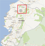
FSX/P3D Version 3 of this scenery is a completely new build of SEQM from the ground up. The entire complex is rendered using FSX objects along with the new highway that connects to the highway infrastructure with AI road traffic. The airport is now at a mean altitude that better blends with the newly included NASA SRTM GL1 30m mesh for the region. The tower is at the correct altitude. Buildings use more accurate footprints, new models, floating jetways, and updated landclass, and work seamlessly with the roads added by FTX Global/Vector. Lakes are corrected within roughly 100 square miles. Although the Ibarra/Atahualpa (SEIB) airport no longer exists, there is an option to add it back. Startup files are included to fly from the lakes and the Ibarra/Atahualpa (SEIB) airport. As a “bonusâ€, SEQU was restored in this version, because much of the footprint of the airport still remains as part of its conversion to a park. As such, a custom and fully functional SEQU is included for users who would like to revisit the old airport. AI Traffic can be restored at SEQU by simply using the "Reversed SEQU-SEQM AI Traffic" option. Scenery was created using Airport Design Editor X v1.76.6715, SBuilderX 3.13, and the FSX Object Placement Tool. Scenery objects were added and modified from stock FSX scenery to resemble as closely as possible the actual airport. Bill Leaming's Ramp Lights for P3D/FSX illuminate the aprons.
| Filename: | North_Central_Ecuador_v3_including_SEQM_SEQU_and_S.zip |
| License: | Freeware |
| Added: | 22nd March 2020, 22:13:37 |
| Downloads: | 4,124 |
| Author: | Carlyle Sharpe |
| Size: | 29.44 MB |
| Category: Flight Simulator X - Missions | |
| AlsaceTour3.zip |
|
File Description:
Intermediate helicopter mission. Take passengers on an aerial tour of the Alsace Region of France. This is tour 3 of 4. Requires an addtional download of the Alsace scenery if you did not get it for tour 1 or 2. Instructions included in the zip file.
| Filename: | AlsaceTour3zip.zip |
| License: | Freeware |
| Added: | 2nd October 2020, 18:26:41 |
| Downloads: | 101 |
| Author: | helomissionman |
| Size: | 15.7 MB |
| Category: Flight Simulator X - Missions | |
| IhuruShuttle.zip |
|
File Description:
Beginner helicopter mission. Shuttle tourists from Male International airport to the resort island of Ihuru. This mission requires that you have at least the Orbx global base pack installed on your system. Ihuru island only exists in the Orbx scenery. See details in the zip file.
| Filename: | IhuruShuttlezip.zip |
| License: | Freeware |
| Added: | 19th December 2020, 20:16:34 |
| Downloads: | 48 |
| Author: | HeloMissionMan |
| Size: | 5.32 MB |
| Category: Flight Simulator X - Missions | |
| PompeiiHelicopterTour.zip |
|
File Description:
Intermediate/Advanced Helicopter mission. Take passengers on an aerial tour of Mount Vesuvius and the ruins of Pompeii. Requires an additional download of the scenery files for Pompeii. Instructions included in the zip file. Will require lots of hovering over the ruins as you view the site.
| Filename: | PompeiiHelicopterTourzip.zip |
| License: | Freeware |
| Added: | 25th January 2020, 16:29:16 |
| Downloads: | 90 |
| Author: | HeloMissionMan |
| Size: | 4.65 MB |
| Category: Flight Simulator X - Missions | |
| StMarysHeliSupport.zip |
|
File Description:
Intermediate helicopter mission. A helicopter located at (EGHE) airport provides support services. Fly different sorties as needed by the residents of the Isles of Scilly, UK. This mission requires that you have Orbx EU-FTX-England scenery installed on your system. It will not work without it.
| Filename: | StMarysHeliSupportzip.zip |
| License: | Freeware |
| Added: | 8th April 2022, 15:30:09 |
| Downloads: | 33 |
| Author: | helomissionman |
| Size: | 4.05 MB |
| Category: Flight Simulator X - Aircraft Repaints, Textures and Modifications | |
| Grumman F6F Hellcat VF-40 Package |
|
Images related to this file:
File Description:
This package contains 7 repaints for the Real Flight (Vertigo Studios) F6F Hellcat, they represent aircraft Nos 1 through 7 of VF40, stationed at Barakoma, to complement the Barakoma Scenery by Jim Dhaenens http://www.simviation.com/simviation/download.php?ID=8027 and http://www.simviation.com/simviation/download.php?ID=8135
| Filename: | Grumman_F6F_Hellcat_VF40_Package.zip |
| License: | Freeware, limited distribution |
| Added: | 16th June 2010, 22:13:31 |
| Downloads: | 212 |
| Author: | Bruce Martin / Real Flight (Vertigo Studios) |
| Size: | 11 MB |
| Category: Flight Simulator X - Scenery | |
| Titusville, FL - Spacecoast Regional Airport (KTIX) |
|
Images related to this file:
File Description:
Generic floating buildings have been replaced with custom and library objects. Landclass changes, roads, rework of runways, taxiways and aprons, placement of library objects and a library of new airport buildings are included. Scenery in this package is based on Virtual Earth (Bing) and Google Earth imagery.
| Filename: | Titusville_FL__Spacecoast_Regional_Airport_KTIX.zip |
| License: | Freeware |
| Added: | 12th November 2010, 23:29:57 |
| Downloads: | 1,473 |
| Author: | Art Poole |
| Size: | 1.16 MB |


© 2001-2026 AVSIM Online
All Rights Reserved
Privacy Policy |