
Where Flight Simulation Enthusiasts Gather from Around the World!
AVSIM Library - Search Results

| Category: Flight Simulator X - Aircraft Repaints, Textures and Modifications | |
| South Pacific Airways, Douglas C-47 (E5-SBN) Metalic Scheme |

|
Images related to this file:
File Description:
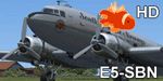
Repaint of Manfred Jahn's C-47 in the colors of South Pacific Airways, a FSEconomy group with the operations focused in the paradisiac South Pacific islands area. Requires Manfred Jahn's C-47 Skytrain Exterior Base Pack 1.0
| Filename: | South_Pacific_Airways_Douglas_C47_E5SBN_Metalic_Sc.zip |
| License: | Freeware |
| Added: | 4th February 2012, 19:39:58 |
| Downloads: | 128 |
| Author: | Jose Eduardo |
| Size: | 12.63 MB |
| Category: Flight Simulator X - Aircraft Repaints, Textures and Modifications | |
| South Pacific Airways Douglas C-47 (E5-SBN) Vintage Scheme |
|
Images related to this file:
File Description:
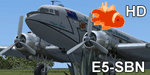
Repaint of Manfred Jahn's C-47 in the colors of South Pacific Airways, a FSEconomy group with the operations focused in the paradisiac South Pacific islands area. Requires Manfred Jahn's C-47 Skytrain Exterior Base Pack 1.0
| Filename: | South_Pacific_Airways_Douglas_C47_E5SBN_Vintage_Sc.zip |
| License: | Freeware |
| Added: | 7th March 2012, 01:55:03 |
| Downloads: | 161 |
| Author: | Jose Eduardo |
| Size: | 11.93 MB |
| Category: Flight Simulator X - Scenery | |
| YABS Albion Downs Sheep Station, Western Australia |
|
File Description:
YABS Albion Downs is a remote Sheep Station in the Shire of Wiluna and includes the dirt strip and homstead complex. Landing Area BGL files by Alan Blencowe - REQUIRES MODEL LIBRARY & TEXTURE KIT from Avsim or www.alanblencowe.com
| Filename: | YABS_Albion_Downs_Sheep_Station_Western_Australia.zip |
| License: | Freeware |
| Added: | 25th February 2013, 02:51:35 |
| Downloads: | 568 |
| Author: | Alan Blencowe |
| Size: | 4.85 MB |
| Category: Flight Simulator X - Missions | |
| SpecOpsTraining.zip |
|
File Description:
Expert helicopter mission. A military helicopter located at X51 is providing jump training for special ops jumpers. Take the jumper out to a special area in the Everglades for training. This mission is very difficult but doable.
| Filename: | SpecOpsTrainingzip.zip |
| License: | Freeware |
| Added: | 15th October 2021, 15:17:06 |
| Downloads: | 88 |
| Author: | helomissionman |
| Size: | 8.99 MB |
| Category: Flight Simulator X - Scenery | |
| LIPX, Verona 'Villafranca' Airport Italy |
|
Images related to this file:
File Description:
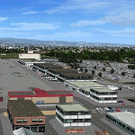
New setup to a decent freeware alternative. Villafranca is located 10 km (6.2 miles) southwest of Verona, Italy and services commercial flights. During the Bosnian War, the airbase was used by NATO aircraft as a staging area.
| Filename: | LIPX_Verona_Villafranca_Airport_Italy.zip |
| License: | Freeware |
| Added: | 4th May 2018, 05:07:51 |
| Downloads: | 3,075 |
| Author: | Tim van Ringen |
| Size: | 3.78 MB |
| Category: Flight Simulator X - Scenery | |
| Remote Tower Base, Washington State USA |
|
File Description:
Remote Tower Base Operations, Washington State - Airport ID: TOWR (FSX). -
OK, all you Rotorheads - This is a fictional version of a very remote Helicopter landing pad on the Olympic Penn.. You must fly a Helo. I created it for my personal enjoyment and now I am releasing to the public as freeware. I hope you enjoy the "eye-candy". There are multiple radio and fire spotting towers in the area to check out. -
At least it gives you something to travel there for. -
This is an extremely challenging spot to land, especially using real Wx. The landing pad is basically a postage stamp. I created it and have a tough time landing here myself, so have fun with this one. -
You may also go directly to this airport by selecting TOWR as your starting airport. I also added a series of images so you can figure out how to get there from somewhere else. If you have my Wynoochie Lake scenery, its only 6 miles from there. (Just a heads-up) -
Designed with the FS X Sdk Scenery function of the Mission builder, Lee Swordy's AFCAD & the Abacus Scenery shortcut tool. -
This scenery is frame rate friendly.
| Filename: | Remote_Tower_Base_Washington_State_USA.zip |
| License: | Freeware |
| Added: | 3rd May 2007, 21:13:18 |
| Downloads: | 758 |
| Author: | Bob Caparoula |
| Size: | 5.85 MB |
| Category: Flight Simulator X - AFCAD Files | |
| Flying W Airport (N14), NJ |
|
File Description:
Located 01 miles SW of Lumberton, New Jersey on 170 acres of land, Flying W Airport services small to medium GA aircraft as well as helicopters. Transient storage are tie downs only. There are plenty of places to park. The main parking area in on the west side of the airport on the south end of the north tarmac and can handle wingspans of up to 50 feet. You can also park slightly north among the static aircraft or east of the runway on the grass. Collisions are disabled with static craft in these areas to assist with parking. Both 100LL and Jet-A are available by stopping at the south tarmac next to the fuel tank or the north tarmac by the fuel trucks in front of the terminal. Trees are summertime ONLY.
Scenery constructed with use of satellite images/streetview, the author has not been there in person.
This scenery is meant to be used in conjunction with MegaScenery Earth New Jersey/Delaware 002. It is not required, but apron use is minimized to allow satellite scenery to show through as much as possible, and objects are placed based on the MSE textures - lack of it may make scenery look out of place.
| Filename: | Flying_W_Airport_N14_NJ.zip |
| License: | Freeware |
| Added: | 24th October 2010, 18:53:47 |
| Downloads: | 217 |
| Author: | Drew Sikora |
| Size: | 805.7 KB |
| Category: Flight Simulator X - AFCAD Files | |
| Bridgeport-Cahill Field Airport (6NJ9), NJ |
|
File Description:
Located 01 miles SW of Bridgeport, New Jersey on 167 acres of land, this airport is non-existent in real life, as far as I am able to determine. although it is still listed as Active, no visible trace of anything remotely suitable for a landing strip is visible anywhere in this area. The strip mining operation nearby in some satellite/aerial photos shows a long narrow grass strip that could be used as a runway, but then others show it stripped down to bare dirt as part of the apparent mining operation, and the MegaSceneryEarth textures depict this latter representation as well. So I have simply removed visible evidence of this strip, although FSX will still try to tell you it's there in the airport directory.
Scenery constructed with use of satellite images/streetview/aerial photos - the author has not been there in person.
This scenery is meant to be used in conjunction with MegaScenery Earth New Jersey/Delaware 004. It is not required, but apron use is minimized to allow satellite scenery to show through as much as possible, and objects are placed based on the MSE textures - lack of it may make scenery look out of place.
| Filename: | BridgeportCahill_Field_Airport_6NJ9_NJ.zip |
| License: | Freeware |
| Added: | 10th February 2011, 05:01:38 |
| Downloads: | 197 |
| Author: | Drew Sikora |
| Size: | 209.8 KB |
| Category: Flight Simulator X - AFCAD Files | |
| Halka Nurseries Airport (9NJ6), NJ |
|
File Description:
Located 02 miles W of Fairton, New Jersey on 150 acres of land, Halka Nurseries Airport is a private turf strip 2400' in length. The airspace has been analyzed and deemed suitable for aircraft up to a light twin. Take caution on the Runway 18 approach as power lines are strung up along the street opposite the runway. There is no hard surfaced runway so have your terrain mesh set as high as possible to experience bumpy terrain. There is no windsock, so be sure to know your weather before arriving or departing - the winds in this area are predominantly out of the west and this runway is north/south. Trees and bushes are close to some areas of the runway and can pose a danger in high crosswinds. There are no services for transient aircraft.
Scenery constructed with use of satellite images/streetview/aerial photos - the author has not been there in person.
This scenery is meant to be used in conjunction with MegaScenery Earth New Jersey/Delaware 005. It is not required, but apron use is minimized to allow satellite scenery to show through as much as possible, and objects are placed based on the MSE textures - lack of it may make scenery look out of place.
| Filename: | Halka_Nurseries_Airport_9NJ6_NJ.zip |
| License: | Freeware |
| Added: | 6th April 2011, 03:27:56 |
| Downloads: | 207 |
| Author: | Drew Sikora |
| Size: | 829.12 KB |
| Category: Flight Simulator X - AFCAD Files | |
| Red Lion Airport (N73), NJ |
|
File Description:
Located 02 miles S of Vincentown, New Jersey on 92 acres of land, Red Lion is a public airfield with a single asphalt runway 2880' in length. Tie downs are available at the Runway 23 end of the airport with South parking being the main tie down area. North parking is on the grass off the main taxiways and East parking is behind the main hangar near the parking lot. All parking is for aircraft with wingspans of 40' or less. Fuel is available by stopping near the tank next to the main hangar near Runway 23. PAPI for Runway 23 is out of service indefinitely, which is why you will see the PAPI boxes but no lights. All static objects and trees adjacent to the taxiways and parking spots have collision disabled.
Scenery constructed with use of satellite images/streetview/aerial photos - the author has not been there in person.
This scenery is meant to be used in conjunction with MegaScenery Earth New Jersey/Delaware 002. It is not required, but apron use is minimized to allow satellite scenery to show through as much as possible, and objects are placed based on the MSE textures - lack of it may make scenery look out of place.
| Filename: | Red_Lion_Airport_N73_NJ.zip |
| License: | Freeware |
| Added: | 9th December 2011, 14:20:51 |
| Downloads: | 171 |
| Author: | Drew Sikora |
| Size: | 1.06 MB |
© 2001-2026 AVSIM Online
All Rights Reserved
Privacy Policy |