
Where Flight Simulation Enthusiasts Gather from Around the World!
AVSIM Library - Search Results

| Category: Flight Simulator X - Scenery | |
| British Columbia and Washington seaplane bases |

|
File Description:
Scenery for four seaplane bases in British Columbia Canada (Vancouver, Victoria, Nanaimo) and one in the state of Washington USA (Rosario, Orcas Island). Only default FsX objects used. Many landclasses fixed, roads added in Orcas Island, shore lines of Nanaimo fixed and a missing island added.
| Filename: | British_Columbia_and_Washington_seaplane_bases.zip |
| License: | Freeware, limited distribution |
| Added: | 4th March 2007, 21:30:05 |
| Downloads: | 7,918 |
| Author: | Ville Elomaa |
| Size: | 957.45 KB |
| Category: Flight Simulator X - Scenery | |
| CYYJ (2017) for FS9, FSX and P3D |
|
Images related to this file:
File Description:

CYYJ (2017), Version 7, is a major upgrade to CYYJ (2014). It portrays the Victoria (British Columbia, Canada) International Airport (CYYJ), aviation museum, Pat Bay floatplane base (CAP5) and Coast Guard station, and nearby industrial park as they appeared in early 2017 - as well as a host of static aircraft. It is fully compatible with Victoria+ (both FS2004 And FSX versions), Ultimate Terrain Canada/Alaska for FS2004 and Ultimate Terrain X - Canada for FSX, ORBX's FTX NA Blue and other FS9 road and shoreline upgrades for the area. CYYJ (2017) includes aircraft and traffic files for a realistic AI scenario other than scheduled airline operations. (Use BC Regional AI - also available from this file library - for scheduled traffic).
Version 7 adds all the recent major new construction and apron expansion at CYYJ, and includes a greater level of detail in many areas.
| Filename: | CYYJ_2017__for_FS9_FSX_and_P3D.zip |
| License: | Freeware, limited distribution |
| Added: | 24th May 2017, 18:30:48 |
| Downloads: | 5,984 |
| Author: | Don Grovestine |
| Size: | 118.7 MB |
| Category: Flight Simulator X - Scenery | |
| Kjeller Area Scenery X |
|
File Description:
This is a scenery around Kjeller airport with photo realistic ground for MS Flight Simulator X.
This scenery needs KjellerX by Ulf H. Aass installed to work properly. Or you will see the runway from the photoscenery outside RW from flightsim.
You can download KjellerX from here (needs winrar):
http://www.home.no/resonut/kjeller.rar
| Filename: | Kjeller_Area_Scenery_X.zip |
| License: | Freeware |
| Added: | 29th April 2009, 01:45:33 |
| Downloads: | 384 |
| Author: | Bjørn Johnny Jensen |
| Size: | 36.03 MB |
| Category: Flight Simulator X - Helicopters | |
| Virtavia Seaking VIH Shortsky |
|
Images related to this file:
File Description:
This is a repaint of Vancouver Island Helicopters Shortsky based on the real aircraft C-FQNG, as closely as the Virtavia SEAKING model (required) permits. vancouver Island helicopters is based in Victoria, BC CANADA.
| Filename: | Virtavia_Seaking__VIH_Shortsky.zip |
| License: | Freeware |
| Added: | 15th February 2023, 00:24:08 |
| Downloads: | 59 |
| Author: | Bruce G Miller |
| Size: | 5.65 MB |
| Category: Flight Simulator X - Scenery | |
| Scenery Oksboel shooting area EKOL |
|
File Description:
I was getting tired of in FSX not having any scenery to practice weapon delivery (fx.TacPack from VRS) here in Denmark, so I decided, to try to make the Oksboel (Oksbøl) shooting area, which are used by the Danish military (air force too) for weapons training.
I made it photo real and with autogen vegetation (autogen annotator) and it contents some homemade targets: 10, 7, 5m shooting targets, SAM missile launchers, SAM radar and tank made of Bob Lacy.
I have tryed the scenery into P3D (version 3) and it worked fine there. (autogen vegetation too)
| Filename: | Scenery_Oksboel_shooting_area_EKOL.zip |
| License: | Freeware |
| Added: | 17th December 2017, 20:19:12 |
| Downloads: | 323 |
| Author: | Otto Knudsen |
| Size: | 41.87 MB |
| Category: Flight Simulator X - AFCAD Files | |
| Active ILS - Victoria Intl BC Canada 'CYYJ' |
|
File Description:
This bgl file fixes the ILS Localizer and Glideslope Transmitters for CYYJ. FSX inadvertently misplaced the Localizer to the rightside of the runway. CYYJ is not a offset ILS type Approach. No other changes have been made to the airport.
| Filename: | Active_ILS__Victoria_Intl_BC_Canada_CYYJ.zip |
| License: | Freeware, limited distribution |
| Added: | 8th January 2007, 12:34:55 |
| Downloads: | 2,377 |
| Author: | Jim Vile |
| Size: | 2.53 KB |
| Category: Flight Simulator X - Scenery | |
| Victoria, Canada including US Southern Gulf Islands and San Juan Islands - Part 1 of 2 |
|
Images related to this file:
File Description:
FSX-only version of Victoria, Canada area scenery including the Southern Gulf Islands and the San Juan Islands of the US. Includes automated installer and configurator by Scot Fraser.
Features:
-accurate shorelines, lakes and streams;
-landclass;
-FSX multi-LOD mesh with 10m maximum resolution;
-complete road network with moving traffic;
-railroads;
-utility corridors;
-marinas and ferry terminals;
-many static boats, including a custom model of the Canada Coast Guard ship Sir Wilfred Laurier;
-detailed models of major buildings and the Ogden Point Terminal;
-many bridges;
-nearly 300 marine lights; and corrected antennae locations.
Facilities include Don Grovestine's famous CYYJ (Victoria International Airport); 12 other Canadian land-based airports: Butler Field, Duncan (CAM3), Gaines, Hastings, Hudson Island, James Island, Thomas, Village Bay, Raven Field (CML2), Saltspring, Sidney Island, Whiskey Point; 20 US airports Blakely (38WA), Burden (61WA), Center Island (79WA), Clam Harbor (WA35), Crane Island, Decatur Shores (WN07), Decatur-Jones (WA18), Waldronaire (90WA), Orcas Island (KORS), Friday Harbour (KFHR), Lopez Island (S31), Pile Point, Roche Harbor (WA09), Shaw Island, Stuart Island Airpark (7WA5), Stuart Island West (2WA3), Wilding (6WA5), Windsock (4WA4); 12 floatplane facilities: Bedwell (CAB3), Fisherman's Bay (WA81), Friday Harbor (W33), Ganges (CAX6), Maple Bay, Mayne (CAW7), Port Washington (CAP8), Roche Harbor (W39), Rosario (W49), Shawnigan Lake (CAV8), Victoria Harbour (CYWH), Victoria International (CAP5) and Westsound, Orcas (WA83) - many with AI traffic; 9 heliports: Ganges (CAL7), Mayne (CBF5), Camel Point (CBF7), Jubilee (CBK8), Victoria General (CBW7) Madrona Bay (CBW9), Shoal Point (CBZ7), Mount Belcher (CMBH).
AI models include the DHC-2 floatplane in local liveries, a cruise ship model (by Mitsuya Hamaguchi) and two repaints, pilot boat, and small boats (by Larry Silsbee).
Ultimate Terrain X compatible (not required). Users of Vancouver+ for FSX will also get additional cruise ship traffic and additional floatplane and helicopter traffic. Full documentation. By Don Grovestine, Jon Patch and Holger Sandmann. Many other contributors: see documentation. Part 1 of 2 - you also need file vicenh7b.zip
| Filename: | Victoria_Canada_including_US_Southern_Gulf_Islands.zip |
| License: | Check within download |
| Added: | 29th January 2010, 21:23:17 |
| Downloads: | 23,160 |
| Author: | Don Grovestine, Jon Patch and Holger Sandmann |
| Size: | 56.8 MB |
| Category: Flight Simulator X - Scenery | |
| Victoria, Canada including US Southern Gulf Islands and San Juan Islands - Part 2 of 2 |
|
Images related to this file:
File Description:

FSX-only version of Victoria, Canada area scenery including the Southern Gulf Islands and the San Juan Islands of the US. Includes automated installer and configurator by Scot Fraser.
Features:
-accurate shorelines, lakes and streams;
-landclass;
-FSX multi-LOD mesh with 10m maximum resolution;
-complete road network with moving traffic;
-railroads;
-utility corridors;
-marinas and ferry terminals;
-many static boats, including a custom model of the Canada Coast Guard ship Sir Wilfred Laurier;
-detailed models of major buildings and the Ogden Point Terminal;
-many bridges;
-nearly 300 marine lights; and corrected antennae locations.
Facilities include Don Grovestine's famous CYYJ (Victoria International Airport); 12 other Canadian land-based airports: Butler Field, Duncan (CAM3), Gaines, Hastings, Hudson Island, James Island, Thomas, Village Bay, Raven Field (CML2), Saltspring, Sidney Island, Whiskey Point; 20 US airports Blakely (38WA), Burden (61WA), Center Island (79WA), Clam Harbor (WA35), Crane Island, Decatur Shores (WN07), Decatur-Jones (WA18), Waldronaire (90WA), Orcas Island (KORS), Friday Harbour (KFHR), Lopez Island (S31), Pile Point, Roche Harbor (WA09), Shaw Island, Stuart Island Airpark (7WA5), Stuart Island West (2WA3), Wilding (6WA5), Windsock (4WA4); 12 floatplane facilities: Bedwell (CAB3), Fisherman's Bay (WA81), Friday Harbor (W33), Ganges (CAX6), Maple Bay, Mayne (CAW7), Port Washington (CAP8), Roche Harbor (W39), Rosario (W49), Shawnigan Lake (CAV8), Victoria Harbour (CYWH), Victoria International (CAP5) and Westsound, Orcas (WA83) - many with AI traffic; 9 heliports: Ganges (CAL7), Mayne (CBF5), Camel Point (CBF7), Jubilee (CBK8), Victoria General (CBW7) Madrona Bay (CBW9), Shoal Point (CBZ7), Mount Belcher (CMBH).
AI models include the DHC-2 floatplane in local liveries, a cruise ship model (by Mitsuya Hamaguchi) and two repaints, pilot boat, and small boats (by Larry Silsbee).
Ultimate Terrain X compatible (not required). Users of Vancouver+ for FSX will also get additional cruise ship traffic and additional floatplane and helicopter traffic. Full documentation. By Don Grovestine, Jon Patch and Holger Sandmann. Many other contributors: see documentation. Part 2 of 2 - you also need file vicenh7a.zip
| Filename: | Victoria_Canada_including_US_Southern_Gulf_Islands.zip |
| License: | Check within download |
| Added: | 29th January 2010, 21:21:49 |
| Downloads: | 23,163 |
| Author: | Don Grovestine, Jon Patch and Holger Sandmann |
| Size: | 59.08 MB |
| Category: Flight Simulator X - Scenery | |
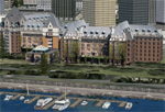
| Victoria Inner Harbor Airport (CYWH) |
|
Images related to this file:
File Description:
This airport was made using Airport Facilitator X, and Instant Scenery 2. Victoria Inner Harbor Airport is a water airport located in southern Victoria, British Columbia, Canada. The airlines that fly there are Harbor Air, West Coast Air, Kenmore Air, and Whistler Air. This is an airport that flight simulator does not have. I put docks for seaplanes with two seaplanes. I even made it so that you can start off at the dock. I made the small terminal and a parking lot with cars and light poles. I also put the surrounding docks with many boats. There is also a small heliport 0.73 miles away from Victoria Inner Harbor called Shoal Point Heliport. I have made this heliport because it too is another one flight simulator forgot. This was all based on Google Earth and Bing Maps. Please read the read me for instructions on how to install. This is for Flight Simulator X only. By Tyler Lawrence.
| Filename: | Victoria_Inner_Harbor_Airport_CYWH.zip |
| License: | Freeware |
| Added: | 16th January 2012, 23:53:12 |
| Downloads: | 1,488 |
| Author: | Tyler Lawrence |
| Size: | 9.98 MB |
| Category: Flight Simulator X - Scenery | |
| Wind power generators "erable" area, Quebec, Canada |
|
Images related to this file:
File Description:

Wind power generators project Saint-Ferdinand and Saint-Pierre-Baptiste. REQUIRES: qc38m_fsx_1de5.zip, qc38m_fsx_2de5.zip, qc38m_fsx_3de5.zip, qc38m_fsx_4de5.zip, qc38m_fsx_5de5.zip
| Filename: | Wind_power_generators_erable_area_Quebec_Canada.zip |
| License: | Freeware |
| Added: | 30th December 2011, 17:15:46 |
| Downloads: | 307 |
| Author: | Daniel Leclerc |
| Size: | 1.66 MB |
© 2001-2026 AVSIM Online
All Rights Reserved
Privacy Policy |