
Where Flight Simulation Enthusiasts Gather from Around the World!
AVSIM Library - Search Results

| Category: Flight Simulator X - Scenery | |
| Victoria Inner Harbor Airport (CYWH) |

|
Images related to this file:
File Description:
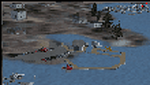
This airport was made using Airport Facilitator X, and Instant Scenery 2. Victoria Inner Harbor Airport is a water airport located in southern Victoria, British Columbia, Canada. The airlines that fly there are Harbor Air, West Coast Air, Kenmore Air, and Whistler Air. This is an airport that flight simulator does not have. I put docks for seaplanes with two seaplanes. I even made it so that you can start off at the dock. I made the small terminal and a parking lot with cars and light poles. I also put the surrounding docks with many boats. There is also a small heliport 0.73 miles away from Victoria Inner Harbor called Shoal Point Heliport. I have made this heliport because it too is another one flight simulator forgot. This was all based on Google Earth and Bing Maps. Please read the read me for instructions on how to install. This is for Flight Simulator X only. By Tyler Lawrence.
| Filename: | Victoria_Inner_Harbor_Airport_CYWH.zip |
| License: | Freeware |
| Added: | 16th January 2012, 23:53:12 |
| Downloads: | 1,488 |
| Author: | Tyler Lawrence |
| Size: | 9.98 MB |
| Category: Flight Simulator X - Utilities | |
| Logitech G940 Lighting Control Software |
|
Images related to this file:
File Description:
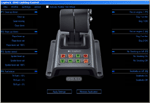
G940 Lighting Control Software for Flight Simulator X and Flight Simulator X: Accelerator
Introduction
G940 Lighting control Software lets you assign any of 28 Flight Simulator X events to the
eight panel buttons on the Logitech Flight System G940 Throttle. The events supported
are:
Fire on Engine 1, Fire on Engine 2, Fire on Engine 3, Fire on Engine 4, Damage Status Engine 1, Damage Status Engine 2, Damage Status Engine 3, Damage Status Engine 4, APU on Fire, Fuel Status, Avionics Master On/Off, Autopilot Master On/Off, Autopilot Flight Director On/Off, Flaps Up/Down, Spoiler Armed, Gear Up/Down, Exit open/Closed, Canopy Open/Closed, Tail Hook Up/ Down, Structure Iced, , Pitot Heater On/Off, Engine Anti Ice on/off, Pitot Iced, APU on/off, No Smoking on/off, Seatbelts On/Off, Nosewheel locked, Smoke On/Off, Set button Off, Set button Green, Set button Amber, Set button Red.
Buttons assigned to an event will change color when the event occurs. For example, if
Gear Up/Down is assigned. The button will light green when the gear are down and
locked. While the gear are in transition, the light is amber, and changes to red when the
gear are fully retracted.
| Filename: | Logitech_G940_Lighting_Control_Software.zip |
| License: | Freeware |
| Added: | 12th January 2010, 01:07:45 |
| Downloads: | 639 |
| Author: | Timo Hollwedel |
| Size: | 766.86 KB |
| Category: Flight Simulator X - Flight Plans | |
| Eastern Canada VFR Flights |
|
Images related to this file:
File Description:

Contains 9 GPS routes in sequence over interesting and rough terrain in Eastern Canada. The routes are VFR for site seeing. Low flight altitudes will give nice terrain views, on shapes and vastness around.
| Filename: | Eastern_Canada_VFR_Flights.zip |
| License: | Freeware |
| Added: | 4th April 2012, 20:49:48 |
| Downloads: | 918 |
| Author: | Tim van Ringen |
| Size: | 86.36 KB |
| Category: Flight Simulator X - Aircraft Repaints, Textures and Modifications | |
| Condor "HD Package" Boeing 767-330ER |
|
Images related to this file:
File Description:

This is an package of three current Condor liverys. One in normal colours, one with the new "Sunny Heart" and one with the "Janosch Sticker" at the front. All liverys are in High definition! This are textures only, for using you need the original Level-D 767-300 for Flight simulator X.
| Filename: | Condor_HD_Package_Boeing_767330ER.zip |
| License: | Freeware |
| Added: | 13th December 2013, 22:03:53 |
| Downloads: | 2,427 |
| Author: | Florian Hoffmann (CFG-Repaints) |
| Size: | 44.7 MB |
| Category: Flight Simulator X - Utilities | |
| SAC Flight System Version 8.0 |
|
File Description:
This a powerfull component for Flght Simulator 2004 and X more than 500 flights in
Brazil and International,Plans flight in more than 300 such flights on a simple
coding to be interpreted, Access directly FS9 and FSX directly by the program, calculation of fuel for each route and aircraft.Require Microsoft Access.
| Filename: | SAC_Flight_System_Version_80.zip |
| License: | Commercial demo |
| Added: | 3rd December 2007, 21:18:52 |
| Downloads: | 502 |
| Author: | Carlos Silveira |
| Size: | 876.07 KB |
| Category: Flight Simulator X - Aircraft Repaints, Textures and Modifications | |
| Project Fokker F100 Updated for FSX and P3D |
|
Images related to this file:
File Description:
This is an UNOFFICIAL update of this Fokker F100 made by Project Fokker (originally for FS2004). I make it work for Microsoft Flight Simulator X and Lockheed Martin Prepar3D. NO VC, just panel 2D with Honeywell FMC included. Model by Project Fokker. Panel 2D by Philippe Wallaert. FMC by Garrett Smith/Honeywell.
| Filename: | Project_Fokker_F100_Updated_for_FSX_and_P3D.zip |
| License: | Freeware |
| Added: | 20th May 2017, 18:29:36 |
| Downloads: | 2,082 |
| Author: | Leonardo Corrales |
| Size: | 25.83 MB |
| Category: Flight Simulator X - Utilities | |
| FS Earth 5.0 for Google Earth |
|
File Description:
This program acts as an interface between Flight Simulator X and Google Earth, letting to follow a flight in real time, over the satellite images generated by Google Earth. Flights can be saved, and many options are available for fine tuning the performance, as well as the map's style (zoom, tilt, orientation). Works on a single computer running FSX and Google Earth all together or, for best experience, can be used on two networked computers running respectively FSX (master) and Google Earth (slave). AI and Multiplayer traffic is also displayed in Google Earth, with course prediction and other information. Requires Flight Simulator X and Google Earth. The program running in trial mode works only around Anchorage, Alaska, (PANC / ANC) for a maximum of five minutes per flight session. Version 5.0 has improved compatibility with latest releases of Google Earth and several additional improvements. A version for FS2004 is available also.
| Filename: | FS_Earth_50_for_Google_Earth.zip |
| License: | Shareware, time limited |
| Added: | 19th July 2007, 00:46:27 |
| Downloads: | 1,104 |
| Author: | Luciano Napolitano |
| Size: | 2.44 MB |
| Category: Flight Simulator X - Utilities | |
| FS Earth 5.2 for Google Earth and FSX |
|
Images related to this file:
File Description:
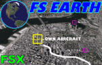
This program acts as a link between Flight Simulator X and Google Earth, letting to follow a flight in real time, over the satellite images generated by Google Earth. Flights can be saved, and many options are available for fine tuning the performance, as well as the map's style (zoom, tilt, orientation). Works on a single computer running FSX and Google Earth all together or, for best experience, can be used on two networked computers running respectively FSX (master) and Google Earth (slave). AI and Multiplayer traffic is also displayed in Google Earth, with course prediction and other information. Requires Flight Simulator X and Google Earth. The program running in trial mode works only around Anchorage, Alaska, (PANC / ANC) for a maximum of five minutes per flight session. Version 5.2 has new aircraft icons & labels and improves the compatibility with Windows Vista. A version for FS2004 is available also.
| Filename: | FS_Earth_52_for_Google_Earth_and_FSX.zip |
| License: | Shareware, time limited |
| Added: | 3rd May 2010, 07:38:23 |
| Downloads: | 2,701 |
| Author: | Luciano Napolitano |
| Size: | 3.46 MB |
| Category: Flight Simulator X - Utilities | |
| FS Earth 4.2 for Google Earth |
|
File Description:
This program acts as an interface between Flight Simulator X and Google Earth, letting to follow a flight in real time, over the satellite images generated by Google Earth. Flights can be saved, and many options are available for fine tuning the performance, as well as the map's style (zoom, tilt, orientation). Works on a single computer running FSX and Google Earth all together or, for best experience, can be used on two networked computers running respectively FSX (master) and Google Earth (slave). AI and Multiplayer traffic is also displayed in Google Earth, with course prediction and other information. Requires Flight Simulator X and Google Earth. The program running in trial mode works only around Anchorage, Alaska, (PANC / ANC) for a maximum of five minutes per flight session. Version 4.2 has improved compatibility with Windows Vista and minor bug fixes. A version for FS2004 is available also. By Luciano Napolitano.
| Filename: | FS_Earth_42_for_Google_Earth.zip |
| License: | Shareware, time limited |
| Added: | 9th March 2007, 13:39:05 |
| Downloads: | 2,213 |
| Author: | Luciano Napolitano |
| Size: | 2.44 MB |
| Category: Flight Simulator X - AFCAD Files | |
| Gibraltar AB |
|
File Description:
This file includes Gibraltar AB, for Flight Simulator X only!
I added a few fuel truck's, more parkings/gates and a few changes at the apron, taxiway's and runway. The airport does not include blast fences, the reason for that is because it doesn't look very good in FSX. Thanks for downloading and Happy Landings!
| Filename: | Gibraltar_AB.zip |
| License: | Freeware |
| Added: | 25th November 2007, 23:16:26 |
| Downloads: | 1,519 |
| Author: | Marcel Onderdelinden |
| Size: | 3.37 KB |
© 2001-2026 AVSIM Online
All Rights Reserved
Privacy Policy |