
Where Flight Simulation Enthusiasts Gather from Around the World!
AVSIM Library - Search Results

| Category: Flight Simulator X - Scenery | |
| INNSBRUCK-LOWI FSX VERSION |

|
File Description:
Scenery for the airport of Innsbruck - Tirol - Austria, FSX version.
Made with acceleration SDK, compatible with ultimate terrain Europe.
| Filename: | INNSBRUCKLOWI_FSX_VERSION.zip |
| License: | Freeware |
| Added: | 31st October 2009, 10:20:42 |
| Downloads: | 23,166 |
| Author: | Johan Thiers |
| Size: | 656.8 KB |
| Category: Flight Simulator X - Scenery | |
| Northeast New Jersey 5 Meter Mesh Terrain |
|
Images related to this file:
File Description:
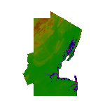
High Resolution Northeast New Jersey 5 Meter Mesh Terrain by Wally-Bob represents a significant improvement over FSX default 38 meter mesh terrain. The results are also dramatic compared to 10 meter compressed payware mesh as lossless compression compilation (read no data loss) is used. Lossless compiling produces renderings that have the Crispness of the Real World Terrain. Fly the Hudson River and view the Palisades as they are in real life, see the screen shots enclosed. High Quality 5 meter mesh terrain is a must have for mountainous areas especially where photo scenery is also used to render the virtual world. Manual includes FSX configuration and scenery installation tips. USGS LiDAR 1/9 Arc-Second source data.
| Filename: | Northeast_New_Jersey_5_Meter_Mesh_Terrain.zip |
| License: | Freeware, limited distribution |
| Added: | 26th February 2011, 21:35:52 |
| Downloads: | 1,100 |
| Author: | Walter Roberts |
| Size: | 135.89 MB |
| Category: Flight Simulator X - Scenery | |
| Doel PowerPlant Antwerp |
|
File Description:
Doel PowerStation (Nuclear power plant) Belgium.
EB00 (zero-zero)
The Power plant of Doel NW of Antwerp is one of the major landmarks for the southwest of the Netherlands and the northwest of Belgium.
The Powerplant is so huge that it’s plainly visible from EHLE (Lelystad) at 1500ft, about 150 -200 kilometers north in reality.
This scenery not only places the power plant correct in FSX corrected for Ultimate terrain X Europe, but it also adds several ships on the Schelde river and in port.
Have fun and happy landings.
| Filename: | Doel_PowerPlant_Antwerp.zip |
| License: | Freeware, limited distribution |
| Added: | 13th January 2009, 14:28:30 |
| Downloads: | 3,045 |
| Author: | Joost Visser / ADE |
| Size: | 284.79 KB |
| Category: Flight Simulator X - Scenery | |
| Bhutan Airports and Paro Valley |
|
Images related to this file:
File Description:
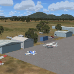
This project adds and updates all of the airports of Bhutan. Bathpalathang (VQBT) and Gelephu (VQGP) are added, Yongphulla (VQ10) is updated and recoded as VQTY, and Paro (VQPR) is fully updated to reflect current satellite imagery. These are all fully functioning AI airports as well. Special attention was given to the entire Paro Valley, and numerous road/river vectors were updated around Gelephu. Accurate coastlines, lakes, road and river data, as well as corrected landclass are provided based on the latest available satellite imagery. They are optimized to fit seamlessly with FTX Vector's roads/water, but they should be fully functional in all FSX configurations.
GA-encoded flight plans for the Buddha Air/Kathmandu charter are provided to enhance service to Paro. NASA SRTM Global 3 arc second terrain mesh is also included for all of Bhutan. Updates were created or rebuilt in a manner which carefully aligned airport data with current satellite imagery, when available. Scenery was created using Airport Design Editor X v1.61.5298, SBuilderX 3.13, and the FSX Object Placement Tool. Scenery objects were added and modified from stock FSX scenery to resemble as closely as possible the actual airports.
| Filename: | Bhutan_Airports_and_Paro_Valley.zip |
| License: | Freeware |
| Added: | 19th January 2015, 06:09:17 |
| Downloads: | 11,411 |
| Author: | Carlyle Sharpe |
| Size: | 21.4 MB |
| Category: Flight Simulator X - AFCAD Files | |
| LEMH Menorca |
|
File Description:
Modified ADE (Afcad) for LEMH, Menorca. Suitable for default scenery & also compatible with Ultimate Terrain Europe - uses only default library objects.
| Filename: | LEMH_Menorca.zip |
| License: | Freeware |
| Added: | 11th January 2010, 20:18:07 |
| Downloads: | 831 |
| Author: | Steve Morrell |
| Size: | 8.18 KB |
| Category: Flight Simulator X - Scenery | |
| Mid West Victoria UPDATED. 14 airports. YARA YSWL YMBU YSTA YDOD YWYF YBIR YHPN YKER YSLK YSWH + *NEW* YNHL YHML YWKB |
|
Images related to this file:
File Description:
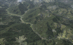
This is an updated version (original Jan 2018). Fixed some ground texture problems plus a lot of added and improved objects and 3 NEW airports. There are 14 airports starting at Ararat and extending up to the Murray at Swan Hill. YARA Ararat YSWL Stawell YMBU Maryborough YSTA Saint Arnaud YDOD Donald YWYF Wycheproof YBIR Birchip YHPN Hopetoun YKER Kerang YSLK Sealake YSWH Swanhill + *NEW* YNHL Nhill YHML Hamilton YWKB Warracknabeal. A lot of airports but not a quicky slap dash effort. It is several hundred hours over many months. Surrounding scenery modified to match real life. Towns, race courses, forests, sewage treatment ponds, obstacles (towers etc) have been added. Included is an AI traffic file that covers all airports that don't already have AI. These files are for Flight Simulator X. Made using Airport Design Editor using some objects borrowed from Robert Budd's excellent Baccus Marsh. RECOMMENDED The scenery is designed to interface with ORBX FTX_AU scenery for Australia (payware). It will work without ORBX but will not interface as well with standard scenery.
| Filename: | Mid_West_Victoria_UPDATED_14_airports_YARA__YSWL__.zip |
| License: | Freeware |
| Added: | 16th May 2019, 18:19:35 |
| Downloads: | 418 |
| Author: | Colin Jeffery |
| Size: | 5.23 MB |
| Category: Flight Simulator X - Miscellaneous Files | |
| Aerosoft Airbus X Extended A320/A321 Checklist v2.0 |
|
File Description:
Version two of my checklist for the Aerosoft Airbus X Extended A320/A321 aircraft for FSX. This version has a new design, and some edits regarding probe heat during takeoff. I included everything from the parking position, MCDU programming, engine starting, taxiing, taking off, climbing, cruising, descending, landing and shutting the aircraft down. I hope you find this checklist useful for your future flights on this aircraft!
| Filename: | Aerosoft_Airbus_X_Extended_A320A321_Checklist_v20.zip |
| License: | Freeware |
| Added: | 12th December 2014, 10:41:11 |
| Downloads: | 1,484 |
| Author: | Mike Charger |
| Size: | 2 MB |
| Category: Flight Simulator X - Scenery | |
| USA East 10 metre mesh, Batch 4, Part 3 of 9 |
|
File Description:
USA EAST USGS 10 metre mesh terrain - FSX only, includes: IA, MN, WI, IL, IN, MI, OH, PA, NY, VT, NH, ME, MA, CT, RI. Part 3 of 9!
This constitutes 10 metre terrain mesh for a section of the USA, The whole USA East mesh files will abutt the US West Coast 10m mesh already available elsewhere, that was made by: Raimondo Taburet. Make sure you have your scenery terrain settings at about 5 metres in the FSX display dialogue for the mesh to show properly!
| Filename: | USA_East_10_metre_mesh_Batch_4_Part_3_of_9.zip |
| License: | Freeware |
| Added: | 11th May 2009, 10:11:50 |
| Downloads: | 1,062 |
| Author: | Wayne Evans |
| Size: | 29.25 MB |
| Category: Flight Simulator X - Scenery | |
| USA East 10 metre mesh, Batch 4, Part 9 of 9 |
|
File Description:
USA EAST USGS 10 metre mesh terrain - FSX only, includes: IA, MN, WI, IL, IN, MI, OH, PA, NY, VT, NH, ME, MA, CT, RI. Part 9 of 9!
This constitutes 10 metre terrain mesh for a section of the USA, The whole USA East mesh files will abutt the US West Coast 10m mesh already available elsewhere, that was made by: Raimondo Taburet. Make sure you have your scenery terrain settings at about 5 metres in the FSX display dialogue for the mesh to show properly!
| Filename: | USA_East_10_metre_mesh_Batch_4_Part_9_of_9.zip |
| License: | Freeware |
| Added: | 11th May 2009, 10:18:22 |
| Downloads: | 1,020 |
| Author: | Wayne Evans |
| Size: | 28.84 MB |
| Category: Flight Simulator X - Scenery | |
| USA East 10 metre mesh, Batch 4, Part 5 of 9 |
|
File Description:
USA EAST USGS 10 metre mesh terrain - FSX only, includes: IA, MN, WI, IL, IN, MI, OH, PA, NY, VT, NH, ME, MA, CT, RI. Part 5 of 9!
This constitutes 10 metre terrain mesh for a section of the USA, The whole USA East mesh files will abutt the US West Coast 10m mesh already available elsewhere, that was made by: Raimondo Taburet. Make sure you have your scenery terrain settings at about 5 metres in the FSX display dialogue for the mesh to show properly!
| Filename: | USA_East_10_metre_mesh_Batch_4_Part_5_of_9.zip |
| License: | Freeware |
| Added: | 11th May 2009, 10:14:06 |
| Downloads: | 612 |
| Author: | Wayne Evans |
| Size: | 33.15 MB |
© 2001-2026 AVSIM Online
All Rights Reserved
Privacy Policy |