
Where Flight Simulation Enthusiasts Gather from Around the World!
AVSIM Library - Search Results

| Category: Flight Simulator X - Scenery | |
| Airport update for Ninoy Aquino Intl (RPLL) Manila, Philippines |

|
Images related to this file:
File Description:
This is a reasonably accurate and up-to-date version of NAIA Intl Airport with two optional files made only for FSX users, not made or suitable for use in P3D: There is one version with the Crosswind runway activated where both runways will be used for takeoff/landing and one version as the default airport one runway operation: I have given this airport a complete makeover including all 4 terminals, all gates/parking numbered correctly where possible, assigned parking as per their website with extra overflow parking, new control tower, aprons, taxiways and taxi signs updated to the latest charts, extra fuel trucks, support vehicle roads rebuilt and many other scenery improvements and objects added, airport views are from inside the new control tower (when in tower view) please view the readme before installation.
| Filename: | Airport_update_for_Ninoy_Aquino_Intl_RPLL_Manila_P.zip |
| License: | Freeware, limited distribution |
| Added: | 21st July 2021, 01:27:21 |
| Downloads: | 42,831 |
| Author: | Ray Smith |
| Size: | 2.76 MB |
| Category: Flight Simulator X - Scenery | |
| Dallas-Ft Worth Intl Airport (KDFW) Texas, USA (ILS fix for runway 18R/36L) |
|
Images related to this file:
File Description: *** Dedicated to my good friend Jim Vile, RIP Jim. ***
This is a very accurate version for KDFW to reflect today's situation with two optional files: one version with the Crosswind runways operating where all 7 runways will be used for takeoff/landing and one version as the default airport runway operation: assigned parking at all terminals now as per their website, extra parking including a gate for the A380 at Terminal D, start location added to the helipad, all ILS approaches, taxiways and taxi signs updated and corrected to the latest charts, extra fuel trucks, support vehicle roads rebuilt and many other scenery improvements and objects added, airport views are from inside the East control tower (when in tower view) please view the readme before installation.
| Filename: | DallasFt_Worth_Intl_Airport_KDFW_Texas_USA_ILS_fix.zip |
| License: | Freeware, limited distribution |
| Added: | 31st January 2017, 16:50:34 |
| Downloads: | 42,364 |
| Author: | Ray Smith |
| Size: | 3.11 MB |
| Category: Flight Simulator X - Aircraft Repaints, Textures and Modifications | |
| Douglas C-47 (VH-AGU) Adastra Aerial Surveys |
|
Images related to this file:
File Description:
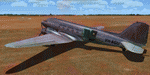
This folder contains a repaint for version 3.14 of the Douglas C-47 by Manfred Jahn and colleagues in the colors of C-47 VH-AGU of Adastra Aerial Surveys. It was originally constructed for the USAAF in 1944 as a C-47B-35-DK and allocated the military serial 44-76336. In February 1945 it was acquired by the RAAF and allocated the serial A65-72. Operated until 1959, it was then sold to Adastra Airways and converted for civil use. In October 1964 the aircraft was re-registered to Sepal Pty Ltd, but in October 1969 it was acquired by Adastra Aerial Surveys Pty Ltd. Adastra Aerial Surveys was acquired by East-West Airlines Ltd in April 1973 and VH-AGU was re-registered to East-West Airlines on 12 November 1974. East-West won the MLS trials support contract in December 1974 and VH-AGU was re-painted in East-West colours at Tamworth in the month prior to positioning at Melbourne/Essendon for the commencement of the contract on 25 January 1975. At some stage in the late 1970s the aircraft was transferred to South Coast Aviation, another East-West subsidiary. The aircraft was withdrawn from service in August 1979 at Essendon at the conclusion of its Departmental charter, and sold to Aerodyne Pty Ltd of Moorabbin. Since then, it has had several owners, and is still airworthy, flying in a USAF Vietnam war scheme from Morwell, Victoria. Repaint by Jan Kees Blom for Manfred Jahn's C-47 version 3.14, based on the paintkit by Gman5250.
| Filename: | Douglas_C47_VHAGU_Adastra_Aerial_Surveys.zip |
| License: | Freeware |
| Added: | 22nd August 2018, 15:12:21 |
| Downloads: | 192 |
| Author: | Jan Kees Blom |
| Size: | 15.68 MB |
| Category: Flight Simulator X - Scenery | |
| RAF Bircham Newton - Norfolk, England |
|
File Description:
RAF Bircham Newton is a former Royal Air Force station located 2.1 miles (3.4 km) south east of Docking, Norfolk
and 13.4 miles (21.6 km) north east of King's Lynn, Norfolk, England.
The site was first used during the First World War and received the largest British bomber of the time, the Handley Page V/1500. They would have carried out bombing missions against Berlin but the Armistice was arranged before any missions were actually flown.
The airfield was equipped with one aircraft repair shed and three double bay general service sheds, although these had been demolished by 1937. It had two Belfast hangars, three C Type hangars, three Bellman hangars and ten Blister hangars. It operated through the Second World War as part of No. 16 Group RAF as part of Coastal Command.
No. 206 Squadron RAF was one of the squadrons being based there, on maritime patrol duties. Two satellite airfields, RAF Docking and RAF Langham were opened to accommodate units. In 1965 the airfield was used for evaluation trials of the Hawker Siddeley Kestrel V/STOL aircraft.
After closure as an operational airfield in 1966, the airfield became the home of the Construction Industry Training Board. The runways have gone, but the majority of buildings on the site, including some hangars and the control tower, remain in use by the CITB.The control tower was demolished in 2010 due to its poor condition. Constructionarium is also based within the estate, providing a week's practical learning opportunity for undergraduates
| Filename: | RAF_Bircham_Newton__Norfolk_England.zip |
| License: | Freeware |
| Added: | 25th December 2015, 18:15:50 |
| Downloads: | 360 |
| Author: | Terry Boissel |
| Size: | 1.6 MB |
| Category: Flight Simulator X - Aircraft Repaints, Textures and Modifications | |
| B-24 USAAF 376th BG "Lady be Good" |
|
File Description:
Following an April 4, 1943 bombing raid on Naples, Italy, conducted by the 376th Bomb Group, the Lady Be Good of the 514th Bomb Squadron failed to return to base. After attempts to locate the plane, its nine crewmen were classified as MIA, and presumed dead, believed to have perished after crashing in the Mediterranean.
Almost 16 years later on Nov. 9, 1958, several British geologists were flying over the desolate, sun-baked Libyan Desert. At approximately 400 miles south of Soluch, they spotted an aircraft on the sand. A ground party that reached the site in March 1959 discovered the plane to be a B-24D. The "Lady Be Good" had been found.
Evidence at the site indicated that the crew had become lost in the dark on return from Naples and had flown over their base and southward into the desert. As their fuel supply became depleted, the nine men aboard had bailed out but had disappeared while attempting to walk northward to civilization.
Intensive searches were made for clues as to the fate of the crew, and in 1960 the remains of eight were found, one near the plane and the other seven far to the north. Five had trekked 78 miles across the tortuous sand before perishing and one had gone an amazing 109 miles. In addition, they had lived eight days rather than only two expected of men in this area with little or no water. The body of the ninth man was never found.
Repaint for the Alphasim B-24 by Jan Kees Blom.
| Filename: | B24_USAAF_376th_BG_Lady_be_Good.zip |
| License: | Freeware |
| Added: | 11th October 2008, 13:11:09 |
| Downloads: | 386 |
| Author: | Jan Kees Blom |
| Size: | 7.61 MB |
| Category: Flight Simulator X - AFCAD Files | |
| MRLB - Daniel Oduber Quiros International Airport / Liberia, Guanacaste, Costa Rica |
|
Images related to this file:
File Description:
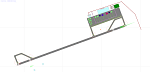
MRLB - Daniel Oduber Quiros International Airport / Liberia, Guanacaste, Costa Rica.
This airport update was made with the latest version of ADE (Airport Design Editor) and made for FSX as a replacement for the stock (default) airport. I found that most stock airports in FSX lack a decent amount of character and realism and I've tried to fix that a little bit. The stock airport file for the Liberia airport was sub par to say the least. There were absolutely no parking spots for commercial aircraft and no terminal buildings.
I've done major reworking to this airport and added the brand new terminal, which opened several months ago, I hope you enjoy. Below is a list of changes/additions. All these enhancements are as close to the real airport as I can get with stock library objects. I've used satellite images, terminal photos and maps throughout the whole process so building locations are as accurate as possible. Happy landings in Costa Rica!
Features:
*Greatly expanded parking apron
*Old terminal building added with GA parking area
*Brand new terminal building added with its 4 jetways and 3 additional ramp parking spots
*Parking lots with static vehicles
*Small current construction area
*Road that connects the airport to the main highway w/ static vehicles
*Hilton Garden Inn hotel south of runway 25
*Static vehicles and GA aircraft on the ramp
*Fire station
*Birds in the vicinity of the airport
| Filename: | MRLB__Daniel_Oduber_Quiros_International_Airport__.zip |
| License: | Freeware |
| Added: | 12th July 2012, 16:35:27 |
| Downloads: | 880 |
| Author: | Jaison Diaz |
| Size: | 7.63 KB |
| Category: Flight Simulator X - Scenery | |
| 2 Fronson Hangars |
|
Images related to this file:
File Description:
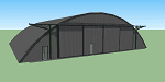
This model was created to be placed in FSX as airport scenery using Airport Design Editor.
I created it for my own use when i was re-creating RNAS HMS Nuthatch which was a Naval Airstation near Anthorn on the Solway Coast in Cumberland (now Cumbria), United Kingdom.
History of RNAS HMS Nuthatch...
Work began on building an airfield at Anthorn for the Fleet Air Arm in late 1943, with Royal Naval Air Station Anthorn, or HMS Nuthatch opening on 7 September 1944, with three tarmac runways.
It was the base of No. 1 Aircraft Receipt and Despatch Unit (No. 1 ARDU), which had the job of receiving aircraft fresh from manufacturers, modifying them to Service standards and despatching them to operational squadrons, with the unit specialising in the Vought F4U Corsair.
No. 1 ARDU continued to operate from Anthorn following the end of the Second World War, while a number of Fleet Air Arm Squadrons were also based at the airfield in the immediate post war years.
The airbase shut down in March 1958.
The Airfield is now the site of a VLF/LF transmitter used for transmitting orders to Submarines, it is also home to three atomic clocks for transmitting Britains time signal transmissions.
None of the Hangars (11 Pentad and 22 Fromson) survive at the site but their concrete standings are still visable.
Depicted here are representations of the Fromson type hangers created from dimensions in a 1947 survey.
I created the model using Google Sketchup and converted it for use in FSX using Model ConverterX.
This is my 1st attempt at scenery creation and is therefore pretty basic.
There are no known issues and it works fine in FSX.
| Filename: | 2_Fronson_Hangars.zip |
| License: | Freeware |
| Added: | 8th June 2014, 07:13:54 |
| Downloads: | 251 |
| Author: | Mark John Byers |
| Size: | 1.4 MB |
| Category: Flight Simulator X - Scenery | |
| Burke Lakefront Airport (KBKL), Clevland, Ohio |
|
Images related to this file:
File Description:

File Description:
This airport was made using Google sketch up 8, Airport Facilitator X and Instant Scenery 2. Burke Lakefront Airport is a general aviation airport located next to Lake Erie in Cleveland, Ohio. I have made custom 3D buildings using Google sketchup for the airport. This update makes it so that all the buildings will show because some people were having problems with the buildings. All the buildings have photo textures to make it closer to real life. The update also makes it so that the airport ICAO is not included in the airport name and an installer program is included. I put static aircraft on the ramp, airport vehicles and more fuel trucks. I added more parking and fuel spots. I also made a parking lot full of cars. If you choose to start off at a DOCK gate, you will start off inside one of the custom hangars. Starting off or taxiing inside of a hangar will cause a crash (unless you have crashes turned off). I added a helipad located near the FBO. I have also included the aviation high school, that is located at the northeast, and boats that are right next to it in the water. There will be more objects at the airport if your scenery complexity is set to normal (such as vehicles, aircraft, and fuel trucks). Tower view is from the roof of the control tower. This was all made based on Google Earth satellite imagery and Bing Maps. There are no night textures for the custom buildings. These will be added in a future version. Please read the readme for instructions on how to install. You do not need the original file for this update to work. This is for flight simulator X only. By Tyler Lawrence.
| Filename: | Burke_Lakefront_Airport_KBKL_Clevland_Ohio.zip |
| License: | Freeware |
| Added: | 7th April 2012, 11:42:42 |
| Downloads: | 1,347 |
| Author: | Tyler Lawrence |
| Size: | 6.82 MB |
| Category: Flight Simulator X - Scenery | |
| LGTS X 2014 - Thessaloniki Makedonia Airport |
|
Images related to this file:
File Description:

Eight years after the first scene the group of Greek airports Project invites you to travel in Thessaloniki which marked the route of the group in the area of Flight Simulator. The scene following the design of our philosophy which allows the simmer to enjoy a full scene without getting tired to find solutions which have to do with settings, yields etc, without unnecessary construction that nobody ever sees and which only need to create a commercial impression in some photos. Objects reconstructed with Gmax and 3dmax that make you enjoy your virtual trip to the airport, and not only because this time we have also included many points from the beautiful city of Thessaloniki as for example the known White Tower, the Aristotelous Square, the facilities of the Thessaloniki International Fair, the football stadiums of the best known groups, the opera house, the City Hall, and many others in a separate scenery (THESSALONIKI_VFR ) included in this version which you are not obliged to install but in our opinion will give you a different sensation in your approach to Macedonia airport. The THESSALONIKI_VFR also combined with the very good photoreal from Antonis Gikas state of GAP "Hellenic Actual Scenery" and with any other photoreal is circulated to the region. This photoreal version is currently for FS9 but very soon will follow and the version for FSX, P3DV1/P3DV2. Retained many of the features of the previous version as the transparent windows which give different feel on the inside part of the terminal, and replaced with different modern way. Of course for the FSX version corrected all non-compliant issues from FS9 - FSX. Enjoy free your flight for the magnificent Thessaloniki, in Greece, in Macedonia.
| Filename: | LGTS_X_2014__Thessaloniki_Makedonia_Airport.zip |
| License: | Freeware |
| Added: | 20th March 2014, 20:12:03 |
| Downloads: | 14,014 |
| Author: | GREEK AIRPORTS PROJECT - Team Chief: Michalis Triantafillou |
| Size: | 91.25 MB |
| Category: Flight Simulator X - Scenery | |
| Lago di Ginevra Places of particular VFR interest |
|
Images related to this file:
File Description:

Flying to the eastern end of Lake Geneva, you can admire the medieval castle of Chillon. The Manor stands on a rocky island connected to the mainland From a covered wooden bridge coordinates Geographic N 46.24.50 E 6.55.39. From here begins the most striking feature Of the lake, with the famous island of Peilz, a micro island with A single large platano tree in the center coordinates Geographic N 46.23.59 E 6.54.49. Tells the legend that twoLovers visited the island one of the two drowned and was born the plantain. Continuing the flight I realized the town of Corsier sur Vevey where is the residence of the great actor deceased Charlie Chaplin Geographic coordinates N 46.28.32 S 6.51.08. For more information on the site search on google. In the Package you will also find instructions for installing the scenery.
| Filename: | Lago_di_Ginevra_Places_of_particular_VFR_interest.zip |
| License: | Freeware |
| Added: | 27th August 2017, 19:02:17 |
| Downloads: | 517 |
| Author: | Pasquale Marrulli |
| Size: | 2.03 KB |


© 2001-2026 AVSIM Online
All Rights Reserved
Privacy Policy |