
Where Flight Simulation Enthusiasts Gather from Around the World!
AVSIM Library - Search Results

| Category: Flight Simulator X - Scenery | |
| British Columbia Floatbases |

|
Images related to this file:
File Description:
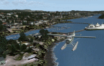
This is a collection of floatbases around the coast of British Columbia made with default scenery objects, and derived from Google Earth and the Canada Waterdrome Supplement. This scenery is designed to complement the work of others and therefore doesn't include waterdromes made by others such as Sidney Schwartz's CYYJ, Ganges Harbour and BCPNW Float Bases which covers an area around the Gulf Islands. You must have Ultimate Terrain Canada for these sceneries to work and in areas away from the immediate coast (Fraser River), a SRTM mesh for the correct elevations.
| Filename: | British_Columbia_Floatbases.zip |
| License: | Freeware |
| Added: | 16th May 2012, 14:02:09 |
| Downloads: | 1,537 |
| Author: | Chris Peschke |
| Size: | 183.32 KB |
| Category: Flight Simulator X - Scenery | |
| Falklands_2007 ** REPOST ** |
|
File Description:
Welcome to Falklands 2007 for Flight Simulator X.
This scenery has been released to commemorate the liberation of the Falkland Islands 25 years ago.
The scenery replaces the default mesh, landclass, coastlines and models with completely new and hand built components.
There are 325 ponds, not including the Black Tarn and Colorado ponds; my apologies if I have inadvertently missed out your favourite fishing hole!
There are 40 rivers.
There are 42 road segments.
There are 89 beaches.
There are 240 separate islands (not including the East and West Falklands themselves).
| Filename: | Falklands_2007__REPOST_.zip |
| License: | Freeware |
| Added: | 2nd June 2016, 15:40:58 |
| Downloads: | 1,912 |
| Author: | Brian Jamieson |
| Size: | 10.06 MB |
| Category: Flight Simulator X - Scenery | |
| NWT Landscape - Canada |
|
File Description:
Elevation data (mesh-Lod10 - 38m), land cover, water polygons, rivers, stream lines, lanes and shorelines around airports of Northwest Territories, Canada.
| Filename: | NWT_Landscape__Canada.zip |
| License: | Freeware, limited distribution |
| Added: | 9th February 2011, 17:43:21 |
| Downloads: | 3,349 |
| Author: | Gilles Gauthier |
| Size: | 89.42 MB |
| Category: Flight Simulator X - Scenery | |
| Horn Of Africa Mesh, part 2/3 |
|
Images related to this file:
File Description:
Part 2 of 3: Mesh (lod 1 to 9) of the "Horn Of Africa": Ethiopia, Erythrea, Djibouti and Somalia. (Re-upload)
| Filename: | Horn_Of_Africa_Mesh_part_23.zip |
| License: | Freeware, limited distribution |
| Added: | 10th June 2010, 08:59:50 |
| Downloads: | 2,093 |
| Author: | Marcel "Teutonique" Wislet |
| Size: | 88.72 MB |
| Category: Flight Simulator X - Scenery | |
| Horn Of Africa Mesh, part 3/3 |
|
Images related to this file:
File Description:

Part 3 of 3 : Mesh (lod 1 to 9) of the "Horn Of Africa": Ethiopia, Erythrea, Djibouti and Somalia. (Re-upload)
| Filename: | Horn_Of_Africa_Mesh_part_33.zip |
| License: | Freeware, limited distribution |
| Added: | 10th June 2010, 09:01:32 |
| Downloads: | 2,076 |
| Author: | Marcel "Teutonique" Wislet |
| Size: | 68.12 MB |
| Category: Flight Simulator X - Scenery | |
| Horn Of Africa Mesh, part 1/3 |
|
Images related to this file:
File Description:

Part 1 of 3: Mesh (lod 1 to 9) of the "Horn Of Africa": Ethiopia, Erythrea, Djibouti and Somalia. (Re-upload)
| Filename: | Horn_Of_Africa_Mesh_part_13.zip |
| License: | Freeware, limited distribution |
| Added: | 10th June 2010, 08:57:38 |
| Downloads: | 2,252 |
| Author: | Marcel "Teutonique" Wislet |
| Size: | 82.73 MB |
| Category: Flight Simulator X - Scenery | |
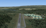
| KTEX - Telluride Regional Airport - Colorado, USA |
|
Images related to this file:
File Description:
East Coast Simulations presents scenery for Telluride Regional Airport (KTEX/TEX) for FSX/P3D! Telluride Regional Airport (IATA: TEX, ICAO: KTEX, FAA LID: TEX) is a public airport six miles west of Telluride, in San Miguel County, Colorado. It is owned by the Telluride Regional Airport Authority. At an elevation of 9,078 feet (2767 m) above sea level, it was the highest commercial airport in North America with scheduled passenger flights, until Great Lakes Airlines ended service in 2014. This scenery includes all custom buildings and terminals with a season changing photoreal background.
| Filename: | KTEX__Telluride_Regional_Airport__Colorado_USA.zip |
| License: | Freeware |
| Added: | 30th June 2015, 23:47:41 |
| Downloads: | 1,698 |
| Author: | Wesley Chin and Kyle Kato |
| Size: | 92.55 MB |
| Category: Flight Simulator X - Scenery | |
| Grand Central Airport, Johannesburg, South Africa _FAGC |
|
File Description:
This is Grand Central Airport in Johannesburg South Africa for FSX only.It also contains a modified AFCAD closer to the real thing.It is freeware and made from default FSX scenery librarys.Not the real thing but pretty close.Do not use it in FS9 as it will not work.
| Filename: | Grand_Central_Airport_Johannesburg_South_Africa__F.zip |
| License: | Freeware |
| Added: | 20th October 2008, 17:39:33 |
| Downloads: | 3,994 |
| Author: | Jacques Botha |
| Size: | 122.5 KB |
| Category: Flight Simulator X - Scenery | |
| FAKT - Kitty Hawk Airfield - Boschkop, South Africa |
|
Images related to this file:
File Description:
Kitty Hawk Aero Estate is a small airfield located east of Pretoria in the Boschkop area, South Africa. The strip is privately owned by the Kitty Hawk flying club and first opened in 1977. This scenery contains highly detailed buildings and hangars including a photo real base.
| Filename: | FAKT__Kitty_Hawk_Airfield__Boschkop_South_Africa.zip |
| License: | Freeware |
| Added: | 7th April 2013, 06:44:27 |
| Downloads: | 2,522 |
| Author: | Philip Schall, Aeroworx |
| Size: | 3.32 MB |
| Category: Flight Simulator X - Scenery | |
| Buenos Aires 2008 - Argentina |
|
File Description:
This is the scenery of "Buenos Aires", República Argentina. This Scenery was conceived from a principle with the following two objectives: 1) To achieve the best performance; 2) A real appearance of the land. The area that cover this Scenery is the following one: End of the Delta of Paraná, Coastal area from Buenos Aires, From Escobar's North, Until the South of Quilmes, Capital Federal, Area West, The routes arrive until Campana and La Plata, and much more. By Pablo Contouris.
| Filename: | Buenos_Aires_2008__Argentina.zip |
| License: | Freeware, limited distribution |
| Added: | 7th July 2008, 02:59:26 |
| Downloads: | 1,998 |
| Author: | Pablo Contouris |
| Size: | 8.72 MB |
© 2001-2026 AVSIM Online
All Rights Reserved
Privacy Policy |