
Where Flight Simulation Enthusiasts Gather from Around the World!
AVSIM Library - Search Results

| Category: Flight Simulator X - Scenery | |
| LGSO - Syros island v2 |

|
Images related to this file:
File Description:

New scenery of Syros island located in the Aegean sea. In this version there is no crash detection, ground is redesigned ,and some more modifications have been made.
| Filename: | LGSO__Syros_island_v2.zip |
| License: | Freeware |
| Added: | 25th February 2015, 22:59:49 |
| Downloads: | 1,863 |
| Author: | Moraitis Vaggelis |
| Size: | 6.56 MB |
| Category: Flight Simulator X - Scenery | |
| Tandragee airfield patch for UK2000 users |
|
Images related to this file:
File Description:

Patch for Tandragee/Kernan airfield for UK2000 scenery users. The code EGTA I have used for the strip although not in FSX actually exists and is depicted in the UK2000 airports scenery. If you have these airports installed apply this patch and you will be able to find Tandragee unfer the name "Kernan", city "Tandragee" and code "EG1". If you do not have UK2000 installed you do not need to apply this patch.
| Filename: | Tandragee_airfield_patch_for_UK2000_users.zip |
| License: | Freeware |
| Added: | 9th October 2014, 14:12:38 |
| Downloads: | 303 |
| Author: | Vassilios Dimoulas |
| Size: | 2.46 KB |
| Category: Flight Simulator X - Scenery Design | |
| Autogen Files For Payson, AZ |
|
File Description:
These are autogen files for Payson, Arizona. They require a photoreal scenery (which is not included) to be of any use to anyone. If you can make a photoreal scenery for Payson with FS EarthTiles, Ortho4XP for FSX/P3D, SbuilderX, etc. you can use these files to add autogen buildings and trees to your resulting photoreal. Autogen was generated with scenProc. Source files are included for educational purposes and/or to facilitate modification.
| Filename: | Autogen_Files_For_Payson_AZ.zip |
| License: | Freeware, limited distribution |
| Added: | 14th September 2020, 19:02:04 |
| Downloads: | 58 |
| Author: | Jim Robinson |
| Size: | 33.36 MB |
| Category: Flight Simulator X - Scenery | |
| BCATP (British Commonwealth Air Training Plan) Canada 1940s |
|
Images related to this file:
File Description:
This British Commonwealth Air Training Plan (BCATP) scenery will install approximately 160 BCATP stations across Canada and they will resemble what they appeared like in the 1940s. You will see an abundance of aircraft from that era and the buildings were produced in GMax from drawings used when those stations were operational. The scenery will be self installed. Start your favourite Harvard, Tiger Moth or Anson and take yourself back in history to WWII.
| Filename: | BCATP_British_Commonwealth_Air_Training_Plan_Canad.zip |
| License: | Freeware, limited distribution |
| Added: | 2nd August 2011, 15:40:25 |
| Downloads: | 616 |
| Author: | Flight Ontario, Al Gay, Grant Wilson |
| Size: | 46.43 MB |
| Category: Flight Simulator X - Scenery | |
| Cape Girardeau Regional Airport |
|
Images related to this file:
File Description:
FSX Scenery - Cape Girardeau Regional Airport (IATA: CGI, ICAO: KCGI) is a public airport located five miles (8 km) southwest of the central business district (CBD) of Cape Girardeau, a city in Cape Girardeau County, Missouri, USA. The airport covers 557 acres (225 ha) and has two runways. It is used for general aviation. Created using Instant Scenery. Libraries listed. Created With assistance from David "Opa" Marshall, by John B. Loney, Jr.
| Filename: | Cape_Girardeau_Regional_Airport.zip |
| License: | Freeware, limited distribution |
| Added: | 27th February 2011, 04:41:31 |
| Downloads: | 692 |
| Author: | John B. Loney, Jr. |
| Size: | 5.85 MB |
| Category: Flight Simulator X - Scenery | |
| SVGU Guanare, Venezuela |
|
Images related to this file:
File Description:
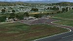
The Coromoto National Airport serves to Guanare's city, to the west of Venezuela.
Currently this airport is not operating for commercial aviation.
With photo-terrain scenery from satellite imagery of Google Earth.
Photo-terrain area improved with Autogen files.
Not compatible with versions prior to FSX.
This scenery requires SP1, SP2, or the Acceleration
expansion pack in order to be displayed correctly.
Also includes a friendly Auto-Install.
| Filename: | SVGU_Guanare_Venezuela.zip |
| License: | Freeware |
| Added: | 6th October 2013, 17:28:27 |
| Downloads: | 1,275 |
| Author: | David Maldonado |
| Size: | 70.66 MB |
| Category: Flight Simulator X - Scenery | |
| (SVPA) Puerto Ayacucho Airport - Venezuela |
|
Images related to this file:
File Description:
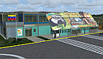
Low-capacity airport mostly used by tourist agencies with
locations in Amazonas state, although it's used as a terminal
for the armed forces and security agencies of the state due
to its proximity to the Colombian border
With photo-terrain scenery from satellite imagery
of Yahoo Satellite.
Not compatible with versions prior to FSX.
This scenery includes terminal building with realistic
textures from images obtained from Internet.
Also includes a friendly Auto-Install.
| Filename: | SVPA_Puerto_Ayacucho_Airport__Venezuela.zip |
| License: | Freeware |
| Added: | 6th August 2012, 18:16:00 |
| Downloads: | 1,795 |
| Author: | David Maldonado |
| Size: | 54.73 MB |
| Category: Flight Simulator X - Scenery | |
| CreteWest |
|
Images related to this file:
File Description:
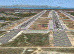
AS REAL AS IT GETS.
This is a detailed photorealistic scenery of the western half of the island of Crete.
Default FSX airports of Chania (LGSA) and Tympaki (LG54) were completely redone, positioned to their exact location, and many buildings and objects were added in the airport compounds.
New aprons, taxi signs and plenty of aircraft parking.
The scenery contains plenty of autogen objects, buildings, vegetation.
I have also included 2 aircraft traffic files.
| Filename: | CreteWest.zip |
| License: | Freeware |
| Added: | 8th October 2011, 02:58:37 |
| Downloads: | 2,838 |
| Author: | Angelo Tassoglou |
| Size: | 223.4 MB |
| Category: Flight Simulator X - Scenery | |
| Ireland EIKN Knock Airport |
|
File Description:
Ireland West Airport Knock is a small airport on the West coast of Ireland. The runway is 7,500feet in length and has landed 747's in comfort. In 2010, passenger numbers were almost 600,000. The scenery includes custom buildings, aircrew, default and custom vehicles with specular shine and reflections. It also includes sound effects and some animations. Parts of the scenery can be switched on or off according to user preference. Please enjoy.
| Filename: | Ireland_EIKN_Knock_Airport.zip |
| License: | Freeware |
| Added: | 26th October 2011, 01:53:46 |
| Downloads: | 4,971 |
| Author: | George Keogh |
| Size: | 53.93 MB |
| Category: Flight Simulator X - AFCAD Files | |
| Cleveland-Hopkins International Airport - KCLE |
|
Images related to this file:
File Description:
KCLE is a modification to the default FSX scenery. Among the many changes is the inclusion of new ILS, RNAV(GPS) and NDB approaches with transitions and missed approaches per the most current plates. Rwy 6C-24C decommissioned and 6R-24L extended with new taxiways. Custom Terminal airline assignments per 2009 specifications. Both visual and non-visual parts of this scenery have been updated. Please see the readme file for additional changes and installation instructions.
| Filename: | ClevelandHopkins_International_Airport__KCLE.zip |
| License: | Freeware |
| Added: | 3rd November 2009, 11:33:22 |
| Downloads: | 1,368 |
| Author: | Kambiz Agazi |
| Size: | 1.12 MB |
© 2001-2026 AVSIM Online
All Rights Reserved
Privacy Policy |