
Where Flight Simulation Enthusiasts Gather from Around the World!
AVSIM Library - Search Results

| Category: Flight Simulator X - Scenery | |
| KHOT - Memorial Springs Airport - Arkansas, USA |

|
Images related to this file:
File Description:
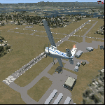
This scenery is an ADE update of the layout at Memorial Springs Airport in Arkansas, USA. This includes, updated parking spots, Adjusted Runway positions and length, Taxiways edited and Added, added buildings, relocation of some objects such as the ILS Transmitter for Runway 23/05 and The VOR, Checkershed and much more. I've tried to make this scenery as realistic as possible with the resources I have. If you have any contributions (e.g. pictures of the Airfield) please don't hesitate to contact me so I can update the Scenery. This is effectively version 1.0 of the scenery. Tested with FSX w/ SP2.
| Filename: | KHOT__Memorial_Springs_Airport__Arkansas_USA.zip |
| License: | Freeware |
| Added: | 23rd November 2015, 14:34:53 |
| Downloads: | 252 |
| Author: | Morgan Thomas |
| Size: | 3.96 MB |
| Category: Flight Simulator X - Scenery | |
| 2B3 Parlin Field, Newport, New Hampshire Airport |
|
Images related to this file:
File Description:
This airport was originally released as part of an FSX airport scenery package containing 21 airports, located in New Hampshire and Vermont. The link to the original 21 New Hampshire & Vermont Airport package is shown below. This file is not required, but allows you to download 21 related airports.
The 2B3 Parlin Field airport in the original 21 airport package was missing a required scenery file which corrects the airport altitude (from 784 ft. to 794 ft.) due to the mis-location of the stock FSX airport. This download provides all three of the required .bgl scenery files.
related download:
http://library.avsim.net/search.php?SearchTerm=new+hampshire+%26+Vermont+airports&CatID=root&Go=Search
This FSX scenery package contains the 2B3 Parlin Field airport in Newport, New Hampshire. This airport is intended to be used with FSX and the free addon - TileProxy. TileProxy provides real-time photorealistic satellite imagery in place of the stock auto generated FSX scenery or any other scenery package.
| Filename: | 2B3_Parlin_Field_Newport_New_Hampshire_Airport.zip |
| License: | Freeware |
| Added: | 2nd December 2013, 05:36:38 |
| Downloads: | 531 |
| Author: | John Greenwood |
| Size: | 631.59 KB |
| Category: Flight Simulator X - Scenery | |
| MMTJ - Gen Abelardo L Rodriguez Intl - Tijuana, Mexico ----- KSDM - Brown Mun - San Diego, California - USA |
|
Images related to this file:
File Description:
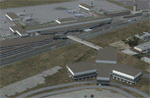
This scenery adds the new Cross Border Xpress (CBX) terminal to MMTJ, which opened on December 9, 2015, making it the first airport in the world to have connecting terminals in two different countries. All of MMTJ is also updated to reflect the most current airport layout. The neighboring KSDM is also completely updated and included in this scenery package. This scenery is optimized to fit seamlessly with FTX Global/Vector and also includes an optional CVX file which adds roads for default FSX users. All elements of both airports were traced directly from current satellite imagery and updated to reflect current satellite positioning. Scenery was created using Airport Design Editor X v1.61.5298, SBuilderX 3.13, and the FSX Object Placement Tool. Scenery objects were added and modified from stock FSX scenery to resemble as closely as possible the actual airports. The FSX apron lights included are from the set created by Jim Dhaenens.
| Filename: | MMTJ__Gen_Abelardo_L_Rodriguez_Intl__Tijuana_Mexic.zip |
| License: | Freeware |
| Added: | 3rd January 2016, 12:58:36 |
| Downloads: | 2,682 |
| Author: | Carlyle Sharpe |
| Size: | 3.58 MB |
| Category: Flight Simulator X - AFCAD Files | |
| Robert J. Miller Air Park Airport (KMJX), NJ |
|
File Description:
Located 05 miles SW of Toms River, New Jersey on 232 acres of land, R.J. Miller Air Park is a public asphalt strip 5949' in length. The airport buildings and immediate surrounding area have been included, magnetic variation adjusted, PAPI properly placed, taxiway lines drawn accurately, beacon properly placed, lit winsock and wind tee (both functional). The parking available has been matched to the current configuration of the airport, which is still undergoing renovation. Not included is the under-construction building just to the south of the terminal and the additional large hangar just north of the already-existing one. Taxiway lighting could not be seen in aerial photos - complete liberty on behalf of the author was taken when placing taxiway lights. Helipad is lit at night although the real world pad is not. Tiedown parking is available on the main tarmac in three sections: Southwest, Northeast, and regular Parking which is in the middle. RAMP_GA_SMALL parking spots are for aircraft with wingspans no greater than 40 feet. RAMP_GA_MEDIUM parking spots are for aircraft with wingspans no greater than 60 feet. RAMP_GA parking spots are occupied/blocked by static objects and should not be chosen as a start location (although collision detection with all such objects has been disabled). There are 4 open hangars - three to the Southwest are for RAMP_GA_SMALL aircraft while the Northeast one is for RAMP_GA_MEDIUM aircraft or smaller. All hangar parking spots are labeled DOCK_GA. A hangar on the main tarmac and a hangar on the tarmac to the south and west removed from the airport have attendants that can be called on NAV2 - this appears to be FS9 only. Both hangars have undecorated interiors and no parking spots to start from. There is only one helipad to start on but helicopters can also start in any RAMP_GA_MEDIUM location with no problem. Fuel for aircraft/helicopters is available by stopping next to the fuel pumps (not the fuel tank) at the north end of the main tarmac. The helipad will supply fuel when landed on.
Scenery constructed with use of satellite images/streetview/aerial photos - the author has not been there in person.
This scenery is meant to be used in conjunction with MegaScenery Earth New Jersey/Delaware 002. It is not required, but apron use is minimized to allow satellite scenery to show through as much as possible, and objects are placed based on the MSE textures - lack of it may make scenery look out of place.
| Filename: | Robert_J_Miller_Air_Park_Airport_KMJX_NJ.zip |
| License: | Freeware |
| Added: | 4th August 2011, 21:45:08 |
| Downloads: | 372 |
| Author: | Drew Sikora |
| Size: | 2.22 MB |
| Category: Flight Simulator X - Miscellaneous Files | |
| FsGoogleEarthView v3.0 |
|
Images related to this file:
File Description:

FsGoogleEarthView enables Flight Simulator flight with realistic Google Earth view! With FsGoogleEarthView, you can take both - Google Earth's great photoreal ground, 3D Buildings, detailed terrain mesh and Flight Simulator's great flight model, flight instruments, add-on aircrafts, add-on airport sceneries - with no downloading and very short loading time, anywhere in the world! It will provide more enjoyable VFR flight than any other sceneries. Now with v3.0, additional functions such as VDGS, Landing Report, Airport Moving Map, Route Visualization and Flight Logging are also included. And it's freeware now. It works with FSX, FS2004, Prepar3d, X-plane all.
| Filename: | FsGoogleEarthView_v30.zip |
| License: | Freeware, limited distribution |
| Added: | 5th May 2017, 19:08:37 |
| Downloads: | 2,748 |
| Author: | Dongjin Shin |
| Size: | 14.9 MB |
| Category: Flight Simulator X - Aircraft Repaints, Textures and Modifications | |
| FSX-SP2 compatible BAC 1-11-200 |
|
Images related to this file:
File Description:
FSX-SP2 compatible BAC 1-11-200. Dee Waldron's
freeware FS2002/FS2004 BAC 1-11-200 for AI made
compatible and flyable in FSX-SP2 with Steven
Persson's freeware PWJT8D sound and Pasquale
Rinaldi's freeware MD-90 panel (no VC). Repainted
in the real world International Air Transport
Association's fictional livery, the Miami
Regional Office's fictional BAC 1-11 flies the
Caribbean and Central America working to keep
various airline's and government's aviation endeavors
all playing on the same page. Landing gear contact
points adjusted and engine smoke added. Easy
installation. Painted, adjusted, smoked, and compiled
by Tom Tiedman.
| Filename: | FSXSP2_compatible_BAC_111200.zip |
| License: | Freeware |
| Added: | 3rd March 2011, 20:22:31 |
| Downloads: | 199 |
| Author: | Tom Tiedman |
| Size: | 45.37 MB |
| Category: Flight Simulator X - Original Aircraft | |
| Messerschmitt "Amerika" ME-264 |
|
Images related to this file:
File Description:
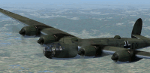
WW2 4-engine heavy bomber. Nazi Germanys only attempt to build a transcontinental strategic bomber. Was called "America Bomber" or "New York Bomber" by german propaganda. Only one prototype completed and destroyed by allied bomb raid before it went into service in 1944. Complete package with model, 2D Panel, VC and custom effects but uses default soundset. Build and tested with P3D Sdk for FSX SP2, FSX ACC and P3d only. Does not work with FSX basic or FSX SP1. Includes prototype with both engine versions and one fictional model in bomber role. Alll three with or without wingview option.
| Filename: | Messerschmitt_Amerika_ME264.zip |
| License: | Freeware |
| Added: | 20th August 2013, 21:26:39 |
| Downloads: | 3,972 |
| Author: | Thomas Ruth |
| Size: | 69.06 MB |
| Category: Flight Simulator X - Scenery | |
| YCDN Corunna Downs Station and Old Corunna Downs RAAF (Closed) |
|
File Description:
Corunna Downs heritage listed RAAF Base was a secret airfield located in scrub and spinifex country, about 16 kms south west of Marble Bar, the hottest part of the "The Pilbara" area of Western Australia. Not a very ideal place to have a tent city. Today there are very few reminders of the once busy airfield. One can see some crumbling foundations and half filled post holes. 73 OBU operated the Corunna Downs airfield which comprised two intersecting bitumen runways, now regressed and graded occasionally. One ran approximately north-south, 5,000 feet in length while the other ran approximately east-west, 7,000 feet in length. Both runways were approximately 150 feet wide. A 50 foot wide taxiway linked the northern end of the north-south runway to the western end of the east-west runway. Approximately 20 camouflaged revetments to disperse aircraft to minimise bomb damage were constructed at Corunna Downs. Permission is required for landing and there may be vegetation on the strip if not graded recently. No cones or windsock so be careful. Corunna Downs Homestead is also heritage listed and consists of graded strips and homestead complex. Start points are at the homestead and the RAAF base is to the west. REQUIRES Blencowe_LibraryKit.zip
REQUIRES blencowe_librarykit_309494.zip (Available HERE)
| Filename: | YCDN_Corunna_Downs_Station_and_Old_Corunna_Downs_R.zip |
| License: | Freeware |
| Added: | 25th February 2013, 08:59:42 |
| Downloads: | 283 |
| Author: | Alan Blencowe |
| Size: | 4.92 MB |
| Category: Flight Simulator X - Scenery | |
| Daytona Beach, FL (KDAB) V3 |
|
Images related to this file:
File Description:
Since I last completed and uploaded scenery for KDAB, hangers have been added, FBOs have changed hands and the Embry Riddle Aeronautical University flight line buildings have been demolished in preparation for new construction.
The last scenery I did was labeled Daytona_Beach_FL_redone in the AVSIM library. Much of what is included in that scenery has been, well, redone in this scenery. All is as currently exists at KDAB, except the Embry Riddle flight line buildings are based on models for the proposed new construction just getting underway. All generic/default buildings have been replaced, including the terminals. This scenery runs smoothly on a high-performance computer but may not work well on a lower performing computer due to the amount of complexity.
Requires 'Daytona_Beach_FL_redone.zip' from the AVSIM library.
| Filename: | Daytona_Beach_FL_KDAB_V3.zip |
| License: | Freeware |
| Added: | 19th March 2010, 11:31:28 |
| Downloads: | 4,340 |
| Author: | Art Poole |
| Size: | 2.74 MB |
| Category: Flight Simulator X - AFCAD Files | |
| B J Farms Airport (NJ06), NJ |
|
File Description:
Located 03 miles E of Shiloh, New Jersey, B J Farms Airport is an undefined grass strip 1500' in length. Because it is not a visible strip, this scenery removes the default grass runway that is located there. If you are looking to visit this area, JY17 is less than 1 mile away. (http://www.mseairports.com/index.php?page_id=781)
Scenery constructed with use of satellite images/streetview/aerial photos - the author has not been there in person.
This scenery is meant to be used in conjunction with MegaScenery Earth New Jersey/Delaware 004. It is not required, but apron use is minimized to allow satellite scenery to show through as much as possible, and objects are placed based on the MSE textures - lack of it may make scenery look out of place.
| Filename: | B_J_Farms_Airport_NJ06_NJ.zip |
| License: | Freeware |
| Added: | 14th June 2011, 02:15:45 |
| Downloads: | 163 |
| Author: | Drew Sikora |
| Size: | 179.16 KB |


© 2001-2026 AVSIM Online
All Rights Reserved
Privacy Policy |