
Where Flight Simulation Enthusiasts Gather from Around the World!
AVSIM Library - Search Results

| Category: Flight Simulator X - AFCAD Files | |
| OMDW - Al Maktoum Intl - Dubai, UAE |

|
Images related to this file:
File Description:
Al Maktoum International Airport (ICAO: OMDW) is an international airport in Jebel Ali, 37 kilometres south west of Dubai, United Arab Emirates that opened on 27 June 2010. It is the main part of Dubai World Central, a planned residential, commercial and logistics complex.
Using ADEx 1.66, aeronautical maps and Google Earth this new airport was built from scratch.
| Filename: | OMDW__Al_Maktoum_Intl__Dubai_UAE.zip |
| License: | Freeware |
| Added: | 22nd May 2015, 10:36:02 |
| Downloads: | 2,746 |
| Author: | Menno C. Robert |
| Size: | 1.29 MB |
| Category: Flight Simulator X - Scenery | |
| LXGB v3, Gibraltar Airport |
|
Images related to this file:
File Description:
A 3rd revision of this completely new setup. Many call Gibraltar Airport a dangerous airport because of the winds that can blow around the famous Gibraltar Rock. The Gibraltar Rock is the very south end of the Spanish peninsula, and since 1713 assigned to the British by the 'Vrede van Urecht'. It is an important Royal Navy base.
| Filename: | LXGB_v3_Gibraltar_Airport.zip |
| License: | Freeware |
| Added: | 24th January 2018, 23:24:05 |
| Downloads: | 7,237 |
| Author: | Tim van Ringen |
| Size: | 1.12 MB |
| Category: Flight Simulator X - Aircraft Repaints, Textures and Modifications | |
| Cessna 172 |
|
File Description:
This is a repaint for the A2A Cessna 172 aircraft.
Featuring a real world training aircraft in South Africa with the following registration mark ZS-SMB.
Kindly note that the livery has only been tested in Flight Simulator X, I would appreciate if someone tests it on P3D & provide feedback on the email address included in the readme document.
| Filename: | Cessna_172.zip |
| License: | Check within download |
| Added: | 24th March 2020, 22:22:03 |
| Downloads: | 101 |
| Author: | M. Anas Sayed |
| Size: | 19.67 MB |
| Category: Flight Simulator X - Flight Plans | |
| iFly 737NG Flight Plan for Louis Armstrong International Airport - McGhee Tyson Airport |
|
File Description:
This file contains information for the route for a flight between New Orleans, Louisiana and
Alcoa Tennessee and 12 miles south of Knoxville,Tennesseefor the iFly 737NG using the following
airports:Louis Armstrong International Airport and McGhee Tyson Airport
Departure:Louis Armstrong International Airport
IATA:MSY
ICAO:KMSY
FAA LID:MSY
WMO:72231
Destination:McGhee Tyson Airport
IATA:TYS
ICAO:KTYS
FAA LID:TYS
WMO:72326
| Filename: | iFly_737NG_Flight_Plan_for_Louis_Armstrong_Interna.zip |
| License: | Freeware |
| Added: | 25th March 2025, 18:12:25 |
| Downloads: | 4 |
| Author: | David M. Long |
| Size: | 2.15 KB |
| Category: Flight Simulator X - Original Aircraft | |
| Pacific Aerospace Corporation Cresco |
|
Images related to this file:
File Description:
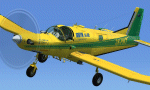
The Cresco was designed as a turboprop powered aerial topdressing aircaft, for operations in New Zealand. It is based on the FU24 Fletcher. Package includes fully animated and detailed virtual cockpit,topdressing effects and paint schemes for Rangitikei Air Services, Wanganui Aero Work Central South Island Helicopters, Farmers Air, Griffin Ag Air and Taumarunui Aerial Co-op.
| Filename: | Pacific_Aerospace_Corporation_Cresco.zip |
| License: | Freeware, limited distribution |
| Added: | 1st February 2011, 10:17:50 |
| Downloads: | 7,880 |
| Author: | Deane Baunton |
| Size: | 52.15 MB |
| Category: Flight Simulator X - Scenery | |
| RAF Lindholme (1940s) |
|
File Description:
RAF Lindholme is located 3.9 miles (6.3 km) south of Thorne and 6.9 miles (11.1 km) north east of Doncaster and was initially called RAF Hatfield Woodhouse and started life as an
expansion scheme aerodrome built on the wide expanse of Hatfield moors, some five miles east of Doncaster. The site, to the east of the A614 Thorne to Bawtry road, was a mile
south of the small village of Hatfield Woodhouse, the name first selected for the new station. Work began in the spring of 1938 taking in approximately 250 acres (1.0 km2) of
pasture for the airfield itself and a further 150 for the camp and support facilities.
RAF lindholme had a long a varied career, details of which cam be found at:- https://en.wikipedia.org/wiki/RAF_Lindholme
Source:Wikipedia
| Filename: | RAF_Lindholme_1940s.zip |
| License: | Freeware |
| Added: | 4th March 2017, 19:57:23 |
| Downloads: | 87 |
| Author: | Terry Boissel |
| Size: | 1.24 MB |
| Category: Flight Simulator X - AFCAD Files | |
| Manchester EGCC AFCAD |
|
File Description:
This scenery lines up the Manchester AFCAD with the Horizon VFR scenery, although it can be used with the default scenery as well. It adds extra gates and taxiways to Manchester. The runway numbers are updated from FSX to their real world numbers 05L/23R and 05R/23L. All gates are coded to allow traffic to park in the correct places.
| Filename: | Manchester_EGCC_AFCAD.zip |
| License: | Freeware, limited distribution |
| Added: | 3rd October 2007, 12:38:59 |
| Downloads: | 1,398 |
| Author: | Leo Allan |
| Size: | 137.84 KB |
| Category: Flight Simulator X - Scenery | |
| Eastern Sierra Regional Airport (KBIH) |
|
File Description:
This is a scenery update for Estern Sierra Regional airport. Taxiways, runways, aprons, were resized and moved to their real-world locations. Buildings were also moved and adjusted. Satellite images from Google Earth were used for accuracy. Many default scenery objects were placed from the FSX scenery libraries. View Readme file for installation and notes. Compiled using Airport Design Editor.
| Filename: | Eastern_Sierra_Regional_Airport_KBIH.zip |
| License: | Freeware |
| Added: | 19th December 2008, 00:06:43 |
| Downloads: | 537 |
| Author: | Phillip Coyle |
| Size: | 322.59 KB |
| Category: Flight Simulator X - Scenery | |
| Willows-Glenn County Airport (KWLW) |
|
File Description:
This is a scenery update for Willows-Glenn County Airport. Taxiways, runways, aprons, were resized and moved to their real-world locations. Buildings were also moved and adjusted. Satellite images from Google Earth were used for accuracy. Many default scenery objects were placed from the FSX scenery libraries. View Readme file for installation and notes. Compiled using Airport Design Editor.
| Filename: | WillowsGlenn_County_Airport_KWLW.zip |
| License: | Freeware |
| Added: | 2nd March 2009, 00:15:20 |
| Downloads: | 433 |
| Author: | Phillip Coyle |
| Size: | 261.4 KB |
| Category: Flight Simulator X - Scenery | |
| Enniskillen St Angelo (EGAB) |
|
Images related to this file:
File Description:
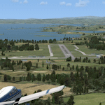
FSX scenery for Enniskillen Airport (St. Angelo - EGAB) and Lower Lough Erne in County Fermanagh, Northern Ireland. This scenery replaces the default single runway and a fuel pump that represents Enniskillen Airport and adds the totally missing Lower Lough Erne to the sim (this can be deleted if using UTX Europe). Uses only default objects and scenery at this version.
| Filename: | Enniskillen_St_Angelo_EGAB.zip |
| License: | Freeware, limited distribution |
| Added: | 4th July 2010, 22:00:30 |
| Downloads: | 1,166 |
| Author: | Ian Pearson |
| Size: | 33.93 KB |


© 2001-2026 AVSIM Online
All Rights Reserved
Privacy Policy |