
Where Flight Simulation Enthusiasts Gather from Around the World!
AVSIM Library - Search Results

| Category: Flight Simulator X - Scenery | |
| CYSV Saglek, New Foundland, Canada |

|
File Description:
This scenery as much as possible represents Saglek (CYSV), located at the north of New Foundland, Canada according to photographs found on the Web. This scenery is compatible with Mesh de M.Gilles Gauthier. Several originators took part in the design of this scenery: Regis Dassylva, Gerald Allaire, Gilles Gauthier and Jean-Pierre Fillion, all members of Concepteurs Virtual du Quebec.
| Filename: | CYSV__Saglek_New_Foundland_Canada.zip |
| License: | Freeware |
| Added: | 4th December 2009, 02:12:36 |
| Downloads: | 1,118 |
| Author: | Regis Dassylva |
| Size: | 8.5 MB |
| Category: Flight Simulator X - Scenery | |
| Santa Cruz de la Sierra - Bolivia |
|
File Description:
Scenery Photoreal: Santa Cruz de la Sierra, Bolivia
Santa Cruz de la Sierra: (English: Holy Cross of the Mountain Range), commonly known as Santa Cruz, is the
capital of the Santa Cruz department in eastern Bolivia (17 45', South, 63 14', West)at 416 m above sea level.
The city of Santa Cruz is located not far from the easternmost extent of the Andes Mountains and they are
visible from some parts of the city its Situated too on the Pirai River.
The city of Santa Cruz and its metropolitan area are home to over 70% of the population of the department and
it is one of the fastest-growing cities in the world.
Airports: (NOT included in this package, just Scenery Photoreal of the city)
Viru Viru International Airport (IATA: VVI, ICAO: SLVR) in Santa Cruz de la Sierra, Bolivia is Bolivia's largest
international airport. Viru Viru handles domestic, regional, and international flights from Bolivia to
North America, South America and Europe and is the hub for Bolivia's biggest airline Boliviana de Aviacion (BoA).
The airport is able to handle the largest commercial jets.
El Trompillo Airport (IATA: SRZ, ICAO: SLET) is located in the south part of Santa Cruz, Bolivia, about 2 km
(1.25 miles) away from the central plaza. Airport type:(Public / Military).
Compatible with both FSX and P3D.
| Filename: | Santa_Cruz_de_la_Sierra__Bolivia.zip |
| License: | Freeware |
| Added: | 23rd June 2015, 17:09:33 |
| Downloads: | 1,705 |
| Author: | Marcos A. Rivas Torrez |
| Size: | 69.85 MB |
| Category: Flight Simulator X - Miscellaneous Files | |
| P3D replacement effects for AI ships and AI Ship Traffic |
|
Images related to this file:
File Description:
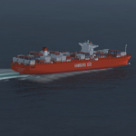
This package contains replacement effects to be used with my packages "63 AI Ships and AI Ship Traffic for Europe and South America", "75 AI Ships and AI Ship Traffic" and "Patch for 75 AI Ships and AI Ship Traffic".
The new wake files resolve the problem descried by some as "heavenly" wakes. Some obscure difference makes ship wakes including certain parameters turn towards the heaven in P3D while they work as intended in FSX.
In order to get full benefit of this package you must first download and install "63 AI Ships and AI Ship Traffic for Europe and South America" and "75 AI Ships and AI Ship Traffic" and "Patch for 75 AI Ships and AI Ship Traffic" in the mentioned order.
These replacement files are only for P3D.
| Filename: | P3D_replacement_effects_for_AI_ships_and_AI_Ship_T.zip |
| License: | Freeware |
| Added: | 7th September 2013, 22:46:16 |
| Downloads: | 5,466 |
| Author: | Henrik Nielsen |
| Size: | 74.93 KB |
| Category: Flight Simulator X - AFCAD Files | |
| KSVC Grant County Airport - Silver City, New Mexico |
|
File Description:
This scenery updates KSVC Grant County airport located near Silver City, New Mexico. The apron was enlarged, cargo and small airline parking spots were added, apron access taxiways were added, a terminal building, two hangars, water tank, and fire watch tower were added, the airport access road was added, and the approach VASI lights were changed to PAPI lights. An optional landclass file is also included to depict the mining operation to the east of the airport. The scenery was designed with ORBX FTX Global Vector and Pilot's Global Ultimate terrain mesh installed, but it should work OK with the default vector scenery and mesh. This scenery was created using the awesome scenery tool Airport Design Editor by Scruffyduck Software. Please refer to the readme file for more details and installation instructions.
| Filename: | KSVC_Grant_County_Airport__Silver_City_New_Mexico.zip |
| License: | Freeware |
| Added: | 4th February 2017, 18:05:29 |
| Downloads: | 337 |
| Author: | David Midgett |
| Size: | 2.74 MB |
| Category: Flight Simulator X - Scenery | |
| MSLP - El Salvador International Airport - San Salvador, El Salvador |
|
File Description:
El Salvador International Airport (IATA: SAL, ICAO: MSLP) is a joint use Militrary and Public airport located approximately 50 km from San Salavador. It is the third busiest airport in Central America. The scenery includes relocated taxiways, new and enlarged aprons, rebuilt terminals and air-bridges, and other buildings.
This scenery was designed to be used with the default FSX scenery.
| Filename: | MSLP__El_Salvador_International_Airport__San_Salva.zip |
| License: | Freeware |
| Added: | 21st March 2016, 09:46:53 |
| Downloads: | 1,492 |
| Author: | Bill Bridges |
| Size: | 16.25 KB |
| Category: Flight Simulator X - Scenery | |
| Crete Island, Version 2 |
|
Images related to this file:
File Description:
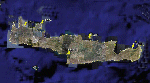
Crete is the bigger than the islands of the Greek archipelago and it is the south rampant of the Aegean sea. This scenery contains the following airports: LGIR, LGSA, LGOB, LGTL and 78 cities.
In this 2nd version I have used the mesh terrain of Yiannis Dermitzakis that offers a bigger realism to the costs. This has put under an obligation to reconstruct the entirety of the populations of the since costs they were located inside the sea. At the same time I have been able to redraw them populations with houses and real facilities that. I believe that I can offer a quite realistic scenery especially in the group of populations of the coast.
| Filename: | Crete_Island_Version_2.zip |
| License: | Freeware |
| Added: | 7th November 2009, 21:08:05 |
| Downloads: | 6,013 |
| Author: | Toni Agramont |
| Size: | 31.14 MB |
| Category: Flight Simulator X - Scenery | |
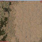
| Detailed Terrain Features for Southern Africa, Update 4 |
|
Images related to this file:
File Description:

Scenery consists of Updated Terrain Vector data concerning Coastlines, rivers, dams, streams, roads, traffic, railroads, power lines and extrusion bridges for Southern Africa countries South of the Equator. The Zambezi River and Areas around Arnot, Ermelo (South Africa) was updated by utilizing Satellite image backgrounds. This scenery is important and will be needed with release of future scenery by Aeroworx. Please install the previous release fsxWorx01.zip and updates before this file.
| Filename: | Detailed_Terrain_Features_for_Southern_Africa_Upda.zip |
| License: | Freeware |
| Added: | 27th January 2013, 18:39:21 |
| Downloads: | 3,799 |
| Author: | Hannes Steyn, Aeroworx |
| Size: | 9.84 MB |
| Category: Flight Simulator X - Miscellaneous Files | |
| Morocco Vectors VFR |
|
Images related to this file:
File Description:
This project add and update vectors for Morocco and Western Sahara. Accurate coastline, lakes, roads, railways and river/streams. This vectors are optimized with Terrain Mesh SRTM 1 arc sec (LOD11). Scenery for FSX//P3Dv1/2/3/4.
| Filename: | Morocco_Vectors_VFR.zip |
| License: | Freeware |
| Added: | 9th June 2017, 21:04:48 |
| Downloads: | 771 |
| Author: | Giovanni Miduri |
| Size: | 20.49 MB |
| Category: Flight Simulator X - Scenery | |
| Mesh Correction |
|
File Description:
These files correct wrong shape of FSX mesh at Lagoa Santa and Governador Valadares, Minas Gerais, Brazil, fixing the elevation to the real height level.
| Filename: | Mesh_Correction.zip |
| License: | Freeware, limited distribution |
| Added: | 16th March 2007, 01:55:24 |
| Downloads: | 942 |
| Author: | Cesar Marinho |
| Size: | 134.9 KB |
| Category: Flight Simulator X - Scenery | |
| Açores Mesh |
|
File Description:
Açores Island Mesh, basead on SRTM elevation files, This mesh cover entire Açores Island, Portugal. Works on FS2002, 2004 and FSX.
Freeware by Cesar Marinho.
| Filename: | Aores_Mesh.zip |
| License: | Freeware |
| Added: | 22nd April 2007, 04:50:37 |
| Downloads: | 5,532 |
| Author: | Cesar Marinho |
| Size: | 567.5 KB |
© 2001-2026 AVSIM Online
All Rights Reserved
Privacy Policy |