
Where Flight Simulation Enthusiasts Gather from Around the World!
AVSIM Library - Search Results

| Category: Flight Simulator X - Scenery | |
| LOXA Aigen im Ennstal Update for Austria Professional HD East |

|
File Description:
This is an update for my LOXA scenery for Austrian Professional HD users.
Because the mesh in the Austria Professional HD unfortunately does not fit the altitudes of the most austrian airports correctly, there usually accure some problems with a lot of scenery-addons. The transition from the airports altitudes to the Austrian Professional mesh in most cases is a hard "altitude-break" and doesn't look very "professional".
This update fits this problem in my LOXA scenery.
The LOXA airport altitude is not touched. LOXA has still the in the charts assigned correct altitude. Only the blend into the Austria Pro mesh is made a lot smoother.
This update requires my LOXA_Ver.10 scenery
| Filename: | LOXA_Aigen_im_Ennstal_Update_for_Austria_Professio.zip |
| License: | Freeware |
| Added: | 19th January 2017, 07:23:59 |
| Downloads: | 561 |
| Author: | Wolfgang Allers |
| Size: | 5.42 KB |
| Category: Flight Simulator X - Scenery | |
| Smithers, CYYD |
|
File Description:
Contained is an approximation of CYYD, Smithers Regional Airport, BC, made using the fsx object placement tool. Just pop it in your fsx\add on scenery\scenery folder. This scenery works well with Combat Planes Northern Adventures sampler. Notice that any xml mission file can be converted to a permanent bgl file for personal use with the bgl compiler of the SDK or Abacus Scenery Shortcut. For example, the Combat Planes Terrace Airport, CYXT. Thus, with this file and the above mentioned, one can have a nice circuit to fly from Smithers through Terrace down to Sandspit and back up to the Sitkine Area, to be improved in the future no doubt with Tongass Fjords II. FSG North America terrain mesh highly recommended.
| Filename: | Smithers_CYYD.zip |
| License: | Freeware |
| Added: | 17th February 2007, 15:36:47 |
| Downloads: | 1,451 |
| Author: | Joe Solomon |
| Size: | 26.78 KB |
| Category: Flight Simulator X - Scenery | |
| EGNH Blackpool |
|
File Description:
EGNH Blackpool for FSX. Blended to fit Horizon Photo Scenery and Mesh.
Scenery items from various authors associated with the Runway 12 project have been used to enhance the scenery. Details of the extra files required are included in the readme.
| Filename: | EGNH_Blackpool.zip |
| License: | Freeware, limited distribution |
| Added: | 5th December 2007, 17:59:35 |
| Downloads: | 2,637 |
| Author: | Tony Meredith |
| Size: | 1.12 MB |
| Category: Flight Simulator X - Scenery | |
| EGNC Carlisle |
|
File Description:
EGNC Carlisle for FSX. Blended to fit Horizon Photo Scenery and Mesh.
Scenery items from various authors associated with the Runway 12 project have been used to enhance the scenery. Details of the extra files required are included in the readme.
| Filename: | EGNC_Carlisle.zip |
| License: | Freeware, limited distribution |
| Added: | 5th December 2007, 18:01:40 |
| Downloads: | 1,450 |
| Author: | Tony Meredith |
| Size: | 759.73 KB |
| Category: Flight Simulator X - Scenery | |
| Faroe Island |
|
Images related to this file:
File Description:
Version four of Faroe Island scenery with many updates, mesh corrections, new gmax buildings and ungoing work for the extended runway on Vagar airport
| Filename: | Faroe_Island.zip |
| License: | Freeware |
| Added: | 26th February 2011, 00:41:57 |
| Downloads: | 2,393 |
| Author: | Ryan Andersen and Peter H. Poulsen |
| Size: | 70.95 MB |
| Category: Flight Simulator X - Scenery | |
| EGDC - RAF Chivenor |
|
File Description:
RAF Chivenor for FSX. File blended to Horizon GenX Scenery and Mesh to remove cliff effect Scenery is default and items from Runway12 Libraries.
Open the hangar doors to find what is located inside.
| Filename: | EGDC__RAF_Chivenor.zip |
| License: | Freeware, limited distribution |
| Added: | 9th October 2007, 19:47:31 |
| Downloads: | 1,851 |
| Author: | Tony Meredith |
| Size: | 630.24 KB |
| Category: Flight Simulator X - Scenery | |
| Northeast New Jersey 5 Meter Mesh Terrain |
|
Images related to this file:
File Description:
High Resolution Northeast New Jersey 5 Meter Mesh Terrain by Wally-Bob represents a significant improvement over FSX default 38 meter mesh terrain. The results are also dramatic compared to 10 meter compressed payware mesh as lossless compression compilation (read no data loss) is used. Lossless compiling produces renderings that have the Crispness of the Real World Terrain. Fly the Hudson River and view the Palisades as they are in real life, see the screen shots enclosed. High Quality 5 meter mesh terrain is a must have for mountainous areas especially where photo scenery is also used to render the virtual world. Manual includes FSX configuration and scenery installation tips. USGS LiDAR 1/9 Arc-Second source data.
| Filename: | Northeast_New_Jersey_5_Meter_Mesh_Terrain.zip |
| License: | Freeware, limited distribution |
| Added: | 26th February 2011, 21:35:52 |
| Downloads: | 1,100 |
| Author: | Walter Roberts |
| Size: | 135.89 MB |
| Category: Flight Simulator X - Scenery | |
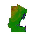
| Mesh for Southern Africa, Base Grid 0605 |
|
Images related to this file:
File Description:

Highly detailed 76m SRTM mesh for Africa using the latest release of STRM Data V2.1. This file covers the Africa Area of base file 0605 (S23 and E00), South of the Equator. DO NOT DISABLE THE DEFAULT DEM 605 FILE.
| Filename: | Mesh_for_Southern_Africa_Base_Grid_0605.zip |
| License: | Freeware |
| Added: | 13th January 2014, 13:37:08 |
| Downloads: | 2,995 |
| Author: | Martin du Preez, Hannes Steyn, Aeroworx |
| Size: | 152.7 MB |
| Category: Flight Simulator X - Scenery | |
| Mesh for Southern Africa, Base Grid 0604 |
|
Images related to this file:
File Description:
Highly detailed 76m SRTM mesh for Africa using the latest release of STRM Data V2.1. This file covers the Africa Area of base file 0604 (S01 and E00), South of the Equator. DO NOT DISABLE THE DEFAULT DEM 0604 FILE.
| Filename: | Mesh_for_Southern_Africa_Base_Grid_0604.zip |
| License: | Freeware |
| Added: | 31st January 2014, 15:21:39 |
| Downloads: | 2,929 |
| Author: | Martin du Preez, Hannes Steyn, Aeroworx |
| Size: | 397.23 MB |
| Category: Flight Simulator X - AI Flight Plans | |
| Air Transat Winter 2022 Flight Plans |
|
Images related to this file:
File Description:
![]()
Winter 2022 Flightplans for Air Transat, operating 17 Airbus A321's and 6 A330's during the winter. Features 310 weekly flights to 35 destinations across North/South America, The Caribbean and Europe. Schedule taken from March 13th to March 20th, 2022.
| Filename: | Air_Transat_Winter_2022_Flight_Plans.zip |
| License: | Freeware |
| Added: | 24th March 2022, 03:06:24 |
| Downloads: | 334 |
| Author: | Ryan O'Reilly |
| Size: | 4.79 KB |
© 2001-2026 AVSIM Online
All Rights Reserved
Privacy Policy |