
Where Flight Simulation Enthusiasts Gather from Around the World!
AVSIM Library - Search Results

| Category: Flight Simulator X - AFCAD Files | |
| KLEX - Blue Grass Airport - Lexington, Kentucky |

|
Images related to this file:
File Description:
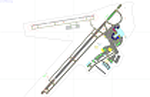
This airport update was made with the latest version of ADE (Airport Design Editor) and made for FSX as a replacement for the stock (default) airport. I've made several changes to the airport which are listed below. All these enchancements are as close to the real airport as I can get with stock library objects. I've used satellite images, terminal photos and maps throughout the whole process so building locations are as accurate as possible. Happy landings in charming Kentucky!
Features:
*Expanded parking apron
*Taxiways properly desginated
*Runway 8/26 renamed to 9/27 and moved to correct location as FSX had it completely wrong, appropriate taxiways have been repositioned and/or removed as well as per latest airport diagram
*Completely redesigned main terminal building with accurate airline assigned gates
*Seperate parking areaa for GA traffic
*Misc airport buildings added
*Airport vehicles and objects throughout the airport
*Fuel tanks and vehicles
*Fire station and vehicles
*De-icing trucks
*Static aircraft
*Autogen removed from a few areas around the airport as several buildings were popping up on airport property and a few trees were too close to runway
| Filename: | KLEX__Blue_Grass_Airport__Lexington_Kentucky.zip |
| License: | Freeware |
| Added: | 22nd December 2012, 00:03:01 |
| Downloads: | 598 |
| Author: | Jaison Diaz / Endeavour ai |
| Size: | 153.05 KB |
| Category: Flight Simulator X - AFCAD Files | |
| MHLC - Goloson International Airport - La Ceiba, Honduras |
|
Images related to this file:
File Description:
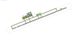
Goloson International Airport (Spanish: Aeropuerto Internacional Goloson) (IATA: LCE, ICAO: MHLC) is an airport located on the western side of the city of La Ceiba, in the Atlantida Department on the north coast of Honduras. It is also known as La Ceiba Airport (Aeropuerto de La Ceiba) and Hector C. Moncada Air Base (Base Aerea Hector C. Moncada). The Airport serves as the headquarters for Aerolineas Sosa.
Features:
*Expanded parking apron
*Taxiways properly designated and aligned
*Runway markings and lighting corrected
*Parking spots for commercial traffic
*Separate parking area for GA traffic
*Misc airport buildings added
*Airport vehicles and objects throughout the airport
*Fuel service vehicles
*Static aircraft
| Filename: | MHLC__Goloson_International_Airport__La_Ceiba_Hond.zip |
| License: | Freeware |
| Added: | 5th February 2014, 23:07:36 |
| Downloads: | 443 |
| Author: | Jaison Diaz / Endeavour AI |
| Size: | 79.61 KB |
| Category: Flight Simulator X - Scenery | |
| Greater Kankakee KIKK |
|
Images related to this file:
File Description:
FSX Scenery - Greater Kankakee Airport (IATA: IKK, ICAO: KIKK, FAA LID: IKK) is a public airport located three miles (5 km) south of the central business district of Kankakee, in Kankakee County, Illinois, United States. The airport was opened in 1962 and continues to operate as a general aviation facility serving the Kankakee area and South Chicago. It is 60 miles (97 km) south of Chicago and 75 miles (121 km) north of Champaign, Illinois. It is the largest Airport between the Chicago Midway Airport and the Champaign Airport. Greater Kankakee is a general aviation airport, consisting of mostly private aircraft with a mix of corporate and business aircraft usage. Created by John B Loney Jr.
| Filename: | Greater_Kankakee_KIKK.zip |
| License: | Freeware, limited distribution |
| Added: | 20th March 2012, 01:36:22 |
| Downloads: | 646 |
| Author: | John B. Loney, Jr. |
| Size: | 4.09 MB |
| Category: Flight Simulator X - Scenery | |
| Yuba Co-Oroville Muni |
|
File Description:
FSX Scenery - Yuba County Airport (IATA: MYV, ICAO: KMYV) is a public airport located three miles (4.8 km) southeast of Marysville, serving Yuba County, California, USA. The airport has two runways and is mostly used for general aviation. Oroville Municipal Airport (IATA: OVE, ICAO: KOVE) is a public airport located 3 miles (5 km) southwest of the city of Oroville in Butte County, California, USA. Oroville Municipal Airport covers 920 acres and has two runways. This airport is about 23nm NW of Yuba Co. An 18 hole golf course is located right next to the facility for you "Fly-in Golfers". EZ Scenry libraries require, some are included. By John B. Loney, Jr. and Robert Lacy.
| Filename: | Yuba_CoOroville_Muni.zip |
| License: | Freeware, limited distribution |
| Added: | 11th May 2010, 21:36:46 |
| Downloads: | 1,305 |
| Author: | John B. Loney, Jr. |
| Size: | 9.77 MB |
| Category: Flight Simulator X - AFCAD Files | |
| Al Massira International Airport, Agadir, Morocco |
|
File Description:
A more realistic AFCAD File for Al Massira International Airport, Agadir, Morocco than the default Airport in FSX. The airport served 1.5 million passengers in 2007, mostly tourists from Europe seeking the sun and the Atlantic ocean sandy beaches
| Filename: | Al_Massira_International_Airport_Agadir_Morocco.zip |
| License: | Freeware |
| Added: | 30th April 2009, 16:47:07 |
| Downloads: | 931 |
| Author: | Bashir Ismail |
| Size: | 86.61 KB |
| Category: Flight Simulator X - Scenery | |
| Grati Pacitan Airport (WARD) |
|
Images related to this file:
File Description:
Grati Airport (WARD), formally known as R.E.B.O Tjokroadiredjo Airport is an Indonesian Navy Base Located in Pasuruan District, East Java, 34 miles South East of Surabaya. Grati was opened in October 10 2016. This airport serves VFR flight only.
| Filename: | Grati_Pacitan_Airport_WARD.zip |
| License: | Freeware |
| Added: | 20th March 2021, 16:26:51 |
| Downloads: | 55 |
| Author: | Sangwang Amarapati |
| Size: | 587.27 KB |
| Category: Flight Simulator X - AFCAD Files | |
| EGDG_afcad.zip |
|
File Description:
FSX afcad for UK airport EGDG St Mawgan (aka Newquay Airport). Based on the default layout and providing parking spaces some with the codes of the airlines which now use the airport. Read EGDGinformation.txt (within zip) for more details.
| Filename: | EGDG_afcadzip.zip |
| License: | Freeware |
| Added: | 1st October 2007, 21:32:25 |
| Downloads: | 721 |
| Author: | Colin Dietrich |
| Size: | 11.23 KB |
| Category: Flight Simulator X - Scenery | |
| KPNE Northeast Philadelphia Airport |
|
Images related to this file:
File Description:

KPNE Northeast Philadelphia Airport. Detailed general aviation airport with all new hand placed buildings using Google earth. Some buildings were left out to keep this highly detailed airport frame rate friendly. This scenery works well with general aviation AI.
| Filename: | KPNE_Northeast_Philadelphia_Airport.zip |
| License: | Freeware |
| Added: | 30th November 2010, 06:20:58 |
| Downloads: | 919 |
| Author: | Rob Touchtone |
| Size: | 199.36 KB |
| Category: Flight Simulator X - Scenery | |
| EDUT Templin Groß Dölln |
|
File Description:
The Airport "Templin" first were used by the German "Luftwaffe". After the WW2 the Russian Airforce become home there. This Airport was the biggest Airport in the GDR. I have resized the Runway to orginal 3500 x 60 meters.
| Filename: | EDUT_Templin_Gro_Dlln.zip |
| License: | Freeware |
| Added: | 17th April 2009, 09:38:39 |
| Downloads: | 480 |
| Author: | Guido Weiß |
| Size: | 285.93 KB |
| Category: Flight Simulator X - AFCAD Files | |
| Columbia Metropolitan Airport, Columbia, South Carolina (KCAE) |
|
File Description:
AFCAD file made with Airport Design Editor to adjust the airport taxiways, aprons, aircraft parking, fences and buildings on the east side of Metro Airport in Columbia, SC to clear roads and vehicular traffic added by Ultimate Terrain USA.
| Filename: | Columbia_Metropolitan_Airport_Columbia_South_Carol.zip |
| License: | Freeware |
| Added: | 18th May 2008, 21:51:46 |
| Downloads: | 889 |
| Author: | Art Poole |
| Size: | 13.84 KB |
© 2001-2026 AVSIM Online
All Rights Reserved
Privacy Policy |