
Where Flight Simulation Enthusiasts Gather from Around the World!
AVSIM Library - Search Results

| Category: Flight Simulator X - Aircraft Repaints, Textures and Modifications | |
| Douglas C-47 (G-AMCA) Air Atlantique |

|
Images related to this file:
File Description:
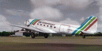
This folder contains a repaint for version 3.14 of the Douglas C-47 by Manfred Jahn and colleagues in the colors of G-AMCA (c/n 16218, ex-44-76634, KN487), one of the C-47's operated by Air Atlantique, which was an airline based at Coventry Airport operating a number of classic aircraft, both for passenger operation and for cargo operation. At present, it is being used at the old Valkenburg airbase in the Netherlands as scenery for the musical 'Soldier of Orange'.Repaint by Jan Kees Blom for Manfred Jahn's C-47 version 3.14, based on the paintkit by Gman5250.
| Filename: | Douglas_C47_GAMCA_Air_Atlantique.zip |
| License: | Freeware |
| Added: | 14th August 2018, 21:29:17 |
| Downloads: | 349 |
| Author: | Jan Kees Blom |
| Size: | 11.64 MB |
| Category: Flight Simulator X - Aircraft Repaints, Textures and Modifications | |
| Transglobe Airways Bristol Britannia 314 1965 |
|
Images related to this file:
File Description:
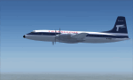
This is a repaint of the Bristol 175 Britannia 314 in Transglobe Airways colors. You need the freeware Bristol Britannia by Jens B Kristensen (FSX). On August 1, 1965, Air Links, Ltd. was officially renamed Transglobe Airways, Ltd. , and simultaneously a new Bristol Britannia 314 started flying a number of inclusive tours from London Gatwick Airport on behalf of British United Airways, Ltd. A second Britannia was delivered on December 12. All up, Transglobe operated 4 Britannias. Textures are 32bit dds. This aircraft was tested on FSX-SE. It should work on FSX & P3D v1-3
| Filename: | Transglobe_Airways_Bristol_Britannia_314_1965.zip |
| License: | Freeware |
| Added: | 24th January 2019, 05:07:46 |
| Downloads: | 51 |
| Author: | Ted Giana |
| Size: | 3.44 MB |
| Category: Flight Simulator X - Scenery Design | |
| FS2004/FSX Scenery Design Do-it-Yourself Hangar Building Kit |
|
Images related to this file:
File Description:
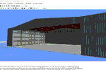
FS2004/FSX Scenery Design Do-it-Yourself Hangar Building Kit
Remember when we went down to the local hobby shop, drug store, or the like and bought
that first model airplane to put together? I wanted to see if I could help recreate a
little of that excitement and motivate some of us to try scenery building. So here are
step-by-step instructions on making a KLEX Lexington Bluegrass airport hangar in both
closed and open-with-interior versions. Textures are included, as are finished versions
for the easily frustrated. Assembly required!! Have fun!
by Dan French
| Filename: | FS2004FSX_Scenery_Design__DoitYourself_Hangar_Buil.zip |
| License: | Freeware |
| Added: | 3rd December 2021, 22:27:57 |
| Downloads: | 144 |
| Author: | Dan French |
| Size: | 35.29 MB |
| Category: Flight Simulator X - Scenery | |
| The Real VCBI X |
|
Images related to this file:
File Description:

This is the complete & high detailed scenery of Bandaranaike International Airport
for Microsoft Flight Simulator X. If you are a Sri Lankan flightsimmer or like to fly
around Sri Lanka in Flight Simulator X, then this is a must for you!.
Features -: High quality Satellite terrain.
G-Max�������® designed terminal and other buildings.
Accurate building and apron placement.
Extremely high detailed terminal and surroundings.
Re-Adjusted glide scope and localizer to match actual situation.
Road traffic animations and other effects.
High detailed Autogen data.
| Filename: | The_Real_VCBI__X.zip |
| License: | Freeware, limited distribution |
| Added: | 4th October 2011, 08:00:05 |
| Downloads: | 8,634 |
| Author: | Gayan Liyanaarachchi |
| Size: | 22.65 MB |
| Category: Flight Simulator X - Aircraft Repaints, Textures and Modifications | |
| Asiana Airlines B777-200ER (PW) (HL7500) **UPDATE ** |
|
Images related to this file:
File Description:

REPAINT UPDATED FOR - new Captain Sim v1.0 folders, improved wear pattern on wings, correction to engine paint issues, converted to Pratt & Whitney engines.
This is a repaint of a Boeing 777-200ER, registration code HL7500, operated by Asiana Airlines, operated by Asiana Airlines, one of South Korea's two major airlines, along with Korean Air. Asiana has its headquarters in Asiana Town in Osoe-dong, Gangseo-gu, Seoul. The airline has its domestic hub at Gimpo International Airport and its international hub at Incheon International Airport. Asiana is a member of the Star Alliance and offers 516 daily departures throughout Asia, Europe, North America, and Oceania, operating 14 domestic and 85 international passenger routes and 20 cargo routes. Asiana currently operates eleven Boeing 777-200ER aircraft.
This repaint has plenty of clear markings so if you enjoy exterior detail, then you will love this repaint. You can see (and read): Door opening instructions; Static port directions; Air vent warnings; Engine hazard area; No Step warnings; RAT caution; APU intake warning; Stabilizer compartment access; Ground power supply; Forward and aft access door instructions; Pitot, ADA probe, Ice detector and TAT probe markings; Visible rivets; Enhanced window frames; Authentic Asiana logo; Bold, colorful Asiana livery and authentic flags; Lovely Asiana flight attendant; No frame rate hit.
To use this repaint, the Captain Sim B777-200 v1.0 is required. Repainted by Garrett Rowley, [email protected]
| Filename: | Asiana_Airlines_B777200ER_PW___HL7500__UPDATE_.zip |
| License: | Freeware |
| Added: | 27th February 2013, 14:36:54 |
| Downloads: | 4,174 |
| Author: | Garrett Rowley, Captain Sim |
| Size: | 30.12 MB |
| Category: Flight Simulator X - Aircraft Repaints, Textures and Modifications | |
| Air India Boeing 777-200LR GE (VT-ALC) |
|
Images related to this file:
File Description:

This is a repaint of a Boeing 777-200LR, registration code VT-ALC, operated by Air India, the flag carrier airline of India, serving Asia, the United States, and Europe from two major domestic hubs at Indira Gandhi International Airport and Chhatrapati Shivaji International Airport. The airline's logo, featured prominently on the tail of the aircraft, is a red Flying Swan with the orange Konark Chakra placed inside it. The colors signify vigour and advancement. Running parallel to each other is the Orange and Red speed lines from front door to the rear door. The brand name "Air India" runs across the tail of the aircraft in Hindi. Air India currently operates 8 B777-200LRs and 12 B777-300ERs.
This repaint has plenty of clear markings so if you enjoy exterior detail, then you will love this repaint. You can see (and read): Door opening instructions; Static port directions; Air vent warnings; Engine hazard area; No Step warnings; RAT caution; APU intake warning; Stabilizer compartment access; Ground power supply; Forward and aft access door instructions; Pitot, ADA probe, Ice detector and TAT probe markings; Visible rivets; Enhanced window frames; Authentic Air India logo; Bold, colorful Air India livery and authentic flags; Lovely Air India flight attendant; No frame rate hit.
To use this repaint, the Captain Sim B777-200 v1.0 is required. Repainted by Garrett Rowley.
| Filename: | Air_India_Boeing_777200LR_GE_VTALC.zip |
| License: | Freeware |
| Added: | 7th March 2014, 12:37:23 |
| Downloads: | 1,163 |
| Author: | Garrett Rowley, Captain Sim |
| Size: | 26.38 MB |
| Category: Flight Simulator X - Aircraft Repaints, Textures and Modifications | |
| Air India Boeing 777-300ER GE (VT-ALM) |
|
Images related to this file:
File Description:

This is a repaint of a Boeing 777-300ER, registration code VT-ALM, operated by Air India, the flag carrier airline of India, serving Asia, the United States, and Europe from two major domestic hubs at Indira Gandhi International Airport and Chhatrapati Shivaji International Airport. The airline's logo, featured prominently on the tail of the aircraft, is a red Flying Swan with the orange Konark Chakra placed inside it. The colors signify vigour and advancement. Running parallel to each other is the Orange and Red speed lines from front door to the rear door. The brand name "Air India" runs across the tail of the aircraft in Hindi. Air India currently operates 8 B777-200LRs and 12 B777-300ERs.
This repaint has plenty of clear markings so if you enjoy exterior detail, then you will love this repaint. You can see (and read): Door opening instructions; Static port directions; Air vent warnings; Engine hazard area; No Step warnings; RAT caution; APU intake warning; Stabilizer compartment access; Ground power supply; Forward and aft access door instructions; Pitot, ADA probe, Ice detector and TAT probe markings; Visible rivets; Enhanced window frames; Authentic Air India logo; Bold, colorful Air India livery and authentic flags; Lovely Air India flight attendant; No frame rate hit.
To use this repaint, the Captain Sim B777-300 v1.3 is required. Repainted by Garrett Rowley.
| Filename: | Air_India_Boeing_777300ER_GE_VTALM.zip |
| License: | Freeware |
| Added: | 5th April 2014, 21:39:52 |
| Downloads: | 912 |
| Author: | Garrett Rowley, Captain Sim |
| Size: | 31.04 MB |
| Category: Flight Simulator X - Scenery | |
| USCG Air Station Sitka PASI Scenery Package with AI Aircraft |
|
Images related to this file:
File Description:

Thanks to Airport Design Editor(ADE), Military AI Works (MAIW) scenery and aircraft, along with AI Flight Planner3 (AIFP3), I did my best to re-create USCG Air Station Sitka for FSX. Creating this airport scenery (along with Kodiak PADQ) was my first attempt at a BIG (for me) scenery project in ADE, but thanks to MAIW and their Global Scenery Library Objects, I think I've succeeded in re-creating the airbase. You'll need to go to MAIW's website and download that "Global Scenery" file for any of this to work, so I've copied that website link below (in STEP 1). I also added Sitka markings to all the AI helicopters for added realism.
And just for fun, I placed a USCG Cutter and a "fishing boat in distress" (complete with green smoke) out in the harbor as a "Practice Rescue Scenario". The Cutter has a "hard deck" to land on and I've also illuminated both it and the Fishing boat for DUSK and NIGHT practice.
*SPECIAL NOTE* THE AI C-130 in the pictures is from my Kodiak scenery package, there are only Helicopters based at Sitka...but I have it "fly in" from my Kodiak scenery package. So if you're interested in that, you can find the "USGC Air Station Kodiak AK PADQ Scenery Package with AI Aircraft" on AVSIM as well.
| Filename: | USCG_Air_Station_Sitka_PASI_Scenery_Package_with_A.zip |
| License: | Freeware |
| Added: | 31st January 2021, 06:43:13 |
| Downloads: | 1,102 |
| Author: | Daniel W Gregory |
| Size: | 16.58 MB |
| Category: Flight Simulator X - Scenery | |
| Red Bull Air Race Course Monument Valley Ver 0.5 |
|
File Description:
This will add the Red Bull Air Race Course in Monument Valley, Utah, scheduled for 12 May 07. I have added the pylons for the race course, a control tower and a few tents and concession stands. I plan to later add more details such as some roads near the course, more buildings and some details for Oljato Airport. All these objects are default and come with FSX, thus you are not installing any new models or anything, so you need not be worried about a low frame rate.
Ver 0.5
Highly recommend 38M mesh for Utah. Free one here --->http://library.avsim.net/esearch.php?CatID=fs2004scen&DLID=46310
| Filename: | Red_Bull_Air_Race_Course_Monument_Valley_Ver_05.zip |
| License: | Freeware |
| Added: | 4th May 2007, 04:20:25 |
| Downloads: | 1,333 |
| Author: | Nick Mathews |
| Size: | 222.88 KB |
| Category: Flight Simulator X - Original Aircraft | |
| Southern Cross Fokker FVII/3m. |
|
File Description:
FSX / FS2004 Southern Cross Fokker FVII/3m.
The 'Southern Cross' made the first crossing of the Pacific Ocean by an aircraft, flown by Charles Kingsford-Smith and a crew of three. They took off from Oakland, California on May 31, 1928, and arrived at Brisbane, Australia on June 19. The Southern Cross was, at the time, even more famous than Charles Lindberg's 'Spirit of St. Louis'. The Southern Cross is preserved today at Brisbane Airport. This package includes the aircraft model and ready-made flights you can use to recreate the 1928 experience. Improved version 2 model, modified to work with FSX as well as FS2004. By Jens B. Kristensen
| Filename: | Southern_Cross_Fokker_FVII3m.zip |
| License: | Freeware |
| Added: | 24th June 2007, 13:52:16 |
| Downloads: | 2,053 |
| Author: | Jens B. Kristensen |
| Size: | 12.09 MB |


© 2001-2026 AVSIM Online
All Rights Reserved
Privacy Policy |