
Where Flight Simulation Enthusiasts Gather from Around the World!
AVSIM Library - Search Results

| Category: Flight Simulator X - Scenery | |
| LSZH (Zurich-Airport) Region Cities and Villages Landclass |

|
File Description:
This is an update to the FSX Region around LSZH (Zurich-Switzerland). Many cities and villages missing in the approach-path to RWY14 and RWY16. This Version adds city of Bülach, villages like Stadel, Weiach, Hohentengen etc.
| Filename: | LSZH_ZurichAirport_Region_Cities_and_Villages_Land.zip |
| License: | Freeware |
| Added: | 27th January 2007, 15:40:39 |
| Downloads: | 11,707 |
| Author: | Mike Gamp (AirMike) |
| Size: | 13.89 MB |
| Category: Flight Simulator X - Scenery | |
| KJAX - Jacksonville International Airport - Florida, USA (New Runways) |
|
File Description:
This is an update to my scenery for Jacksonville Intl. Airport from September of 2010. The runway numbers needed to be changed in late 2011 due to a shift in the earth's magnetic field. Runway 7/25 is now Runway 8/26 and Runway 13/31 is now Runway 14/32. The new runway numbers, along with new taxiway signs to reflect the new designators, plus new approaches for the new runways are included in the .bgl files contained here. Requires a previous installation of the original airport (aig_kjax_jacksonville_florida_fsx_default.zip).
| Filename: | KJAX__Jacksonville_International_Airport__Florida_.zip |
| License: | Freeware, limited distribution |
| Added: | 23rd February 2016, 22:10:31 |
| Downloads: | 889 |
| Author: | Patrick Finch |
| Size: | 91.12 KB |
| Category: Flight Simulator X - Scenery | |
| KPVG - Hampton Roads Executive Airport - Virginia, USA **Update** |
|
Images related to this file:
File Description:
FSX Scenery - This is an update for my FSX version of Hampton Roads Executive Airport scenery, KPVG. (hampton-roads_kpvg_fsx_2014.zip) In September 2014, Hampton Roads unveiled their new runway 10/28 replacing the old 10/28. The new runway is 5350 ft. in length and 100 ft. wide. For your Flight Sim flying pleasure by John B. Loney, Jr.
| Filename: | KPVG__Hampton_Roads_Executive_Airport__Virginia_US.zip |
| License: | Freeware, limited distribution |
| Added: | 30th December 2014, 01:23:14 |
| Downloads: | 531 |
| Author: | John B. Loney, Jr. |
| Size: | 282.05 KB |
| Category: Flight Simulator X - Scenery | |
| LFFD - Saint-Andre-de-l'Eure Airport - Normandy, France |
|
File Description:
A forgotten airfield in FSX, near Evreux in Normandy(France). Activity: Microlight (ULM) and light aviation
Realized with the software ADE.
Tested with UTX Europe + Gex + TrueLandscape on a mesh of 38 m.FPS friendly.
| Filename: | LFFD__SaintAndredelEure_Airport__Normandy_France.zip |
| License: | Freeware, limited distribution |
| Added: | 11th August 2013, 16:48:16 |
| Downloads: | 874 |
| Author: | Christian Davi |
| Size: | 4.23 MB |
| Category: Flight Simulator X - Scenery | |
| KTEB Teterboro Airport, New Jersey - *Update* New Taxiways |
|
File Description:
This is an update to 'teterboro_airport.zip' by Eric McCloud (found here on AVSIM). It adds new taxiways to bring the airport up to date with the most recently published airport diagrams. Also some slight taxiway sign tweakage, closed a taxiway that is no longer operational, some additional apron lighting and a few cosmetic hold-short lines - these were added as they appear on Google Maps satellite imagery but are not connected to the AI link system so they will not affect AI traffic flow.
| Filename: | KTEB_Teterboro_Airport_New_Jersey__Update_New_Taxi.zip |
| License: | Freeware |
| Added: | 8th September 2010, 10:40:27 |
| Downloads: | 982 |
| Author: | Drew Sikora |
| Size: | 32.13 KB |
| Category: Flight Simulator X - AFCAD Files | |
| VOPB - Veer Savarkar Intl. Airport - Port Blair, India |
|
Images related to this file:
File Description:

AFCAD file (V2.0) for Veer Savarkar International Airport, Port Blair, India (VOPB) for FSX. This file gives the near realistic layout of the taxiways with taxiway signs, and parking stands/gates. This contribution is part of "Project FSX India" initiative 2013-2015. Remark: Major Fixes and Updates.
| Filename: | VOPB__Veer_Savarkar_Intl_Airport__Port_Blair_India.zip |
| License: | Freeware |
| Added: | 2nd March 2015, 20:44:16 |
| Downloads: | 566 |
| Author: | Arjun Bala |
| Size: | 8.07 KB |
| Category: Flight Simulator X - Scenery | |
| Archipelago of St-pierre & Miquelon (non-flat airport) |
|
File Description:
"The archipelago of St Pierre (LFVP) and Miquelon (LFVM)".
Theses islands are situated in the south of New Foundland island, beetwin Canada and United States.
All the archipelago is made up of a new local mesh, landclass, photorealists textures in 2m/pixel in St-Pierre island (4 seasons and the night) with specific autogen, the harbour, various buildings, churches, and reference marks
visual.
The airport of St-Pierre (LFVP) is created with a non-flat runway, as it
is in reality, whith a true lenght profil.
A basic mission named "De Miquelon à St Pierre" is placed at "beginner"
level for discover easely the archipelago.
This scenery is only for FsX and is not compatible with Fs 2004 (Fs9)."
| Filename: | Archipelago_of_Stpierre__Miquelon_nonflat_airport.zip |
| License: | Freeware, limited distribution |
| Added: | 4th July 2008, 16:11:23 |
| Downloads: | 3,939 |
| Author: | Marc-henri Guitteny |
| Size: | 17.41 MB |
| Category: Flight Simulator X - AFCAD Files | |
| YBMC Maroochydore (Sunshine Coast) Airport in Queensland, Australia |
|
File Description:
This is an airport layout file (AFCAD) for the default YBMC Maroochydore (Sunshine Coast) Airport in Queensland, Australia. It features an enlarged apron, additional asphalt surfaces to accomodate the FSX default buildings, corrected gate numbers, jetways (which aren't there in reality - you can turn them off by reducing scenery complexity below "Very Dense"), added parking areas and vehicle pathways.
The runway is configured for noise abatement procedures usually in place: Landing RWY 36, Takeoff RWY 18 for all jets, such as not to disturb the sunseekers on the beach.
Gate assignments are incomplete. Tested with WoAI AI only.
| Filename: | YBMC_Maroochydore_Sunshine_Coast_Airport_in_Queens.zip |
| License: | Freeware, limited distribution |
| Added: | 29th January 2008, 14:37:58 |
| Downloads: | 804 |
| Author: | Marten Weber |
| Size: | 114.86 KB |
| Category: Flight Simulator X - Scenery | |
| Mesolonghi Airport - Rio-Antirio Bridge - Greece ** UPDATED VERSION ** |
|
Images related to this file:
File Description:
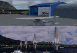
These are actually two sceneries offered in one pack. I started building the small airport of Mesolonghi in Western Greece. When nearing completion, I thought that FS was really missing the big suspension Bridge that connects mainland Greece with Peloponese that was finished in 2004, being the biggest in the world of the fully suspended type. The bridge project turned out bigger than the airport as I ended up doing the typical, Greek-style double ended ferries that served the straights for decades before the bridge and still offer a cheaper and, to some, more relaxing alternative.
Mesolonghi airport is situated 5 kilometers east of the historic city of Mesolonghi and is close to the technical school of fisheries. There is no ICAO code (ZZZZ) so I had to give it the fictional LGME in the sim. A purely day field, it houses the local Aeroclub and ultralight school. due to its small size and hospitable atmoshpere, it is a popular GA pilots destination, receiving also often international arrivals. The runway is asphalt and 800m (2635') in length. No PAPI or VASI are provided. There is no tower service and unicom frequency of 119.7MHz is used by the traffic. Closest controlled airport is Araxos (LGRX), a civil and military field, quite common in Greece, 12.5 nautical miles S-SE. The nearby city of Mesolonghi is famous for its heroic resistance and fall in 1826 during the Greek war of indepence. It is also famous for its fishery production, due to the natural lagoon, formed by the shallow waters.
Features of the Mesolonghi airport scenery include:
- Photoreal area with seasonal variations and watermask.
- Custom hangars and containerised buidings.
- AI default trike performing TnGs (in P3D it will work only if you copy over the FSX trike).
- The technical shool of fisheries on the north side.
- Customized shorelines, to fit with ORBX Global Vector.
- Optional shoreline fix for default scenery.
The Rio-Antirio bridge is located 14.5 nautical miles to the east of the airport. It connects the towns of Rio on the south side and Antirio on the north side. More data on the bridge can be found on Wikipedia.
Features of the Rio-Antirio bridge scenery include:
- Custom bridge model, bump mapped textures with hard platform surface and vehicle traffic.
- Night lighting textures and custom roadlights.
- Photoreal scenery for north and south shores, including hand placed autogen and night textures.
- Custom castle models on north and south sides, with bump mapped textures and night lighting.
- Custom model of the toll post on the north side.
- Custom AI ferry boats with constant shuttle service between Rio and Antirion piers.
- Customized shorelines, to fit with ORBX Global Vector.
- Optional shoreline fix for default scenery.
- Optional HDR optimized photoreal textures.
| Filename: | Mesolonghi_Airport__RioAntirio_Bridge__Greece___UP.zip |
| License: | Freeware |
| Added: | 16th March 2016, 09:15:21 |
| Downloads: | 2,628 |
| Author: | Vassilios Dimoulas |
| Size: | 300.05 MB |
| Category: Flight Simulator X - Scenery | |
| KGSP - Greenville-Spartanburg International Airport - South Carolina, USA |
|
Images related to this file:
File Description:
Greenville-Spartanburg South Carolina International Airport for FSX. Several improvements have been made to the default airport, including replacing the default terminal with new buildings modelled in FSDS, correctly numbering and coding gates using Airport Design Editor 1.67.5684, creating a new vehicle network, adding ample GA parking, changing the tower view to the roof of the control tower, including the FedEx cargo area with static FedEx trucks, trailers, and warehouse. Also included are Jim Dhaenen's excellent ramp lights and a set of GA flight plans made using AI flight Planner using all FSX default aircraft to liven up the GA area, and the option to include moving road traffic on the approach to Runway 4. Please read the README FIRST.txt and installation.txt files to insure proper installation of all files.
| Filename: | KGSP__GreenvilleSpartanburg_International_Airport_.zip |
| License: | Freeware, limited distribution |
| Added: | 10th June 2016, 21:15:42 |
| Downloads: | 1,671 |
| Author: | Patrick Finch |
| Size: | 3.23 MB |


© 2001-2026 AVSIM Online
All Rights Reserved
Privacy Policy |