
Where Flight Simulation Enthusiasts Gather from Around the World!
AVSIM Library - Search Results

| Category: Flight Simulator X - Scenery | |
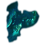
| Rock Sound - The Bahamas (MYER) |

|
Images related to this file:
File Description:
This scenery includes rework of the runway, taxiways, aprons and parking; custom scenery objects; placement of library objects and landclass changes compatible with UTX-TAC in the vicinity of MYER. It is based on Google Earth imagery and photos taken by Harrington Mallory.
| Filename: | Rock_Sound__The_Bahamas_MYER.zip |
| License: | Freeware |
| Added: | 21st November 2012, 01:56:51 |
| Downloads: | 1,306 |
| Author: | Art Poole |
| Size: | 1.18 MB |
| Category: Flight Simulator X - Scenery | |
| The Dry Tortugas Photo Scenery |
|
Images related to this file:
File Description:
Where are the Dry Tortugas? Should you be wondering, at the western end of the Florida Keys. Located 68 miles west of Key West, they are accessible only by boat and of course via your favorite seaplane.
Source Data: National Agriculture Imagery Program (NAIP) Orthoimagery, 1 meter per pixel resolution. The scenery package also corrects the MS-FSX Island and Lighthouse position errors overlooked by UTX-USA and UTX-TAC.
For your finest virtual experience it is highly recommended you download, install and use with: South Florida and The Bahamas Water Class scenery. (S-FL_Bahamas_WC.zip)
Enjoy your flight and don't forget your Scuba Gear or the sunscreen! - Wally-Bob
| Filename: | The_Dry_Tortugas_Photo_Scenery.zip |
| License: | Freeware, limited distribution |
| Added: | 23rd August 2014, 11:08:17 |
| Downloads: | 917 |
| Author: | Walter Roberts |
| Size: | 50.9 MB |
| Category: Flight Simulator X - Utilities | |
| Addon Voice for the Mechanic |
|
File Description:
First release of a new recorded voice for the Mechanic for 'Multi Crew Experience. Read-me included. Very simple install.If you have any problem or suggestions then please visit the MCE forum here on AVSIM.
| Filename: | Addon_Voice_for_the_Mechanic.zip |
| License: | Freeware |
| Added: | 16th August 2012, 03:39:16 |
| Downloads: | 1,486 |
| Author: | Clive Joy |
| Size: | 15.28 MB |
| Category: Flight Simulator X - Missions | |
| Lost in the Snow FIXED |
|
File Description:
This is my third resuce mission. Two inexperience hikers decide to do some winter backpacking on a trail in the White Mountains of New Hampshire and get lost in a snowstorm. You have been called to help search for them
This mission is rated EXPERT. There are no pointers in the mission, you must be able to understand a areonotic sectional chart and know how to navigate using VOR(s) to locate both the hiker and the hospital. You MUST be experienced in flying a helicopter and be able to hover over an area. Read the MISSION BREIFING document, it has all the information required for this mission.
| Filename: | Lost_in_the_Snow_FIXED.zip |
| License: | Freeware |
| Added: | 24th April 2007, 00:36:56 |
| Downloads: | 2,767 |
| Author: | David J Crandall |
| Size: | 22.51 MB |
| Category: Flight Simulator X - Scenery | |
| Iguassu Falls - Save The Planet |
|
Images related to this file:
File Description:
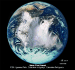
The Iguassu Falls, Itaipu Hydroelectric Power Plant, Foz do Iguassu City and Land Class Package for FSX
Save The Planet is my version of the Iguassu Falls, Itaipu Dam, bridges and landclass scenery for FSX.
Differently from my other version for MSFS 2004, I created a mesh of 5 meter resolution for Iguassu Falls area
to give me some idea how I could proceed. So, I decided to use on this addon
an image background avaliable at server (VirtualEarthSatellite). Thanks Microsoft.
Non-Airport Scenery - ICAO (SBFI). coming soon at www.Terra-Brasilis.org
Portuguese: Cataratas do Iguassu,
Spanish: Cataratas del Iguazu are waterfalls of the Iguassu River located on the border of the Brazilian state of Parana (in the Southern
Region) and the Argentinian Province of Misiones.
The Falls are shared between the Iguazu National Park (Argentina) and Iguacu
National Park (Brazil). The parks were designated UNESCO World Heritage Sites.
The Itaipu Hydroelectric Power Plant is located in the Parana River, in the stretch of the frontier between Brazil and Paraguay, 14 km north of the Friendship Bridge.
The area of the project extends from Foz do Iguassu, in Brazil, and Ciudad del Este, in Paraguay, in the south, up to Guaira (Brazil) and the Guaira Falls (Paraguay), in the north.
Enjoy FSX Iguassu Falls Scenery!
| Filename: | Iguassu_Falls__Save_The_Planet.zip |
| License: | Freeware |
| Added: | 9th December 2010, 01:57:00 |
| Downloads: | 2,845 |
| Author: | Cicero Costa |
| Size: | 31.71 MB |
| Category: Flight Simulator X - Missions | |
| The Most Dangerous Airports: Toncontin |
|
Images related to this file:
File Description:
I have created the next in, The Most Dangerous Airport Mission Series: namely Toncontin. The missions are real and hectic, both for you and the aircraft. The flight is a scheduled Continental Airlines flight. The Toncontin Intl is rated by some as the most dangerous airport, due to it's approach, it has a 180�° left bank, just before landing on runway 02. The airport is not so famous for this approach and numerous accidents have closed the airport in 2008 but it has been reopened after a serious upgrade.
The setting are as follows: Time and weather are set as Online Day Weather and Stormy FSX Day weaqther. Due to the runway 02 approach not being programmed into FSX, ignore the ATC vectoring and fly the approach indicated on the GPS and mission pointer. The approach is adapted from the real approach charts.
| Filename: | The_Most_Dangerous_Airports_Toncontin.zip |
| License: | Freeware |
| Added: | 24th February 2010, 05:10:45 |
| Downloads: | 2,187 |
| Author: | Robbie Albers |
| Size: | 15.9 MB |
| Category: Flight Simulator X - Aircraft Repaints, Textures and Modifications | |
| B-17G Stingy |
|
Images related to this file:
File Description:
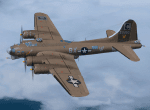
This folder contains a repaint for the accu-sim version of the A2A B-17G Flying Fortress. The B-17G-1-BO 42-31053 ���«Stingy���» was operated from several UK wartime bases (the last was Snetterton Heath).
On a training flight on 11 October 1944 Stingy crashed at Woodend after being involved in a mid air collision with two other B-17's. Stingy participated in several missions, among them over Regensburg and Poznan.
| Filename: | B17G_Stingy.zip |
| License: | Freeware |
| Added: | 12th February 2011, 10:54:09 |
| Downloads: | 513 |
| Author: | A2A Simulations/Gunnar van der Meeren |
| Size: | 16.15 MB |
| Category: Flight Simulator X - Aircraft Repaints, Textures and Modifications | |
| Boeing 737-800 Air Algerie livery (Default FSX aircraft, not for any addon version of the 737) |
|
File Description:
Boeing 737-800 livery designed for the default 737-800 available in Flight Sim X.
by Zergoun Aissa
| Filename: | Boeing_737800_Air_Algerie_livery_Default_FSX_aircr.zip |
| License: | Freeware, limited distribution |
| Added: | 15th August 2023, 14:45:25 |
| Downloads: | 40 |
| Author: | Zergoun Aissa |
| Size: | 2.96 MB |
| Category: Flight Simulator X - Gauges | |
| V-One Gauge for B727-100/F 727-200/F with Call-Outs |
|
Images related to this file:
File Description:
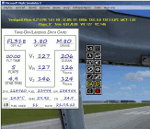
This gauge is written specifically for Captain Sim's B727-100/F and B727-200/F aircraft (http://www.captainsim.com/products/x727/). It will inform you of appropriate take-off speeds (V-speeds), take-off trim units, Vref landing speeds, elapsed flight time, fuel used, optimum cruise altitude, optimum ERP setting and Maximum Climb Thrust (MCT). It will also indicate when the aircraft's gross weight has been exceeded by displaying in red text. Take-off speeds are adjusted for altitude and temperature values. Flight time and fuel used can be reset at any time by clicking on their respective displays. Pounds (LB), Kilograms (KG), Celsius (C) and Fahrenheit (F) are toggled by a click on their displays. Provisions have been made to allow user adjustments to Optimum Altitude, Optimum EPR and Center of Gravity values. Seven F/O take-off call-outs are included: 80 knots, V1, VR, V2, Gear-up, Flaps-up and Slats Retract. A trim wheel sound is also included.
| Filename: | VOne_Gauge_for_B727100F_727200F_with_CallOuts.zip |
| License: | Freeware, limited distribution |
| Added: | 22nd July 2012, 08:07:50 |
| Downloads: | 2,598 |
| Author: | Paul Tally |
| Size: | 1.1 MB |
| Category: Flight Simulator X - AFCAD Files | |
| Somerset Airport (KSMQ), NJ |
|
File Description:
Located 03 miles N of Somerville, New Jersey on 210 acres of land, Somerset is a public airport with one asphalt and two grass runways, the longest of which is 2733' in length. The turf runways have no hard surfaces and you will be landing on terrain so have your mesh set as high as possible - both runways are still selectable in the ATC window for landing/takeoff announcements. AI aircraft will not use them. The helipad is a start location in front of the main terminal if a parking location is not wanted to begin helicopter flights. Parking is divvied up into three categories - GA_SMALL spots will accommodate aircraft with wingspans no greater than 40 feet. GA_MEDIUM spots will accommodate aircraft with wingspans no greater than 60 feet. GA_LARGE spots are named to identify locations suitable for starting in a glider if you wish to do so. They can also accommodate aircraft with wingspans no greater than 60 feet. In addition to tie downs, there are 13 hangars open for parking in various locations - they can be identified by GA_DOCK. Only the N Parking hangar can accommodate aircraft with wingspans no greater than 60 feet - all other hangers are suitable only for aircraft with wingspans no greater than 40 feet. Several of the hangars have attendants - look beside the doors for the NAV2 frequency to set for opening them. AI aircraft will only spawn on the north tarmac/hangars (largely to prevent AI traffic crossing the runway on taxi). All objects and static aircraft in the immediate vicinity of parking and taxiways have collision disabled. If your aircraft has a wingspan greater than 40 feet it is NOT recommended that you taxi down the middle taxiway leading to the main tarmac from N Parking as you will not clear the hangars - go either via the NW taxiway past the grass tie downs (NW Parking) or around East to the next taxi way on the other side of the east hangars (E Parking) which has more wing clearance. Fuel is available on both tarmacs north and south of the runway by stopping on the asphalt in front of the tanks/pump.
Scenery constructed with use of satellite images/streetview/aerial photos - the author has not been there in person.
This scenery is meant to be used in conjunction with MegaScenery Earth New York 005. It is not required, but apron use is minimized to allow satellite scenery to show through as much as possible, and objects are placed based on the MSE textures - lack of it may make scenery look out of place.
| Filename: | Somerset_Airport_KSMQ_NJ.zip |
| License: | Freeware |
| Added: | 27th September 2011, 01:15:53 |
| Downloads: | 306 |
| Author: | Drew Sikora |
| Size: | 1.47 MB |
© 2001-2026 AVSIM Online
All Rights Reserved
Privacy Policy |