
Where Flight Simulation Enthusiasts Gather from Around the World!
AVSIM Library - Search Results

| Category: Flight Simulator X - Missions | |
| Welcome to the Company |

|
Images related to this file:
File Description:
This mission for FSX is based on a fictional charter company, "Idaho Air Services." This is the pilot's first flight with the new company in the Idaho Backcountry. Estimated time to complete this flight is 30 minutes. The mission was created using ORBX NRM and the Carenado C185 Tundra.
| Filename: | Welcome_to_the_Company.zip |
| License: | Freeware |
| Added: | 28th July 2013, 18:40:37 |
| Downloads: | 496 |
| Author: | Brett Lee |
| Size: | 2.15 MB |
| Category: Flight Simulator X - Missions | |
| FSX Get the Bogey! |
|
Images related to this file:
File Description:
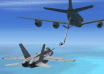
Take off in a F/A-18 Hornet from an aircraft carrier, intercept an unresponsive intruder aircraft, escort it to a nearby AFB, meet with a KC-135 tanker plane, refuel in flight, return to the carrier and land safely. - This mission requires the Acceleration expansion pack. In addition you will have to install one additional aircraft (a KC-135 tanker plane: http://library.avsim.net/download.php?DLID=147793), Javier Fernandez' carrier package (http://flightsimulatorxworld.com/downloads/USS_NIMITZ_IKE.rar) and a small utility called SimVar.exe (included).
| Filename: | FSX_Get_the_Bogey.zip |
| License: | Freeware |
| Added: | 23rd March 2011, 04:44:08 |
| Downloads: | 2,223 |
| Author: | Robin Hutter |
| Size: | 18 MB |
| Category: Flight Simulator X - Scenery | |
| Chernobyl NPP & The Zone |
|
File Description:
Landmark scenery for Microsoft FSX. Built with Sp2 and Acceleration. Not tested with any previous version. Includes a custom built Reactor building, but most of the rest you will see uses default FSX objects placed with OPT.
| Filename: | Chernobyl_NPP__The_Zone.zip |
| License: | Freeware |
| Added: | 13th May 2008, 21:22:39 |
| Downloads: | 2,823 |
| Author: | Mike d. Dalgleish |
| Size: | 597.04 KB |
| Category: Flight Simulator X - Scenery | |
| Mayaguana (MYMM) - The Bahamas |
|
Images related to this file:
File Description:
Mayaguana is the easternmost island in the Bahamas with Bahamasair providing Nassau and Inagua air connections. The airport utilizes part of an abandoned 11,000 foot USAF runway. The runway is listed as 7300 foot long, but 2400 feet on the east end is closed indefinitely. A new terminal building was completed, but no apron or taxiway connects it to the runway so it is unoccupied. Construction was started on another terminal, apron and taxiway as well as runway repaving, but the project is currently abandoned. All of the aforegoing is represented by this scenery. The scenery includes custom scenery objects; placement of library objects and landclass changes. Scenery is based on Bing Maps and photos taken locally, and it is optimized for use with UTX-TAC.
| Filename: | Mayaguana_MYMM__The_Bahamas.zip |
| License: | Freeware |
| Added: | 20th April 2013, 20:18:45 |
| Downloads: | 1,120 |
| Author: | Art Poole |
| Size: | 1.04 MB |
| Category: Flight Simulator X - Scenery | |
| Inagua - The Bahamas (MYIG) |
|
Images related to this file:
File Description:
MYIG is the southernmost airport in the Bahamas. At nearby Matthew Town is the Morton Salt Company's main facility - Inagua's main industry. The scenery includes custom scenery objects; placement of library objects and landclass changes. The airport is also moved to it's proper location. Scenery is based on Google Earth and Microsoft Bing imagery and photos taken locally, and it is optimized for use with or without UTX-TAC.
| Filename: | Inagua__The_Bahamas_MYIG.zip |
| License: | Freeware |
| Added: | 21st December 2012, 18:12:48 |
| Downloads: | 1,252 |
| Author: | Art Poole |
| Size: | 365.77 KB |
| Category: Flight Simulator X - Scenery | |
| Bimini, The Bahamas (MYBS) |
|
Images related to this file:
File Description:
Both North and South Bimini islands landclass, shorelines and water, as well as the South Bimini Airport, have been redone per Google Earth images. This is NOT photo scenery.
| Filename: | Bimini_The_Bahamas_MYBS.zip |
| License: | Freeware |
| Added: | 7th March 2010, 12:08:16 |
| Downloads: | 2,677 |
| Author: | Art Poole |
| Size: | 314.96 KB |
| Category: Flight Simulator X - Scenery Design | |
| Using the Autogen Annotator |
|
Images related to this file:
File Description:

The Autogen Annotator is a powerful tool for modifying the autogen of default ground textures or adding autogen to custom (photo-real) ground.
This document illustrates the use of the tool, and includes a pictorial guide to all autogen object types.
Very sorry - no support of any kind is offered. Please do not write. For any questions, please post in the Avsim Scenery Design Forum.
| Filename: | Using_the_Autogen_Annotator.zip |
| License: | Freeware |
| Added: | 21st November 2009, 16:18:51 |
| Downloads: | 5,816 |
| Author: | Luis Feliz-Tirado |
| Size: | 8.72 MB |
| Category: Flight Simulator X - Scenery | |
| The Millau Viaduct Bridge |
|
File Description:
The Millau Viaduct is a large cable-stayed road-bridge, designed by Norman Foster that spans the valley of the River Tarn near Millau in southern France. Coordinates 44°04'46"N - 03°01'20"E .
It is the tallest vehicular bridge in the world.
Modelling with the SDK-SP2.
| Filename: | The_Millau_Viaduct_Bridge.zip |
| License: | Freeware, limited distribution |
| Added: | 24th March 2008, 11:23:06 |
| Downloads: | 5,809 |
| Author: | Jean-Claude Irle |
| Size: | 242.65 KB |
| Category: Flight Simulator X - Scenery | |
| The Real VCBI X |
|
Images related to this file:
File Description:

This is the complete & high detailed scenery of Bandaranaike International Airport
for Microsoft Flight Simulator X. If you are a Sri Lankan flightsimmer or like to fly
around Sri Lanka in Flight Simulator X, then this is a must for you!.
Features -: High quality Satellite terrain.
G-Max�������® designed terminal and other buildings.
Accurate building and apron placement.
Extremely high detailed terminal and surroundings.
Re-Adjusted glide scope and localizer to match actual situation.
Road traffic animations and other effects.
High detailed Autogen data.
| Filename: | The_Real_VCBI__X.zip |
| License: | Freeware, limited distribution |
| Added: | 4th October 2011, 08:00:05 |
| Downloads: | 8,601 |
| Author: | Gayan Liyanaarachchi |
| Size: | 22.65 MB |
| Category: Flight Simulator X - Utilities | |
| Slewable Control Tower |
|
Images related to this file:
File Description:

WHAT IS IT?
In a nutshell, the stock FSX control tower turned into an airplane with the aerodynamics of a cement brick with highly adjustable landing gear for tower height. No longer does one have to create a multiplayer session to use the stock control tower to do some AI "plane watching". The control tower is fitted with floats so one can slew to a good vantage point at certain airports like Boston Logan, La Guardia or KSFO for instance, floating on water. (Yes, it still "bobs" with waves) This was also done for better stability on uneven ground and the inability to roll around. There are some new features added such as tower flood lighting, a reference switch, and an external program to adjust the tower height (30-1000 ft.) for convenience. ( Not tested at all in P3D )
| Filename: | Slewable_Control_Tower.zip |
| License: | Freeware, limited distribution |
| Added: | 6th September 2013, 15:30:05 |
| Downloads: | 662 |
| Author: | Roman Stoviak |
| Size: | 770.98 KB |
© 2001-2026 AVSIM Online
All Rights Reserved
Privacy Policy |