
Where Flight Simulation Enthusiasts Gather from Around the World!
AVSIM Library - Search Results

| Category: Flight Simulator X - Scenery | |
| Pagasa Island, Philippines |

|
Images related to this file:
File Description:
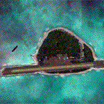
Pagasa Island is a jewel in the South China Sea. It is the one pictured - an emerald splash in an azure sea slashed by a coral runway - whenever new collisions or confrontations are reported in the news for the region. Occupied continuously by the Philippines since 1971, historical use dates back to the Han dynasty, which many believe forms the basis of the Chinese claim to the island. Each country has it's own interpretation of international law and the Filipinos are clearly banking on the precedence of continuous occupation, at no small expense, as Rancudo Field is the farthest airport from Manila within the Philippine sphere of control.
Surprisingly, the geography of the island serves to capture and retain rainwater, although the aquifer is stagnant and the water must be treated for consumption. Sea life remains abundant, poachers take coral heads and sea turtles. There is a solar farm and recently installed solar street lights, fuel for the generators is a precious commodity this far from the mainland.
Sadly, nature may solve the struggle for possession by withdrawing the island from the arena. It is believed that the construction of the runway may have compromised the islands basic integrity, allowing it to crumble into the sea. Whatever the cause, the evidence is clear. Bunkers built during the Japanese occupation in WWII are already slipping beneath the waves and the rate of salt water encroachment has been recorded at close to 6" per day.
There are some things to explore, the grounded BRP Laneo Del Norte to the west; over to the north near the resort grounds are a dugout fishing canoe and some authentic Philippine bangka boats; you may want to load up and head east to do some low warning passes over the Chinese fishing fleet. Standing at the east end of the field, you can just barely spot the China Coast Guard cutter's smoke on the horizon.
The tower is marked by a bright strobe that fires once every five seconds and at night it is bright enough to guide you back to the island from the distance of the fleet. There are no published procedures and the tower is not staffed. Airport ICAO is RPPN.
| Filename: | Pagasa_Island_Philippines.zip |
| License: | Freeware, limited distribution |
| Added: | 10th May 2014, 12:21:19 |
| Downloads: | 1,854 |
| Author: | Rick Keller |
| Size: | 16.17 MB |
| Category: Flight Simulator X - Scenery | |
| FSX Grand Canyon North Rim Simulation |
|
Images related to this file:
File Description:
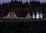
Welcome to the North Rim of the Grand Canyon!
This scenery is a mostly fictitious representation of what the North Rim might look like of it had been developed like the South rim. A new airport (KKPA, Kaibab Plateau Airport) is the centerpiece. It sits at 8,730 ft MSL so density altitude is a real issue. Runway 17/35 is 6,500ft long so biz jets can get in and out safely. A new resort sits atop the ridge to the east [Eagle's Nest]. There is a helipad for access. An NDB makes finding it easier [AZ95 220.9 kHz]. Or you can just follow the traffic on the access road that branches off from highway 67 just south of the airport. To the north I have added a gravel strip to Jacob Lake where 67 joins 89A. Runway 14/32 is 3000 ft long and sits at 7900 ft MSL. An NDB [AZ93 393 kHz] is included. At the south end of Highway 67 sits the North Rim Visitor Center. There is a helipad on the roof for those who like rotary wing challenges. The NDB is AZ94 at 423.4 kHz. The entire length of Highway 67 is represented with traffic going both ways. You will see
air traffic from KGCN at the South Rim and traffic between KKPA and Jacob Lake.
| Filename: | FSX_Grand_Canyon_North_Rim_Simulation.zip |
| License: | Freeware, limited distribution |
| Added: | 19th May 2021, 19:28:12 |
| Downloads: | 100 |
| Author: | Brett Delana |
| Size: | 16.26 MB |
| Category: Flight Simulator X - Original Aircraft | |
| Avia BH-5 & Avia Bk.11 |
|
File Description:
The plane was constructed according to the type BH-1, the first successful plane produced by the Avia Works. It was an all-wooden two-seat training, sports and messenger plane, which was bigger than BH-1, more solid and more sophisticated, in its aerodynamics and technology. It was designed for flying basic acrobatics. The BH-5 was the first Czechoslovak plane to win an international contest and thus received the King of Belgium‘s Prize and the prize of the Belgian Tourist Aircraft Contest in 1923. The pilot, Zdenìk Lhota, flew to Brussels and back with a layover in Mayence at an average speed of 138 km/h. In 1923 this was a remarkable performance, not only in the sport-plane category. In 1923, the type BH-5 also won the “D“ category in the President of the Republic’s Contest. The Walter NZ-60, a radial five-cylinder engine, was installed in the BH-5 plane; it was the very first and a very successful engine designed by the Walter Company. Based on the results of military tests of the BH-5s, the Ministry of Defense placed an order for a series of slightly improved BH-9, BH-10 and later also BH-11 Avias, which had been successful in many national, as well as international contests and also in record and promotion flights. The BH-5 Avia plane was marked L-BOSA; thanks to this mark, all the planes of this very successful series were nicknamed “boska“. This addon has detailed 3D model and VC, original sounds, real flight dynamics and manual.
| Filename: | Avia_BH5__Avia_Bk11.zip |
| License: | Freeware, limited distribution |
| Added: | 8th December 2007, 23:10:17 |
| Downloads: | 3,730 |
| Author: | Štìpán Obrovský, Czechoslovak Historic Flight www.hictoricflight.cz |
| Size: | 31.66 MB |
| Category: Flight Simulator X - Aircraft Repaints, Textures and Modifications | |
| FSX/P3D/FS2004 Saturn Airways DC-6B 1963 |
|
Images related to this file:
File Description:

This is a repaint of a DC-6B in Saturn Airways 1963 colors. The freeware CalClassic DC-6B by Greg Pepper and Tom Gibson is needed for this repaint. Saturn was founded in 1948 as "All-American Airways" and, as a supplemental carrier, it flew cargo and tour flights. It's main business was with the U.S. military. In 1964 it got the authority by the CAB to operate tranatlantic flights. Then, in 1965 AAXICO, a major military contract supplemental, submerged itself into Saturn. Tragically, two DC-6s were lost in accidents in January 1967, of which one was fatal. Later that year, Saturn became a public corporation. The fleet by 1968 comprised of DC-8-61s, DC-8-55Fs, DC-7CFs and DC-6As. In its first year of Jet operations they got a 49% increase in revenue. By 1971 Saturn was the 5th largest U.S. supplemental, and in 1972 they received their first of 12 Lockheed L100-30 Hercules. In 1974 Saturn got into merger talks with Trans International, and posted its largest net profit ever with gains of $4.9 million. The two airlines' application for the merger was approved by the CAB in 1976. Thus, on November 30 1976, the company merged into Trans-International Airlines (TIA). This repaint is of DC-6B N90770, which flew for them from 1961 to 1964. Textures are 32bit bmp.This repaint was tested on FSX-SE and should work on FSX & P3D v1-3. It should also work on FS2004.
| Filename: | FSXP3DFS2004_Saturn_Airways_DC6B_1963.zip |
| License: | Freeware |
| Added: | 5th July 2019, 17:29:09 |
| Downloads: | 55 |
| Author: | Ted Giana |
| Size: | 7.87 MB |
| Category: Flight Simulator X - Scenery | |
| Lord howe Island and Balls Pyramid |
|
File Description:
This is a complete replacement for the default Lord Howe Island in Flight Simulator X and provides the following: Accurate coastlines, beaches, roads etc. - Accurate placement of settlements, golf course, etc. - Terrain mesh based on SRTM 90m data - Updated Lord Howe Island airport (YLHI) - GMax model of the Balls Pyramid rock outcrop - Updated landclass and waterclass - Boat traffic in the waters around the island
| Filename: | Lord_howe_Island_and_Balls_Pyramid.zip |
| License: | Freeware, limited distribution |
| Added: | 10th June 2007, 23:57:49 |
| Downloads: | 3,340 |
| Author: | Don Bush |
| Size: | 603.88 KB |
| Category: Flight Simulator X - AFCAD Files | |
| LFPG AFCAD default Scenery |
|
File Description:
This AFCAD is for Paris Charle de Gaulle -LFPG-airport. It will greatly improves the default one. Gates have been added. Taxiwaysigns have also been completely reworked and CAT I/CAT III lights also added. the new Terminal S3 is also shown but in a very simple way. Aprons guidance lights and stop lines/lights are available.
Please read the readMe/lisezMoi for more informations.
| Filename: | LFPG_AFCAD_default_Scenery.zip |
| License: | Freeware |
| Added: | 16th May 2007, 15:22:34 |
| Downloads: | 2,550 |
| Author: | Xavier Ossedat |
| Size: | 107.99 KB |
| Category: Flight Simulator X - AFCAD Files | |
| Leeward Point Field - Guantanamo Bay, Cuba (MUGM) |
|
File Description:
By request, here is an updated version of the stock FSX Leeward Point Field. I used Flight 1's AFX and
Instant Scenery programs to re-work the airport. I removed and replaced some of the stock buildings, moved
the control tower, added several buildings, added Military combat and cargo parking, additional pavement and
several static items such as vehicles and a few trees.
| Filename: | Leeward_Point_Field__Guantanamo_Bay_Cuba_MUGM.zip |
| License: | Freeware |
| Added: | 11th May 2008, 19:10:16 |
| Downloads: | 1,317 |
| Author: | Jim Cook |
| Size: | 7.49 KB |
| Category: Flight Simulator X - Scenery | |
| Leconfield EGXV RAF Air Sea Rescue Airbase in the UK |
|
File Description:
Leconfield was an operational RAF base until the 70's and is now home to the Defence School of Transport and E Flight 202 Sqdn Air Sea Rescue, using Sea King Helicopters.
The scenery was created purely for my own interest and is not designed to be totally accurate. The idea is simply because it is my nearest airport and I like to fly from there.
| Filename: | Leconfield_EGXV_RAF_Air_Sea_Rescue_Airbase_in_the_.zip |
| License: | Freeware, limited distribution |
| Added: | 7th June 2008, 15:24:49 |
| Downloads: | 1,492 |
| Author: | Stewart W Allen |
| Size: | 464.97 KB |
| Category: Flight Simulator X - Panels | |
| ATC QNH and QFE fix on info screen for muliplayer |
|
File Description:
I was fed up with the default ATC screen in FSX only showing pressure settings in inches of mecury so this is my convert to show QNH in millibars. The new panel also shows the QFE for an airport. Altimeter can still be used by clicking over the QNH with mouse. You will need to replace the radar.cab file with this one in your gauges directory.
| Filename: | ATC_QNH_and_QFE_fix_on_info_screen_for_muliplayer.zip |
| License: | Freeware |
| Added: | 4th June 2008, 19:09:49 |
| Downloads: | 458 |
| Author: | Dave Hirst |
| Size: | 24.74 KB |
| Category: Flight Simulator X - Scenery | |
| Free Flight Mode Project - Midwest Flyin |
|
File Description:
This add-on will modify the FSX Mission "Midwest Flyin" so that the mission scenery, animations, and even sound effects will all be visible in free flight mode. Also included are AFCAD modifications for each airport, the smaller, private field is now AI-Ready.
Please note the original scenery in this package was designed by Microsoft, I just modified the file types to accomplish the above.
| Filename: | Free_Flight_Mode_Project__Midwest_Flyin.zip |
| License: | Freeware, limited distribution |
| Added: | 27th October 2008, 07:09:48 |
| Downloads: | 517 |
| Author: | Dakota Smith / Smith Graphics / Microsoft |
| Size: | 12.85 KB |


© 2001-2026 AVSIM Online
All Rights Reserved
Privacy Policy |