
Where Flight Simulation Enthusiasts Gather from Around the World!
AVSIM Library - Search Results

| Category: Flight Simulator X - Scenery | |
| LFFZ - Sezanne |

|
Images related to this file:
File Description:
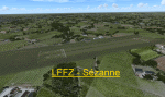
Scenery LFFZ Sezanne V1.0 for FSX
Tested with SP2 Acceleration + UTX Europe.
V1.0: Initial version
This file modifies the airfield Sezanne in FSX. It was made with ADE (Airport Design Editor), SbuilderX and Whisplacer.
Thank you to the respective authors and Patrick Renaudin for its objects.
Sezanne is a commune in the Marne department in Champagne-Ardenne region in north-eastern France.
| Filename: | LFFZ__Sezanne.zip |
| License: | Freeware |
| Added: | 2nd June 2010, 01:44:58 |
| Downloads: | 1,193 |
| Author: | Stephane Gouzon |
| Size: | 3.41 MB |
| Category: Flight Simulator X - Original Aircraft | |
| Andalus Embraer ERJ-145MP/EU |
|
Images related to this file:
File Description:

Andalus Lineas Aereas was a Spanish airline based in the Malaga Airport. The February 27, 2009 made its first flight with passengers. It was formed mainly by managers with over thirty years of experience working in airlines, and its capital was 100% of Andalusian investors. Addons, FMC, Callouts, GPWS, Groundhandling (two textures). Model Project Open Sky (with VC), texture by Juan Villamor.
| Filename: | Andalus_Embraer_ERJ145MPEU.zip |
| License: | Freeware |
| Added: | 6th December 2015, 14:39:06 |
| Downloads: | 1,527 |
| Author: | Juan Villamor |
| Size: | 49.55 MB |
| Category: Flight Simulator X - Scenery | |
| Stansted Xtreme |
|
Images related to this file:
File Description:
Extremely accurate scenery for London Stansted Airport. Includes large amount of animation vehicles, replacement AFCAD file. All textures made to the highest standard based on actual photographs. This new Version also has a new Lighting system, the renamed runway 22-04 and the new RyanAir Hanger
DEMO FILE, fully functional but has 'demo signs' - Full price £13.00(GBP)
| Filename: | Stansted_Xtreme.zip |
| License: | Commercial demo |
| Added: | 18th December 2009, 13:35:37 |
| Downloads: | 2,162 |
| Author: | G. Summons, UK2000 scenery |
| Size: | 44.88 MB |
| Category: Flight Simulator X - Scenery | |
| SVVA X "RePack" |
|
Images related to this file:
File Description:
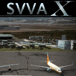
First, before install, This is a repackaging, which contains all elements of the original scene of my creation SVVA X along with improved "AGN" and other improvements and corrections of the original scenario, all in one, so you must remove all the elements from all previous SVVA before installing this new version.
Arturo Michelena Intl Airport (SVVA) - Venezuela for FSX.
| Filename: | SVVA_X_RePack.zip |
| License: | Freeware |
| Added: | 9th May 2015, 18:06:41 |
| Downloads: | 3,265 |
| Author: | Jonathan Blanco |
| Size: | 81.06 MB |
| Category: Flight Simulator X - Utilities | |
| Increased visibility of ground marks (taxi & runway lines) |
|
File Description:
Are you tired of not being able to distinguish the ground markings correctly? Well now, and without losing the effect of reality, lines can be seen better, even at night. The holding point, runway headers, white lines and header numbering are reinforced, even so that with the light of the aircraft and the airport itself they can be visible from your cockpit.
| Filename: | Increased_visibility_of_ground_marks_taxi__runway_.zip |
| License: | Freeware |
| Added: | 10th January 2021, 21:38:46 |
| Downloads: | 398 |
| Author: | Cristóbal Laje Ros |
| Size: | 6.17 MB |
| Category: Flight Simulator X - Utilities | |
| Universal Take Off Performance Information Application (UTOPIA) 1.3 |
|
File Description:
This is the Universal Take Off Performance Calculator (UTOPIA) Version 1.3. UTOPIA suggests a derate for a number of aircraft at a given runway, weight and weather conditions. New version brings Engine Derate and calculation method options, auto airport, improved TOPL calcs and other minor tweaks. New take off data files for : QW788, QW789, QW BAe146 and RJ and Wilco A340-600 TOD.
| Filename: | Universal_Take_Off_Performance_Information_Applica.zip |
| License: | Freeware |
| Added: | 1st October 2018, 18:31:03 |
| Downloads: | 28,774 |
| Author: | Ian Webber |
| Size: | 961.84 KB |
| Category: Flight Simulator X - AFCAD Files | |
| V2 Christchurch Intl - NZCH - New Zealand |
|
File Description:
ADE Home Edition (Freeware) was used to design these BGL files: This is an update of my previous version, my previous version not required, these 2 files are only for the FSX default airport: one with the Xwind rwy 11/29 activated where both rwy's will now be used for takeoff/landing and one as default: all taxiways now updated to the Nov 07 AIP NZ ground movement charts, all taxisigns changed to match the taxiways with missing taxisigns added, assigned parking with extra parking, and for the Canterbury Aero Club the grass rwy 2L/20R is now open and start locations added, support vehicle roads rebuilt, extra fuel trucks and several other improvements, airport views are from the roof of control tower (when in tower view) fully tested with Ultimate Traffic/WOAI but not required, please view the readme before installation
| Filename: | V2_Christchurch_Intl__NZCH__New_Zealand.zip |
| License: | Freeware |
| Added: | 13th December 2007, 08:34:27 |
| Downloads: | 2,409 |
| Author: | Ray Smith |
| Size: | 17.1 KB |
| Category: Flight Simulator X - AFCAD Files | |
| New Hampshire & Vermont - 21 Airports Package |
|
Images related to this file:
File Description:
This package contains 21 airports in New Hampshire and Vermont. These airports are intended to be used with FSX and the free addon - TileProxy. TileProxy provides real-time photorealistic satellite imagery in place of the stock auto generated FSX scenery or any other scenery package. The package includes sixteen (16) stock FSX airports which have been modified (re-located runways, buildings, taxiways, etc.) to more accurately re-position them with the real-world scenery. In addition, there are two (2) unlisted airports which are not available in FSX. These airports are existing real private airports. There are also two (2) "abandoned" airports included (i.e. airports that no longer exist). These airports were active in the 1920s-1970s. There is also one (1) "phantom" airport included (i.e. airport that does not exist in the real world or FSX).
| Filename: | New_Hampshire__Vermont__21_Airports_Package.zip |
| License: | Freeware |
| Added: | 1st November 2013, 18:07:30 |
| Downloads: | 748 |
| Author: | John Greenwood |
| Size: | 6.15 MB |
| Category: Flight Simulator X - Scenery | |
| CYVR - Vancouver Intl - British Columbia, Canada ** UPDATED VERSION ** |
|
Images related to this file:
File Description:
This airport update is for CYVR with two optional files made only for FSX: one version with the Crosswind runway activated where all 3 runways will be used for takeoff/landing and one version as the default FSX runway operation: assigned parking as per their website with extra parking including a gate for the A380, the crosswind runway corrected to 13/31 and the approaches corrected for it, runway 08C/26C decommissioned and is now taxiway A, the Canada Post Pacific Processing centre and Ferguson Rd also included, taxiways and taxi signs updated to the latest charts, start locations added to two of the helipads, extra fuel trucks, support vehicle roads rebuilt and many other scenery improvements included, airport views are from the roof of the control tower (when in tower view) please view the readme before installation.
| Filename: | CYVR__Vancouver_Intl__British_Columbia_Canada__UPD.zip |
| License: | Freeware, limited distribution |
| Added: | 2nd March 2016, 10:54:26 |
| Downloads: | 44,613 |
| Author: | Ray Smith |
| Size: | 2.44 MB |
| Category: Flight Simulator X - Scenery | |
| Pagasa Island, Philippines |
|
Images related to this file:
File Description:

Pagasa Island is a jewel in the South China Sea. It is the one pictured - an emerald splash in an azure sea slashed by a coral runway - whenever new collisions or confrontations are reported in the news for the region. Occupied continuously by the Philippines since 1971, historical use dates back to the Han dynasty, which many believe forms the basis of the Chinese claim to the island. Each country has it's own interpretation of international law and the Filipinos are clearly banking on the precedence of continuous occupation, at no small expense, as Rancudo Field is the farthest airport from Manila within the Philippine sphere of control.
Surprisingly, the geography of the island serves to capture and retain rainwater, although the aquifer is stagnant and the water must be treated for consumption. Sea life remains abundant, poachers take coral heads and sea turtles. There is a solar farm and recently installed solar street lights, fuel for the generators is a precious commodity this far from the mainland.
Sadly, nature may solve the struggle for possession by withdrawing the island from the arena. It is believed that the construction of the runway may have compromised the islands basic integrity, allowing it to crumble into the sea. Whatever the cause, the evidence is clear. Bunkers built during the Japanese occupation in WWII are already slipping beneath the waves and the rate of salt water encroachment has been recorded at close to 6" per day.
There are some things to explore, the grounded BRP Laneo Del Norte to the west; over to the north near the resort grounds are a dugout fishing canoe and some authentic Philippine bangka boats; you may want to load up and head east to do some low warning passes over the Chinese fishing fleet. Standing at the east end of the field, you can just barely spot the China Coast Guard cutter's smoke on the horizon.
The tower is marked by a bright strobe that fires once every five seconds and at night it is bright enough to guide you back to the island from the distance of the fleet. There are no published procedures and the tower is not staffed. Airport ICAO is RPPN.
| Filename: | Pagasa_Island_Philippines.zip |
| License: | Freeware, limited distribution |
| Added: | 10th May 2014, 12:21:19 |
| Downloads: | 1,860 |
| Author: | Rick Keller |
| Size: | 16.17 MB |


© 2001-2026 AVSIM Online
All Rights Reserved
Privacy Policy |