
Where Flight Simulation Enthusiasts Gather from Around the World!
AVSIM Library - Search Results

| Category: Flight Simulator X - Scenery | |
| JZZ - Koliganek Airport - Alaska, USA |

|
Images related to this file:
File Description:
Koliganek Airport (IATA: KGK, ICAO: PAJZ, FAA LID: JZZ) is a state-owned, public-use airport located one nautical mile (1.85 km) east of the central business district of Koliganek,in the Dillingham Census Area of the U.S. state of Alaska. Scheduled airline service to Dillingham Airport is provided by Peninsula Airways (PenAir).The airport opened in 1997.
Increased length of runway 9/27 from 3,000 feet to 3,300 feet.Added runway 17/35 (3,300 feet and 75 feet wide). Changes were based on 2011 construction plans.
Created with Airport Design Editor 9x by ScruffyDuck Software using current FAA documentation and Google Earth measurements, this package offers a replacement for FSX's stock airport. All these enhancements are as close to the real airport as I can get with stock library objects and custom buildings.
| Filename: | JZZ__Koliganek_Airport__Alaska_USA.zip |
| License: | Freeware |
| Added: | 25th December 2014, 01:15:29 |
| Downloads: | 597 |
| Author: | Wayne Roberts |
| Size: | 214.91 KB |
| Category: Flight Simulator X - Scenery | |
| Lafayette Louisiana USA Regional Airport |
|
Images related to this file:
File Description:
Lafayette Louisiana USA Regional Airport for FSX. Several improvements have been made to the default airport. The default terminal building has been replaced with a custom building created in FSDS; aircraft gates have been correctly coded using Airport Design Editor 1.70.6042; a new airport vehicle network has been built to prevent airport vehicles from entering the taxiways; extra fuel trucks have been added throughout the airport; the tower view has been changed to display from the roof of the control tower; static FedEx and UPS scenery objects have been placed throughout the airport; all taxiway signs are correctly placed and all taxiway designators are correctly named; there is the option to open both runways to AI traffic; the ILS for Runway 4R has been added; optionally, a set of GA flight plans is included using all default FSX aircraft to liven up the GA area; and Jim Dhaenen's excellent ramp lights are also included. Please read the README.txt file to insure proper installation of all files.
| Filename: | Lafayette_Louisiana_USA_Regional_Airport.zip |
| License: | Freeware, limited distribution |
| Added: | 2nd November 2017, 17:58:44 |
| Downloads: | 686 |
| Author: | Patrick Finch |
| Size: | 3.09 MB |
| Category: Flight Simulator X - Scenery | |
| KCID, Eastern Iowa Airport, USA |
|
Images related to this file:
File Description:
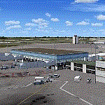
New setup of another airport I came across in one of my virtual flights. It is located 06 miles SW of Cedar Rapids, Iowa.
| Filename: | KCID_Eastern_Iowa_Airport_USA.zip |
| License: | Freeware |
| Added: | 27th April 2018, 00:30:49 |
| Downloads: | 874 |
| Author: | Tim van Ringen |
| Size: | 3.03 MB |
| Category: Flight Simulator X - Scenery | |
| PABE - Bethel Airport - Alaska, USA |
|
Images related to this file:
File Description:
Bethel Airport is a state owned, public use airport located three nautical miles (6 km) southwest of the central business district of Bethel.
Construction began September 21, 1941, and the airfield was activated July 4, 1942; it is also known as Bethel Air Base. It was used by Air Transport Command as auxiliary airfield for Lend-Lease aircraft being flown to Siberia. The facility was transferred to Eleventh Air Force, then to Alaskan Air Command in 1945; it became the joint-use Bethel Airport. It was used for construction of AC&W Bethel Air Force Station in mid 1950s. Full jurisdiction was turned over to Alaska Government in 1958.
Added and adjusted aprons and buildings. Also added additional parking. Added runway 1R/19L.Re-numbered runways to conform with AirNav data.
Created with Airport Design Editor 9x by ScruffyDuck Software using current FAA documentation and Google Earth measurements, this package offers a replacement for FSX's stock airport. All these enhancements are as close to the real airport as I can get with stock library objects and custom buildings.
| Filename: | PABE__Bethel_Airport__Alaska_USA.zip |
| License: | Freeware |
| Added: | 5th December 2014, 13:35:35 |
| Downloads: | 991 |
| Author: | Wayne Roberts |
| Size: | 94.58 KB |
| Category: Flight Simulator X - Scenery | |
| 6I2 - Lebanon-Springfield Airport - Kentucky, USA [FreeMeshX - USA-optimized] |
|
Images related to this file:
File Description:
Lebanon-Springfield Airport (FAA LID: 6I2), a public use airport in Washington County, Kentucky (KY), USA. It is located three nautical miles (6 km) south of Springfield in Washington County) and north of Lebanon (in Marion County). The airport is owned by Marion and Washington Counties. The scenery contains seasonal ground textures for winter, spring, summer, autumn and night; autogen and default scenery objects of FSX plus a modified AFCAD file. Tested with FSX: SE on Windows 10. Version 1.1 contains fixes for the terrain aswell as corrected scenery objects.
** Do not use this version with the default mesh; use 6I2_NO_FMX.zip instead **
By Peregrine Simulations
| Filename: | 6I2__LebanonSpringfield_Airport__Kentucky_USA_Free.zip |
| License: | Freeware, limited distribution |
| Added: | 21st February 2018, 23:36:13 |
| Downloads: | 414 |
| Author: | Peregrine Simulations |
| Size: | 104.1 MB |
| Category: Flight Simulator X - Aircraft Repaints, Textures and Modifications | |
| Evergreen International Boeing 747-400F (SCD) v3 |
|
Images related to this file:
File Description:
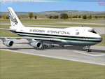
This is an update to the FSX repaint and represents the PMDG 747-400F Queen of the Skies and the -400 variant for Evergreen International (N491EV).
This fixes a minor defect on the starboard winglet (logo orientation). The aircraft was hand painted using the PMDG paintkit and features DDS DXT5 textures and updated night textures which increase the illumination of the fuselage and tail at night.
PMDG 747-400 for FSX required. See readme for important installation instructions and enjoy the repaint.
| Filename: | Evergreen_International_Boeing_747400F_SCD_v3.zip |
| License: | Freeware |
| Added: | 25th February 2013, 07:16:21 |
| Downloads: | 280 |
| Author: | Mark Aldridge |
| Size: | 1.31 MB |
| Category: Flight Simulator X - Scenery | |
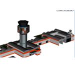
| Imam Khomeini Intl. Airport 2015 (v1.0) |
|
Images related to this file:
File Description:
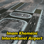
Imam Khomeini International Airport (IATA: IKA, ICAO: OIIE) is the main international airport of Iran, located 30 kilometers (19 mi) southwest of the city of Tehran, near the localities of Robat-Karim and Eslamshahr, on a 13,500-hectare (135 km2) site.
It was designed to replace Mehrabad International Airport, which is in the west of the city, now inside the city boundaries.
The airport was originally designated as Ahmadabad but was later renamed to "Imam Khomeini International Airport".
This package contains "Imam Khomeini International Airport" photoreal scenery based on VE satellites images with LOD19 quality.
| Filename: | Imam_Khomeini_Intl_Airport_2015_v10.zip |
| License: | Freeware, limited distribution |
| Added: | 28th June 2015, 23:54:13 |
| Downloads: | 6,963 |
| Author: | Khashayar Talebzadeh |
| Size: | 227.18 MB |
| Category: Flight Simulator X - Scenery | |
| GVAC AmiÂlcar Cabral International Airport |
|
Images related to this file:
File Description:
AmÃlcar Cabral International Airport (IATA: SID, ICAO: GVAC), also known as Sal International Airport or AmiÂlcar Cabral Airport, is the principal international airport of Cape Verde. The airport is named after the revolutionary leader AmiÂlcar Cabral.
It is located 2 km (1.3 miles) west-southwest from Espargos on Sal Island. Until September 2005, it was the only airport in Cape Verde to serve international flights. (Cape Verde's other international airports are near Praia on Santiago Island,
on São Vicente near the capital of Mindelo and on Boavista.)
| Filename: | GVAC_Amilcar_Cabral_International_Airport.zip |
| License: | Freeware |
| Added: | 24th August 2011, 12:57:05 |
| Downloads: | 6,706 |
| Author: | Miguel Diaz |
| Size: | 29.89 MB |
| Category: Flight Simulator X - Aircraft Repaints, Textures and Modifications | |
| Cessna C172R Skyhawk (C-GBAF) |
|
Images related to this file:
File Description:
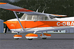
This is a repaint for the superb A2A Simulations Cessna 172R. This repaint is real yet semi-fictional; the real aircraft this paint is based on is a 172K, s/n: 17257297, manufactured in 1969. The real aircraft makes it's home at CYKM Kincardine Municipal Airport in Ontario.
| Filename: | Cessna_C172R_Skyhawk_CGBAF.zip |
| License: | Freeware, limited distribution |
| Added: | 24th September 2013, 14:20:04 |
| Downloads: | 537 |
| Author: | Jim Stewart |
| Size: | 11.08 MB |
| Category: Flight Simulator X - Scenery | |
| VOTR Tiruchirappalli International Airport V1 |
|
File Description:
Tiruchirappalli International Airport (IATA: TRZ, ICAO: VOTR) is an international airport serving Tiruchirapalli in the state of Tamil Nadu, India. Compatibility - FSX & P3D
| Filename: | VOTR_Tiruchirappalli_International_Airport__V1.zip |
| License: | Freeware |
| Added: | 24th November 2017, 17:23:15 |
| Downloads: | 850 |
| Author: | Sachin Gnth |
| Size: | 330.27 KB |
© 2001-2026 AVSIM Online
All Rights Reserved
Privacy Policy |