
Where Flight Simulation Enthusiasts Gather from Around the World!
AVSIM Library - Search Results

| Category: Flight Simulator X - Utilities | |
| Intelligence Cabin Announcements (ICA) V 1.1 Update |

|
File Description:
This File is an update for ica_v_1.0.zip.(download avsim) Previous installation is required!!
Unzip in your Flight Simulator X modules directory and overwrite previous version (announcement.lua).
What does it do?
Fix for double sounds in turbulence situations e.g turbulence announcement and climb announcement at the same time.
Fix for turbulence minimum length to 90 seconds.
While turbulence no other announcement will play now.
| Filename: | Intelligence_Cabin_Announcements_ICA_V_11_Update.zip |
| License: | Freeware |
| Added: | 1st July 2011, 22:09:23 |
| Downloads: | 2,190 |
| Author: | Rainer Kunst |
| Size: | 3.95 KB |
| Category: Flight Simulator X - Aircraft Repaints, Textures and Modifications | |
| Republic of Singapore Air Force, C-130 E |
|
File Description:
This repaint depicts a Republic of Singapapore Air Force C-130E. It is 100% ACE compliant and requires Captain Sims payware "C-130 X-periance" or Justflights "C-130 Hercules" packages. Any comments welcome via my email address. Future updates and/or fixes please visit us at www.mcphatstudios.net. Happy flying and enjoy the textures. This repaint has been optimized for FSX with DDS textures.
| Filename: | Republic_of_Singapore_Air_Force_C130_E.zip |
| License: | Freeware |
| Added: | 11th December 2008, 12:41:10 |
| Downloads: | 620 |
| Author: | Captain Sim & David Sweetman / McPhat Studios |
| Size: | 2.61 MB |
| Category: Flight Simulator X - Aircraft Repaints, Textures and Modifications | |
| Gulfstream G550 | VQ-BGN |
|
Images related to this file:
File Description:

FSX / FS2004 Gulfstream G550 - VQ-BGN. This aircraft was used to ferry the UK's X-Factor judges during the competition in 2009. Painted in HD 32-bit textures and resized to 2048x2048, for use with the HTAI G550 included. Can be used as AI Traffic and is flyable in FS, FDE tweaked to fix fuel and geometry. Used default Lear 45 sounds and CRJ-700 panel.
| Filename: | Gulfstream_G550__VQBGN.zip |
| License: | Freeware |
| Added: | 15th January 2010, 20:31:29 |
| Downloads: | 1,662 |
| Author: | Guy Dutton |
| Size: | 4.2 MB |
| Category: Flight Simulator X - Sounds | |
| Fuel pump noise |
|
File Description:
This file allows to easily replace the nuclear central default fuel pump noise in FS X with much more realistic, softer noise.
I found it absolutely necessary when simming small GA aircraft but I am confident it's even more real for bigger planes where pilots are far from engines, and default FSX fuel pump noise would be enough to declare an emergency and land asap! ;-)
| Filename: | Fuel_pump_noise.zip |
| License: | Freeware |
| Added: | 26th August 2008, 13:36:48 |
| Downloads: | 6,592 |
| Author: | Pierre Baron |
| Size: | 375 KB |
| Category: Flight Simulator X - Scenery | |
| OLBAX V1.0 (Rafik Hariri / Beirut International Airport) |
|
Images related to this file:
File Description:

OLBAX V1.0 is the latest edition of Rafik Hariri International Airport, Beirut / Lebanon for FSX by Lebor Simulations. OLBAX V1.0 features a photorealistic ground layout courtesy of Bureau Stephan, detailed and accurate terminal, buildings and hangars as well as static 3D objects. Jad Abizeid worked on this scenery for almost 4 years.
This scenery requires: Lebanon Terrain X v1.5 by Lebor Simulations
| Filename: | OLBAX_V10_Rafik_Hariri__Beirut_International_Airpo.zip |
| License: | Freeware |
| Added: | 4th February 2013, 02:37:56 |
| Downloads: | 15,528 |
| Author: | Lebor Simulations (Jad Abizeid, Michel Karam) |
| Size: | 130.93 MB |
| Category: Flight Simulator X - Scenery | |
| OIIE - Imam Khomeini International Airport |
|
Images related to this file:
File Description:
The list of what has been added. Landclass, new control tower, big hangars in the airport, parking for cars, taxiway signs, apron lights, Complete and accurate taxiway and runway details, create all freeways and moving cars in freeways.(Google Earth pictures), moving cars in some sreets. Compatible with standard-AI traffic and AI-Traffic Add-ons (for example MyTraffic X) and some other modifications has been made.
| Filename: | OIIE__Imam_Khomeini_International_Airport.zip |
| License: | Freeware |
| Added: | 14th January 2013, 22:06:14 |
| Downloads: | 3,467 |
| Author: | Meysam Goloumjani |
| Size: | 11.34 MB |
| Category: Flight Simulator X - Utilities | |
| FS Earth 5.0 for Google Earth |
|
File Description:
This program acts as an interface between Flight Simulator X and Google Earth, letting to follow a flight in real time, over the satellite images generated by Google Earth. Flights can be saved, and many options are available for fine tuning the performance, as well as the map's style (zoom, tilt, orientation). Works on a single computer running FSX and Google Earth all together or, for best experience, can be used on two networked computers running respectively FSX (master) and Google Earth (slave). AI and Multiplayer traffic is also displayed in Google Earth, with course prediction and other information. Requires Flight Simulator X and Google Earth. The program running in trial mode works only around Anchorage, Alaska, (PANC / ANC) for a maximum of five minutes per flight session. Version 5.0 has improved compatibility with latest releases of Google Earth and several additional improvements. A version for FS2004 is available also.
| Filename: | FS_Earth_50_for_Google_Earth.zip |
| License: | Shareware, time limited |
| Added: | 19th July 2007, 00:46:27 |
| Downloads: | 1,104 |
| Author: | Luciano Napolitano |
| Size: | 2.44 MB |
| Category: Flight Simulator X - AFCAD Files | |
| PASD - Sand Point, Alaska |
|
Images related to this file:
File Description:
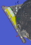
The airport of Sand Point (PASD) has been extended since Microsoft has modeled it and even after the upgrade through Scenery Solution's Ultimate Terrain X Alaska has been produced. This AFCAD is built on the UTX version of the airport and is intended to be used in this environment only.
The file considers the extended runway, VASI4 at both ends with 3.6 deg glideslope and the necessary new water-polygon. Due to the specific coastline bitmaps used by UTX I had to change to Microsoft's default ones being accessible through the wonderful tool Airport Design Editor X. Some additional landclass in the airport's vicinity and three (default) buildings close to the apron are completing the changes. I did not touch the easterly landing stage (or whatever it could have been) even if Google suggests that it disappeared meanwhile except some remaining piles in the water - it's just looking nice. ;-)
| Filename: | PASD__Sand_Point_Alaska.zip |
| License: | Freeware |
| Added: | 17th October 2013, 18:55:00 |
| Downloads: | 377 |
| Author: | Axel Birsul |
| Size: | 646.25 KB |
| Category: Flight Simulator X - Utilities | |
| FS Earth 5.2 for Google Earth and FSX |
|
Images related to this file:
File Description:

This program acts as a link between Flight Simulator X and Google Earth, letting to follow a flight in real time, over the satellite images generated by Google Earth. Flights can be saved, and many options are available for fine tuning the performance, as well as the map's style (zoom, tilt, orientation). Works on a single computer running FSX and Google Earth all together or, for best experience, can be used on two networked computers running respectively FSX (master) and Google Earth (slave). AI and Multiplayer traffic is also displayed in Google Earth, with course prediction and other information. Requires Flight Simulator X and Google Earth. The program running in trial mode works only around Anchorage, Alaska, (PANC / ANC) for a maximum of five minutes per flight session. Version 5.2 has new aircraft icons & labels and improves the compatibility with Windows Vista. A version for FS2004 is available also.
| Filename: | FS_Earth_52_for_Google_Earth_and_FSX.zip |
| License: | Shareware, time limited |
| Added: | 3rd May 2010, 07:38:23 |
| Downloads: | 2,701 |
| Author: | Luciano Napolitano |
| Size: | 3.46 MB |
| Category: Flight Simulator X - Utilities | |
| FS Earth 4.2 for Google Earth |
|
File Description:
This program acts as an interface between Flight Simulator X and Google Earth, letting to follow a flight in real time, over the satellite images generated by Google Earth. Flights can be saved, and many options are available for fine tuning the performance, as well as the map's style (zoom, tilt, orientation). Works on a single computer running FSX and Google Earth all together or, for best experience, can be used on two networked computers running respectively FSX (master) and Google Earth (slave). AI and Multiplayer traffic is also displayed in Google Earth, with course prediction and other information. Requires Flight Simulator X and Google Earth. The program running in trial mode works only around Anchorage, Alaska, (PANC / ANC) for a maximum of five minutes per flight session. Version 4.2 has improved compatibility with Windows Vista and minor bug fixes. A version for FS2004 is available also. By Luciano Napolitano.
| Filename: | FS_Earth_42_for_Google_Earth.zip |
| License: | Shareware, time limited |
| Added: | 9th March 2007, 13:39:05 |
| Downloads: | 2,213 |
| Author: | Luciano Napolitano |
| Size: | 2.44 MB |
© 2001-2026 AVSIM Online
All Rights Reserved
Privacy Policy |