
Where Flight Simulation Enthusiasts Gather from Around the World!
AVSIM Library - Search Results

| Category: Flight Simulator X - Scenery | |
| Australian Offshore Oil & Gas Platforms |

|
Images related to this file:
File Description:

60 helicopter or VTOL land-able Oil rigs that are in current operation around Australia in 2016. Each Rig is GPS mapped for the in-sim GPS/flight planning and 3rd party nav/flight planning software ie: Flightsim Commander or Plan G. Majority of the Rigs contain wildlife around the platform. Google Earth KML include. Zip file contains exculdes to remove the oil pumps supplied by FTX for their AU release and instructions on how to deactivate the older rig locations in OZx v >3. Visit Ozx for more Australasian scenery. Tested in P3D.
| Filename: | Australian_Offshore_Oil__Gas_Platforms.zip |
| License: | Freeware |
| Added: | 19th February 2016, 09:21:57 |
| Downloads: | 799 |
| Author: | Matt Levi |
| Size: | 187.22 KB |
| Category: Flight Simulator X - Scenery | |
| Airport update for Phoenix Sky Harbor Intl (KPHX), Arizona, USA |
|
Images related to this file:
File Description:
This airport update is for Phoenix Sky Harbor Intl airport and made only for FSX users, not made or suitable for use in P3D: The new terminal 3 now added and the gates correctly numbered for it, terminal 2 demolished, assigned parking now updated as per their website where possible, extra fuel trucks, taxiways and taxi signs updated to the latest charts, helipad, support vehicle roads rebuilt and many other scenery improvements and objects added, airport views are from inside the control tower (when in tower view) please view the readme before installation
| Filename: | Airport_update_for_Phoenix_Sky_Harbor_Intl_KPHX_Ar.zip |
| License: | Freeware, limited distribution |
| Added: | 22nd December 2021, 00:22:37 |
| Downloads: | 44,632 |
| Author: | Ray Smith |
| Size: | 3.5 MB |
| Category: Flight Simulator X - Scenery | |
| Hong Kong Intl Airport (VHHH) China |
|
Images related to this file:
File Description:
This is a reasonably accurate and up-to-date version for Chek Lap Kok Airport and made only for FSX users, do not use in P3D: The new Midfield Terminal now updated which includes 3 gates for the A380, assigned parking where possible with extra parking, Cargo expansion area and buildings updated, taxiways and taxi signs updated to the latest charts, extra fuel trucks, support vehicle roads rebuilt and many other scenery objects and improvements added, airport views are from inside the control tower (when in tower view) please view the readme before installation.
| Filename: | Hong_Kong_Intl_Airport_VHHH_China.zip |
| License: | Freeware, limited distribution |
| Added: | 22nd April 2020, 17:40:35 |
| Downloads: | 47,674 |
| Author: | Ray Smith |
| Size: | 2.29 MB |
| Category: Flight Simulator X - Aircraft Repaints, Textures and Modifications | |
| FSX/P3D TWA 707-331C Cargojet 1976 |
|
Images related to this file:
File Description:
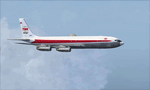
This is a repaint of the 707-300C in TWA Cargojet 'Star Stream' colors. The payware 707-300 with the 707-300C extension by Captain Sim is needed for this repaint. TWA N15711 was a 707-300C. It was mainly used as a cargo freighter by TWA. It was purchased new in June 1968, and after 11 years of service, it was sold to Pakistan International Airlines in May 1979. Textures are 32bit DDS. This repaint was tested FSX-SE. It should work on FSX & P3D v1-3.
| Filename: | FSXP3D_TWA_707331C_Cargojet_1976.zip |
| License: | Freeware |
| Added: | 27th November 2019, 18:56:57 |
| Downloads: | 126 |
| Author: | Ted Giana |
| Size: | 16.8 MB |
| Category: Flight Simulator X - Aircraft Repaints, Textures and Modifications | |
| North American Rockwell OV-10 Bronco (N524NA) NASA |
|
Images related to this file:
File Description:
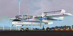
This folder contains a repaint for the Aerosoft OV-10 Bronco for FSX. It represents one of the aircraft formerly operated by NASA, N524NA, which has been based at Langley Research Center in Hampton, VA since Sept. 3, 1991. This aircraft is formerly USAF serial 67-14687 and was last assigned to the 507th Tactical Air Control Wing at Shaw AFB. Repaint by Jan Kees Blom, based on the repaint kit by Aerosoft. I did this paint for the OV-10 CDF model, without the attachment winglets, though the original does have them.
| Filename: | North_American_Rockwell_OV10_Bronco_N524NA_NASA.zip |
| License: | Freeware |
| Added: | 14th July 2018, 17:41:05 |
| Downloads: | 195 |
| Author: | Jan Kees Blom |
| Size: | 9.04 MB |
| Category: Flight Simulator X - Scenery | |
| KHAF - Half Moon Bay Airport - San Mateo County, California - USA |
|
Images related to this file:
File Description:
FSX Scenery - Half Moon Bay Airport (IATA: HAF, ICAO: KHAF, FAA LID: HAF) is a county-owned public use airport in San Mateo County, California, United States. It is located five nautical miles (9 km) northwest of the central business district of Half Moon Bay, California. The airport is on the Pacific Coast, south of San Francisco. The Half Moon Bay Airport is located approximately 20 miles south of San Francisco. It was constructed by the California State Highway Department for the U.S. Army in 1942 as an auxiliary airfield for Salinas Army Air Base. Following the end of World War II, San Mateo County acquired the airport from the Navy in 1947. The airport has served a variety of roles over the years and is currently an important business, transportation and emergency service asset to the community. For your flying pleasure by John B. Loney, Jr.
| Filename: | KHAF__Half_Moon_Bay_Airport__San_Mateo_County_Cali.zip |
| License: | Freeware, limited distribution |
| Added: | 5th August 2015, 18:57:47 |
| Downloads: | 917 |
| Author: | John B. Loney, Jr. |
| Size: | 10.69 MB |
| Category: Flight Simulator X - Scenery | |
| Hawes Aerial Operations Facility |
|
Images related to this file:
File Description:

Hawes Aerial Operations Facility is a reimagined version of an abandoned World War II auxiliary airstrip formerly known as Hawes AAF Aux #1. It was built in the mojave desert, just east of Edwards AFB (then Muroc AAF) during WWII as one of 4 satellite fields for Victorville AAF. After the war, Hawes as used as a private civilian airfield until it's closure in the early 1960's. It is now reborn in FSX as a UAV base by Nevada Systems. Due to it's location in the Mojave desert and the presence of many thermals in FSX, it was also used in production of the Aeroworks ARX-1 civilian glider concept. This scenery uses many custom macros as well as default macros from the Acceleration Expansion Pack, which is required for best performance. Scenery and custom macros by Joshua B. Nyhus and Jason L. Terry
| Filename: | Hawes_Aerial_Operations_Facility.zip |
| License: | Freeware |
| Added: | 7th December 2012, 15:58:27 |
| Downloads: | 540 |
| Author: | Jason L Terry and Josh Nyhus |
| Size: | 5.91 MB |
| Category: Flight Simulator X - Original Aircraft | |
| Heinkel P-1079A Jet Nightfighter |
|
Images related to this file:
File Description:
Heinkel P-1079, a new twin-jet fighter project of the Heinkel Aircraft Construction Corp. was designed in five variations, all under the same designation.
The first of these advanced designs, the Heinkel P-1078A was basically developed as a two-seated nightfighter. The pilot and the gunner/navigator were sitting in tandem position. The wings were swept back 35 degrees, mounted to mid-fuselage. The tail had a V-shaped rudder. The armament were three Rheinmetall-Borsig MK 108 30mm cannons in the nose and 24 R4-M 'Orkan' high explosive rockets on two racks mounted under the wings. Another feature of armament was the so-called 'schraege musik' with four upward-firing 20 mm Mauser MG 151/20 autocannons, mounted in the back of the aircraft. Therefore, the nightfighter had to approach and attack bombers from below, guided into position by commands from the navigator.
The aircraft should be equipped with the new FUG 228 radar unit. This sophisticated radar would have empowered the aircraft with an almost all-weather ability.
The engines were located in the wing roots. This version should be fitted with two Junkers Jumo 004D turbojet engines with two-stage fuel injector, each with 8.8 kN of power.
The Max. speed was about Mach 0.89 = 950kph, the range about 1079.22nm = 1241.9 sm = 2000 km and the max. Service Ceiling up to 51,000 ft = 15,545m
Flyable in FS2004 and FSX
| Filename: | Heinkel_P1079A_Jet_Nightfighter.zip |
| License: | Freeware |
| Added: | 3rd June 2012, 19:56:05 |
| Downloads: | 1,000 |
| Author: | Andreas Becker |
| Size: | 21.43 MB |
| Category: Flight Simulator X - Scenery | |
| RAF Oulton - Norfolk, England |
|
File Description:
I did this scenery for a gentlemen in Canada whose father served at the station during the war I've lost his details but hope he'll pick the scenery up when he searches on line.
RAF Oulton is a former Royal Air Force Satellite airfield located 3 miles (4.8 km) west of Aylsham, Norfolk and 12.5 miles (20.1 km) northwest of Norwich, Norfolk, England.
The airfield was built over 1939 and 1940 as a bomber airfield with T2 type hangars and grass runways, the facility operating as a satellite airfield of nearby RAF Horsham St. Faith between July 1940 and September 1942 after which it operated as a satellite airfield of RAF Swanton Morley.
In September 1943 Oulton was transferred from 2 Group to 3 Group and closed to flying for re-construction as a heavy bomber base with concrete runways, taxiways and parking areas. The work was completed in April 1944 and the airfield transferred to No. 100 Group RAF. Flying operations ceased at the end of July 1945, after which it was taken over by RAF Maintenance Command which used it to store de Havilland Mosquitos until November 1947.
Third Party add-on's will be required to gain the best effect - see the readme file.
| Filename: | RAF_Oulton___Norfolk_England.zip |
| License: | Freeware |
| Added: | 18th November 2015, 14:08:12 |
| Downloads: | 237 |
| Author: | Terry Boissel |
| Size: | 17.25 KB |
| Category: Flight Simulator X - Panels | |
| F-111 Aardvark HUD - Navigation/Situation awareness cockpit with RADAR |
|
Images related to this file:
File Description:
FSX Alphasim F-111 Aardvark HUD. Navigation/Situation awareness cockpit.
REVISION 4. UPGRADE. COMPLETE PACKAGE. Adds upgraded dual role air-to-air ground mapping RADAR with target lock up and script on radar and HUD to enable precise intercepts in all weather day or night and new Sound. Massive amount of digital data.
Must have ALPHASIM F-111 Aardvark to build up this complete and separate F-111. Exceptional capability cockpit Comprising:
-Pilot, WSO and virtual panels;
-3 MFD with 19 selectable pages of data;
-NEW RADAR and 3 GPS type moving maps;
-16 Nearest airports page with full Citynames and ICAO entry capable displays in HUD;
-Clipboard, autopilot;
-Autothrottle and TFR;
-Enhanced HUD is selectable in all views including 10 camera views;
-All data clearly readable size;
-Aircraft carrier capable;
-Effects: bombs, missiles, flares, dump and burn, exhaust trail;
-Detailed REVISED 48 pge Flight Manual plus docs folder.
Configuration ensures crisp and extremely precise controlled flight even down to
10 ft AGL. This panel will set a new benchmark of the amount and type of
data provided and its presentation. Possibly the best pilots' aircraft ever.
Simple Panel replacement if previous version already installed.
By Karol Chlebowski.
| Filename: | F111_Aardvark_HUD__NavigationSituation_awareness_c.zip |
| License: | Check within download |
| Added: | 31st December 2009, 03:09:04 |
| Downloads: | 1,072 |
| Author: | Karol Chlebowski |
| Size: | 35.61 MB |


© 2001-2026 AVSIM Online
All Rights Reserved
Privacy Policy |