
Where Flight Simulation Enthusiasts Gather from Around the World!
AVSIM Library - Search Results

| Category: Flight Simulator X - AFCAD Files | |
| ZSGS - Zhuhai Janwan Airport - Zhuhai, China |

|
File Description:
The Zhuhai Sanzao airport (ZGSD/ZUH, China), close to Macao, was built on request of someone who found it included in the FMC of PMDGs 737NGX, but missed in FSX. I used ADE and the Google based old version 2 of Plan-G (thanks to both authors) and some charts being available in the internet. However, it is equipped with standard buildings which are roughly adapted to the real dimensions well. Lighting, windsocks, taxisigns and moving jetways. Of course I added both ILS as well. There is a big exhibition apron on the airport which is modeled but blocked for AI traffic. You will see the lines of the taxiways nevertheless. The latest temporary chart (Nov 2012) shows a third apron which is not realised and I'm not planning to do so (obviously the whole site is still under construction).
As being built on a FSX island (which is now a peninsula) and default coast lines not fitting to the real position of the airport (Rwy05 was hanging in the water) I decided to compromise in a way that I corrected the area in the vicinity of the airport but respected the remaining part as it was in the default scenery. The attached pictures should give an impression even if I'm not using the pure default scenery. Therefore this little patch should be compatible to advanced mesh sceneries.
| Filename: | ZSGS___Zhuhai_Janwan_Airport__Zhuhai_China.zip |
| License: | Freeware |
| Added: | 2nd May 2013, 07:56:18 |
| Downloads: | 688 |
| Author: | Axel Birsul |
| Size: | 614.11 KB |
| Category: Flight Simulator X - Scenery | |
| California Central Coast Scenery for FSX with Megascenery Earth (Default Mesh Terrain) |
|
Images related to this file:
File Description:
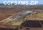
Revised 1/7/10 for upload to Avsim.COM. CCFSXMSFix is incorporated so not required.
This is an earlier version of CCC Megascenery Earth scenery that doesn't require FSGenesis Mesh Terrain. See CCFSXMSG.ZIP for the FSGenesis Mesh version.
This scenery covers the California coastal region from N36���°10' (Coalinga) to N34���°25' (Santa Barbara) and from the coast East to W119���°40'. It is a version of my previous California Central Coast scenery redesigned and expanded to work with MegaScenery Earth from PC Aviator Inc. Many airstrips in the area covered by this scenery have been added or enhanced for a total of 27 airports/airstrips in the area. Several areas of interest such as the Santa Barbara marina, Morro Bay, etc. are also included for a total of 41 points of interest. All airports/airstrips and related structures have been adjusted and realigned to conform to actual positions and dimensions as indicated by the MegaScenery satellite textures. In addition, there are 6 invisible water runways for use by AI floatplane traffic. MegaScenery California-13, -14 and -15 are required for this scenery to make sense. I also used California-12, -28 and -29 when constructing the scenery but they could be considered optional.
| Filename: | California_Central_Coast_Scenery_for_FSX_with_Mega.zip |
| License: | Freeware |
| Added: | 7th January 2010, 21:28:45 |
| Downloads: | 1,560 |
| Author: | Al Wheeler |
| Size: | 8.12 MB |
| Category: Flight Simulator X - Utilities | |
| HUD Parameters for FSX |
|
Images related to this file:
File Description:
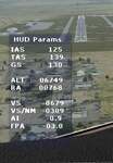
HUD_Parameters.lua is a Lua script that displays flight parameters in a small text window that pops up when the script is selected by an assigned key or button if the aircraft is in the air.
Parameters displayed are:
• Indicated Airspeed (IAS. Kts)
• True Airspeed (TAS, Kts)
• Ground Speed (GS, Kts)
• Mach# (when above a user settable altitude, currently 25000ft)
• Altitude (ALT, ft)
• Radio Altitude (RA, ft)
• Vertical Speed (VS, ft/min)
• Vertical Speed per Nautical Mile (VS/NM, ft/NM)
• Attitude Indicator pitch (AI, degrees)
• Flight Path Angle (FPA, degrees)
The top of the script contains user settable values for the size and location of the display, the altitude above which the a/c Mach# will be displayed (default is 25000ft), the data update interval in milliseconds (default is 2000),
and whether or not data is to be logged in HUD_Parameters.log (default is 0, off). These values can be set using a text editor like NotePad.
A registered copy of FSUIPC is required to execute the Lua script. Simply copy the script to the Modules folder of FSX and use FSUIPC4 to assign a key, button or switch to toggle the script on and off.
The script turns off if the aircraft is on the ground.
Al Klayton
| Filename: | HUD_Parameters_for_FSX.zip |
| License: | Freeware |
| Added: | 29th July 2017, 07:15:25 |
| Downloads: | 475 |
| Author: | Al Klayton |
| Size: | 16.82 KB |
| Category: Flight Simulator X - Scenery | |
| Mesolonghi Airport - Rio-Antirio Bridge - Greece ** UPDATED VERSION ** |
|
Images related to this file:
File Description:
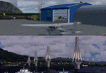
These are actually two sceneries offered in one pack. I started building the small airport of Mesolonghi in Western Greece. When nearing completion, I thought that FS was really missing the big suspension Bridge that connects mainland Greece with Peloponese that was finished in 2004, being the biggest in the world of the fully suspended type. The bridge project turned out bigger than the airport as I ended up doing the typical, Greek-style double ended ferries that served the straights for decades before the bridge and still offer a cheaper and, to some, more relaxing alternative.
Mesolonghi airport is situated 5 kilometers east of the historic city of Mesolonghi and is close to the technical school of fisheries. There is no ICAO code (ZZZZ) so I had to give it the fictional LGME in the sim. A purely day field, it houses the local Aeroclub and ultralight school. due to its small size and hospitable atmoshpere, it is a popular GA pilots destination, receiving also often international arrivals. The runway is asphalt and 800m (2635') in length. No PAPI or VASI are provided. There is no tower service and unicom frequency of 119.7MHz is used by the traffic. Closest controlled airport is Araxos (LGRX), a civil and military field, quite common in Greece, 12.5 nautical miles S-SE. The nearby city of Mesolonghi is famous for its heroic resistance and fall in 1826 during the Greek war of indepence. It is also famous for its fishery production, due to the natural lagoon, formed by the shallow waters.
Features of the Mesolonghi airport scenery include:
- Photoreal area with seasonal variations and watermask.
- Custom hangars and containerised buidings.
- AI default trike performing TnGs (in P3D it will work only if you copy over the FSX trike).
- The technical shool of fisheries on the north side.
- Customized shorelines, to fit with ORBX Global Vector.
- Optional shoreline fix for default scenery.
The Rio-Antirio bridge is located 14.5 nautical miles to the east of the airport. It connects the towns of Rio on the south side and Antirio on the north side. More data on the bridge can be found on Wikipedia.
Features of the Rio-Antirio bridge scenery include:
- Custom bridge model, bump mapped textures with hard platform surface and vehicle traffic.
- Night lighting textures and custom roadlights.
- Photoreal scenery for north and south shores, including hand placed autogen and night textures.
- Custom castle models on north and south sides, with bump mapped textures and night lighting.
- Custom model of the toll post on the north side.
- Custom AI ferry boats with constant shuttle service between Rio and Antirion piers.
- Customized shorelines, to fit with ORBX Global Vector.
- Optional shoreline fix for default scenery.
- Optional HDR optimized photoreal textures.
| Filename: | Mesolonghi_Airport__RioAntirio_Bridge__Greece___UP.zip |
| License: | Freeware |
| Added: | 16th March 2016, 09:15:21 |
| Downloads: | 2,628 |
| Author: | Vassilios Dimoulas |
| Size: | 300.05 MB |
| Category: Flight Simulator X - AFCAD Files | |
| RPLC - Diosdado Macapagal International Clark International, Philippines |
|
File Description:
This Afcad/AFD for RPLC - Diosdad Macapagal International Airport (previously Clark International Airport and Clark AFB) in Angeles City, Pampanga, Philippines was made with ADE V1.37 and is for the default RPLC airport in FSX.
Diosdado Macapagal International Airport is currently a significant low cost carrier and UPS hub for the Philippines and is under development - ultimately intended to replace Ninoy Aquino Airport, Manila (RPLL) as the Premier Gateway to the Philippines. Domestic traffic is currently limited to Cebu Pacific and South East Asian Airlines. The airport handles international traffic - AirAsia, Asiana, Tiger Airways, Hong Kong Express, Hong Kong Airlines and Transglobal - including their recently launched flights to Dhaka and Fujairah - as well as international flights for Asian Spirit to and from Seoul. Cargo use includes a very significant UPS hub, Yangtze River Express, Transglobal and Pacific East Asia Cargo Airlines. Philippine Air Force C-130's are also frequent visitors.
Aprons and taxiways have been changed as needed, additional cargo and airline specific maintenance aprons added, taxiways surfaced correctly, gates and parking spaces coded for airlines and aircraft types using the airport. Many buildings have been changed to be more representative of the real thing. The default airport lacks coding and sees little of the actual traffic coming to RPLC. Use of this file increases traffic and places them where they should park. Tested with WOAI, MAIW's Exotic Alberts Package Philippines Part 1 and custom AI.
| Filename: | RPLC__Diosdado_Macapagal_International_Clark_Inter.zip |
| License: | Freeware |
| Added: | 24th August 2008, 01:18:46 |
| Downloads: | 1,944 |
| Author: | Matthew Brooks |
| Size: | 15.34 KB |
| Category: Flight Simulator X - Scenery | |
| VTSM - Koh Samui |
|
File Description:
Today, after almost half a year of construction, I am presenting my new airport to
youVTSM- Samui Airport in front of .......
since I was already there myself and again no decent freeware scenerywas to be
found for the FSX,
so building it yourself was once again the trend
I tested the airport on another computer - everything works fine
Traffic works, Ai traffic as well as road traffic and ILS approach works. So
have fun in Koh Samui at the airport and the surrounding area .......
The best way to go on a voyage of discovery is with a small plane or helicopter so
that you can do the same
see many details .........
lands at the airport VTSM with an A319 or a Boing 737 larger planes are not there
then allowed to take a helicopter or a small plane and fly over the island
explores the many details ...............
Installation:
Put the folder VTSM - Samui in the folder FSX Addon Scenery and activate
Him......... !
The steps listed below only if you don't have these add-ons yet! !
to be able to see people unzip the supplied folder 3dpeoble_Lib and put
the unzipped folder in your FSX Addon Scenery and activate it
Support:
If you have any problems or questions, please send an email to
[email protected]
now have fun and good luck on your flight LG Jamaica
Demo video at https://youtu.be/dcIkSi03sfg?t=7
| Filename: | VTSM__Koh_Samui.zip |
| License: | Freeware |
| Added: | 5th February 2021, 19:28:51 |
| Downloads: | 785 |
| Author: | Ewald Wagner |
| Size: | 52.16 MB |
| Category: Flight Simulator X - Aircraft Repaints, Textures and Modifications | |
| Airbus A318 FD Special Version V2 |
|
Images related to this file:
File Description:
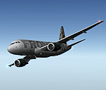
After my initial work on the Project airbus A318 (V1.2) and on the project Airbus A319 (A319 Special Version V2), I present my special version of the Project Airbus A318 Version 2, which includes many improvements and new features.
The instrument panel has been adapted of the Stefan Liebe work, on which I have added many changes. I created a vertical navigation gauge (VNAV gauge) which manages automatically the climb of the aircraft like a FMC (it can be work in several stage), with pre-programmed data according the weight of the aircraft and the altitude. The autopilot is constant MACH, with a transition altitude of 25000ft, thus avoiding the risk of overspeed. The ND will display information page in real time on the flight plan, an information page on the destination airport and display the radar map of the terrain, with AI traffic in real time.
All instruments are active in the VC and 2D panel. The instruments were completed by a multitude of small details. I have improved the autolanding function, with a soft landing (rounded). There is a complete operating manual in PDF format, in English and in French. Of course, TOGA mode and Autobrake mode works. Only compatible with FSX SP2 or Acceleration. See the readme file and the user manual for information and copyright. This version is also a big upgrade on the A318 special version 1.0 and 1.2. This is not an update, but a new aircraft. Francois Dore.
| Filename: | Airbus_A318_FD_Special_Version_V2.zip |
| License: | Freeware, limited distribution |
| Added: | 6th April 2012, 19:59:27 |
| Downloads: | 11,992 |
| Author: | Francois Dore, Project Airbus, Stefan Liebe |
| Size: | 134.71 MB |
| Category: Flight Simulator X - Scenery | |
| Frankfurt Main Airport (EDDF) v8 - Auto installer |
|
Images related to this file:
File Description:
This major update represents EDDF in the July 2015 timeframe.
This version includes further expansion of the Terminal 3 area now in use as extended apron parking, with new J and K ramps for airline, general aviation and cargo aircraft, new apron night lighting, vehicular traffic/roadways as well as support for 70+ airlines coded for AI traffic.
In addition, this update features some brand new taxiways and updated airport navaids including use of the secondary 3.2 degree ILS approach paths for the Northwest runway.
For visual improvements, a new sound wall for the northern perimeter is included along with improvements in landclass to match Orbx FTX Global and inclusion of an optional 200Mb ground photo scenery layer providing even more realism.
Extended compatibility is also provided for P3D and GSX v1.9 (Ground Services for FSX) with the latter providing customized service vehicle parking for each parking position across the whole airport and in some cases, custom GSX pushback operations have been introduced at selected gates. The associated GSX airport .ini file is supplied in this package.
Last of all, more flexibility is delivered. This new scenery now comes supplied with 3 separate .BGL files - the standard .BGL AFCAD file together with the exclusions file ( _CVX) and the separate airport objects file ( _OBJ) so that the airport AFCAD can continue to be updated independently from the airport objects and exclusion files by users wishing to modify the airport layout to their own needs.
Default FSX scenery is required.
Please consult the readme and the comprehensive help manual prior to installation and for more information.
| Filename: | Frankfurt_Main_Airport_EDDF_v8__Auto_installer.zip |
| License: | Freeware |
| Added: | 5th August 2015, 18:50:05 |
| Downloads: | 15,662 |
| Author: | Mark Aldridge |
| Size: | 232.05 MB |
| Category: Flight Simulator X - Scenery | |
| Frankfurt Main Airport (EDDF) v8 - Manual installation |
|
Images related to this file:
File Description:
This major update represents EDDF in the July 2015 timeframe.
This version includes further expansion of the Terminal 3 area now in use as extended apron parking, with new J and K ramps for airline, general aviation and cargo aircraft, new apron night lighting, vehicular traffic/roadways as well as support for 70+ airlines coded for AI traffic.
In addition, this update features some brand new taxiways and updated airport navaids including use of the secondary 3.2 degree ILS approach paths for the Northwest runway.
For visual improvements, a new sound wall for the northern perimeter is included along with improvements in landclass to match Orbx FTX Global and inclusion of an optional 200Mb ground photo scenery layer providing even more realism.
Extended compatibility is also provided for P3D and GSX v1.9 (Ground Services for FSX) with the latter providing customized service vehicle parking for each parking position across the whole airport and in some cases, custom GSX pushback operations have been introduced at selected gates. The associated GSX airport .ini file is supplied in this package.
Last of all, more flexibility is delivered. This new scenery now comes supplied with 3 separate .BGL files - the standard .BGL AFCAD file together with the exclusions file ( _CVX) and the separate airport objects file ( _OBJ) so that the airport AFCAD can continue to be updated independently from the airport objects and exclusion files by users wishing to modify the airport layout to their own needs.
Default FSX scenery is required.
Please consult the readme and the comprehensive help manual prior to installation and for more information.
| Filename: | Frankfurt_Main_Airport_EDDF_v8__Manual_installatio.zip |
| License: | Freeware |
| Added: | 5th August 2015, 18:49:53 |
| Downloads: | 7,205 |
| Author: | Mark Aldridge |
| Size: | 230.24 MB |
| Category: Flight Simulator X - AFCAD Files | |
| Linden Airport (KLDJ), NJ v1.1 |
|
File Description:
Located 01 miles SE of Linden, New Jersey on 188 acres of land, Linden Airport is a public asphalt strip 4137' in length. Numerous changes have been made to this airport to bring it closer to its real-life counterpart including proper non-precision runway markings for R09 while only basic markings are used for R27; The 4-box VASI has been accurately located; the traffic pattern height has been adjusted; All 130 tiedown locations have been accurately placed. RAMP_GA spots are taken by static aircraft (all of which have collision disabled) so they should not be selected unless you want to start inside another aircraft! RAMP_GA_SMALL spots can be occupied by aircraft with wingspans up to 40 feet and RAMP_GA_MEDIUM spots can be occupied by aircraft with wingspans up to 60 feet. There are 4 open hangars labeled as GA_DOCK. The main hangar (NW Parking) can hold aircraft with wingspans up to 60 feet. The three smaller hangars (SW Parking) can hold aircraft with wingspans up to 35 feet. The W Helipad start location will put you in front of the smaller main tarmac hangar within the coned-off section. Fuel is only available by taxiing to a stop in front of either fuel tank to the west of the main tarmac. No AI aircraft will spawn in the SW Parking area.
Scenery constructed with use of satellite images/streetview/aerial photos - the author has not been there in person.
This scenery is meant to be used in conjunction with MegaScenery Earth New York 005. It is not required, but apron use is minimized to allow satellite scenery to show through as much as possible, and objects are placed based on the MSE textures - lack of it may make scenery look out of place.
| Filename: | Linden_Airport_KLDJ_NJ_v11.zip |
| License: | Freeware |
| Added: | 28th June 2011, 00:03:41 |
| Downloads: | 511 |
| Author: | Drew Sikora |
| Size: | 1.23 MB |


© 2001-2026 AVSIM Online
All Rights Reserved
Privacy Policy |