
Where Flight Simulation Enthusiasts Gather from Around the World!
AVSIM Library - Search Results

| Category: Flight Simulator X - Scenery | |
| DL_CVN75.zip |

|
File Description:
Scenery: Carrier Group North sea. Close to the Island of Sylt
The Scenery includes:
- The USS Carrier Harry Truman, CVN 75 with full function as an Airport with ILS approach capability.
- 6 F18-Fighters and a Navy-Heli on the Carrier.
- 2 flying Helicopters over the Carrier.
- 4 Navy-Destroyers escorting the Carrier.
In addition to the Carrier-Group:
- A Oilrig about 30 nm northwest from the Carrier. The Heli-Pat is a landable Platform !!
- 2 moving Destroyer based on a "Boats Traffic Plan" which are moving around the group according to the time schedule in the plan.
| Filename: | DL_CVN75zip.zip |
| License: | Freeware |
| Added: | 3rd October 2008, 01:30:20 |
| Downloads: | 2,075 |
| Author: | Dietmar Loleit |
| Size: | 5.2 MB |
| Category: Flight Simulator X - AFCAD Files | |
| City of Colorado Springs Mun - KCOS - Colorado |
|
File Description:
This airport update was designed with the latest version of ADE (Airport Design Editor) and made only for the default FSX airport: one file with the Crosswind runway activated where all 3 runways will be used for takeoff/landing and one file as the default runway operation: assigned parking with extra parking, ILS added to 35R by ADE, taxiways and taxi signs updated to the latest charts, extra fuel trucks, support vehicle roads rebuilt and many other improvements, airport views are from the roof of the control tower (when in tower view) please view the readme before installation
| Filename: | City_of_Colorado_Springs_Mun__KCOS__Colorado.zip |
| License: | Freeware |
| Added: | 31st October 2011, 08:29:37 |
| Downloads: | 1,807 |
| Author: | Ray Smith |
| Size: | 32.81 KB |
| Category: Flight Simulator X - AFCAD Files | |
| FDMS - Matsapha Airport - Manzini, Swaziland |
|
File Description:
Matsapha Airport (IATA: MTS, ICAO: FDMS) is an airport located near Manzini, a city in Manzini District of Swaziland.
Sikhuphe International Airport was planned to replace it by 2010, with Matsapha being taken over by the army. As of May 2012, Sikhuphe International Airport is still incomplete and no handover date is known. Airport runways were corrected also the aprons and buildings. NOTE ILS runway 07 is out of service at this time and runway 07 approach needs to be 5,000 feet minimum when flying from the west.
This work is dedicated to West Wind Airlines.
| Filename: | FDMS__Matsapha_Airport__Manzini_Swaziland.zip |
| License: | Freeware |
| Added: | 22nd June 2013, 22:18:22 |
| Downloads: | 260 |
| Author: | Anwar Gonzalez |
| Size: | 7.81 KB |
| Category: Flight Simulator X - Scenery | |
| Decimomannu Mil. |
|
Images related to this file:
File Description:
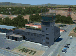
Decimomannu Mil. [Sardinia] Scenery for FSX / P3D also includes 'Capo Frasca' Weapons Range Scenery. 'Deci' [ICAO LIED] for FSX & P3D includes Buildings, Hangars, Gate Guards, Monuments, Ground Equipment, AFCAD, Tower View and Custom Lighting. The scenery includes the 'Pantograph' refuelling system which will automatically refuel your aircraft if you park adjacent to the equipment.
"Capo Frasca" Range Scenery includes Observation Towers, Targets, Radar Equipment and Main Entrance that are modelled as near as possible to the current 'real world' situation. An optional ILS system is included in the AFCAD to assist 'running in' on the two main target areas.
| Filename: | Decimomannu_Mil.zip |
| License: | Freeware |
| Added: | 12th March 2015, 23:29:31 |
| Downloads: | 3,643 |
| Author: | Dave Torkington & Guy Neild |
| Size: | 65.91 MB |
| Category: Flight Simulator X - Scenery | |
| New Chitose Airport (RJCC) Sapporo, Japan |
|
Images related to this file:
File Description:
This airport scenery was made only for FSX: The airport has now been combined with RJCJ so all four runways will be used for takeoff and landing, the new International terminal now included, assigned parking as per their website with extra parking including five gates for the A380 in their correct locations, ILS added to 19L and approach data also updated for the other runways where possible, taxiways and taxi signs updated to the latest charts, extra Fuel trucks and many other scenery improvements, airport views are from inside the control tower (when in tower view) please view the readme before installation
| Filename: | New_Chitose_Airport_RJCC_Sapporo_Japan.zip |
| License: | Freeware, limited distribution |
| Added: | 30th August 2016, 12:32:46 |
| Downloads: | 26,843 |
| Author: | Craig Scott |
| Size: | 1.56 MB |
| Category: Flight Simulator X - Miscellaneous Files | |
| POP "Plans-on-Paper" Nr. 2 |
|
File Description:
Plans on paper is for the real "pure" navigating pilot, no addons, no moving maps and no gps ofcourse ;-) The file contains one single Excell file with an IFR navigation/log form and one or more maps. Just print the plan and map(s), complete it with the "actual" wheather and aircraft details and off you go. You need Excell or another application that read Excell files to be able to read the file and it does some automatic calculation. Nr. 2 is in Norway. Nice Fjorden Approach, no glide scope available and ILS not aligned with RWU heading so good luck
| Filename: | POP_PlansonPaper_Nr_2.zip |
| License: | Freeware |
| Added: | 25th October 2008, 22:16:53 |
| Downloads: | 383 |
| Author: | Arjen de Vries |
| Size: | 187.26 KB |
| Category: Flight Simulator X - Scenery | |
| Pichlingersee - LOW1 |
|
Images related to this file:
File Description:
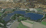
The Pichlingersee (LOW1) is a quarry pond near Linz (LOWL) in Austria (Upperaustria). The ILS approach to the runway 27 cross this lake. The helipad is in possession of Water Rescue Department and was not build on land. It was build "in water".
For the implementation of this area about 500 objects were set by hand from myself. Including not only trees and shrubs, but also signs, park benches, emergency call boxes (gernerated in gmax) etc at there right place. At night it was dark in real, so I does not create night texture. The scenery has 1.5 km ground imagery at 20cm per pixel and vary (hope) with the seasons.
Der Pichlingersee ist ein Baggersee in der Nhe von Linz (LOWL) in sterreich (Obersterreich). Der ILS Anflug auf die Landebahn 27 fhrt genau ber diesen See. Die Hubschrauberplattform gehrt der dortigen Wasserrettung und wurde nicht auf dem Land, sondern in den See hinein gebaut.
Fr die Umsetzung des Areals wurden von mir ber 500 Objekte von Hand gesetzt. Darunter nicht nur Bume und Strucher, sondern ebenso Schilder, Parkbnke, Notrufsulen (in gmax generiert) usw. an ihrem richtigen Platz. Da es dort in der Realitt nachts stockdunkel ist, habe ich auf Nachttexturen verzichtet. Die Szenerie hat eine 1.5 km Bodentextur mit 20cm/px und wechselt (hoffentlich) mit den Jahreszeiten.
| Filename: | Pichlingersee__LOW1.zip |
| License: | Freeware |
| Added: | 9th January 2013, 00:44:19 |
| Downloads: | 1,997 |
| Author: | Oliver Brandl |
| Size: | 54.71 MB |
| Category: Flight Simulator X - Scenery | |
| X2DA - RAF Down Ampney - Gloucestershire, England |
|
File Description:
RAF Down Ampney (ICAO X2DA) was a Royal Air Force station located 1.8 miles (2.9 km) north east of Cricklade, Wiltshire and 3 miles (4.8 km) south west of RAF Fairford, Gloucestershire.
The airfield operated during World War II from February 1944 until February 1947.
Down Ampney was part of a group of 3 airfields with RAF Broadwell and RAF Blakehill Farm dedicated to air transportation.
No. 48 Squadron RAF and No. 271 Squadron RAF flew Douglas Dakotas on major missions. On D-Day they dropped the main elements of the 3rd Parachute Brigade in Normandy as well as towing Airspeed Horsa gliders across the English Channel.
They were also active in Operation Market Garden (Arnhem) and the Rhine crossing.
Source: Wikipedia.
| Filename: | X2DA__RAF_Down_Ampney__Gloucestershire_England.zip |
| License: | Freeware |
| Added: | 16th April 2016, 11:37:35 |
| Downloads: | 148 |
| Author: | Terry Boissel |
| Size: | 1.94 MB |
| Category: Flight Simulator X - Scenery | |
| TACAN Replacements - US Complete |
|
File Description:
By default, all of the TACAN navigational aids present within FSX have the bearing component turned off, so as to properly represent the real world result of tuning in the DME component of a TACAN with a civilian plane. However, this limits their functionality when you wish to use them in conjunction with a plane (generally military) equipped with a representation of a functioning TACAN system.
This download contains 105 fixed/adjusted/changed navigational aids for the United States to represent all currently active TACAN stations. These navigational aids have all had the bearing component turned on, so that they are completely usable for navigation within the sim.
This package completely replaces any previous partial TACAN release for the United States.
| Filename: | TACAN_Replacements__US_Complete.zip |
| License: | Freeware |
| Added: | 17th June 2014, 16:15:09 |
| Downloads: | 1,227 |
| Author: | Jim Stewart |
| Size: | 111.71 KB |
| Category: Flight Simulator X - Aircraft Repaints, Textures and Modifications | |
| "Real World Livery" Embraer EMB-505 Phenom 300 (N900HT) |
|
Images related to this file:
File Description:

This is a very close approximation of a real world Embraer Phenom 300. The home base of N900HT is not known for sure, but is occasionally seen coming and going from Big Bear City airport in Southern California. Daytona Beach, FL is also frequented by this one. Big Bear City is one of those high altitude airports in the mountains West of twentynine Palms and East of LAX and North of Palm Springs. N900HT was delivered in September, 2011 and was featured in a sales video by one of the active private jet dealers in sunny Southern California. You will need to own a copy of the Carenado EMB-505 Phenom 300 for FSX, P3D or FSX:Steam to use this repaint. Enjoy.
| Filename: | Real_World_Livery_Embraer_EMB505_Phenom_300_N900HT.zip |
| License: | Freeware |
| Added: | 29th October 2015, 23:48:38 |
| Downloads: | 1,312 |
| Author: | Ray Marshall |
| Size: | 27.9 MB |
© 2001-2026 AVSIM Online
All Rights Reserved
Privacy Policy |