
Where Flight Simulation Enthusiasts Gather from Around the World!
AVSIM Library - Search Results

| Category: Flight Simulator 2004 - Scenery | |
| Schefferville CYKL & Squaw Lake CSZ9 in Quebec Canada |

|
Images related to this file:
File Description:
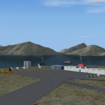
Schefferville is a town in an area of Quebec that is surrounded by Labrador, the border taking an unusual wriggly course instead of the normal Canadian straight line. One has to presume that there was a lot of political negotiation involved. Take a look at Google Earth to see what I mean. The town was established in 1954 (initially at a site a bit north of the present location, and with a different name) to support newly established iron ore mining. To assist with the exploration for further iron ore and the construction of the railway it seems that there was a forced relocation of native population. Although iron ore mining around Schefferville in its current location flourished through the late 1960's these relocated folk were neglected and suffered "destitute poverty". Through the 1970's iron ore mining declined and ceased in Schefferville in 1982, when most of the 4,000 or so non-native residents left. Since the year 2000 there have been moves to reopen mining in the area and production restarted in 2011, the approximate date of this scenery. The main reason why iron ore mining started again in Schefferville as opposed to any other area in Quebec or Labrador is the existing railway, used for ore transportation. There is no road connection and the airport is the only other means of access for the 250(?) town inhabitants. This population figure is somewhat of a guess, and the town inhabitants are largely company officers who change and move in and out as required by their work. Schefferville airport is to the east of the town. It has a single lit asphalt runway that is aligned 18-36 and is 4,975 feet long and 150 feet wide, with PAPI at both ends. Air Inuit flights connect with Kuujjuaq to the north and Sept-Isles to the south with onward connections to all parts of Canada. There are other charter flights for company personnel. The terminal building has been renovated and the photos show just how dilapidated it had become before this was done. I like it. This scenery also includes Squaw Lake, a float base that is used by Air Saguenay. Or was, as the company was closed in 2019 after an accident involving several deaths. The reason for Air Saguenay establishing a float base here was, once again, the railway, which allowed people to reach Schefferville for a reasonable cost. They could then use the float planes for a shorter distance and reasonable price to reach fishing lodges on the lakes to the north. If you find an error email me please, and note that my email address has been changed to rogwens at Gmail dot com.
| Filename: | schefferville_qc.zip |
| License: | Freeware, limited distribution |
| Added: | 1st August 2021, 16:10:32 |
| Downloads: | 116 |
| Author: | Roger Wensley |
| Size: | 17.04 MB |
| Category: Flight Simulator 2004 - Scenery | |
| CYIK -Ivujivik - Hudson Bay, Quebec, Canada Modified V1 |
|
Images related to this file:
File Description:
This modified version installs new taxiway lights and windsocks, and updates the AI. This is a complete version and does not require you to have installed the original. Ivujivik is a village of 350 or so inhabitants at N62 25 W78 on the northeastern corner of Hudson Bay, in northern Quebec. The village does not feature in FS9 but is included in this scenery with approximately the right shape (the coast, even with UT, is not exactly right). The runway is 3,500 feet of gravel 100 feet wide, aligned 08-26.
| Filename: | ivujivik_v1.zip |
| License: | Freeware, limited distribution |
| Added: | 23rd August 2014, 11:26:17 |
| Downloads: | 213 |
| Author: | Roger Wensley |
| Size: | 11.61 MB |
| Category: Flight Simulator 2004 - Scenery | |
| CYZG - Salluit - Hudson Strait, Quebec, Canada, Modified V1 |
|
Images related to this file:
File Description:
This modified version installs new taxiway lights and windsocks, and updates the AI. This is a complete version and does not require you to have installed the original. Salluit is a village of 1,250 or so inhabitants at N 62 W 75 40 on the shore of Sugluk Inlet, which is in northern Quebec off the Hudson Strait. It's name means "Skinny Ones" in Inuit, and refers to a time when there was not enough to eat, which is a rather scary reminder of just how fragile Inuit survival used to be. The airfield runway is 3,510 feet of gravel 100 feet wide aligned 03-21, and is some 740 feet higher than the village on the shoreline.
| Filename: | salluit_v1.zip |
| License: | Freeware, limited distribution |
| Added: | 23rd August 2014, 11:26:53 |
| Downloads: | 250 |
| Author: | Roger Wensley |
| Size: | 11.17 MB |
| Category: Flight Simulator 2004 - Scenery | |
| CYPX - Puvirnituq - Hudson Bay - Quebec, Canada, Modified V1 |
|
Images related to this file:
File Description:
This modified version installs new taxiway lights and windsocks, and the PAPI that has been recently installed at the airport, plus it modifies the AI. This is a complete version and does not require you to have installed the original. A new terminal building was opened in 2013, but as I unfortunately have not been there to take recent photos I am unable to model it, so this scenery is as it was in 2011. Puvirnituq is a village of 1,300 or so inhabitants at N60 W77 on the east shore of Hudson Bay in Quebec. It's name means "Putrid" in Inuit, and there are two different stories about how it got the name. The runway is a very generous 6,300 feet of gravel 148 feet wide aligned 01-19, which should be enough for almost anything.
| Filename: | puvirnituq_v1.zip |
| License: | Freeware, limited distribution |
| Added: | 23rd August 2014, 11:27:59 |
| Downloads: | 227 |
| Author: | Roger Wensley |
| Size: | 11.13 MB |
| Category: Flight Simulator 2004 - Scenery | |
| Repost of St Jovite CSZ3 in Quebec Canada |
|
File Description:
This post is to get rid of an elevation problem I just noticed, and also to supply the revised AFCAD file.
St Jovite is a grass strip in Quebec near the town of St Jovite and Mont Tremblant tourist area. This version is intended for use with Ultimate Terrain, and I made it because I found that the original FS version and the one made by Leon Louis both clashed with Lac Ouimet, and with the float base scenery I had made there. There is no fuel or oil or maintenance available, but the grass runway is in excellent condition. I made one of my first trips from Rockcliffe to St Jovite, and found it a great destination. You probably need Ultimate Terrain for this to work, but it might work without.
| Filename: | stjovite.zip |
| License: | Freeware |
| Added: | 15th February 2009, 15:44:14 |
| Downloads: | 362 |
| Author: | Roger Wensley |
| Size: | 855 KB |
| Category: Flight Simulator 2004 - Scenery | |
| Iles de la Madeleine CYGR in Quebec Canada |
|
Images related to this file:
File Description:
The Iles de la Madeleine are a group of spit islands linked by bridges in the Gulf of St Lawrence. They are east of New Brunswick, north of Cape Breton Island, west of the Island of Newfoundland, and south of the mainland coast of Quebec. On a southwest to northeast axis they are 40 miles in length and the airport CYGR is pretty much at the midpoint of the southern line of islands. Take a look at the overhead from FS9 to see what I mean. CYGR has two runways, one is aligned 08-26 and is just under 4,400 feet long and 150 feet wide with lighting and PAPI at both ends. The second is aligned 16-34 and is 3,600 feet long and 150 feet wide, without lights or PAPI. Both are asphalt. The apron is not huge, and a newish (in 2010) hangar was built with separate access to the 16-34 runway. There are daily flights by Air Canada and Pascan Aviation included in the AI. The AI also includes some boats and a ferry, and I first used these with my Dutch Harbor scenery, so if you have that already.... This scenery also includes Cindy Hook, a small boat harbour just 2 miles southwest of the airport, and the larger harbour at Cap aux Meules a further 3 miles away that accommodates the daily ferry trips, along with fishing boats etc. Also included here is a further addition to the Homer PAHO scenery in the shape of a boat that is included in the Homer Spit harbour. Just add the contents of the scenery folder to the Homer scenery folder of your Homer installation, and the texture folder contents to the Homer texture folder. This is hopefully the last PAHO addition, and again apologies. If you find an error email me please, and note that my email address has been changed to rogwens at Gmail dot com.
| Filename: | iles_de_la_madeleine_qc.zip |
| License: | Freeware, limited distribution |
| Added: | 28th July 2021, 17:02:18 |
| Downloads: | 179 |
| Author: | Roger Wensley |
| Size: | 27.78 MB |
| Category: Flight Simulator 2004 - Scenery | |
| CYSV Canada, New Foundland, Saglek |
|
Images related to this file:
File Description:
This scenery for FS-2004 as much as possible represents Saglek (CYSV), located at the north of New Foundland, Canada according to photographs found on the Web. This scenery is compatible with Mesh de M.Gilles Gauthier. Several originators took part in the design of this scenery: Regis Dassylva, Gerald Allaire, Gilles Gauthier and Jean-Pierre Fillion, all members of Concepteurs Virtual du Quebec.
| Filename: | cysv_reel_2k4.zip |
| License: | Freeware |
| Added: | 31st December 2009, 04:53:29 |
| Downloads: | 650 |
| Author: | Regis Dassylva |
| Size: | 2.37 MB |
| Category: Flight Simulator 2004 - Scenery | |
| Herb's field near highway 417 in Ontario Canada |
|
File Description:
Herb's field is an unlicensed grass strip near a junction and a gas station on highway 417, some twenty miles west of the Ontario/Quebec border. I saw it a while back from the air and forgot about it, then saw it again when I was driving along the highway. Couldn't miss it because of the two red and white checkerboard hangers. So here it is.
| Filename: | herbs.zip |
| License: | Freeware |
| Added: | 2nd August 2007, 00:31:53 |
| Downloads: | 457 |
| Author: | Roger Wensley and Jim Turner |
| Size: | 413 KB |
| Category: Flight Simulator 2004 - Scenery | |
| Air Saguenay floatbase Lac Sebastien CTD3 in Quebec Canada |
|
Images related to this file:
File Description:
This is the first of five sceneries around Lac Saint-Jean in Quebec, Canada, to the west of the St Lawrence River and close to Bagotville air base. Air Saguenay are a mainly float plane company that operates hunting and fishing flights to company-owned outposts in northern Quebec, with a fleet of almost 30 aircraft including 11 de Havilland Otters and 14 Beavers as of the last count. Their HQ float base is on Lac Sebastien, which is 30 miles east of the far larger Lac Saint-Jean. There are screenshots of this scenery and others in the series that follow this post in the Lac Saint-Jean QC folder. This scenery includes in the AI an Air Saguenay turbine Otter on floats, which has been modified to operate as an AI floatplane with a new config file. The ai also includes other GA float planes. There are also planes listed that will be required only for the future posts in this series, and the relevant textures etc will be provided at the date of the posts. Some of the Beaver AI planes will only be available if you already have the aerosoft Beaver installed. There are HTAI planes used as AI in this series, updated by Nick Tselepides, and the float planes for this part of the series are included here, Cessna 185's.
| Filename: | air_saguenay_floatbase_qc.zip |
| License: | Freeware, limited distribution |
| Added: | 4th November 2017, 07:15:09 |
| Downloads: | 289 |
| Author: | Roger Wensley |
| Size: | 12.25 MB |
| Category: Flight Simulator 2004 - Scenery | |
| Canadian and Northern USA Winter Flying |
|
File Description:
This is an expanded version of a previous post a year ago, and stretches from east of Quebec City through Quebec, Ontario, and Manitoba, and now also through Saskatchewan, and into Alberta (past Calgary). There is also a northern area roughly centered on Hudson Bay. The exact coverages are given in the notes. All rivers and lakes within the area will "freeze" and allow ski planes to land, or even wheeled planes come to that. And it is not permanent, when you want to go back to floats just "untick" it in the FS library, and it will melt. The area covered crosses into the US too, down to around 45 degrees north, so that means most of Montana, all of North Dakota, half of Minnesota, and some of Wisconsin, Michigan etc. It seemed silly to stop at the border. Ultimate Terrain is highly recommended, so that there will actually be the right lakes and rivers ready to freeze.
| Filename: | frozen02.zip |
| License: | Freeware |
| Added: | 26th May 2008, 13:24:29 |
| Downloads: | 667 |
| Author: | Roger Wensley |
| Size: | 352 KB |
© 2001-2025 AVSIM Online
All Rights Reserved