
Where Flight Simulation Enthusiasts Gather from Around the World!
AVSIM Library - Search Results

| Category: Flight Simulator 2004 - Scenery | |
| Kanoya Air Field (RJFY) |

|
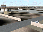
Images related to this file:
File Description:
Kanoya Air Field Japan. A JMSDF facility that is home of the 211 Air Training Squadron and 1st Air Patrol Squadron. Includes FS9 and FSX paints for the AI Sea Hawk by John Young, flight plans and scenery for Kanoya. Please see the readme file for a list of required scenery libraries.
| Filename: | Kanoya_Air_Field_RJFY.zip |
| License: | Freeware |
| Added: | 14th October 2015, 15:40:43 |
| Downloads: | 953 |
| Author: | Brent Newman |
| Size: | 11.02 MB |
| Category: Flight Simulator 2004 - Scenery | |
| FS2004 Scenery PMDY-Midway-Henderson Field AFCAD update |
|
File Description:
FS2004 Scenery PMDY-Midway-Henderson Field AFCAD update
AFCAD Update for FS2004 Scenery for Midway Island 1970 from John Stinstrom.
You need the original files from here:
https://library.avsim.net/download.php?DLID=188019
Please take a look into included Install & Disclaimer file.
If you find a defect please eMail me via as: [email protected].
| Filename: | FS2004_Scenery_PMDYMidwayHenderson_Field_AFCAD_upd.zip |
| License: | Freeware |
| Added: | 1st February 2021, 23:31:21 |
| Downloads: | 433 |
| Author: | Bernd Barsch |
| Size: | 620.31 KB |
| Category: Flight Simulator 2004 - Scenery | |
| Lake Manyara water level modification |
|
Images related to this file:
File Description:
Modified HP file for Lake Manyara. This modification is intended for use with 76m mesh only and lowers the lake level to fit with terrain.
Added files to move and modify HTLM Lake Manyara Airstrip.
| Filename: | Lake_Manyara_water_level_modification.zip |
| License: | Freeware |
| Added: | 25th October 2022, 14:30:48 |
| Downloads: | 64 |
| Author: | John Tennent |
| Size: | 35.75 KB |
| Category: Flight Simulator 2004 - Scenery | |
| Bodega Bay, California Scenery |
|
File Description:
Bodega Bay, California for FS2004
Represents Bodega Bay on the Sonoma coast of California, with due homage to the 1963 Alfred Hitchcock movie, "The Birds" - so it's more artistic than realistic! REQUIRES Lago FSE (payware) and includes local landclass. Lots of eye candy in this one. Please unzip (using folders option) to a temporary folder and follow the instructions carefully).
| Filename: | Bodega_Bay_California_Scenery.zip |
| License: | Freeware |
| Added: | 14th August 2005, 12:07:58 |
| Downloads: | 770 |
| Author: | John Burford |
| Size: | 149.85 KB |
| Category: Flight Simulator 2004 - Scenery | |
| VAKE Kandla/Gandhidham, India |
|
Images related to this file:
File Description:
Googly scenery for VAKE Kandla/Gandhidham - a small domestic airport
in the state of Gujurat, India, for which little other than a runway is
provided in Flight Simulator 2004. These scenery files add taxiways, aprons,
buildings and other airport features, so that you and your "AI" traffic can
land, taxi, park and take off in a realistic manner.
Gandhidham is a small city about 5 miles from the seaport of Kandla, in the
Gulf of Kutch, and was developed in 1950 after the separation of Pakistan and
India left the key port of Karachi in Pakistan. The airport is served by daily
flights using turboprop aircraft of Air Deccan.
The scenery does not purport to be ultra-accurate. Based on high-detail satellite
imagery from Google Earth, the layout is proportionally correct but the added
airport features, such as buildings, are built from default Microsoft objects
and add-on libraries so will not look exactly like the real thing.
You are not obliged to download and install any additional scenery libraries,
but to enjoy this scenery in its entirety, you may wish to. It will work fine,
with or without.
[File re-uploaded at request of AVSIM]
| Filename: | VAKE_KandlaGandhidham_India.zip |
| License: | Freeware |
| Added: | 14th May 2010, 05:11:31 |
| Downloads: | 848 |
| Author: | John Hinson |
| Size: | 67.36 KB |
| Category: Flight Simulator 2004 - Scenery | |
| VAOZ Nashik/Ozar, India |
|
File Description:
Googly scenery for Ozar, a small domestic airport located in Nashik (or
Nasik), 111 miles from Mumbai (Bombay). Nashik is a fast-expanding city in
the Maharashtra state in the Western Ghats located on the western edge of the Deccan
peninsula and is known as the Wine Capital of India or Grape City.
Owing to its close proximity to Mumbai, the airport has not proved popular as
the journey by taxi, bus or rail is not much greater after taking into account
check-in times etc. Air Deccan recently withdrew all flights from Ozar and as
far as I can establish the only airline now serving Ozar is Jagson Airlines,
using Dornier 228 turboprops. There is also a military presence at the east
end of the airport.
Flight Simulator 2004 has only provided a runway at this airport and this scenery
seeks to redress the situation so that you and your "AI" traffic can use the
airport.
The scenery does not purport to be ultra-accurate. Based on high quality
satellite imagery from Google Earth, the layout is proportionally correct but the
added airport features, such as buildings, are built from default Microsoft objects
and add-on libraries so will not look exactly like the real thing.
You are not obliged to download and install any additional scenery libraries,
but to enjoy this scenery in its entirety, you may wish to. It will work fine,
with or without.
| Filename: | VAOZ_NashikOzar_India.zip |
| License: | Freeware |
| Added: | 22nd April 2008, 07:55:32 |
| Downloads: | 737 |
| Author: | John Hinson |
| Size: | 118.11 KB |
| Category: Flight Simulator 2004 - Scenery | |
| WIKD/WIOD Tanjung Pandan/Buluh Tumbang/H.A.S. Hanandjoeddin, Indonesia |
|
File Description:
Googly scenery for WIKD/WIOD Tanjung Pandan/Buluh Tumbang/H.A.S. Hanandjoeddin,
Indonesia, based on Google Earth satellite data. It is a small domestic airport
serving the island of Belitung, located about 17 miles from the main town of the
island - Tandjungpandan. The island produces mainly tin and pepper but there are
some beaches that are generating tourist traffic too.
Flight Simulator 2004 has made no provision for any traffic at this airport and
this scenery seeks to redress the situation. The airport sees daily scheduled
traffic operated by Batavia Air and Sriwijaya Air.
The scenery does not purport to be ultra-accurate. Based on poor quality
satellite imagery from Google Earth, the layout is proportionally correct but the
added airport features, such as buildings, are built from default Microsoft objects
and add-on libraries so will not look exactly like the real thing.
You are not obliged to download and install any additional scenery libraries,
but to enjoy this scenery in its entirety, you may wish to. It will work fine,
with or without.
The ICAO code for this airport has recently changed from WIKD to WIOD. The included
files allow you to either retain the old code or optionally change the airport to
use the new one.
| Filename: | WIKDWIOD_Tanjung_PandanBuluh_TumbangHAS_Hanandjoed.zip |
| License: | Freeware |
| Added: | 22nd February 2008, 09:19:27 |
| Downloads: | 1,772 |
| Author: | John Hinson |
| Size: | 64.96 KB |
| Category: Flight Simulator 2004 - Scenery | |
| Cardington Version 2 |
|
File Description:
Cardington (UK) Airship Station for FS2004 by John McKeon - Version 2 - 17/10/2005
Location correct to VFR photoreal scenery and compatible with default and Golden Wings scenery
The British hub for inter-continental airship travel in 1918-1935 and site of Short Brothers airship factory, which built R31- R38. The facilities are, a conventional grass strip for departure, a 300 ft mooring mast with docking device for arrival, two enormous sheds with pilot-controlled opening doors, static aircraft, vehicles, people, and equipment; refuelling and regassing station, smoking chimney, terminal buildings, repair and maintenance sheds. Package includes carrier operations "rcbp-20.zip" for docking device.
| Filename: | Cardington_Version_2.zip |
| License: | Freeware |
| Added: | 18th October 2005, 03:55:52 |
| Downloads: | 1,790 |
| Author: | John McKeon |
| Size: | 2.36 MB |
| Category: Flight Simulator 2004 - Scenery | |
| Sunnyvale Air Station circa 1933 |
|
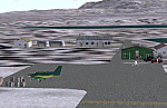
Images related to this file:
File Description:

FS2004 Scenery for Sunnyvale Air Station circa 1933. Known for 75 years as Moffett Field Naval Air Station, this unique site started life as Sunyvale Field (then Air Station) and was planned as the west coast base of the new Dirigible U.S.S. Macon.
The Macon was a new direction for airships in that it carried a squadron of fighter/scout aircraft and would provide for the U.S. Navy a 'carrier in the sky'. To provide for this new queen of the skies a new base was created with a unique hangar, for many years the largest free-standing wood construction in world.
This scenery attempts to capture Sunnyvale as it was first opened in 1933. I have taken a few liberties like adding in full grown trees that were part of the original master plan but I believe you will find this base captures the spirit of the original. Scenery contains custom FSDS and Gmax models as well as period AI from J.R. Lucariny (F9C SParrowhawk) and a custom repaint of the default Ford Trimotor by Ed Moore and Gary Smith.
| Filename: | Sunnyvale_Air_Station_circa_1933.zip |
| License: | Freeware, limited distribution |
| Added: | 2nd April 2012, 11:51:11 |
| Downloads: | 436 |
| Author: | John Stinstrom |
| Size: | 6.59 MB |
| Category: Flight Simulator 2004 - Scenery | |
| PAIW Wales, Alaska, USA |
|
Images related to this file:
File Description:
Googly scenery for Wales - a small domestic airport on the western coast of Alaska that is poorly provided for in Flight Simulator 2004. These scenery files add taxiways, aprons, buildings and other airport features, so that you and your "AI" traffic can land, taxi, park and take off in a realistic manner.
Wales is a small village with a population of just over 150 people, so the facilities at this 4000 foot gravel airstrip are fairly limited. The airport is allocated the ICAO code PAIW, although Microsoft has ignored this in Flight Simulator and uses the IATA ticket code IWK. Wales is served by light aircraft from airlines such as Bering Air, Cape Smythe Air, Frontier Flying Service, and Hageland Aviation Services. You might find it a convenient stopping-off point for a quick trip across to Russia - this is about as close as you can get and a nip across the Bering Strait will find you there in no time.
The scenery does not purport to be ultra-accurate. Based on high-detail satellite imagery from Google Earth, the layout is proportionally correct but the added airport features, such as buildings, are built from default Microsoft objects and add-on libraries so will not look like the real thing.
You are not obliged to download and install any additional scenery libraries, but to enjoy this scenery in its entirety, you may wish to. It will work fine, with or without.
[File re-uploaded at request of AVSIM]
| Filename: | PAIW_Wales_Alaska_USA.zip |
| License: | Freeware |
| Added: | 26th June 2010, 13:51:45 |
| Downloads: | 1,266 |
| Author: | John Hinson |
| Size: | 76.81 KB |
© 2001-2026 AVSIM Online
All Rights Reserved
Privacy Policy |