
Where Flight Simulation Enthusiasts Gather from Around the World!
AVSIM Library - Search Results

| Category: Flight Simulator 2004 - Scenery | |
| Smith Mountain Lake, two private seaports - Virginia, USA |

|
Images related to this file:
File Description:
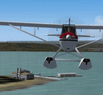
Smith Mountain Lake scenery is made to blend with autogen scenery (default). VA48 & 7VA7 seaports are left default so one may add their own AFCAD & AI traffic. Included is an EZ-landclass SmithMtnLake.bgl, its' EZL & RAW files (source files) so one may edit the area using EZ-landclass that's available as freeware download. Another distinction besides a very popular vacation lake is American Electric Powers' hydro-electric dam.
| Filename: | Smith_Mountain_Lake_two_private_seaports__Virginia.zip |
| License: | Freeware |
| Added: | 11th July 2015, 11:24:40 |
| Downloads: | 184 |
| Author: | Rick Connolly |
| Size: | 14.93 MB |
| Category: Flight Simulator 2004 - Scenery | |
| Western Australia 11 airports |
|
File Description:
The FS2004 is missing. I created 11 additional airports in Western Australia for gold, diamonds, and other mines all are new developed mines that are missing in FS2004. The airports are Port Hedland, Wodgina -YWGA * Gudai-Darri Mine - YKDD * Carosue Dam Gold Mine - YSCD * Eliwana - YEWA * Yamarna - YYRN * Koolan Island Center - YKLC * Koolan Island (old) - YKLI * Gruyere - YGRM * Iron Bridge Mine - YIBO * Ginbata/Roy Hill Mine - YGIA * Degrussa - YDGU *
| Filename: | Western_Australia_11_airports.zip |
| License: | Freeware |
| Added: | 17th September 2021, 15:48:50 |
| Downloads: | 171 |
| Author: | Stuart John Gilbert II |
| Size: | 15.42 MB |
| Category: Flight Simulator 2004 - Scenery | |
| Howick Airfield (FAHC), South Africa |
|
Images related to this file:
File Description:
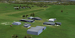
This package will add a custom (Gmax) made Howick Airfield (FAHC), KwaZulu Natal, South Africa with photoreal textures and seasonal ground textures.
Howick is a small town in the KwaZulu Natal Midlands just off the N3 freeway which connects Johannesburg and Durban and home to the famous Howick waterfall. The Umgeni river falls 95m (311 ft) over the cliffs on the way to the Indian Ocean. The town is also home to the Midmar dam. This dam is very well known as being the location of the annual Midmar Mile swimming event which, in 2009, was recognized by the Guinness Book of World Records as the world's largest open water swimming event with 13 755 competitors taking part.
The sloped grass runway is aligned 16/34 and 825m long and sits at an elevation of 3 615ft. Both runways have obstacles on the approach, with powerlines 730m from the threshold of runway 16, while runway 34's approach have hills around 900m before the threshold. The sloped runway has been created in FS2004 within the limits of the simulator itself.
| Filename: | Howick_Airfield_FAHC_South_Africa.zip |
| License: | Freeware, limited distribution |
| Added: | 15th January 2021, 20:25:51 |
| Downloads: | 201 |
| Author: | Kobus van Wyk |
| Size: | 7.67 MB |
| Category: Flight Simulator 2004 - Scenery | |
| LPMO Morargil Airfield, Portugal |
|
Images related to this file:
File Description:
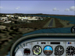
LPMO Morargil Airfield.
This is a certified airfield in the neighbourhood of Mora Village (North Alentejo) in the middle south of Portugal, about 4.5 miles SSE from Montargil dam. The house painting respects the traditional Alentejo houses.
This scenery is only compatible with Portugal Terrain from PTSIM (http://www.ptsim.com) and is based on digital pictures taken at the place, accurate real measures by Aerodromos de Portugal (http://www.pelicano.com.pt/zmapa.html) and Google Earth. Freeware. For Microsoft FS2004.NOT tested for FSX
| Filename: | LPMO_Morargil_Airfield_Portugal.zip |
| License: | Freeware |
| Added: | 1st March 2013, 22:39:29 |
| Downloads: | 375 |
| Author: | Joao A. Graca Ferreira |
| Size: | 8.67 MB |
| Category: Flight Simulator 2004 - Scenery | |
| WV71 - Lieving Airport - West Virginia, USA |
|
Images related to this file:
File Description:
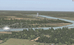
Racine Locks & Dam is a local vfr landmark for transits across the lower Allegheny Plateau. Included files are xml autogen, ezlandclass and custom bgl files with textures. I've named the files so that they are self explainable. This scenery is made to blend with autogen scenery (default) for FS9 and my Central Appalachia Land Class project. I've added the lower Big Sandy Valley project, too. It corrects a few default mistakes and adds bridges like at I-64 and in the Ashland Kentucky and Huntington WV area.
| Filename: | WV71__Lieving_Airport__West_Virginia_USA.zip |
| License: | Freeware |
| Added: | 9th July 2015, 17:29:21 |
| Downloads: | 213 |
| Author: | Rick Connolly |
| Size: | 5.64 MB |
| Category: Flight Simulator 2004 - Scenery | |
| Perth, Western Australia - Metro Area Pack v1.0 |
|
File Description:
Navigation landmarks for pilots flying around Perth, in particular for pilots flying out of Jandakot Airport. Includes totally reworked coastline, Swan and Canning rivers, and the following nav points - Murdoch open space, Adventure World, Henderson Shipyards, Fremantle harbour, Pt Walter, Cottesloe, Canning, Shelley and Mt Henry bridges, Langley Park, Lake Monger and Herdsmen Lake, Canning Dam, all lakes south of Canning River (Bibra, Thompson etc), Penguin and Carnak Islands. For FS2004 Only, to be used with our Sth West landclass and Jandakot airport. http://www.westsim.com.au/
| Filename: | Perth_Western_Australia__Metro_Area_Pack_v10.zip |
| License: | Freeware, limited distribution |
| Added: | 15th December 2003, 16:13:32 |
| Downloads: | 3,052 |
| Author: | Westsim Design Group - Derek Kippo and Jarrad Marshall |
| Size: | 418.15 KB |
| Category: Flight Simulator 2004 - Scenery | |
| Arnot Power Station, South Africa |
|
Images related to this file:
File Description:

Arnot Power Station, South Africa with photoreal textures and seasonal textures.
The power station, airfield building, objects and fences were all custom made in Gmax, while Rietkuil village (Arnot) is also represented by means of almost 800 hand placed autogen buildings. Arnot is also well known for the large amount of trees in the area, on approach to rwy 13 and lining the road seperating the village from the power station, and these are also represented by more than 4 000 hand placed trees. The "Ash-dam" south of the runway is also included.
| Filename: | Arnot_Power_Station_South_Africa.zip |
| License: | Freeware, limited distribution |
| Added: | 16th November 2012, 23:45:27 |
| Downloads: | 542 |
| Author: | Kobus van Wyk |
| Size: | 11.86 MB |
| Category: Flight Simulator 2004 - Scenery | |
| Reservoirs and Lakes of Lesotho and Western Natal, South Africa |
|
File Description:
Replacement files for water bodies of eastern South Africa, in and near the Drakensberg Range (S28.1-29.5 E28.3-30.0). Natural and man-made lakes are now in their accurate position and elevation. Includes the Katse Dam reservoir in Lesotho as well as about 100 smaller lakes in Lesotho and western Natal not present in the FS default scenery. Based on a watermask derived from Landsat 7 ETM+ satellite data and compiled with a beta version of Jim Keir's "Slartibartfast" utility. Meant to be used with the Aeroworx SRTM LOD9 South Africa mesh.
| Filename: | Reservoirs_and_Lakes_of_Lesotho_and_Western_Natal_.zip |
| License: | Freeware, limited distribution |
| Added: | 8th May 2004, 02:43:38 |
| Downloads: | 6,202 |
| Author: | Holger Sandmann, Aeroworx |
| Size: | 464.27 KB |
| Category: Flight Simulator 2004 - Scenery | |
| Argentina Villa Rumipal/Rio Tercero |
|
Images related to this file:
File Description:
This scenery was requested by Federico Malfu Sanchez, who also did all the legwork to find images and data, and as well did the complete Beta testing.
The area surrounding has been edited to help VFR pilots find their way. The whole LOD 8 tile the scenery is on has been resampled with SRTM3 data at LOD 13 level. The Rio Tercero lake has been configured to satellite images and rivers and roads follow their actual mapped courses.
Additionally the Rio Tercero dam and hydro electric plant, as well as other VFR relevant landmarks, have been included.
| Filename: | Argentina_Villa_RumipalRio_Tercero.zip |
| License: | Freeware, limited distribution |
| Added: | 12th May 2010, 00:19:55 |
| Downloads: | 315 |
| Author: | Alf B. Meier |
| Size: | 1.62 MB |
| Category: Flight Simulator 2004 - Scenery | |
| Page (KPGA), Lake Powell West, Utah/Arizona, Photo-Scenery (FS9 & FSX) |
|
Images related to this file:
File Description:
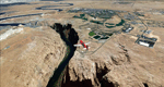
This scenery covers the western part of Lake Powell, the city of Page (KPGA), the Vermillion Cliffs, Glenn Canyon just south of Glenn Canyon Dam, the northern part of Marble Canyon, Paria Canyon, Cockscomb, etc, etc. Spectacular! To explore the scenery depart from Page Municipal Airport (KPGA). High resolution versions of this scenery for FS9 and FSX (much sharper, but larger and multiple downloads) are available at www.blueskyscenery.com/CNY_South3West3.html . The screenies are taken from the high-res versions, so expect this version to be slightly more blurry. YourDonation@Work: Dedicated to William, Veit and Michele.
| Filename: | Page_KPGA_Lake_Powell_West_UtahArizona_PhotoScener.zip |
| License: | Freeware, limited distribution |
| Added: | 3rd March 2010, 21:26:32 |
| Downloads: | 1,818 |
| Author: | Gottfried Razek - blueskyscenery.com |
| Size: | 92.41 MB |
© 2001-2026 AVSIM Online
All Rights Reserved
Privacy Policy |