
Where Flight Simulation Enthusiasts Gather from Around the World!
AVSIM Library - Search Results

| Category: Flight Simulator 2004 - Scenery | |
| PAUT - Akun Island - Alaska, USA |

|
Images related to this file:
File Description:
Akun Island is close to Akutan, only 7 miles away from the village and the Trident fish processing plant that is just west of the village. Unfortunately those 7 miles are over the sea, as the airport has been built on a different island where there are fewer hills. The link is by hovercraft, which is included as AI in this post along with a "seaport" that boasts only an apron down by the beach. PAUT has a single runway aligned 09-27 which is 4,500 feet long and has a surrounding gravel base. There are daily flights from Dutch Harbor by Grant Aviation, more than one if more are required. The Ai contains these flights, plus a late afternoon Coastguard helicopter flight is added to the revised St Paul Island AI included here. Adjacent to the airport there is a camp for housing labour who were employed on the airport construction, and this is now available for wildlife survey teams or whoever else needs to find accommodation while working on Akun Island.
| Filename: | akun.zip |
| License: | Freeware, limited distribution |
| Added: | 27th January 2015, 23:11:43 |
| Downloads: | 461 |
| Author: | Roger Wensley |
| Size: | 4.25 MB |
| Category: Flight Simulator 2004 - Scenery | |
| PAHT - Amchitka - Aleutians, Alaska - USA |
|
Images related to this file:
File Description:
Amchitka is near the western end of the Aleutian chain of islands in Alaska, around 180 miles west of Adak, and was not included in FS9. There is no small town on Amchitka Island, which is why it was used for atom bomb testing after being closed down as an Air Force base. There are three runways from the 1940's, the largest of which is aligned 07-25 and just over 10,000 feet of overgrown asphalt 300 feet wide. The second runway is aligned 15-33 and 6,000 feet (also 300 feet wide) and the third is 05-23 and 5,000 feet. The whole eastern end of the island is crowded with old munitions storage areas and other military paraphernalia, including old quonset huts; some of those are included here. There are also some old buildings still standing but on their way to becoming piles of old wood or rust, and some of these are included. There is almost no visual information available about Amchitka; even Google Earth has snow obscuring what buildings still exist and where they are, so much of this is at best only approximate apart from the two large hangars. There are no markings, lights, signage, or a control tower.
| Filename: | amchitka.zip |
| License: | Freeware, limited distribution |
| Added: | 6th February 2015, 00:06:26 |
| Downloads: | 260 |
| Author: | Roger Wensley |
| Size: | 2.63 MB |
| Category: Flight Simulator 2004 - Scenery | |
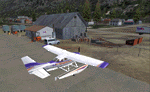
| PAWS - Wasilla - Anchorage, Alaska - USA |
|
Images related to this file:
File Description:
Wasilla PAWS is in Alaska, some 27 miles northeast of Anchorage and 11 miles due north of Birchwood, on the northern side of the Knik Arm. It is, like Birchwood, a small version of Merrill Field for mostly GA aircraft and private hangars, with some maintenance shops. The town of Wasilla is shown in FS9 and is quite large. There are a bunch of private airfields within a ten mile radius and some of these will be posted in this series, as will some other larger airfields. The main runway is around 3,700 feet long, aligned 03-21 and asphalted and lit, as are the taxiways. Again, like Birchwood, there is also a shorter and parallel runway that is grass and which receives no winter maintenance, for winter use by planes that are on skis.
| Filename: | wasilla_ak.zip |
| License: | Freeware, limited distribution |
| Added: | 13th October 2014, 15:04:08 |
| Downloads: | 306 |
| Author: | Roger Wensley |
| Size: | 19.11 MB |
| Category: Flight Simulator 2004 - Scenery | |
| PAAT (ATU) - Attu - Alaska, USA |
|
Images related to this file:
File Description:
Attu is AT the western end of the Aleutian chain of islands in Alaska, around 40 miles west of Shemya. There was small village on Attu before the Japanese invasion in mid 1942, but the island is now uninhabited. The Coast Guard Loran navigation station remains in place, though it is no longer in operation and visitors to the island are now either tourists or wildlife experts conducting surveys of numbers of nesting birds, etc. The runway still usable is aligned 02-20 and 5,800 feet long; right hand circuits on 02 to stay away from rising ground to the west. The "terminal" building has lost its sign regarding the Horny Bird, removed in 2010 by one of the last of the station operators, but the building is still there, as are some sheds and shacks that lately were used for the uncomfortable accommodation of bird counters. FS9 has used an incorrect icao identification for Attu but correcting it now would make life complicated so ATU it is and shall remain. I have removed the default FS9 roads that came complete with streetlights and telephone poles and replaced and amended the layout with gravel roads to better resemble real life, though the island shape is at best approximate, as is usual in FS9.
| Filename: | attu.zip |
| License: | Freeware, limited distribution |
| Added: | 2nd March 2015, 20:58:09 |
| Downloads: | 269 |
| Author: | Roger Wensley |
| Size: | 3.33 MB |
| Category: Flight Simulator 2004 - Scenery | |
| PAMR - Merrill Field - Anchorage, Alaska |
|
Images related to this file:
File Description:
Merrill Field is in Anchorage Alaska, between Anchorage International to the southwest and and Elmendorf Air Force Base to the north. It caters for general aviation and is the land equivalent of the Lake Hood float plane base (see my post) with fuel and numerous maintenance facilities, and several hundred parking spots for small planes. There are three runways, and the longest is 4,000 feet of 100 feet wide asphalt, the second 2,635 feet of asphalt 75 feet wide, and the third 2,000 feet of 60 feet wide gravel. It is a controlled airfield with a modern control tower. There are almost 50 buildings on the field and three quarters of them have been modeled specifically for this scenery. The download includes a LITE version for older computers as there are a lot of static parked aircraft.
| Filename: | merrill_field.zip |
| License: | Freeware, limited distribution |
| Added: | 3rd January 2011, 23:11:31 |
| Downloads: | 1,103 |
| Author: | Roger Wensley |
| Size: | 7.19 MB |
| Category: Flight Simulator 2004 - Scenery | |
| Metro Field MTF in Fairbanks Alaska |
|
Images related to this file:
File Description:
Metro Field is more of a float plane "pond" than a field, close to and northeast of Fairbanks International Airport in Alaska. There is a gravel strip alongside the water, but the "strip" is actually a gravel road that functions as a runway when required. And if that sounds familiar it is also pretty much the description for nearby Chena Marina, though Metro is nowhere near as busy. This is one of four float plane bases around Fairbanks. You will definitely need Ultimate Terrain Alaska Canada.
| Filename: | metro_field_fairbanks.zip |
| License: | Freeware, limited distribution |
| Added: | 21st August 2010, 03:27:58 |
| Downloads: | 364 |
| Author: | Roger Wensley |
| Size: | 996 KB |
| Category: Flight Simulator 2004 - Scenery | |
| FedEx depot, Gustavus AK |
|
Images related to this file:
File Description:
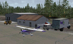
A small scenery enhancement created with EZ Scenery for Gustavus, AK (Alaska). Adds a Fed Ex depot to the area. Complete with hangars, buildings, forklifts, etc. Utilizes EZ Scenery objects. EZ Scenery libraries previously installed required.
| Filename: | fdxpags1.zip |
| License: | Freeware |
| Added: | 31st May 2010, 10:58:12 |
| Downloads: | 959 |
| Author: | Brad Allen |
| Size: | 143 KB |
| Category: Flight Simulator 2004 - Scenery | |
| FedEx depot, Skagway AK |
|
Images related to this file:
File Description:
A small scenery enhancement created with EZ Scenery for Skagway, AK (Alaska). Adds a Fed Ex depot to the area. Complete with hangars, buildings, forklifts, etc. Utilizes EZ Scenery objects. EZ Scenery libraries previously installed required.
| Filename: | fdxpagy1.zip |
| License: | Freeware |
| Added: | 31st May 2010, 11:02:09 |
| Downloads: | 919 |
| Author: | Brad Allen |
| Size: | 131 KB |
| Category: Flight Simulator 2004 - Scenery | |
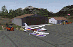
| PABV - Birchwood airfield - Anchorage, Alaska - USA |
|
Images related to this file:
File Description:
Birchwood PABV is in Alaska, some 20 miles northeast of Anchorage, on the south shore of Knik Arm. It is a smaller version of Merrill Field, almost entirely for just GA aircraft and the maintenance shops that a gathering of such aircraft attracts. The main runway is just over 4,000 feet long, aligned L01-R19 and asphalted and lit; this last is even more important in Alaska with short winter days. There is also a shorter and parallel runway that is gravel and which receives no winter maintenance; this is for winter use by planes that are on skis, rather than wheel/skis. This is not unusual and is found at other Alaska airfields. This scenery provides a place to fly to from my previous posts of Merrill Field and Lake Hood close to Anchorage. There will be others in this series, on the northern side of Knik Arm.
| Filename: | birchwood_ak.zip |
| License: | Freeware, limited distribution |
| Added: | 7th October 2014, 19:41:37 |
| Downloads: | 601 |
| Author: | Roger Wensley |
| Size: | 22.56 MB |
| Category: Flight Simulator 2004 - Scenery | |
| FedEx depot, Petersburg AK |
|
Images related to this file:
File Description:
A small scenery enhancement created with EZ Scenery for Petersburg, AK (Alaska). Using Tongass Fjords. Adds a Fed Ex depot to the area. Complete with hangars, buildings, forklifts, etc. Utilizes EZ Scenery objects. EZ Scenery libraries previously installed required.
| Filename: | fdxpapg1.zip |
| License: | Freeware |
| Added: | 31st May 2010, 10:59:45 |
| Downloads: | 948 |
| Author: | Brad Allen |
| Size: | 133 KB |
© 2001-2025 AVSIM Online
All Rights Reserved