
Where Flight Simulation Enthusiasts Gather from Around the World!
AVSIM Library - Search Results

| Category: Flight Simulator 2004 - Scenery | |
| Loney's Alaska Vol 1 |

|
File Description:
FS2004 Scenery-Loney's Alaska vol1. This download comprises of 6 Alaskan airports enhanced using Rwy12 and EZ Scenery. The airports include English Bay (KEB), Port Graham (PGM), Seldovia (PASO), Oyster Cove (2AK4), Kasitsna (5Z7) and Jakolof Bay (4Z9). There are some challenging approaches. Includes AI traffic through Traffic Tools with modified AFCAD files. Rwy12 and EZ Scenery libraries required. By John B. Loney, Jr.
| Filename: | lakvol1.zip |
| License: | Freeware |
| Added: | 19th February 2006, 23:59:57 |
| Downloads: | 1,691 |
| Author: | John B. Loney, Jr. |
| Size: | 773 KB |
| Category: Flight Simulator 2004 - Scenery | |
| PAIW Wales, Alaska, USA |
|
Images related to this file:
File Description:
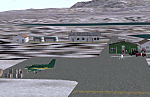
Googly scenery for Wales - a small domestic airport on the western coast of Alaska that is poorly provided for in Flight Simulator 2004. These scenery files add taxiways, aprons, buildings and other airport features, so that you and your "AI" traffic can land, taxi, park and take off in a realistic manner.
Wales is a small village with a population of just over 150 people, so the facilities at this 4000 foot gravel airstrip are fairly limited. The airport is allocated the ICAO code PAIW, although Microsoft has ignored this in Flight Simulator and uses the IATA ticket code IWK. Wales is served by light aircraft from airlines such as Bering Air, Cape Smythe Air, Frontier Flying Service, and Hageland Aviation Services. You might find it a convenient stopping-off point for a quick trip across to Russia - this is about as close as you can get and a nip across the Bering Strait will find you there in no time.
The scenery does not purport to be ultra-accurate. Based on high-detail satellite imagery from Google Earth, the layout is proportionally correct but the added airport features, such as buildings, are built from default Microsoft objects and add-on libraries so will not look like the real thing.
You are not obliged to download and install any additional scenery libraries, but to enjoy this scenery in its entirety, you may wish to. It will work fine, with or without.
[File re-uploaded at request of AVSIM]
| Filename: | paiw.zip |
| License: | Freeware |
| Added: | 26th June 2010, 13:51:45 |
| Downloads: | 1,256 |
| Author: | John Hinson |
| Size: | 77 KB |
| Category: Flight Simulator 2004 - Scenery | |
| Bettles PABT in Alaska |
|
Images related to this file:
File Description:
Bettles is around 175 miles north of Fairbanks in ALaska, and 25 miles north of the Arctic Circle. It is also where James "Andy" Andersen started flying for Wien Airlines and where he spent the 20 years between 1947 and 1967. Read "Arctic Bush Pilot" by Andy and Jim Rearden for his story of those 20 years flying the bush. Bettles PABT is the gravel strip and due to the limitations of FS9 AI the float base on the adjacent river has to be separately named PABX. Bettles village (old Bettles) used to be 2 miles southwest of the field, but has now slowly relocated close to the strip. In this download there is an AFCAD folder, landclass folders, a scenery folder, and a traffic folder. You will need Ultimate Terrain Alaska Canada.
| Filename: | bettles_alaska.zip |
| License: | Freeware, limited distribution |
| Added: | 22nd August 2010, 16:21:12 |
| Downloads: | 737 |
| Author: | Roger Wensley |
| Size: | 2.75 MB |
| Category: Flight Simulator 2004 - Scenery | |
| Loney's Alaska Vol. 4 |
|
Images related to this file:
File Description:
FS2004 Scenery-Loney's Alaska vol4. This download comprises of 5 more Alaskan airports enhanced using EZ Scenery. The airports include Wales (IWK), Tin City LRRS (PATC), Teller (K54), Buck Creek (AK98) and Brevig Mission (KTS). Includes AI traffic through Traffic Tools with modified AFCAD files. EZ Scenery libraries required. By John B. Loney, Jr.
| Filename: | lakvol4.zip |
| License: | Freeware, limited distribution |
| Added: | 3rd June 2010, 00:44:50 |
| Downloads: | 1,480 |
| Author: | John B. Loney, Jr. |
| Size: | 644 KB |
| Category: Flight Simulator 2004 - Scenery | |
| Galena PAKP in Alaska |
|
Images related to this file:
File Description:
Galena is a village on the Yukon River, around 30 miles east of the corner where the westward running river turns south. The population is just under 500 and the city is noted for its educational facilities that attract residential students from across the state. Adjacent to the city is the Galena Air Force Station that previously shared the use of the Edward G. Pitna Snr. airport until 2007, when the station was closed and the air force personnel left. The station facilities have been taken over by the community and the airport became the largest state-maintained airport in the interior of Alaska. Substantial resurfacing and finishing work was then carried out, and the new asphalt runway is now 6,000 feet long and aligned 7-25, with VASI at both ends and ILS on 25. There is a secondary gravel runway beside part of the main asphalt runway, and this is treated in radio announcements as if it is not a separate runway and landing or take off are on the adjacent asphalt. The airport is serviced by ERA (now called Ravn) and Wrights Air, with cargo flights by the eternal Everts. Included here is a small modification for Allakaket, which deletes a single remaining stock FS9 taxiway light. The AI included here also provided Allakaket with a Saturday Everts delivery flight, but I neglected to mention that before. A note here about my scenery making. There will not be many more to follow this as I am almost at the end of the photos I either took or found for scenery purposes, plus I expect to move on from FS9 at some point during next year.
| Filename: | galena.zip |
| License: | Freeware, limited distribution |
| Added: | 27th November 2019, 19:14:00 |
| Downloads: | 231 |
| Author: | Roger Wensley |
| Size: | 14.55 MB |
| Category: Flight Simulator 2004 - Scenery | |
| PABR - Barrow - Alaska, USA |
|
Images related to this file:
File Description:
The town of Barrow is in the far north of Alaska, and is best known in flying circles as the place where Wiley Post crashed his floatplane on takeoff and killed himself and Will Rogers. The crash was some 15 miles south of Barrow and was "assisted" by the mismatched fuselage, wings, and floats that had been assembled to create the floatplane. The Barrow population is largely Inupiat and totals some 4,400. The downtown area of Barrow is immediately north of the airport. The second and largest part of Barrow is further north past a string of lagoons and is locally called Browerville. To the northeast along the coast is the smallest part around what used to be the Naval Arctic Research Lab, and is now a college. To the east of this are the DEW buildings, plus two large navy hangars and the gravel runway that was used to serve the DEW station. The PABR runway is aligned 06-24 in FS9 and is 7,100 feet long and 150 feet wide, built on top of a gravel base and surround that copes with the underlying permafrost. There is PAPI at both ends and an ILS and approach lights on 06; 06 circuits are to the right. The airport notes include a warning that the apron is not a standard width and that large planes that are enroute to the far end of the runway will not be able to taxi past a plane parked at the gate and should use the runway as a taxiway, then turn and takeoff. FS9 AI cannot cope with that, so the apron here is wider. There are, in real life and the AI, daily flights by Air Alaska (three at least) and Era (several, and which is now called Ravn, hence the new hangar door motif) and air cargo flights by Northern Air Cargo and Everts, plus GA. The buildings have been made with photographic textures or textures made from reference photos. I decided that while 500+ scenery objects was probably ok for most people the required 900+ to "make" the town of Barrow would likely not be. The auto-generated FS9 town objects could not be left as Barrow with trees would not look at all like reality; I have "faded" the density of the town buildings into the distance from the airport.
| Filename: | barrow_alaska_v1.zip |
| License: | Freeware, limited distribution |
| Added: | 17th May 2016, 09:32:36 |
| Downloads: | 953 |
| Author: | Roger Wensley |
| Size: | 15.76 MB |
| Category: Flight Simulator 2004 - Scenery | |
| PADL - Dillingham - Alaska, USA |
|
Images related to this file:
File Description:
Dillingham is a town with a population of around 2,300 at the southeast corner of the Bering Sea in Bristol Bay, 70 miles west of King Salmon. The town's economical well being is based on the commercial price of salmon and the numerous surrounding sport fishing lodges. FS9 shows the town as way more extensive than it is; the landclass textures correct this. The airport is a mile west of the town and has a single runway 6,400 feet long and orientated 01-19. There are scheduled passenger flights by Alaska Air (numerous in summer and non-existant in winter) and PenAir (year around) plus cargo flights by Everts and Northern Air Transport, and local scheduled flights by Grant Air; the AI includes these, plus GA. The GA gravel apron is behind the main apron and across a road, which is unusual. The parking on the asphalt apron is marked; in actuality there are no markings but landing at a field in FS9 that doesn't have a control tower leaves one wondering where to go; the six spots at the far northern end are unused by AI and free for visitors.
| Filename: | dillingham.zip |
| License: | Freeware, limited distribution |
| Added: | 14th May 2015, 17:35:29 |
| Downloads: | 375 |
| Author: | Roger Wensley |
| Size: | 10.75 MB |
| Category: Flight Simulator 2004 - Scenery | |
| Shaktoolik 2C7 in Alaska |
|
Images related to this file:
File Description:
Shaktoolik is a coastal village 35 miles north of Unalakleet, with a fishing population of around 250. It was originally established inland on the Shaktoolik River but moved to the coast in 1933. Due to storms and erosion it was again moved in 1967, to its current location 2 miles further north. Confusingly, what is called "New Shaktoolik 38A" was in fact only "new" in 1967 and has since been replaced by "Shaktoolik 2C7" further north, built on wider land with a longer gravel runway of 4,000 feet. 38A is still visible but unusable, with the sheds being used for other purposes. There are flights from Unalakleet, included in the AI here as a further modification to the Bethel PABE AI. A note here about my scenery making. This is post number 500 and there will not be many more to follow this as I am almost at the end of the photos I either took or found for scenery purposes. There is a limit to what can be located online and I have already been making use of the little there is; eg Unalakleet. So, if you are near an airport (preferably Canadian or Alaskan) and have a camera..... Let me know.
| Filename: | shaktoolik.zip |
| License: | Freeware, limited distribution |
| Added: | 27th July 2019, 21:00:56 |
| Downloads: | 101 |
| Author: | Roger Wensley |
| Size: | 4.17 MB |
| Category: Flight Simulator 2004 - Scenery | |
| Deering PADE in Alaska |
|
Images related to this file:
File Description:
Deering is a coastal village around 55 miles southwest of Kotzebue, living from fishing and the land and with a population of around 130. The airfield is inland from the coast and has two gravel runways, 11-29 of just under 3,000 feet and 2-20 of 3,700 feet; the US is the only country that names runways with single numerals, hence 2-20 that in Canada would be 02-20. And Canada, which is a metric country and gives speed limits on roads in kilometres per hour, flies in feet and not metres for runway lengths and flight levels. The two runways could have something to do with there being a National Guard Armoury in the village, and perhaps personnel being flown in for exercises in the local countryside. Apart from the airfield itself, and it's buildings, this scenery modifies the local (mostly treeless) land class, reduces the village size to reality, and creates a new airfield background. Bering Air flies into Deering from Kotzebue and is included in the AI. A note here about my scenery making. This is post number 504 and there will not be many more to follow this as I am almost at the end of the photos I either took or found for scenery purposes. There is a limit to what can be located online and I have already been making use of the little there is; eg Unalakleet. So, if you are near an airport (preferably Canadian or Alaskan) and have a camera..... Let me know.
| Filename: | deering_ak.zip |
| License: | Freeware, limited distribution |
| Added: | 7th August 2019, 16:37:12 |
| Downloads: | 127 |
| Author: | Roger Wensley |
| Size: | 4.52 MB |
| Category: Flight Simulator 2004 - Scenery | |
| Buckland PABL in Alaska |
|
Images related to this file:
File Description:
Buckland is a village on a small river, around 45 miles east of Deering and 15 miles inland from the river mouth. Like Deering, the population of 420 live from fishing and the land. The airfield is close by and has a gravel runway aligned 10-24 and 3,300 feet long with VASI at both ends. Apart from the airfield itself, and it's buildings, this scenery modifies the local (mostly treeless) land class, adds village buildings while reducing the village size to reality, and creates a new airfield background. Bering Air flies into Buckland from Kotzebue and is included in the AI. A note here about my scenery making. This is post number 505 and there will not be many more to follow this as I am almost at the end of the photos I either took or found for scenery purposes. There is a limit to what can be located online and I have already been making use of the little there is; eg Unalakleet. So, if you are near an airport (preferably Canadian or Alaskan) and have a camera..... Let me know.
| Filename: | buckland_ak.zip |
| License: | Freeware, limited distribution |
| Added: | 10th August 2019, 18:51:45 |
| Downloads: | 134 |
| Author: | Roger Wensley |
| Size: | 4.28 MB |
© 2001-2025 AVSIM Online
All Rights Reserved