
Where Flight Simulation Enthusiasts Gather from Around the World!
AVSIM Library - Search Results

| Category: Flight Simulator 2004 - Scenery | |
| Phoenix, Arizona 30 Meter Terrain Mesh Scenery |

|
File Description:
Mesh Scenery for Microsoft Flight Simulator 2004 and 2002.USGS NED 30 meter (1 arc-second), resampled to LOD10 (38.2 meters). This terrain mesh is centered at Phoenix, Arizona. Coverage area: From about West 111° to West 113° and North 33° to North 34°.
| Filename: | Phoenix_Arizona_30_Meter_Terrain_Mesh_Scenery.zip |
| License: | Freeware |
| Added: | 3rd January 2004, 19:53:36 |
| Downloads: | 3,718 |
| Author: | Phil Cruikshank |
| Size: | 4.66 MB |
| Category: Flight Simulator 2004 - Scenery | |
| SKBS - Jose Celestino Mutis - Bahia Solano, Colombia |
|
File Description:
I made this scenery using standard objects. I corrected the airport altitude which is 80ft instead of 535 ft of the default scenery. Therefore the airport scenery should be used with a mesh scenery, e.g. the freeware mesh of Colombia by Raimondo Taburet (flightsim.com).
| Filename: | SKBS__Jose_Celestino_Mutis__Bahia_Solano_Colombia.zip |
| License: | Freeware |
| Added: | 22nd June 2012, 21:55:44 |
| Downloads: | 730 |
| Author: | Detlev J. Rohmer |
| Size: | 8.05 MB |
| Category: Flight Simulator 2004 - Scenery | |
| Spain and Portugal SRTM Scenery Mesh |
|
File Description:
This is a terrain mesh scenery for Spain (with Balearic Islands) and Portugal.
Based on SRTM Data (3 arc/ sec), generated with Matthew Styles's program "SRTM To BGL v1.04", sampled to LOD9 resolution (76m).
While tested under Fs2004, this mesh should also run in FS2002.
| Filename: | Spain_and_Portugal_SRTM_Scenery_Mesh.zip |
| License: | Freeware |
| Added: | 5th November 2003, 19:58:55 |
| Downloads: | 7,007 |
| Author: | Ricard Alvarez |
| Size: | 91.24 MB |
| Category: Flight Simulator 2004 - Scenery | |
| Himalayas LOD9 Base Mesh, Volume 1 - Southeastern Ranges |
|
Images related to this file:
File Description:
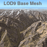
Detailed terrain mesh of the Southeastern Himalayan Ranges, N26-32 E90-98. The files in this package are based on Shuttle Radar (SRTM) Version 2 data but with many of the void areas, especially the most significant sections, filled with elevation data generated from topographic maps by Jonathan de Ferranti. While Jonathan's work is unrelated to flight simulation he kindly gave me permission to compile his data for use in FS. The result is a wonderful improvement in detail and accuracy over any existing mesh file, freeware or commercial, based on SRTM or DTED data alone.
Due to the large area of the Himalayas I've compiled the source data as two separate series: the "Himalayan Peaks" series covers prominent mountains and ranges in higher detail and locally overrides any existing LOD9 terrain mesh. In addition, a LOD9 "base mesh" series, with LOD8 and LOD7 "buffer" mesh files, covering the entire Himalayas, is meant for those who do not yet have an add-on terrain mesh of these beautiful mountains.
| Filename: | Himalayas_LOD9_Base_Mesh_Volume_1__Southeastern_Ra.zip |
| License: | Freeware, limited distribution |
| Added: | 29th May 2010, 09:01:26 |
| Downloads: | 10,298 |
| Author: | Holger Sandmann, Jonathan de Ferranti |
| Size: | 71.82 MB |
| Category: Flight Simulator 2004 - Scenery | |
| Himalayas LOD9 Base Mesh, Volume 2 - Southcentral Ranges |
|
Images related to this file:
File Description:

Detailed terrain mesh of the Southcentral Himalayan Ranges, N26-32 E82-90. The files in this package are based on Shuttle Radar (SRTM) Version 2 data but with many of the void areas, especially the most significant sections, filled with elevation data generated from topographic maps by Jonathan de Ferranti. While Jonathan's work is unrelated to flight simulation he kindly gave me permission to compile his data for use in FS. The result is a wonderful improvement in detail and accuracy over any existing mesh file, freeware or commercial, based on SRTM or DTED data alone.
Due to the large area of the Himalayas I've compiled the source data as two separate series: the "Himalayan Peaks" series covers prominent mountains and ranges in higher detail and locally overrides any existing LOD9 terrain mesh. In addition, a LOD9 "base mesh" series, with LOD8 and LOD7 "buffer" mesh files, covering the entire Himalayas, is meant for those who do not yet have an add-on terrain mesh of these beautiful mountains.
| Filename: | Himalayas_LOD9_Base_Mesh_Volume_2__Southcentral_Ra.zip |
| License: | Freeware, limited distribution |
| Added: | 29th May 2010, 09:05:56 |
| Downloads: | 9,447 |
| Author: | Holger Sandmann, Jonathan de Ferranti |
| Size: | 90.25 MB |
| Category: Flight Simulator 2004 - Scenery | |
| Himalayas LOD9 Base Mesh, Volume 4 - Kashmir and Jammu |
|
File Description:
Detailed terrain mesh of the Kashmir and Jammu Ranges, N30-39 E76-78. The files in this package are based on Shuttle Radar (SRTM) Version 2 data but with many of the void areas, especially the most significant sections, filled with elevation data generated from topographic maps by Jonathan de Ferranti. While Jonathan's work is unrelated to flight simulation he kindly gave me permission to compile his data for use in FS. The result is a wonderful improvement in detail and accuracy over any existing mesh file, freeware or commercial, based on SRTM or DTED data alone.
Due to the large area of the Himalayas I've compiled the source data as two separate series: the "Himalayan Peaks" series covers prominent mountains and ranges in higher detail and locally overrides any existing LOD9 terrain mesh. In addition, the LOD9 "base mesh" series, with LOD8 and LOD7 "buffer" mesh files, covering the entire Himalayas, is meant for those who do not yet have an add-on terrain mesh of these beautiful mountains.
| Filename: | Himalayas_LOD9_Base_Mesh_Volume_4__Kashmir_and_Jam.zip |
| License: | Freeware, limited distribution |
| Added: | 22nd February 2006, 20:32:50 |
| Downloads: | 7,503 |
| Author: | Holger Sandmann, Jonathan de Ferranti |
| Size: | 29.24 MB |
| Category: Flight Simulator 2004 - Scenery | |
| Himalayas LOD9 Base Mesh, Volume 3 - Southwestern Ranges |
|
Images related to this file:
File Description:

Detailed terrain mesh of the Southwestern Himalayan Ranges, N28-37 E78-82. The files in this package are based on Shuttle Radar (SRTM) Version 2 data but with many of the void areas, especially the most significant sections, filled with elevation data generated from topographic maps by Jonathan de Ferranti. While Jonathan's work is unrelated to flight simulation he kindly gave me permission to compile his data for use in FS. The result is a wonderful improvement in detail and accuracy over any existing mesh file, freeware or commercial, based on SRTM or DTED data alone.
Due to the large area of the Himalayas I've compiled the source data as two separate series: the "Himalayan Peaks" series covers prominent mountains and ranges in higher detail and locally overrides any existing LOD9 terrain mesh. In addition, the LOD9 "base mesh" series, with LOD8 and LOD7 "buffer" mesh files, covering the entire Himalayas, is meant for those who do not yet have an add-on terrain mesh of these beautiful mountains.
| Filename: | Himalayas_LOD9_Base_Mesh_Volume_3__Southwestern_Ra.zip |
| License: | Freeware, limited distribution |
| Added: | 30th May 2010, 10:00:26 |
| Downloads: | 155,808 |
| Author: | Holger Sandmann, Jonathan de Ferranti |
| Size: | 62.16 MB |
| Category: Flight Simulator 2004 - Scenery | |
| Himalayas LOD9 Base Mesh, Volume 5 - Hindu Kush and Pamir |
|
Images related to this file:
File Description:

Detailed terrain mesh of the Hindu Kush and Pamir Ranges, N32-40 E70-76. The files in this package are based on Shuttle Radar (SRTM) Version 2 data but with many of the void areas, especially the most significant sections, filled with elevation data generated from topographic maps by Jonathan de Ferranti. While Jonathan's work is unrelated to flight simulation he kindly gave me permission to compile his data for use in FS. The result is a wonderful improvement in detail and accuracy over any existing mesh file, freeware or commercial, based on SRTM or DTED data alone.
Due to the large area of the Himalayas I've compiled the source data as two separate series: the "Himalayan Peaks" series covers prominent mountains and ranges in higher detail and locally overrides any existing LOD9 terrain mesh. In addition, the LOD9 "base mesh" series, with LOD8 and LOD7 "buffer" mesh files, covering the entire Himalayas, is meant for those who do not yet have an add-on terrain mesh of these beautiful mountains.
| Filename: | Himalayas_LOD9_Base_Mesh_Volume_5__Hindu_Kush_and_.zip |
| License: | Freeware, limited distribution |
| Added: | 29th May 2010, 08:57:29 |
| Downloads: | 7,603 |
| Author: | Holger Sandmann, Jonathan de Ferranti |
| Size: | 85.72 MB |
| Category: Flight Simulator 2004 - Scenery | |
| NE Alberta Mesh 3 Arc Second |
|
File Description:
Zipdive the jpg in the zip file to see the extent of the mesh area.
| Filename: | NE_Alberta_Mesh_3_Arc_Second.zip |
| License: | Freeware |
| Added: | 12th January 2004, 02:53:06 |
| Downloads: | 2,456 |
| Author: | Dwayne Matheson |
| Size: | 12.2 MB |
| Category: Flight Simulator 2004 - Scenery | |
| Southern Alberta 3 Arc 2nd Mesh |
|
File Description:
LOD8 3 arc second mesh for Southern Alberta created with srtm to bgl v1.04 software.
| Filename: | Southern_Alberta_3_Arc_2nd_Mesh.zip |
| License: | Freeware |
| Added: | 18th January 2004, 19:45:05 |
| Downloads: | 2,505 |
| Author: | Dwayne Matheson |
| Size: | 6.66 MB |
© 2001-2026 AVSIM Online
All Rights Reserved
Privacy Policy |