
Where Flight Simulation Enthusiasts Gather from Around the World!
AVSIM Library - Search Results

| Category: Flight Simulator 2004 - Scenery | |
| Bonneville Salt Flats |

|
File Description:
FS2004 Bonneville Salt Flats
(works probably in FS2002 too)
A small landclass addon for Bonneville
Salt Flats near Salt Lake City in Utah.
The old lake bed is covered by a flat
layer of salt. Very flat, very white,
this is a place where land speed records
are set.
| Filename: | bonville.zip |
| License: | Freeware |
| Added: | 10th October 2005, 15:52:58 |
| Downloads: | 1,905 |
| Author: | Per Kruuse |
| Size: | 63 KB |
| Category: Flight Simulator 2004 - Scenery | |
| USA Landclass AddOn - Vegetation Part I, V2 |
|
Images related to this file:
File Description:
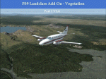
Landclass improvements for the USA, specialy the western part of the USA:
Colorado, Utah, Yellowstone, part of Idaho, Montana and from LA to Seattle, Bristish Columbia and also some Testscenery's for the eastern part of the USA (Arkansas KHOT and around KLWB).
Update, simplification of scenery and batch (option) installation files.
| Filename: | fs9-lcv2.zip |
| License: | Freeware |
| Added: | 6th March 2015, 17:14:38 |
| Downloads: | 291 |
| Author: | Markus Balz |
| Size: | 4.03 MB |
| Category: Flight Simulator 2004 - Scenery | |
| Mormon Range, Enterprise, Beryl (UT82), Utah, Photo-Scenery |
|
Images related to this file:
File Description:
Mormon Range, Enterprise, Beryl (UT82), Utah, Photo-Scenery (FS9 & FSX)
This scenery covers the area of just north of St. George (KSGU) north along the Mormon Range and Enterprise to Beryl (UT82). It completes the southwestern corner of Utah and paves our way into Nevada. High resolution versions of this scenery for FS9 and FSX (much sharper, but larger and multiple downloads)are available at www.blueskyscenery.com/CNY_South2West6.html . The screenies are taken from the high-res versions, so expect this version to be slightly more blurry.
Thanks to Joop Mak for providing a custom AFCADs that correct airport layouts so that they align with the photo-textures! They are available at www.blueskyscenery.com/AFCADs.html . YourDonation@Work: Dedicated to Jean Pierre, Konrad and Juan.
| Filename: | cny_south2west6_2010_lr.zip |
| License: | Freeware, limited distribution |
| Added: | 27th March 2010, 11:38:48 |
| Downloads: | 1,356 |
| Author: | Gottfried Razek, blueskyscenery.com |
| Size: | 97.45 MB |
| Category: Flight Simulator 2004 - Scenery | |
| Bryce Canyon National Park (KBCE), Utah, Photo-Scenery |
|
Images related to this file:
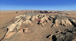
File Description:
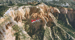
Bryce Canyon National Park (KBCE), Utah, Photo-Scenery (FS9 & FSX)
Despite its name, Bryce Canyon is not actually a canyon that was formed by a river, but rather a giant natural cliff shaped through erosion by wind, water, and ice. Bryce is distinctive due to its geological formations, delicate and colorful pinnacles called hoodoos that are up to 200ft high. The bizarre forms and red, orange and white colors of the rocks provide spectacular views. Unfortunately the hoodoos are too small for the elevation mesh in flight simulator. But you can enjoy the colors and shape of the cliffs. The cliffs in main region of the park, just south of the airport are partly covered
by snow. But on the southern and western part of the plateau you can enjoy them free of snow. Bryce Canyon is named after the Mormon pioneer Ebenezer Bryce who settled in this area in the 1850s. It was designated as a national park in 1928.
Bryce Canyon Airport (KBCE) just handles small aircraft on a daily basis. But is was actually built to handle larger aircraft in case of emergency. And so on Oct.6th 2000 an American Airlines MD-82 from Denver to Los Angeles made a successful emergency landing after reporting smoke in the cockpit and a loss of cabin pressure.
High resolution versions of this scenery for FS9 and FSX (much sharper, but larger and multiple downloads)are available at www.blueskyscenery.com/CNY_South2West4.html . The screenies are taken from the high-res versions, so expect this version to be slightly more blurry. Thanks to Joop Mak for providing a custom AFCADs that correct airport layouts so that they align with the photo-textures! They are available here: www.blueskyscenery.com/AFCADs.html . YourDonation@Work: Dedicated to Michael, Pat and Keith.
| Filename: | cny_south2west4_2010_lr.zip |
| License: | Freeware, limited distribution |
| Added: | 7th March 2010, 11:17:56 |
| Downloads: | 2,191 |
| Author: | Gottfried Razek, blueskyscenery.com |
| Size: | 96.35 MB |
| Category: Flight Simulator 2004 - Scenery | |
| Kanab (KKNB), Utah/Arizona, Photo-Scenery (FS9 & FSX) |
|
Images related to this file:
File Description:
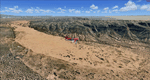
This scenery covers the southwestern part of Grand Staircase-Escalante National Monument. From the air
you can see all the "stairs" from the Pink Cliffs of Bryce Canyon in the north down to the Grey Cliffs,
the White Cliffs and the Vermillion Cliffs just north of Kanab and then the Chocolate Cliffs further south.
Nothwest of Kanab you can fly above beautiful Coral Pink Sand Dunes State Park which features coral-hued
sand dunes located beside red sandstone cliffs. These dunes consist of sand that formed thru erosion of
pink colored Navajo Sandstone surrounding the park and was deposited by wind. To explore the scenery depart
from Kanab Airport (KKNB).
High resolution versions of this scenery for FS9 and FSX (much sharper, but larger and multiple downloads)
are available at www.blueskyscenery.com/CNY_South3West4.html . The screenies are taken from the high-res versions,
so expect this version to be slightly more blurry. Thanks to Joop Mak for providing custom AFCADs that
correct airport layouts so that they align with the photo-textures! They are available at
www.blueskyscenery.com/AFCADs.html . YourDonation@Work: Dedicated to Jesper, Fabrizio and Glen.
| Filename: | cny_south3west4_2010_lr.zip |
| License: | Freeware, limited distribution |
| Added: | 10th March 2010, 22:24:53 |
| Downloads: | 1,498 |
| Author: | Gottfried Razek - blueskyscenery.com |
| Size: | 95.36 MB |
| Category: Flight Simulator 2004 - Scenery | |
| Glen Canyon / Lake Powell, Utah 38m Terrain Mesh |
|
File Description:
USGS SRTM30 1 arc-second, resampled to LOD10 (38.2 meters).
This high-resolution terrain mesh is centered at Glen Canyon
National Recreation Area in south-eastern Utah. Coverage area:
From West -111.6° to West -110.2° and North 36.8° to North 38.0°.
It includes the National Recreation Area with Lake Powell,
Navajo Mountain, the Henry Mountains, parts of Capitol Reef
National Park / Grand Staircase Escalante National Monument,
the town of Page in northern Arizona and surrounding areas.
| Filename: | glen_canyon_srtm30.zip |
| License: | Freeware, limited distribution |
| Added: | 25th January 2004, 20:30:45 |
| Downloads: | 5,412 |
| Author: | Andreas Trawny |
| Size: | 8.31 MB |
| Category: Flight Simulator 2004 - Scenery | |
| Monument Valley, Kayenta (0V7), Utah/Arizona, Photo-Scenery |
|
Images related to this file:
File Description:
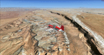
Monument Valley, Kayenta (0V7), Utah/Arizona, Photo-Scenery (FS9 & FSX)
This scenery covers the area from south of the San Juan River down to wonderful Monument Valley and Kayenta, AZ.
It extends my Lake Powell sceneries to the south and brings you another
3.500 sq km in 4.7m/pix quality. To explore the scenery depart from Kayenta (0V7) and head north.
High resolution versions of this scenery for FS9 and FSX (much sharper, but larger and multiple downloads) are available at www.blueskyscenery.com/CNY_South3West.html . The screenies are taken from the high-res versions, so expect this version to be slightly more blurry. YourDonation@Work: Dedicated to Thomas, Don and Eric.
| Filename: | cny_south3west_2010_lr.zip |
| License: | Freeware, limited distribution |
| Added: | 23rd January 2010, 10:45:32 |
| Downloads: | 2,259 |
| Author: | Gottfried Razek - blueskyscenery.com |
| Size: | 93.49 MB |
| Category: Flight Simulator 2004 - Scenery | |
| KCNY Scenery Update |
|
File Description:
This scenery will update the Canyonlands Airport (KCNY) in Utah with fictitous scenery. This is not a real representation of the airport, simply an update I created using the fantastic Runway12 software, to make this airport a little more interesting. You must have the Runway12 scenery libraries and program installed for this scenery to display!
Created By Neil Andrew.
| Filename: | kcny.zip |
| License: | Freeware |
| Added: | 23rd March 2008, 21:21:53 |
| Downloads: | 259 |
| Author: | Neil Andrew |
| Size: | 41 KB |
| Category: Flight Simulator 2004 - Scenery | |
| Comb Ridge, Rock Point (49AZ), Utah/Arizona, Photo-Scenery |
|
Images related to this file:
File Description:
Comb Ridge, Rock Point (49AZ), Utah/Arizona, Photo-Scenery (FS9 & FSX)
This scenery extends my Monument Valley scenery to the east. It covers the area between the San Juan River in the north down to Rock Point, AZ (49AZ). Most of the scenery lies on the Navajo Nation Reservation. It completes the southeastern corner of Utah and paves our way into Colorado.
High resolution versions of this scenery for FS9 and FSX (much sharper, but larger and multiple downloads) are available at www.blueskyscenery.com/CNY_South3West6.html . The screenies are taken from the high-res versions, so expect this version to be slightly more blurry. Thanks to Joop Mak for providing custom AFCADs that correct airport layouts so that they align with the photo-textures! They are available at www.blueskyscenery.com/AFCADs.html . YourDonation@Work: Dedicated to Olivier, Kevin and Ruben.
| Filename: | cny_south3_2010_lr.zip |
| License: | Freeware, limited distribution |
| Added: | 9th April 2010, 21:57:41 |
| Downloads: | 1,343 |
| Author: | Gottfried Razek, blueskyscenery.com |
| Size: | 90.99 MB |
| Category: Flight Simulator 2004 - Scenery | |
| Monument Valley UT25 and Oljato 05UT in Utah USA |
|
Images related to this file:
File Description:
Monument Valley is an impressive sight in south Utah but not, unfortunately, in FS9. Unless you invest in a detailed terrain mesh there are no stacks of rocks reaching for the sky and the lasting overall impression is just of a desert. But I had already downloaded the land textures so I ended up making the Monument Valley UT25 airfield and the nearby Oljato 05UT, which has no buildings of any sort. Maybe I was bored. There is a lodge close to the field with dozens of cabins, but I had insufficient information so this is for the airfield only. The 4,000 feet of new tarmac is aligned 16-34 and is single ended with a large chunk of rock at the southern end; 16 is only used for landing and 34 is only for take off. The runway is not lit. Do not be surprised when you ask to select a runway for take off and FS9 only gives you 16 as a choice, even though you know this is the wrong one. When you accept it FS9 will quickly switch it to 34; apart from a possible sense of humour I have no idea why it does this. Nothing much to say about Oljato. What do you need? You actually don't need Ultimate Terrain as there are other land textures used here, so you will definitely need to have downloaded and installed the land textures "cny_south3west_2010 lr" and "cny_south3west2_2010 lr" by Gottfried Razek, as these land textures showed the runways in the correct positions. Look in the scenery library here or at the other place. A note here about my scenery making. There will not be many more to follow this (unless you count 4 as many) as I am almost at the end of the photos I either took or found for scenery purposes, plus I expect to move on from FS9 at some point during next year.
| Filename: | monument_valley.zip |
| License: | Freeware, limited distribution |
| Added: | 22nd January 2020, 20:13:54 |
| Downloads: | 199 |
| Author: | Roger Wensley |
| Size: | 2.93 MB |
© 2001-2025 AVSIM Online
All Rights Reserved