
Where Flight Simulation Enthusiasts Gather from Around the World!
AVSIM Library - Search Results

| Category: Flight Simulator 2004 - Scenery | |
| TIJ - Tijuana General Abelardo L. Rodriguez Int'l Airport |

|
File Description:
English:
Thank you for downloading Tijuana 2009 scenery by Mach-1 Design Group. The Tijuana international airport is the only airport in Mexico to sit aprroximately 250 feet or 75 meters from the US/Mexico International border. Planes on approach to runway niner actually have to cross into the US before going back into Mexico to land. The airport itself is acutally only 2 miles (4KM) away from downtown Tijuana. This scenery includes accurate and re-done AFCAD along with all parking spots and gates, a newly redone terminal, the Avolar maintenance and base operations hangar. A landclass update for the area is also available, so now you can tell when you cross into Mexico.
Spanish:
Gracias por descargar Tijuana 2009 de Mach-1 Design Group. El aeropuerto internacional de Tijuana es el unico aeropuerto en Mexico que se encuentra a solo 75 metros de la frontera internacional con E.E.U.U. Ademas el aeropuerto se localiza a escazos 4 kilometros del centro de la ciudad. Este escenario incluye todas las salas, una terminal nueva, y el angar de "Avolar".
| Filename: | TIJ__Tijuana_General_Abelardo_L_Rodriguez_Intl_Air.zip |
| License: | Freeware, limited distribution |
| Added: | 29th September 2008, 08:21:03 |
| Downloads: | 3,545 |
| Author: | Mach-1 Design Group |
| Size: | 2.45 MB |
| Category: Flight Simulator 2004 - Scenery | |
| Paso de los Libres Airport (SARL) - Argentina |
|
File Description:
This is very operative Paso de los Libres Airport (SARL), in Paso de los Libres, Provincia de Corrientes, Republica Argentina, with all navaids and his objects in the correct place. This is not photorealistic scenery. ONLY FOR FS2004. Building with SceneGenX version 1.0 Build 54 By Tom Hiscox and some objects of RWY12.
| Filename: | Paso_de_los_Libres_Airport_SARL__Argentina.zip |
| License: | Freeware |
| Added: | 16th May 2006, 00:17:33 |
| Downloads: | 1,227 |
| Author: | carlos maida |
| Size: | 586.34 KB |
| Category: Flight Simulator 2004 - Scenery | |
| San Carlos de Bariloche Airport (SAZS) - Argentina |
|
File Description:
This is very operative S.C. de Bariloche (SAZS), in San Carlos de Bariloche, Provincia de Río Negro, Republica Argentina, with all navaids and the objects
in the correct place. This is not photorealistic scenery. ONLY FOR FS2004. Building with SceneGenX version 1.0 Build 54 By Tom Hiscox and some objects of RWY12.
| Filename: | San_Carlos_de_Bariloche_Airport_SAZS__Argentina.zip |
| License: | Freeware |
| Added: | 1st May 2006, 00:54:57 |
| Downloads: | 3,915 |
| Author: | carlos maida |
| Size: | 927.72 KB |
| Category: Flight Simulator 2004 - Scenery | |
| Argentina ,Valle de Punilla/ Lago San Roque Area, v1.0 |
|
Images related to this file:
File Description:
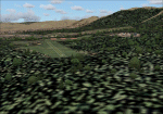
LOD 13 mesh and scenery of the Sierra de Cordoba, Argentina, area. Includes Santa Maria de Punilla and Villa Carlos Paz airstrips as well as a reconfiguration of La Cumbre(SACC) to fit the new mesh.
Roads, rivers and landmarks have been placed to aid VFR pilots
Includes Voicepack modifications for the ICAO identifiers (requires EditVoicepack).
| Filename: | Argentina_Valle_de_Punilla_Lago_San_Roque_Area_v10.zip |
| License: | Freeware, limited distribution |
| Added: | 16th May 2010, 09:57:58 |
| Downloads: | 609 |
| Author: | Alf B. Meier |
| Size: | 7.83 MB |
| Category: Flight Simulator 2004 - Scenery | |
| Sucre, Bolivia New airport Alcantari Int'l Airport - SLAL |
|
File Description:
There is a new airport now Aeropuerto Internacional Alcantari in Yamparaez near Sucre. The old airport Juana Azurduy de Padilla is closed now. It has 8 parking spots.
| Filename: | Sucre_Bolivia_New_airport_Alcantari_Intl_Airport__.zip |
| License: | Freeware |
| Added: | 27th October 2016, 23:22:41 |
| Downloads: | 577 |
| Author: | Stuart John Gilbert II |
| Size: | 3.54 MB |
| Category: Flight Simulator 2004 - Scenery | |
| New Terrain Mesh of the Province of Quebec in LOD09 (1/4) |
|
File Description:
The files in this package contain terrain mesh files of the province of Quebec (N45 to N53) to be used with my Quebec enhanced sceneries for FS2004 (Scenes_du_Quebec_2k4.zip). The public data sources are the Shuttle Radar Topography Mission (SRTM-3, 90m) and the Canadian Digital Elevation Data (CDED - 0.75s/arc - 23m). (QC09_2k4a.zip to QC09_2k4d.zip - 4 parts)
***********************
Les fichiers de ces archives contiennent les donnees d'elevation de terrain (mesh files - lod09), pour FS2004, du territoire de la province de Quebec sous le 53ieme degre de latitude nord. Ils ont ete crees pour etre utilises avec mes nouvelles scenes du Quebec contenues dans Scenes_du_Quebec_2k4.zip. Les donnees sources sont du domaine public et proviennent de la Shuttle Radar Topography Mission (SRTM-3, 90m) et des donnees numerique d'elevation du Canada (DNEC - 0.75s/arc -23 m). (QC09_2k4a.zip to QC09_2k4d.zip - 4 parties)
| Filename: | New_Terrain_Mesh_of_the_Province_of_Quebec_in_LOD09_14.zip |
| License: | Freeware, limited distribution |
| Added: | 27th January 2010, 18:10:18 |
| Downloads: | 8,915 |
| Author: | Gilles Gauthier |
| Size: | 23.76 MB |
| Category: Flight Simulator 2004 - Scenery | |
| New Terrain Mesh of the Province of Quebec in LOD09 (2/4) |
|
File Description:
The files in this package contain terrain mesh files of the province of Quebec (N45 to N53) to be used with my Quebec enhanced sceneries for FS2004 (Scenes_du_Quebec_2k4.zip). The public data sources are the Shuttle Radar Topography Mission (SRTM-3, 90m) and the Canadian Digital Elevation Data (CDED - 0.75s/arc - 23m). (QC09_2k4a.zip to QC09_2k4d.zip - 4 parts)
***********************
Les fichiers de ces archives contiennent les donnees d'elevation de terrain (mesh files - lod09), pour FS2004, du territoire de la province de Quebec sous le 53ieme degre de latitude nord. Ils ont ete crees pour etre utilises avec mes nouvelles scenes du Quebec contenues dans Scenes_du_Quebec_2k4.zip. Les donnees sources sont du domaine public et proviennent de la Shuttle Radar Topography Mission (SRTM-3, 90m) et des donnees numerique d'elevation du Canada (DNEC - 0.75s/arc -23 m). (QC09_2k4a.zip to QC09_2k4d.zip - 4 parties)
| Filename: | New_Terrain_Mesh_of_the_Province_of_Quebec_in_LOD0.zip |
| License: | Freeware, limited distribution |
| Added: | 1st November 2009, 06:47:09 |
| Downloads: | 4,627 |
| Author: | Gilles Gauthier |
| Size: | 27.78 MB |
| Category: Flight Simulator 2004 - Scenery | |
| New Terrain Mesh of the Province of Quebec in LOD09 (3/4) |
|
File Description:
The files in this package contain terrain mesh files of the province of Quebec (N45 to N53) to be used with my Quebec enhanced sceneries for FS2004 (Scenes_du_Quebec_2k4.zip). The public data sources are the Shuttle Radar Topography Mission (SRTM-3, 90m) and the Canadian Digital Elevation Data (CDED - 0.75s/arc - 23m). (QC09_2k4a.zip to QC09_2k4d.zip - 4 parts)
***********************
Les fichiers de ces archives contiennent les donnees d'elevation de terrain (mesh files - lod09), pour FS2004, du territoire de la province de Quebec sous le 53ieme degre de latitude nord. Ils ont ete crees pour etre utilises avec mes nouvelles scenes du Quebec contenues dans Scenes_du_Quebec_2k4.zip. Les donnees sources sont du domaine public et proviennent de la Shuttle Radar Topography Mission (SRTM-3, 90m) et des donnees numerique d'elevation du Canada (DNEC - 0.75s/arc -23 m). (QC09_2k4a.zip to QC09_2k4d.zip - 4 parties)
| Filename: | New_Terrain_Mesh_of_the_Province_of_Quebec_in_LOD0.zip |
| License: | Freeware, limited distribution |
| Added: | 27th January 2010, 18:15:12 |
| Downloads: | 7,495 |
| Author: | Gilles Gauthier |
| Size: | 29.35 MB |
| Category: Flight Simulator 2004 - Scenery | |
| New Terrain Mesh of the Province of Quebec in LOD09 (4/4) |
|
File Description:
The files in this package contain terrain mesh files of the province of Quebec (N45 to N53) to be used with my Quebec enhanced sceneries for FS2004 (Scenes_du_Quebec_2k4.zip). The public data sources are the Shuttle Radar Topography Mission (SRTM-3, 90m) and the Canadian Digital Elevation Data (CDED - 0.75s/arc - 23m). (QC09_2k4a.zip to QC09_2k4d.zip - 4 parts)
***********************
Les fichiers de ces archives contiennent les donnees d'elevation de terrain (mesh files - lod09), pour FS2004, du territoire de la province de Quebec sous le 53ieme degre de latitude nord. Ils ont ete crees pour etre utilises avec mes nouvelles scenes du Quebec contenues dans Scenes_du_Quebec_2k4.zip. Les donnees sources sont du domaine public et proviennent de la Shuttle Radar Topography Mission (SRTM-3, 90m) et des donnees numerique d'elevation du Canada (DNEC - 0.75s/arc -23 m). (QC09_2k4a.zip to QC09_2k4d.zip - 4 parties)
| Filename: | New_Terrain_Mesh_of_the_Province_of_Quebec_in_LOD0.zip |
| License: | Freeware, limited distribution |
| Added: | 27th January 2010, 18:17:08 |
| Downloads: | 7,854 |
| Author: | Gilles Gauthier |
| Size: | 20.94 MB |
| Category: Flight Simulator 2004 - Scenery | |
| New Tacoma Narrows Bridge Addon |
|
File Description:
This file adds the new eastbound second span to the existing Tacoma Narrows Bridge in Tacoma, Washington. Completed in July 2007, it relieves traffic congestion to and from the Olympic Peninsula. No extra software is required to use this; Just install and go. Designed for those who want more than just one bridge that the default scenery has to offer. Instructions included, which were written with novice FS users in mind.
| Filename: | New_Tacoma_Narrows_Bridge_Addon.zip |
| License: | Freeware, limited distribution |
| Added: | 18th June 2008, 15:01:26 |
| Downloads: | 1,261 |
| Author: | Robert A. Diaz |
| Size: | 77.45 KB |
© 2001-2026 AVSIM Online
All Rights Reserved
Privacy Policy |