
Where Flight Simulation Enthusiasts Gather from Around the World!
AVSIM Library - Search Results

| Category: Flight Simulator 2004 - Scenery | |
| Whitefish 58S in Montana US |

|
Images related to this file:
File Description:
I have made this because I downloaded and tried the Glacier Park scenery by Blue Sky Scenery and then discovered that the runway for Whitefish was wrongly aligned and headed off across the adjacent railroad tracks. This would be inconvenient if you had to wait for a train to pass before landing so I fixed that and added a couple of buildings. That's it, nothing more complicated than that. If I find some more airfields in this area with similar problems then I'll do more of the same. Whitefish is 3 or so miles north of Glacier Park International at 3,066 feet ASL and around 35 miles south of the Canadian border. There are no large towns close by; the nearest would be Missoula, which is 90 miles further south.
| Filename: | Whitefish_58S_in_Montana_US.zip |
| License: | Freeware, limited distribution |
| Added: | 23rd May 2010, 02:05:52 |
| Downloads: | 191 |
| Author: | Roger Wensley |
| Size: | 826.52 KB |
| Category: Flight Simulator 2004 - Scenery | |
| The Oregon Coast Scenic Railroad (OCSR) |
|
Images related to this file:
File Description:
The Oregon Coast Scenic Railroad. All aboard! This is a re-creation of the OCSR, which runs from Garibaldi, Oregon along the seashore to Rockaway Beach. It is designed to compliment the Tillamook, Oregon Airport scenery by John McKeon and David "Opa" Marshall (tills47.zip and tillup.zip - available here).
The project utilizes objects from selected EZ and RWY12 libraries as well as the new Railroad Object library by John McKeon (ezrrobjm.zip - also available here). If you have the LAGO FSE program you will be able to hear the Steam Train whistle and the nearby seagulls as files for these sounds are included. This scenery was designed to display properly in the default FS2004 environment. Please unzip to a temporary folder and follow the simple installation instructions. Compiled for your flying enjoyment by David "Opa" Marshall.
| Filename: | ocrs.zip |
| License: | Freeware |
| Added: | 1st February 2010, 11:20:40 |
| Downloads: | 1,317 |
| Author: | David "Opa" Marshall |
| Size: | 3.45 MB |
| Category: Flight Simulator 2004 - AI Flight Plans | |
| Gladiators Complete AI Package |
|
Images related to this file:
File Description:

The members of Military AI Works are proud to bring you the Gladiators Complete AI Package for FS2004. This package depicts VFA-106 which is the United States Navy and United States Marine Corps east coast Hornet and Superhornet fleet replacement squadron. This squadron is used to train new and transitioning F/A-18 pilots and weapon systems operators. This package depicts VFA-106 operations at NAS Oceana as well as the detachments at NAS Key West. As a bonus, this package also depicts the F-5s of VFC-111 stationed at NAS Key West. Credits: Models by Jake Burrus and Nick Black, Repaints by Graham King, Mark Heimer and Lewis Macgruder, FDE/Effects by Mike MacIntyre, Nick Needham, Steve Holland and Henry Tomkiewicz, AFCADs by John Stinstrom and Desmond Burrell, VCPs by Stewart Pearson and Desmond Burrell, Scenery by Johns Stinstrom and Marcel Ritzema
| Filename: | maiw_gladiators.zip |
| License: | Freeware, limited distribution |
| Added: | 6th February 2012, 04:02:23 |
| Downloads: | 1,013 |
| Author: | Desmond Burrell, Military AI Works (MAIW) |
| Size: | 30.28 MB |
| Category: Flight Simulator 2004 - Scenery | |
| Talkeetna Village AK44 in Alaska, home of Don Sheldon's Talkeetna Air Service |
|
Images related to this file:
File Description:
Talkeetna is around 75 miles north of Anchorage in Alaska on the east shore of the Susitna River. The town is where Don Sheldon got off the train in 1938, and where, ten years later, he started Talkeetna Air Services. There are two airfields in Talkeetna, PATK with its long asphalt runway and Talkeetna Village AK44 in the middle of the town. This is AK44; the default FS version with Ultimate Terrain installed had the runway half in the river, but there is still space for the 900 feet of runway that is described in the book "Wager With The Wind" that tells Don's story. The result is a step back in time to 1973, when the second hangar was built. If you also want to install PATK do a search. I have partially populated the village with cabins, and UT is probably required for the river to be there; I haven't tested this without it.
| Filename: | talkeetna_village.zip |
| License: | Freeware |
| Added: | 4th February 2010, 01:24:40 |
| Downloads: | 560 |
| Author: | Roger Wensley |
| Size: | 3.67 MB |
| Category: Flight Simulator 2004 - Scenery | |
| Just For Fun 1 |
|
File Description:
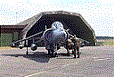
Here's a little "just for fun" addition to make your GA flying in California a bit more interesting. Moffett Field, Mountain View, CA is a major landmark in the San Francisco Bay area. It is my understanding that NASA now controls this property and may convert all or a part of it to an Aviation Musuem. Microsoft elected to include the two ENORMOUS hangers that apparently were once used by the Navy to store Blimps and train crews. This scenery has the Goodyear Blimp (by Bill Lyons) doing touch and goes - taking off from inside of and landing in one of the immense hangers! Perhaps not very realistic but great fun to watch! Everything is included plus a recommendation to add John Townsend's great Hangar One scenery to the same airport. Works in FS2004 only. Just unzip to a Temp folder and read the simple installation instructions.
Created by David "Opa" Marshall - Plano, Texas
| Filename: | just4fun1.zip |
| License: | Freeware |
| Added: | 29th June 2004, 03:00:05 |
| Downloads: | 2,071 |
| Author: | David Marshall |
| Size: | 193 KB |
| Category: Flight Simulator 2004 - Scenery | |
| Niederrhein - Laarbruch 2009 v0.8 |
|
Images related to this file:
File Description:
Along the Dutch border, four airbases were built. All four of them had about the same shape and dimensions. All four of them were RAF bases, operated by RAF Germany, serving in the cold war. Slowly, one by one, they either closed or were converted for other uses. Geilenkirchen became a NATO base with AWACS aircraft operating, Wildenrath closed in 1990 to be converted into a Siemens train testing center. Brueggen closed in 2002 and I think it is now being used as army base. Laarbruch closed in 1999, to reopen as a civil airfield in May 2003.
------------
This scenery is a kind of beta version, I kindly ask you to read all about that in the readme word document. This scenery features all new 3D objects, including photorealistic elements. In my opinion this scenery captures the EDLV - ETUL atmosphere very well. The airport is located near Weeze in Germany.
Please forget about my previous EDLV versions - this one is way better.
| Filename: | edlv_niederrhein.zip |
| License: | Freeware |
| Added: | 3rd March 2010, 03:36:30 |
| Downloads: | 2,389 |
| Author: | Nils Lips |
| Size: | 5.63 MB |
| Category: Flight Simulator 2004 - Scenery | |
| Wakefield riverfront in Quebec Canada |
|
Images related to this file:
File Description:
The village of Wakefield is 18 miles northwest of Ottawa on the west shore of the Gatineau River, and I seem to have been flying north up that river from Rock cliffe for years, past the village in a bend of the river just a few miles north of Cascades float base. It is where the tourist steam train goes through, and by "through" I mean that literally as the tracks are at the side of the main street, and one of the things it goes past is the Black Sheep Inn which hosts Canadian musical groups and individuals at the weekends. Though the radio in Ottawa uses the name in English it is actually and visibly called "Mouton Noir" on the sign. There is no airfield, and no float base. There aren't even all the buildings that are on the riverfront as it stretches further south and north. There is a public dock where you can tie up. Apart from the fact that the idea caught my fancy one afternoon outside the Mouton Noir I really can't think why I made this.
| Filename: | wakefieldriverfront.zip |
| License: | Freeware, limited distribution |
| Added: | 1st May 2010, 00:39:24 |
| Downloads: | 402 |
| Author: | Roger Wensley |
| Size: | 11.58 MB |
| Category: Flight Simulator 2004 - Scenery | |
| Legnano scenery - Italy |
|
Images related to this file:
File Description:
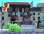
Homage to my town, scenery built mainly with existing objects, buildings by sintax and few experiments by GMax. It DOES NOT include any airport, but represents some pictures of Legnano town
Informations: Legnano is a town in north of Italy (approx 25 kmt NW Milan, ref coordinates N45 35.98 E8 54.59), reachable from Casorezzo ultralight airport (closest one) or all the near others of Milan area.
Here was done in 1176 the historical fight of the Alliance Lombarda's city-states against Federico Barbarossa German imperator. Legnano is also well known for his metallurgical and textile industries story.
Contents: rev.1 : down town square with municipal Palazzo Malinverni and S. Magno basilica, skyscraper, one of Olona river's bridges, G. Mari football stadium, Alberto da Giussano circus with related monument, encircled by the eight quarter's flags, F. Tosi and Manifattura industrial buildings, Rail station, external parking and glass building
rev.2 : Courthouse building with Teresa's face bronze statue and some more buidings, Palio hystorical figurants inside the stadium, Carroccio and Alberto da Giussano rider, Small goods train on railroad; S. Magno belltower reviewed, red sky-lights on top of skyscraper and chimney, Chimney smoke
| Filename: | legnano_v2.zip |
| License: | Freeware |
| Added: | 27th March 2011, 02:55:40 |
| Downloads: | 638 |
| Author: | Aldo Della Vedova |
| Size: | 6.88 MB |
| Category: Flight Simulator 2004 - Scenery | |
| OSM World: Western Europe |
|
Images related to this file:
File Description:

Read Installation instructions carefully, this is a complex scenery package!
This package includes a "Dev Kit" should you wish to expand it to other areas! Please contact me if you wish to do so! This is community effort! If we all contribute, we will hopefully have the entire world covered one day!
Welcome to OSM World: Western Europe! This is a vector data scenery package covering the western European area. Coastlines, Rivers, lakes, roads, railways, and power lines with detail never before seen! All in an autogen-compatible density! You can see roundabouts, train terminals, harbor areas in a resolution of a point every 10 meters. At this same resolution a vectorial city class places residential (in small and big building variations, depending on surface area) and industrial areas exactly where they are supposed to be. This gives the city areas a resolution far superior to the capacity of FS-2004 default landclass bitmaps, limited to approximately 1 Km x 1 Km squares. OSM World: Western Europe will even give you small roads leading to small towns (even a few houses across)! From big highway intersections, including ramps, to the tiniest rural pathways covering the entire western area! Wherever in Western Europe you fly, there is something to see!
| Filename: | osm_world_western_europe.zip |
| License: | Freeware |
| Added: | 13th October 2014, 00:18:39 |
| Downloads: | 4,051 |
| Author: | Mario Noriega |
| Size: | 274.75 MB |
| Category: Flight Simulator 2004 - Scenery | |
| CNZ3 - Chatham-Kent - Ontario, Canada V1 |
|
Images related to this file:
File Description:
This is partly part of the Small Ontario Fields series. The airport ICAO was changed from CNZ3 to CYCK in November 2012; I have left it as it was. The runway too remains as it was a few years ago. Chatham is located 50 miles east of Detroit and 150 miles southwest of Toronto, between Lake St. Clair and Lake Erie, and the airfield is southeast of the town. There is a single asphalt runway 5,000 feet long and 75 feet wide, aligned 05/23 in FS9 but in fact in real life now 06/24 due to the wandering magnetic north. The apron is on the northern side of the runway at the eastern end, with added taxiways to cater for newer hangars wearing identical colour schemes. There is fuel, runway lighting, some taxiway lights, visitor parking on the grass, and plane maintenance in the large hangar beside the small terminal building on the north side of the apron. There is a train station in the middle of the town, and no scheduled flights to the airport that is 8 miles away; these two facts may be connected. Ditches along the road and around much of the airfield provide separation, which is why the fences are not continuous. If you are on the runway and find your path to the apron blocked by another plane that is stationary at the hold short, continue past the first turnoff to the threshold markers and turn off the runway and wait. The AI plane will then taxi out and you will have a clear path.
| Filename: | chatham_kent_cnz3_v1.zip |
| License: | Freeware, limited distribution |
| Added: | 27th August 2015, 21:02:59 |
| Downloads: | 332 |
| Author: | Roger Wensley |
| Size: | 10.22 MB |
© 2001-2025 AVSIM Online
All Rights Reserved