
Where Flight Simulation Enthusiasts Gather from Around the World!
AVSIM Library - Search Results

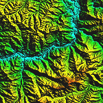
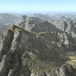
| Category: Flight Simulator 2004 - Scenery | |
| Himalayas LOD9 Base Mesh, Volume 3 - Southwestern Ranges |

|
Images related to this file:
File Description:

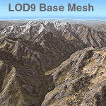
Detailed terrain mesh of the Southwestern Himalayan Ranges, N28-37 E78-82. The files in this package are based on Shuttle Radar (SRTM) Version 2 data but with many of the void areas, especially the most significant sections, filled with elevation data generated from topographic maps by Jonathan de Ferranti. While Jonathan's work is unrelated to flight simulation he kindly gave me permission to compile his data for use in FS. The result is a wonderful improvement in detail and accuracy over any existing mesh file, freeware or commercial, based on SRTM or DTED data alone.
Due to the large area of the Himalayas I've compiled the source data as two separate series: the "Himalayan Peaks" series covers prominent mountains and ranges in higher detail and locally overrides any existing LOD9 terrain mesh. In addition, the LOD9 "base mesh" series, with LOD8 and LOD7 "buffer" mesh files, covering the entire Himalayas, is meant for those who do not yet have an add-on terrain mesh of these beautiful mountains.
| Filename: | fs_him_b3.zip |
| License: | Freeware, limited distribution |
| Added: | 30th May 2010, 10:00:26 |
| Downloads: | 155,792 |
| Author: | Holger Sandmann, Jonathan de Ferranti |
| Size: | 62.16 MB |
| Category: Flight Simulator 2004 - Scenery | |
| Himalayas LOD9 Base Mesh, Volume 4 - Kashmir and Jammu |
|
File Description:
Detailed terrain mesh of the Kashmir and Jammu Ranges, N30-39 E76-78. The files in this package are based on Shuttle Radar (SRTM) Version 2 data but with many of the void areas, especially the most significant sections, filled with elevation data generated from topographic maps by Jonathan de Ferranti. While Jonathan's work is unrelated to flight simulation he kindly gave me permission to compile his data for use in FS. The result is a wonderful improvement in detail and accuracy over any existing mesh file, freeware or commercial, based on SRTM or DTED data alone.
Due to the large area of the Himalayas I've compiled the source data as two separate series: the "Himalayan Peaks" series covers prominent mountains and ranges in higher detail and locally overrides any existing LOD9 terrain mesh. In addition, the LOD9 "base mesh" series, with LOD8 and LOD7 "buffer" mesh files, covering the entire Himalayas, is meant for those who do not yet have an add-on terrain mesh of these beautiful mountains.
| Filename: | fs_him_b4.zip |
| License: | Freeware, limited distribution |
| Added: | 22nd February 2006, 20:32:50 |
| Downloads: | 7,489 |
| Author: | Holger Sandmann, Jonathan de Ferranti |
| Size: | 29.24 MB |
| Category: Flight Simulator 2004 - Scenery | |
| Himalayas LOD9 Base Mesh, Volume 5 - Hindu Kush and Pamir |
|
Images related to this file:
File Description:
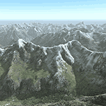
Detailed terrain mesh of the Hindu Kush and Pamir Ranges, N32-40 E70-76. The files in this package are based on Shuttle Radar (SRTM) Version 2 data but with many of the void areas, especially the most significant sections, filled with elevation data generated from topographic maps by Jonathan de Ferranti. While Jonathan's work is unrelated to flight simulation he kindly gave me permission to compile his data for use in FS. The result is a wonderful improvement in detail and accuracy over any existing mesh file, freeware or commercial, based on SRTM or DTED data alone.
Due to the large area of the Himalayas I've compiled the source data as two separate series: the "Himalayan Peaks" series covers prominent mountains and ranges in higher detail and locally overrides any existing LOD9 terrain mesh. In addition, the LOD9 "base mesh" series, with LOD8 and LOD7 "buffer" mesh files, covering the entire Himalayas, is meant for those who do not yet have an add-on terrain mesh of these beautiful mountains.
| Filename: | fs_him_b5.zip |
| License: | Freeware, limited distribution |
| Added: | 29th May 2010, 08:57:29 |
| Downloads: | 7,588 |
| Author: | Holger Sandmann, Jonathan de Ferranti |
| Size: | 85.72 MB |
| Category: Flight Simulator 2004 - Scenery | |
| Alps LOD10 Topo Mesh - Switzerland and France |
|
Images related to this file:
File Description:
Yet another terrain mesh package of the European Alps? Well, this one is different in that it is NOT primarily based on the Shuttle Radar (SRTM) data with their incomplete coverage of prominent peaks and ridges. Instead, most of the source data for this project were developed over many months by Jonathan de Ferranti using detailed topographic maps. While Jonathan's work is unrelated to flight simulation he kindly gave me permission to compile his data for use in FS. The result is a wonderful improvement in detail and accuracy over any existing SRTM- or DTED-based mesh file, freeware or commercial (a link to an extensive set of screenshot comparisons is included in the read-me file).
I've compiled the source data at LOD10 (38-m) grid resolution because the coverage area is smaller than most existing mesh files. Thus, anyone can use these files without having to first uninstall their current mesh set. Also included are LOD9 and LO8 buffer mesh files. Note: if you own Switzerland Professional with its high-resolution terrain mesh then you don't need this package, at least not the Switzerland files!
| Filename: | alpsw_fe.zip |
| License: | Freeware, limited distribution |
| Added: | 30th May 2010, 09:51:03 |
| Downloads: | 58,928 |
| Author: | Holger Sandmann, Jonathan de Ferranti |
| Size: | 50.03 MB |
| Category: Flight Simulator 2004 - Scenery | |
| Himalayas LOD9 Base Mesh, Volume 1 - Southeastern Ranges |
|
Images related to this file:
File Description:

Detailed terrain mesh of the Southeastern Himalayan Ranges, N26-32 E90-98. The files in this package are based on Shuttle Radar (SRTM) Version 2 data but with many of the void areas, especially the most significant sections, filled with elevation data generated from topographic maps by Jonathan de Ferranti. While Jonathan's work is unrelated to flight simulation he kindly gave me permission to compile his data for use in FS. The result is a wonderful improvement in detail and accuracy over any existing mesh file, freeware or commercial, based on SRTM or DTED data alone.
Due to the large area of the Himalayas I've compiled the source data as two separate series: the "Himalayan Peaks" series covers prominent mountains and ranges in higher detail and locally overrides any existing LOD9 terrain mesh. In addition, a LOD9 "base mesh" series, with LOD8 and LOD7 "buffer" mesh files, covering the entire Himalayas, is meant for those who do not yet have an add-on terrain mesh of these beautiful mountains.
| Filename: | fs_him_b1.zip |
| License: | Freeware, limited distribution |
| Added: | 29th May 2010, 09:01:26 |
| Downloads: | 10,272 |
| Author: | Holger Sandmann, Jonathan de Ferranti |
| Size: | 71.82 MB |
| Category: Flight Simulator 2004 - Scenery | |
| "Himalayan Peaks" LOD10 Mesh, Volume 8 - Tirich Mir and Pamir |
|
Images related to this file:
File Description:
Highly detailed terrain mesh of the Tirich Mir and Pamir areas, N36-39 E71-74. The files in this package are based on Shuttle Radar (SRTM) Version 2 data but with many of the void areas, especially the most significant sections, filled with elevation data generated from topographic maps by Jonathan de Ferranti. While Jonathan's work is unrelated to flight simulation he kindly gave me permission to compile his data for use in FS. The result is a wonderful improvement in detail and accuracy over any existing mesh file, freeware or commercial, based on SRTM or DTED data alone.
Due to the large area of the Himalayas I've compiled the source data as two separate series: the "Himalayan Peaks" series covers prominent mountains and ranges in higher detail and locally overrides any existing LOD9 terrain mesh. In addition, a LOD9 "base mesh" series covering the entire Himalayas will be available for those who do not yet have an add-on terrain mesh of these beautiful mountains.
| Filename: | fs_him_08.zip |
| License: | Freeware, limited distribution |
| Added: | 29th May 2010, 08:52:47 |
| Downloads: | 9,084 |
| Author: | Holger Sandmann, Jonathan de Ferranti |
| Size: | 47.94 MB |
| Category: Flight Simulator 2004 - Scenery | |
| "Himalayan Peaks" LOD10 Mesh, Volume 6 - Jammu and Kashmir |
|
Images related to this file:
File Description:
Highly detailed terrain mesh of the Jammu and Kashmir areas, N31-36 E76-78. The files in this package are based on Shuttle Radar (SRTM) Version 2 data but with many of the void areas, especially the most significant sections, filled with elevation data generated from topographic maps by Jonathan de Ferranti. While Jonathan's work is unrelated to flight simulation he kindly gave me permission to compile his data for use in FS. The result is a wonderful improvement in detail and accuracy over any existing mesh file, freeware or commercial, based on SRTM or DTED data alone.
Due to the large area of the Himalayas I've compiled the source data as two separate series: the "Himalayan Peaks" series covers prominent mountains and ranges in higher detail and locally overrides any existing LOD9 terrain mesh. In addition, a LOD9 "base mesh" series covering the entire Himalayas will be available for those who do not yet have an add-on terrain mesh of these beautiful mountains.
| Filename: | fs_him_06.zip |
| License: | Freeware, limited distribution |
| Added: | 29th May 2010, 08:55:43 |
| Downloads: | 9,635 |
| Author: | Holger Sandmann, Jonathan de Ferranti |
| Size: | 52.19 MB |
| Category: Flight Simulator 2004 - Scenery | |
| "Himalayan Peaks" LOD10 Mesh, Volume 7 - K2 and Karakoram |
|
Images related to this file:
File Description:
Highly detailed terrain mesh of the Karakoram area, N35-37 E73-77. The files in this package are based on Shuttle Radar (SRTM) Version 2 data but with many of the void areas, especially the most significant sections, filled with elevation data generated from topographic maps by Jonathan de Ferranti. While Jonathan's work is unrelated to flight simulation he kindly gave me permission to compile his data for use in FS. The result is a wonderful improvement in detail and accuracy over any existing mesh file, freeware or commercial, based on SRTM or DTED data alone.
Due to the large area of the Himalayas I've compiled the source data as two separate series: the "Himalayan Peaks" series covers prominent mountains and ranges in higher detail and locally overrides any existing LOD9 terrain mesh. In addition, a LOD9 "base mesh" series covering the entire Himalayas will be available for those who do not yet have an add-on terrain mesh of these beautiful mountains.
| Filename: | fs_him_07.zip |
| License: | Freeware, limited distribution |
| Added: | 30th May 2010, 09:56:27 |
| Downloads: | 9,450 |
| Author: | Holger Sandmann, Jonathan de Ferranti |
| Size: | 38.58 MB |
| Category: Flight Simulator 2004 - Scenery | |
| Alps LOD10 Topo Mesh - Austria and Italy |
|
Images related to this file:
File Description:
Yet another terrain mesh package of the European Alps? Well, this one is different in that it is NOT primarily based on the Shuttle Radar (SRTM) data with their incomplete coverage of prominent peaks and ridges. Instead, most of the source data for this project were developed over many months by Jonathan de Ferranti using detailed topographic maps. While Jonathan's work is unrelated to flight simulation he kindly gave me permission to compile his data for use in FS. The result is a wonderful improvement in detail and accuracy over any existing SRTM- or DTED-based mesh file, freeware or commercial (a link to an extensive set of screenshot comparisons is included in the read-me file).
I've compiled the source data at LOD10 (38-m) grid resolution because the coverage area is smaller than most existing mesh files. Thus, anyone can use these files without having to first uninstall their current mesh set. Also included are LOD9 and LO8 buffer mesh files. Note: if you own Austria Professional 2004 with its 1:50,000 scale terrain mesh then you don't need this package!
| Filename: | alpse_fe.zip |
| License: | Freeware, limited distribution |
| Added: | 30th May 2010, 09:46:58 |
| Downloads: | 62,900 |
| Author: | Holger Sandmann, Jonathan de Ferranti |
| Size: | 73.32 MB |
| Category: Flight Simulator 2004 - Scenery | |
| Victoria, Canada area scenery |
|
File Description:
This is a complete upgrade of vicenh05, Victoria, Canada area scenery for FS9. New in this version: automated installer and configurator from Ken Peters; several detailed models including the Empress Hotel, the Legislature, the Regent Hotel and the Johnson St. Bridge; greatly enhanced Inner Harbour; many generic buildings representing buildings throughout the area; 7 new small airfields with sloping runways; seven new floatplane bases (owners of Vancouver+ get extensive floatplane traffic in local liveries); 7 new heliports (Vancouver+ users get additional heli AI traffic) and a myriad of minor fixes and improvements. Included from previous versions are revised shorelines, landclass and 19m mesh and buffer meshes for South-Eastern Vancouver Island; boat docks with static boats, seaplane docks and terminal buildings for Harbour Air, Kenmore Air and West Coast Air; piers, buildings, breakwater and other components of the Ogden Point Terminal; dock, service building and pilot boats of the Pacific Pilotage Authority; Odgen Point Cafe and Dive Shop; marine navigational lights for Victoria Harbour and area, including Esquimalt harbour and Oak Bay; antennae location corrections for the area; AFCADs included: Land based (CML2), Floatplane (CAB3, CAP5, CAP8, CAV8, CAW7, CAX6, CMAP, CYWH), Heli (CAL7, CBF5, CBF7, CBK8, CBW7, CBW9, CBZ7, CMBH); AI craft models and repaints (Cruise ships are repaints of Asuka model by Mitsuya Hamaguchi: MS Amsterdam of the Holland America Line travelling from Victoria to Vancouver, MS Summit of the Celebrity Cruise Line travelling from Seattle to Victoria); S-61 Sea-King helicopter in Helijet colours; Pacific Pilot custom vessel working from the Pilot dock; 22, 30 and 40 foot vessels plying the harbour and nearby Straight of Juan de Fuca. Effects included for lights, water, smoke effects. Many flights are offered, including two flights for owners of the Aerosoft Beaver (not required). Ultimate Terrain compatible (not required). Users of Misty Fjords will also get additional cruise ship traffic: the Island Princess and the Volendam alternating with the Amsterdam and Summit. Fully compatible with Don Grovestine's excellent CYYJ 2007. Replaces viflat.zip, ve4_tr1.zip, vicenh02.zip, vicenh03.zip, vicenh04.zip and vicenh05.zip. Detailed documentation included. By Jon Patch and Holger Sandmann.
| Filename: | Victoria_Canada_area_scenery.zip |
| License: | Check within download |
| Added: | 29th January 2010, 21:22:09 |
| Downloads: | 5,274 |
| Author: | Jon Patch and Holger Sandmann |
| Size: | 24.28 MB |
© 2001-2025 AVSIM Online
All Rights Reserved