
Where Flight Simulation Enthusiasts Gather from Around the World!
AVSIM Library - Search Results

| Category: Flight Simulator 2002 - Scenery | |
| Quebec Terrain Mesh (1/5) |

|
File Description:
Re-uploaded file. New resolution (76m) terrain mesh of province of Quebec, Canada, covering longitude W58 to W80 and latitude N45 to N53. This resolution terrain mesh is based on SRTM-3 (90m) digital elevation models, resampled to LOD of 09 (76m). Five parts: qclod09a.zip, qclod09b.zip, qclod09c.zip, qclod09d.zip, qclod09e.zip.
| Filename: | qclod09a.zip |
| License: | Freeware, limited distribution |
| Added: | 11th May 2010, 21:26:59 |
| Downloads: | 6,749 |
| Author: | Gilles Gauthier |
| Size: | 18.25 MB |
| Category: Flight Simulator X - Scenery | |
| Labrador Landscape, Canada - 2/2 |
|
File Description:
Labrador (Province of Newfoundland and Labrador, Canada) elevation data (mesh-Lod10), land cover around airport, water polygons, rivers, stream lines, lanes and shorelines
| Filename: | labrador_landscape_2de2.zip |
| License: | Freeware, limited distribution |
| Added: | 24th May 2010, 11:36:42 |
| Downloads: | 2,339 |
| Author: | Gilles Gauthier |
| Size: | 58.33 MB |
| Category: Flight Simulator X - Scenery | |
| Nunavik Landscape - Province of Quebec, Canada - 2/4 |
|
File Description:
Nunavik (Ungava peninsula) elevation data (mesh-Lod10), land cover around airport, water polygons, rivers, stream lines and lanes - Province of Quebec, Canada. 4 files.
| Filename: | nunavik_landscape_2de4.zip |
| License: | Freeware, limited distribution |
| Added: | 28th March 2010, 19:43:13 |
| Downloads: | 2,177 |
| Author: | Gilles Gauthier |
| Size: | 51.89 MB |
| Category: Flight Simulator X - Scenery | |
| Nunavik Landscape - Province of Quebec, Canada - 3/4 |
|
File Description:
Nunavik (Ungava peninsula) elevation data (mesh-Lod10), land cover around airport, water polygons, rivers, stream lines and lanes - Province of Quebec, Canada. 4 files.
| Filename: | nunavik_landscape_3de4.zip |
| License: | Freeware, limited distribution |
| Added: | 28th March 2010, 19:43:50 |
| Downloads: | 2,260 |
| Author: | Gilles Gauthier |
| Size: | 63.38 MB |
| Category: Flight Simulator X - Scenery | |
| Nunavik Landscape - Province of Quebec, Canada - 4/4 |
|
File Description:
Nunavik (Ungava peninsula) elevation data (mesh-Lod10), land cover around airport, water polygons, rivers, stream lines and lanes - Province of Quebec, Canada. 4 files.
| Filename: | nunavik_landscape_4de4.zip |
| License: | Freeware, limited distribution |
| Added: | 28th March 2010, 19:44:23 |
| Downloads: | 2,494 |
| Author: | Gilles Gauthier |
| Size: | 46.98 MB |
| Category: Flight Simulator 2004 - Scenery | |
| Sion Hospital for FS2004 and Suisse 2004 |
|
Images related to this file:
File Description:
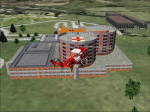
Sion Hospital (Switzerland) near the airport of Sion (LSGS). To be used with Suisse 2004 sceneries or alone. Landable deck. Reload after hack. Had more than 5000 downloads.
| Filename: | ch04hcs4.zip |
| License: | Freeware |
| Added: | 18th April 2010, 14:42:12 |
| Downloads: | 962 |
| Author: | Daniel Gauthier |
| Size: | 1.31 MB |
| Category: Flight Simulator 2004 - Aircraft Repaints, Textures and Modifications | |
| Civil Air Transport (CAT) Douglas DC-6B |
|
Images related to this file:
File Description:
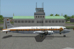
Repaint of the excellent DC-6B model by Greg Pepper & Tom Gibson (www.calclassic.com). It represent a real airplane : the B-1006 from CAT (Civil Air Transport) the company active in South East Asia and China that will later become Air America.
| Filename: | dc6b-cat.zip |
| License: | Freeware |
| Added: | 22nd April 2010, 13:36:41 |
| Downloads: | 247 |
| Author: | Daniel Gauthier |
| Size: | 3.54 MB |
| Category: Flight Simulator 2004 - Aircraft Repaints, Textures and Modifications | |
| Air America Douglas DC-6B |
|
Images related to this file:
File Description:
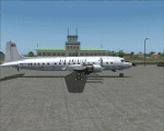
Repaint of the excellent DC-6B model by Greg Pepper & Tom Gibson (www.calclassic.com). It represent a real airplane from Air America.
| Filename: | dc6b-aa.zip |
| License: | Freeware |
| Added: | 22nd April 2010, 13:37:26 |
| Downloads: | 404 |
| Author: | Daniel Gauthier |
| Size: | 3.79 MB |
| Category: Flight Simulator 2004 - Scenery | |
| New Terrain Mesh of the Province of Quebec in LOD09 (3/4) |
|
File Description:
The files in this package contain terrain mesh files of the province of Quebec (N45 to N53) to be used with my Quebec enhanced sceneries for FS2004 (Scenes_du_Quebec_2k4.zip). The public data sources are the Shuttle Radar Topography Mission (SRTM-3, 90m) and the Canadian Digital Elevation Data (CDED - 0.75s/arc - 23m). (QC09_2k4a.zip to QC09_2k4d.zip - 4 parts)
***********************
Les fichiers de ces archives contiennent les donnees d'elevation de terrain (mesh files - lod09), pour FS2004, du territoire de la province de Quebec sous le 53ieme degre de latitude nord. Ils ont ete crees pour etre utilises avec mes nouvelles scenes du Quebec contenues dans Scenes_du_Quebec_2k4.zip. Les donnees sources sont du domaine public et proviennent de la Shuttle Radar Topography Mission (SRTM-3, 90m) et des donnees numerique d'elevation du Canada (DNEC - 0.75s/arc -23 m). (QC09_2k4a.zip to QC09_2k4d.zip - 4 parties)
| Filename: | qc09_2k4c.zip |
| License: | Freeware, limited distribution |
| Added: | 27th January 2010, 18:15:12 |
| Downloads: | 7,485 |
| Author: | Gilles Gauthier |
| Size: | 29.35 MB |
| Category: Flight Simulator 2004 - Scenery | |
| New Terrain Mesh of the Province of Quebec in LOD09 (4/4) |
|
File Description:
The files in this package contain terrain mesh files of the province of Quebec (N45 to N53) to be used with my Quebec enhanced sceneries for FS2004 (Scenes_du_Quebec_2k4.zip). The public data sources are the Shuttle Radar Topography Mission (SRTM-3, 90m) and the Canadian Digital Elevation Data (CDED - 0.75s/arc - 23m). (QC09_2k4a.zip to QC09_2k4d.zip - 4 parts)
***********************
Les fichiers de ces archives contiennent les donnees d'elevation de terrain (mesh files - lod09), pour FS2004, du territoire de la province de Quebec sous le 53ieme degre de latitude nord. Ils ont ete crees pour etre utilises avec mes nouvelles scenes du Quebec contenues dans Scenes_du_Quebec_2k4.zip. Les donnees sources sont du domaine public et proviennent de la Shuttle Radar Topography Mission (SRTM-3, 90m) et des donnees numerique d'elevation du Canada (DNEC - 0.75s/arc -23 m). (QC09_2k4a.zip to QC09_2k4d.zip - 4 parties)
| Filename: | qc09_2k4d.zip |
| License: | Freeware, limited distribution |
| Added: | 27th January 2010, 18:17:08 |
| Downloads: | 7,843 |
| Author: | Gilles Gauthier |
| Size: | 20.94 MB |
© 2001-2025 AVSIM Online
All Rights Reserved