
Where Flight Simulation Enthusiasts Gather from Around the World!
AVSIM Library - Search Results

| Category: Prepar3D V1-4 - Original Aircraft | |
| Random Flight Database 2.3.0 |

|
File Description:
Random Flight Database is a simple and easy to use application.
It will allow you to randomly choose a flight according to your criteria.
A default database is already included, but also the possibility for each user to create his own database.
But it's not all, you can also extract the flights of the day for an airport, or extract flights on a full week.
Windows Only
2.3.0
Replace winter by summer 2019 :
Air Do
Alaska Airlines
All Nippon Airways
Amakusa Airlines
ANA Cargo
ANA Wings
FlyOne
Ibex Airlines
Peach Aviation
PenAir
Skymark Airlines
Solaseed Air
Starflyer
TAP Air Portugal
TAP Express
TUI fly Belgium
Vanilla Air
Wamos Air
Install : Execute .exe
Contact [email protected]
https://mikoulprostgrandprix.wixsite.com/randomflightdatabase
Other install : execute the shortcut "Check Update Random Flight Database"
Do not hesitate to send me bugs, or proposals. Thanks
| Filename: | Random_Flight_Database_230.zip |
| License: | Freeware |
| Added: | 27th September 2019, 17:07:27 |
| Downloads: | 96 |
| Author: | mikoulprostgrandprix |
| Size: | 78.36 MB |
| Category: Flight Simulator 2002 - Scenery | |
| Seattle Tacoma Intern. Airport Replacement Cargo Scenery |
|
File Description:
This scenery is a replacement for the Microsoft default cargo areas at KSEA(Seattle Tacoma International). I was very dissapointed with the original scenery because the hangers seemed to be placed in a random form without consideration to placement or proximity to other hangers as well as many just bunched together. This scenery I hope gives new life to KSEA. I have added some trees along the edges of the cargo areas to frame it. Whats new to this scenery???.....There is new GA facility at the south end of the field, a new NWA hanger and a revised Alaska Airlines hanger as well. The North cargo area host a revised KSEA control tower, Fire Station, Fed-Ex facility as well as a better over all feel of what a cargo area at a major airport should feel like.
| Filename: | Seattle_Tacoma_Intern_Airport_Replacement_Cargo_Sc.zip |
| License: | Freeware |
| Added: | 22nd April 2003, 20:38:05 |
| Downloads: | 1,291 |
| Author: | Randall Smith |
| Size: | 1.07 MB |
| Category: Flight Simulator X - Utilities | |
| FS Earth 5.1 for Google Earth and FSX |
|
File Description:
This program acts as an interface link between Flight Simulator X and Google Earth, letting to follow a flight in real time, over the satellite images generated by Google Earth. Flights can be saved, and many options are available for fine tuning the performance, as well as the map's style (zoom, tilt, orientation). Works on a single computer running FSX and Google Earth all together or, for best experience, can be used on two networked computers running respectively FSX (master) and Google Earth (slave). AI and Multiplayer traffic is also displayed in Google Earth, with course prediction and other information. Requires Flight Simulator X and Google Earth. The program running in trial mode works only around Anchorage, Alaska, (PANC / ANC) for a maximum of five minutes per flight session. Version 5.1 has much improved smoothness. A version for FS2004 is available also.
| Filename: | FS_Earth_51_for_Google_Earth_and_FSX.zip |
| License: | Shareware, time limited |
| Added: | 12th November 2007, 23:08:31 |
| Downloads: | 1,588 |
| Author: | Luciano Napolitano |
| Size: | 2.44 MB |
| Category: Flight Simulator X - Missions | |
| Discover FSX flight 6 : Iraqi-Iranian border - Military Recon / Patrol Flight Plan |
|
File Description:
As Part of the Coalition Force deployed in Iraq, your squadron based at Kirkuk AirForce base in Northern Iraq
has been tasked with routine border patrol and recon flights along the Northern Iraqi-Iranian border, the terrain consists
of beautiful valleys and ice cap mountins as well as awsome vistas and ranges, you will need to maintain low level carpet
flying and try and stay close to the main roads when possible. If your flying a military helicopter,
get close to whatever looks suspicious as long as your gunners are alert, Military Command indicates movement of extremist
terrorists and weapons in these desolate areas-----dont stray off course or you will cause an international incident-----
Just place the included (Plan File) in your saved routes and flights folder(accessed from Desktop) and load it from the
FSX flight planner)
| Filename: | Discover_FSX_flight_6__IraqiIranian_border__Milita.zip |
| License: | Freeware |
| Added: | 6th January 2008, 15:37:13 |
| Downloads: | 3,133 |
| Author: | Ali Zied |
| Size: | 468.22 KB |
| Category: Flight Simulator X - Panels | |
| Alphasim F-111 Panel Package Version 2.0 |
|
Images related to this file:
File Description:
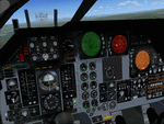
This upgrade to the Alphasim F-111 adds a Weapons System Operator Panel with default and old avionics packages, Working TERRAIN FOLLOWING RADAR scope
shows accurate ground mapping ahead of aircraft in 5, 10 or 15 mile ranges, THREAT WARNING DISPLAY shows airborne AI aircraft in 20 or 40 mile ranges, Ground Attack RADAR displays airports and AI aircraft on default panel and airports as ground targets in ranges of 5,10,30,80 and 200 miles on old avionics panel, Shockwave Lights ready, Updated afterburner effects, INS (old avionics panel) displays working digital readout of latitude, longitude, and altitude, TFR and TWR gauges automatically change brightness between day and night to match lighting conditions.New Autopilot and Lighting control panels. Features custom gauges created by Dietmar Loleit for this project. You must have the Alphasim F-111 aircraft package for this panel
| Filename: | Alphasim_F111_Panel_Package_Version_20.zip |
| License: | Freeware |
| Added: | 7th November 2009, 12:11:41 |
| Downloads: | 917 |
| Author: | Steve Hess |
| Size: | 15.88 MB |
| Category: Flight Simulator 2004 - Flight Plans | |
| OB-18 Junta Colorado |
|
Images related to this file:
File Description:
FS2004 Flight Plan for OB-18 Junta Colorado (New) IFR high speed low altitude military training route. This is the seventh in a series of FS2004 flight plans I have uploaded. This route goes through flat and rolling terrain in New Mexico, Texas, Oklahoma, and Colorado. These are great routes for B-52, F-111, B-1B, B-2 A6, A4, Vulcan and any fighter or bomber enthusiasts. Of course you can fly the route with any aircraft of your choice. Included in this package is a gauge by Karol Chlebowski for TFR flying at very low altitude. This gauge will greatly enhance your ability to fly these challenging routes and is a great companion of the flight plans. Another option to download Version 2.0 of my FS2004 mini panel which has all this functionality and more.
| Filename: | OB18_Junta_Colorado.zip |
| License: | Freeware |
| Added: | 27th July 2011, 23:04:32 |
| Downloads: | 72 |
| Author: | Bill McClellan |
| Size: | 323.36 KB |
| Category: Flight Simulator 2004 - Flight Plans | |
| OB-24 Bismarck North Dakota |
|
Images related to this file:
File Description:
FS2004 Flight Plan for OB-24 Bismarck North Dakota IFR high speed low altitude military training route. This is the ninth in a series of FS2004 flight plans I have uploaded. This route goes through mostly flat and rolling terrain through North Dakota. This route has two different sets of targets. These are great routes for B-52, F-111, B-1B, B-2 A6, A4, Vulcan and any fighter or bomber enthusiasts. Of course you can fly the route with any aircraft of your choice. Included in this package is a gauge by Karol Chlebowski for TFR flying at very low altitude. This gauge will greatly enhance your ability to fly these challenging routes and is a great companion of the flight plans. Another option to download Version 2.0 of my FS2004 mini panel which has all this functionality and more.
| Filename: | OB24_Bismarck_North_Dakota.zip |
| License: | Freeware |
| Added: | 27th July 2011, 23:06:02 |
| Downloads: | 77 |
| Author: | Bill McClellan |
| Size: | 308.4 KB |
| Category: Flight Simulator 2004 - Flight Plans | |
| OB-51 Wink Texas |
|
Images related to this file:
File Description:
FS2004 Flight Plan for OB-51 Wink Texas IFR high speed low altitude military training route. This is the thirteenth in a series of FS2004 flight plans I have uploaded. This route goes through mostly flat and rolling terrain in Texas and New Mexico. This route has three different sets of targets. These are great routes for B-52, F-111, B-1B, B-2 A6, A4, Vulcan and any fighter or bomber enthusiasts. Of course you can fly the route with any aircraft of your choice. Included in this package is a gauge by Karol Chlebowski for TFR flying at very low altitude. This gauge will greatly enhance your ability to fly these challenging routes and is a great companion of the flight plans. Another option to download Version 2.0 of my FS2004 mini panel which has all this functionality and more.
| Filename: | OB51_Wink_Texas.zip |
| License: | Freeware |
| Added: | 27th July 2011, 23:09:47 |
| Downloads: | 75 |
| Author: | Bill McClellan |
| Size: | 260.05 KB |
| Category: Flight Simulator 2004 - Utilities | |
| TDFCalc2004 |
|
File Description:
This package is for FS2004 and FS2002 terrain designers. TDFCalc2004 is made for use with FSUIPC and FS2004. This is a version that includes true heading readings. It is an FSUIPC registered freeware program that requires version 3.? of FSUIPC.dll installed to the FS2004 Module folder. FSUIPC is a vailable on the internet, and this program requires an application registration entered within FSUIPC. Usage with FS2002 or CFS2 requires no registration with the older versions of FSUIPC. LandCalc and TDFCalc2 are small programs which require the input of Latitude and Longitude, in 'DD:MM.decimal' format. Landcalc returns the names of the "CUSTOM" textures required by photoreal ( CUSTOM ) BGLs, and LandClass BGLs ( using values #253 or #252 ). TDFCalc2 returns valuable information concerning the X, Y coordinates needed for the creation of LWM and VTP polygons/lines. TMFViewerCalc requires input as Decimal Degrees.
| Filename: | TDFCalc2004.zip |
| License: | Freeware |
| Added: | 6th September 2003, 21:12:04 |
| Downloads: | 1,729 |
| Author: | Richard Ludowise |
| Size: | 926.3 KB |
| Category: X-Plane - Original Aircraft | |
| USAF F-15E |
|
File Description:
The F-15E is a two-seat, dual-role, totally integrated fighter for all-weather, air-to-air and deep interdiction missions. The rear cockpit is upgraded to include four multi-purpose CRT displays for aircraft systems and weapons management. The digital, triple-redundant Lear Siegler flight control system permits coupled automatic terrain following, enhanced by a ring-laser gyro inertial navigation system. For low-altitude, high-speed penetration and precision attack on tactical targets at night or in adverse weather, the F-15E carries a high-resolution APG-70 radar and low-altitude navigation and targeting infrared for night pods. This model of the F-15E for X-Plane version 6.30 includes the guided weapons shown above as well as drop tanks and electronics pods. Once downloaded, install the missiles, tanks and pods into your weapons folder.
| Filename: | USAF_F15E.zip |
| License: | Freeware |
| Added: | 6th November 2002, 01:21:00 |
| Downloads: | 592 |
| Author: | Barry Leger |
| Size: | 1.38 MB |


© 2001-2026 AVSIM Online
All Rights Reserved
Privacy Policy |